Thursday, April 11, 2024

Cumberland County Wildflowers Spring 2024


Cumberland County Wildflowers


Sunday April  7 , 2024

Dana Koogler solo 


  Kenny had been working out of town at the nuclear power plant.    I had been missing him terribly, but having to stay at home to do various tasks.   Dental procedures.  Doctor appointments.  Pre-op teaching for joint replacement.     I finally got a break and went to visit him and stay the weekend. I was tickled to get to go.      I didn't do anything on Friday except go down and meet him when he got off work.   

We are staying in the Spring City vicinity so we went to Winstead's American Grill to try that out for date night.  It was quite good!    

     Saturday I went shopping.  I got some new sheet sets for outlet prices.  I love fresh, clean, soft sheets for our bed.    They are actually on my supply list for preop stuff.   They want you changing your sheets like a hospital would!   No kidding.   


          I got me some new PJs to wear as I recuperate.   I got a new blouse for Spring. 

I did some painting as a creative outlet.     I have been trying to rest and not overdo it with my knees.


   Sunday I realized I was not far from a location in Cumberland County where I had seen dwarf trilliums in the past.   I last minute decided to go for it.    It was a pretty drive and not too long.

The Spring City area is lovely.   


   I was pleased to see the redbuds in bloom. I had good views across the Cumberland Plateau.

I got to see yellow trilliums, great white flowered trilliums, phlox, wild geraniums, bloodroot, rue anemone, dwarf larkspur, trout lilies.    

     I traveled some rough roads and was glad I had my four wheel drive jeep.    It is filthy now, but that will wash off.   


     I finally did locate my hoped for dwarf trilliums.  It is the latest in the season I've ever gone to look for them.  First I thought they were all gone.   I spotted one and from there I was able to find lots of them.  I even found a new location for them!


   They are vulnerable so I don't give out the location of these.    They are beautiful and I treasure every single one of them since they are so rare.  


      I ran across some white trilliums that *may* have hybridized with the dwarf trilliums.  They were odd looking foliage and very, very small, but otherwise pretty typical in form.


  I am finding that as my surgical date draws closer I am having some significant anxiety.

I learned of a friend who had knee surgery and then suffered serious complications a few months later.

It was the worst sort of news. Very sobering.   

      I am finding because of all these things I am not terribly concerned about wildflowers or anything else.    I am just trying to hang in there.   I am having to force myself to get out and do things.  


   Working on Tennessee Landforms has been a blessed distraction.  


Below are a few photos of what I saw.   Cumberland Gal isn't very thrilling right now, but I am making an important investment in my health and future.  Hopefully this weekend I will get out to see some waterfalls and wildflowers and beautiful scenery.  I have found some inspiration and motivation that was in reserve!   

Below:  A very white form of Dwarf trillium (Trillium pusillum)

Below: pink form of dwarf trillium. Notice how the edges of them are very ruffley and the bloom is usually straight up toward the sky like a cup. 

Above and below" more dwarf trilliums

Above: beautiful shade of pink trillium with wider petals

Below: A very deep, hot pink dwarf trillium amid a grouping of several
Below: The ones pictured here were from a new location! 

Above: Sarvis berry tree in bloom
Above: wild geraniums were out

Below: Beautiful roadside scene in Cumberland Co with the blue skies and redbuds!

Above:  purple phlox 

below: golden ragwort
Below: typical trillium grandiflorum

Above: Dwarf Larkspur
Above: Not sure what this is? ID?  It is something in the phlox family. 
Above: bloodroot. I saw lots of this
Above: red maples in bud
Above: close up of dwarf trillium pair love these colors!
Above: pale pink rue anemone
Above: pair of trout lilies

Below: a singleton trout lily.  I saw lots of these today. 

Above: another very white dwarf trillium in a new location

Below: pair of yellow trilliums


Tuesday, April 2, 2024

Gunter Fork Falls with Smoke Hiker


Gunter Fork Falls with Smoke Hiker   


Round trip distance 16.4 miles DIFFICULT

8.2 miles one way to the falls


March 14, 2002


   Back in 1998 I decided upon the goal to hike to all the guidebook waterfalls in the Great Smoky Mountains National Park.  I purchased the little Waterfalls Guide to the Smokies.  I got started on the goal the first trip down here.   Grotto Falls was first. Then Rainbow. Abrams.  Laurel Falls. All the well known ones.    I worked on my goal every vacation trip to the mountains.  We decided to move to the area so every job hunting or house hunting trip I worked on completing it.   We moved to the area in December 2001. I completed my goal in 2003.  

  The final hike was Hazel Creek coming in around 15.5 miles.   That was a debacle Kenny went through with me.  I was so green and ignorant about hiking still. I conditioned for a year to make that hike so the physical conditioning I had a handle on.  The preparation for the trail otherwise was a failure.   

  Another extremely long hike that dismayed me was Gunter Fork Falls.  It is long enough to need to be a backpack trip.  I  was no backpacker.   I wasn't a very good day hiker to be honest.   I had a heck of a time getting anyone to agree to go with me. I did not want to make that trek solo.   You are a long way from help if you run into trouble especially alone.  

      There used to be a message board for the GSMNP online. It was in the days when social media was just message boards and forums.  No Facebook or Instagram or any of that.   I put a wanted ad on the site trying to round up some company to go with me.   No takers until finally I got a bite.  A fire fighter from Oak Ridge took pity on me and said he'd go.   He was a 900 Miler and an older, far more experienced hiker and backpacker.   He went by the online handle "Smokehiker" He said he'd bring the gear and we'd just go light and stay one night at Walnut Bottoms and come out the next day.  It sounded ok to me so I planned to meet him in Kodak at the visitor center near the stadium.   My friends worked there and I knew if things went bad Lee and Mike weren't going to let anybody harm me.    

      I met the dude at the agreed upon time and place.   I pride myself on being very together and calm.  I try to be cool and collected. I don't like it when I am not.   He showed up and I got out to meet him and suddenly this was a remarkably BAD idea.   I debated bolting and running into the visitor center and hiding in Lee's office.  I calmed myself down enough to resist doing that, but I still was not nice.

I looked at that man and said with NO filter "Ain't no way in Hell I'm stayin' with you in the woods overnight. I don't know you! You are a stranger. I'm sorry. I don't mean to sound hateful or put ya out none, but I ain't doing this. If you don't like it that is too bad. You can either day hike it with me or I'll go it alone. Either way is alright. You decide."  He played it off very cool and didn't get at all upset. 

He quickly shifted gears and said "No worries. I understand. We will just day hike it.  We can do it."  

It will be alright.  I cannot remember who drove us to the trailhead.  That was 21 years ago.   

      I do remember us arriving at Big Creek and getting parked and hitting the trail.   It was a pretty hike.  I had been as far as Mouse Creek Falls and Midnight Hole so I had done part of it before.  

      We had a lot to talk about and he was an interesting person. He was a Vietnam veteran and a fire fighter.  He told me some great stories about working on his 900 miler map.  The time flew by since I was hearing all new stories and the company was great.      

       I remember parts of it as we got to Walnut Bottoms campsite. I recollect thinking this is a nice spot to camp.  It might have been okay, but not today!    He showed me the brake shoe spring.    

     Gary did not miss a trick.  He knew all kinds of things that helped.  He had me bring super light weight shoes to use to cross the creek. I think we both wore aquasocks or the like.  He cut down the weight by hiding our shoes in the rocks where we could find them on the way back and use them again. A very smart man and I was learning a bunch!     

   I remember the water crossing being deep enough it would have been over your boot tops.  It was a pretty spot also.   We made it over without incident.  I had enough sense by now to use trekkers.  They helped a bunch with stream crossings.    I remember winding our way through the trail ever further into the backcountry.    We never saw another soul today once we got past Walnut Bottoms.  

    I stopped us at Lower Gunter Fork falls.. the cascade.  I wanted to see it.  He said we would, but let's hit that on the return trip. I agreed and on we went.  I knew we were only 0.30 miles further to the falls.  I cannot forget the elation and absolute euphoria as we came within hearing and then seeing distance of the main falls.    Gary stopped and made me go first since it was my goal and my first time being there.

  It was so beautiful!  We had pretty decent flow on the falls today.   It is a 150 foot tall curving cascade with lots of pebbles or inclusions in the stone that makes up the face of the falls.    We were cheering! We did it!   He brought along rope and wanted to know if I was okay with climbing up to the top of the falls?  I was game so he tied a rope off and we climbed up through the woods to the top of the waterfall.  Using the rope and staying either in the edge of the woods or on the dry rock face and holding the rope we were able to find us a spot to sit and enjoy the view.  

   We had lunch here in this spot.  I packed us gourmet sandwiches of croissants with ham and cheese. I remember I had baked cookies and brought fruit and chips.  We had us a picnic sitting there looking down the falls.  It was a memory that I'll treasure forever!   This was one of my all time favorite hikes despite the difficulty.   I remember him laughing at me on the return trip for my creek crossing technique.   He said he wished he had a camera.  I was glad he didn't!    

            It helped a lot to make me learn to like this trail.  A few years earlier when I hiked to Mouse Creek Cascade and Midnight Hole with Kenny it was Hell.   Our marriage was ending.   It was in the toilet.   I have a photo of me taken in front of Mouse Creek Falls where I am not crying, but you can tell I am unhappy.  A second or so after the photo was snapped I burst into tears. Ugly crying. The kind you cannot stop or hide.   I don't know if anyone besides Kenny saw it, but I expect they did.  It is a popular hiking destination and not a real hard hike.     It didn't matter to me right then. I was so despairing nothing mattered.   I had lost so much weight I was about 90 pounds. I had a real distorted self image back then and it wasn't good.     Thank the Lord our marriage was saved by His grace, but the memory of the event waits for me like a ghost every time I go there.  It is a visceral reaction that I have no control over.  Hiking with Gary had me distracted enough that it didn't bother me.   I have said that maybe hiking with different people there and having fun would create new, better memories and change my feelings.   It is a lie.   It never changes.   Part of the trouble now is that I have one of the worst memories of my life there as well as some of the best, most fun ones.  

    Hiking up there later in Winter after we moved to Tennessee with Kenny and going off trail up Betty Branch and going to try to see Upper Mouse Creek Falls.   Him chasing me down like a caveman for romance.   I have said it before and I stand by it.  There are too many ghosts waiting for me on Big Creek Trail.     I avoid the area.   Sad, but true.  I do ok on Baxter Creek and Mt. Sterling, but the main trail really gets me upset.  


Above: Me in front of Mouse Creek Falls about 30 seconds from bursting into tears.. crying ugly.   

Above: Mouse Creek Falls 


Below: Midnight Hole 


Below: Gary Powell the first time we  hiked together on the Gunter Fork trip.  


              We stowed our trash and gear. I took lots of photos of the falls at Gunter Fork. We began our return hike.   We did stop by the lower cascade with the pretty pool of water.    Gary said hiking with me was fun and caused him to slow down to stop and smell the roses.   He had not bothered to ever see the lower cascade before!   It was too pretty to miss.


        He seemed a little down or upset on our return  hike.  I asked him what was wrong and he played it off as nothing.  I knew that wasn't true, but I didn't want to intrude. I figured if he wanted me to know what was up he'd tell me.   We made it back to the vehicle and began our drive to Kodak. 

    Once we got there I thanked him profusely for going.  I had made a new friend who really blessed me.     I got to go volunteer in the backcountry office sometimes with him where I met more friends.

I learned a bunch more.  He later told some of the rangers that though guns were prohibited in the park at the time he brought a pistol along because "Nothing was going to happen to her while she was with me!"  He did not want to have to explain to my family why I got eaten by a bear.   I appreciated the sentiment very much, but old smart mouth here couldn't let that opportunity pass.   I had an audience.

I spoke up and said "Well Gary, I didn't realize you were that scared of me!"  to which the rangers gathered there laughed like mad.    Gary's face turned beet red, but he was a sport about it.  He didn't get upset with me.     


            I learned once we were back at Kodak that he had NO sleep the night before and was very, very tired.  Then I felt like a dog.  I put this man through hell. Now he had to drive back home to Oak Ridge exhausted.  I made him give me his phone number and let me know he made it home okay.  He did, but I felt foolish.   That is a good man right there who did not waiver despite my uncool handling of the situation.    I was grateful for his friendship.       I was glad that was over with and he made it home safely.     

            I met a fellow named Reggie who was also a volunteer with Gary.   I became friends with him and was able to go hiking with him numerous times. Once Gary had to flake on me and instead of getting upset I remembered how good he had been to me and showed grace.   I called Reggie up and we went instead!  We laughed so much.  This man maintained twenty campsites. I went with him a good bit to help.   He was another blessing that came from the friendship begun with Gary.


Above:  Gunter Fork Falls.. the whole thing


Above: Top part of Gunter Fork Falls


Below: our view from the top of the falls.. our lunch spot. 


Above: Lower Gunter Fork Falls


Porters Creek Manway


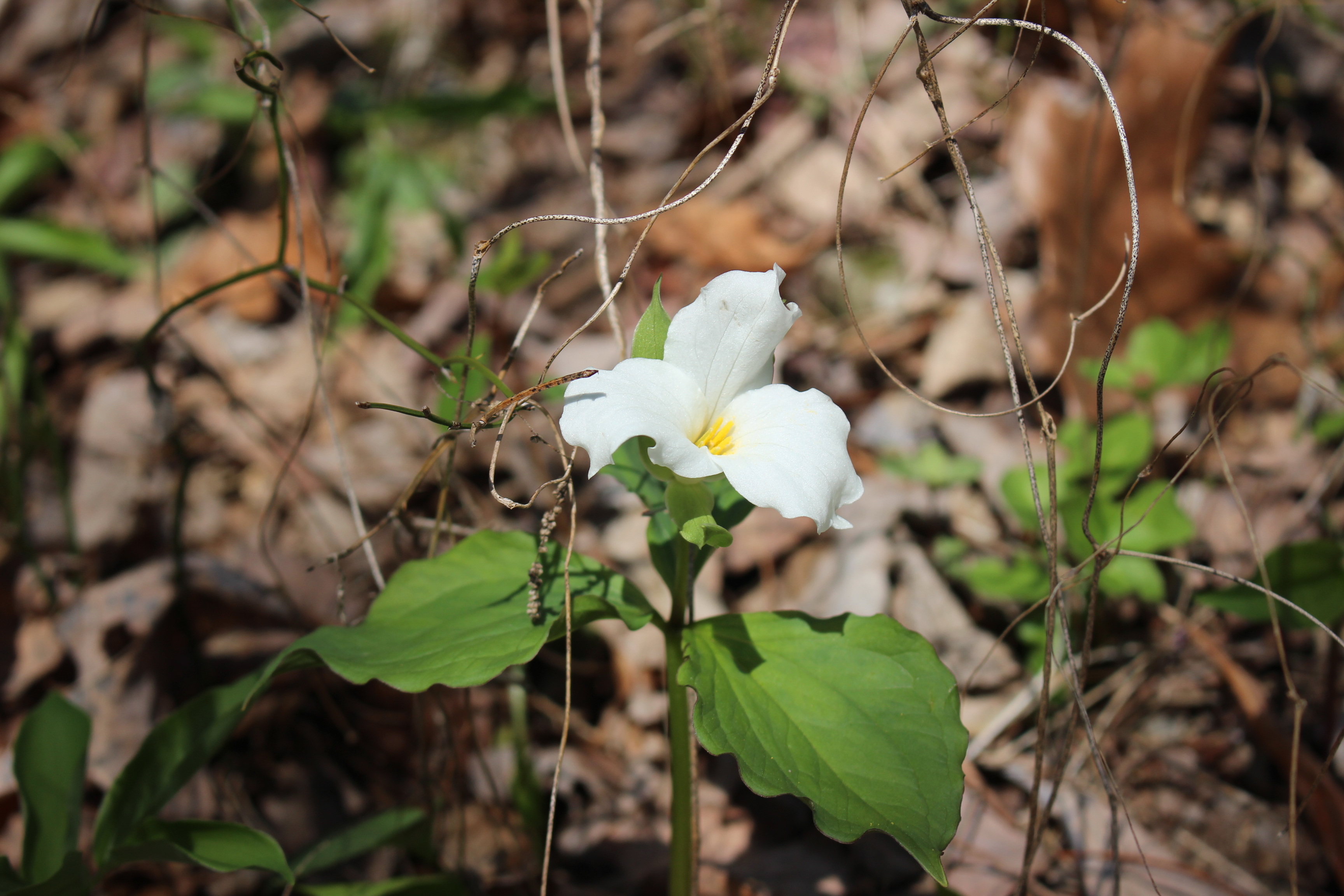
Above: a weird trillium found on Porters Creek trail 


Porters Creek Manway 


Kenny & Dana Koogler 

Oct. 5  2003 

Total hike distance 11 miles
Total elevation gain 
Gradient is 37.8 % on the final mile 
Off Trail Distance 2 miles
On Trail Distance 9 miles 


  I learned of the Porters Creek Manway from the book Trials By Trail authored by Johnny Molloy

He refers to the blue Smokies hiking guide.  I now own a copy of that book, but at the time I did not. 

I attempted this hike with two friends one Saturday.  It did not go well. We ended up atop a fin of rock sitting out there in the Porters Creek watershed.  It was the same spot Morgan Briggs ended up stuck on when attempting this off trail hike many years later.   Thankfully we were able to realize we were on the wrong course and get down again.    The challenge of this hike lies not in the distance, but the physical exertion and navigation off trail.    It is traditionally marked by cairns or little piles of rock that lead you from one spot to the next.   

           It is not the sort of trek that should be attempted solo.  I waited until Kenny could go with me.

We set a shuttle at Newfound Gap and took the other around to the Greenbrier section of the park. Up in the top vehicle we had a cooler with drinks, snacks, and clean clothes tucked away in a bag.    We are a good team. We spent plenty of time researching this and planning for it.   We picked the optimal time of year to make it as simple as possible.  The advantages of making the hike  in early Fall are:

  • Cooler
  • Snakes are in bed
  • Bears are in bed or about to be
  • Stinging nettles and vegetation is not as bad
  • It is our driest time of year so makes the creek levels manageable.
  • Climbing the Wall is a tad easier since it is a little drier and not as slippery.


   The hike begins on the Porters Creek trail and you go out to CS 31.  Once there it is necessary to leave the trail and begin the manway to progress.  You walk down to the stream below CS 31 and start heading up the mountain or upstream.   Watch for piles of stones in the creek. These are the cairns. 

One of your landmarks above you in the distance is Charlie's bunion.   We had studied the map and knew the simplest way to proceed and the correct way is to avoid Lester Prong and go up to the AT beyond the tourist bunion.   I was cautioned back then to avoid trying to come down it, and I never have.  Since that time I've encountered numerous persons who have done it downward from the A.T. or done it as an out and back going both up it and back down it.  It can be done, but it is tricky.  


     The entire hike is 11 miles long with a shuttle vehicle.   The off trail part is 2 miles long with 

9 miles total on a trail.   Four miles out to CS 31 2 miles up to the AT, and 4.9 miles to Newfound Gap parking lot and the shuttle.     The final mile push is where the difficulty really kicks in to high gear.   The grade becomes steeper and steeper until you are literally holding onto grass to stay on the mountainside and you pop out on the A.T. nose first.   The difficulty of it was such that I did not take any photos of this attempt.  I didn't even carry the camera the day we tackled this to lighten my pack as much as possible.  Porters Creek is one of the steepest streams in the park.  I cannot recall sitting here typing this if Porters Creek or Roaring Fork is the absolute steepest, but those are the two worst ones. 


     Once  you have left CS 31 you will be rock hopping upstream. There are anywhere between 10 to 13 crossings.  The route weaves back and forth across Porters Creek.  It is such a flashflood stream that the route does not remain the same from year to year.   It is continually changing.  I spotted the first cairn.  

If you find a cairn that is down please restack it.   Do NOT knock these down as they are traditionally and necessary.    After a lot of rock hopping we took a wrong turn at the confluence of two streams. We ended up going a hundred yards or so up Lester Prong by mistake.  It was very dramatic and rugged scenery.  We saw little water as much of it goes subterranean.     We could see Charlie's Bunion looming over us too large and close for comfort so we knew we'd made a wrong turn.  

   Back down we went and this time bore left to remain with Porters Creek as it climbs into its headwaters.   The confluence of Lester Prong and Porters Creek is a critical point in this trek.  

Stay to the left here heading upstream.   Once we did we began seeing the cairns again.  We finally came to a very large cairn on the left.  It is another critical turning point.  We climbed a waterfall at one spot which was covered in all the logs, trees, and debris washed down from above.  Again by this point the stream is largely subterranean.  That is where the name Dry Sluice comes from.    The stones are very slippery.   Now we began to see Charlie's bunion again to the right, but further away.   The higher we climbed the steeper the grade got.   This is the holding onto grass part.   We were growing tired of climbing on our bellies to hold on.  It is scary, but the focus required is so intense that if you keep your mind on staying on the mountain you don't have time to be scared.   You are just surviving one moment to the next.    I did not look down until I got nearly to the top.  I was weary, but about the time I was most tired my nose popped out at the top of a dirt ditch along the AT .   


               I let out a Rebel Yell that echoed through the mountains.  We had done it!   I was elated. Kenny enjoyed the navigation challenge as well as the physical challenge.   The view from the trail up here is great.     We took a breather and had a drink of water before starting our final part of the hike out to Newfound Gap.    I wouldn't trade that experience for anything.  


   Not to diminish the difficulty of this off trail hike, but since this I have done many other hikes that while shorter have had an even steeper gradient.  One such scared me the first attempt so badly I swore I'd never do it again.  The grade was 65%.   I ate those words a few years later when we took a friend back to see Gold Creek Falls.   The way we went before was THE easy way.   The second time around wasn't as bad since we were aware.  We were able to make the off trail part a bit longer, but not quite as steep by doing lots of back and forth across the slope instead of straight up the gullet!  


      In  typing this up and reviewing the material I learned something I did not know.

There used to be a campsite on the left side of Lester Prong. The blue hiking guide calls it "Obscure". 


Below: a photo of me and Kenny taken together back when I was a  total pussy.  We had hiked to Dark Hollow Falls as a family.  I had not a speck of dirt on me.   I am sure I did not look this way by the time we reached Newfound Gap Road and the jeep.   It just happened to be the first photo I ran upon when digging through the photo albums. It was taken with a film camera and blurry as can be.  

     I recalled a friend wildflower hiking with me in April 2003 after my first attempt on the manway.

He pointed out the water levels.  Would you want to try to cross that stream right now?  To which I responded of course not!   Then it hit me what he was telling me.  I was so new and green to off trail.

I realized the foolishness of attempt #1 and how dangerously high the water levels had been in Spring.

 I buried my face in his chest and burst into tears.   It is a good friend who lets your folly come to you in your own time.     He was a wise man and showed me a lot of grace.   

Below is a photo of Gary Powell who took time to help a green kid understand the hiking world without being mean about it.  


    Johnny Molloy tells of reading the description in the Blue Sierra Club guide to the Smokies.
Page 244 says thus"  The trail consists of two sections very different in character. For 4 miles it is an easy hike in undisturbed forest. After that it turns to an unmaintained manway and becomes very steep, rising nearly 2000 feet in the last mile.   It is for the experienced hiker only and even for him only one way!  Nobody should attempt to descend this trail from the  AT. The latter section is the steepest, most difficult hike in this entire guidebook. DON'T DO IT! 

  To Johnny that was like waving a red flag in front of a bull.   He was hell bent for leather going to do it!  It is the first chapter of his book Trial by Trail.  He titled the chapter appropriately "Don't Do It!" 

His description tells of falling down the manway and landing. He was bunged up, but not seriously hurt.

Just bruises and scrapes.  He tells of arresting his fall and having to gather his composure and crawl back up to where his friend Calvin was.  He tells of laughing and crying intermittently as he made his way back up. That sounds like my style.  Cope by laughing AND crying!   If you've never read his book you should especially if you travel off trail.   It is very honest and relatable.  One thing that I will say about Johnny's book.  I read his account of a canoe trip down Abrams Creek.  I wanted to do it since it was adventurous and sounded beautiful.   Greg Rowe of Little River Trading Company heard me talking about it. He had done it and honestly recounted the event to me and Kenny.   It did not sound fun.    Johnny's trip was shall we say "eventful" in that they lost the keys to the shuttle vehicle in the stream.  They finally located them, but the trip had its difficulties.  I was young and very foolish.  I am now grateful I listened to Greg.   I think he almost certainly spared us a misery trip.  


    Since I have no photos from that trek I will use photos of Porters Creek from another trip. I will also use photos I took  on a hike along the AT through the Sawteeth. I did photograph the spot where you emerge on the trail from the manway. 


Below are two photos of the spot where the manway meets the Appalachian Trail at Porters Gap. 


Above is the bent bridge across Porters Creek.   
Above: A section of  trail before the bridge
Above:  a photo of the bridge from the opposite side

Below: a stretch of trail after the bridge. Porters Creek is a prime Spring wildflower trail.

Above and below: the open areas before Fern Branch Falls

Above: A trout lily in early Spring on Porters Creek Trail

Above: Mossy rocks before Fern Branch Falls
Below: Fern Branch Falls in early Spring

Above: the stone stairs are early on in the hike on the right hand side heading upstream
Above:  a long spurred violet in bloom by the trail
Below:  Porters Creek Trail when some snow still lay on the ground in March
Below: cascades on Porters Creek not far from the parking area. 

Above: a pretty section of the Appalachian Trail near False Gap

Below:  The real bunion viewed from the Sawteeth along the A.T. 

Above: a view from Newfound Gap