

Native azalea blooming in Panthertown
Panthertown Wilderness Backpack Trip
May 31, June 1, 2013
Dana Koogler & Cathy Howell
Pictures are here:
I left home Thursday morning and headed to Asheville for a dual purpose trip.
My son's birthday was Friday May 31st. I wanted to visit with him and do some nice things for him. I got to see his new living arrangements. Nice little house in a pretty, quiet neighborhood in Asheville. Great yard with a creek flowing by and trees! We had lunch.
We went shopping. We sat around and talked and caught up. I helped him with a few chores. He had to leave for work at 3:15 so I kissed him good-bye and we parted ways.
I drove down to my friend Cathy's place in Mills River to wait until she got off work.
We were leaving out in the morning to go on a long planned backpack trip. I was really looking forward to seeing my friend and spending time with her in the woods. Doing what we both love! Hiking and hunting waterfalls and seeing beautiful things is a really good bonding experience. Especially when it involves the task of route finding and bushwhacking on sketchy or non-existent trails.
I unpacked and rested some and fixed dinner for us. We had a nice hot meal of tenderloin, baked potatoes, salad and cantaloupe. I forgot she does not like melon.
Later that evening we had the entire living room piled up with gear from one end to the other. We even put up my tent in the living room. It is a pain in the ass to put up.
I was glad I brought the new tent. We put the Eureka tent away and got out the old stand by.. my new tent. It is brand new, but it is a duplicate of the one I had before the Eureka. I wore the other one slap out! We put that thing up in the dark outside in five minutes!

New tent at our camp site in Panthertown.
We finally got things packed up most of the way and realized how late it had gotten.
We turned in just after 11:00 pm and agreed we'd start when we started the next day. No alarms on days off from work! Very liberating! I don't like pressure and deadlines every single trip. I am the worst about putting pressure on myself.
We arrived at Panthertown and once we put on our packs we headed down Greenland Creek Trail. Neither of us had ever hiked this trail before or seen the waterfalls down there. We have parked in this lot at this entrance and hiked to Schoolhouse Falls and others. Greenland Creek Trail was quite pretty. Lush growth of ferns and a sweet smelling forest were all around. Spring wildflowers are nearly all gone, but now and then we'd see a deep fuschia colored catesby's trillium. They were so pretty! The color looked almost fake it was so unusual for a trillium. We went nearly all down hill on the way in.
We only passed one group of hikers and they were on their way out.
We knew nothing about the area and had set our tent up at the first likely place we came to. It was level and shady. It had access to the creek. We were certainly not going to try to bushwhack to waterfalls with heavy overnight packs on. We were trying to lighten our load for that as soon as possible. A few steps further down the trail and we came to the most marvelous campsite. Twenty feet away was a site carpeted in pine needles under tall pines. It was perfect. We pulled up the tent stakes, lifted the tent carefully and moved it!
Minutes later we had the best campsite ever!
We didn't have to hike far until we arrived at Greenland Creek Falls.
The Panthertown Map shows that the brown dashed trails are the 'official" maintained trails. The real trail ends here at this waterfall. Anything from here on out today was on the red dotted trails which are unofficial trails or manways. They are harder to follow and a bit more extreme. We enjoyed Greenland Creek Falls and ate our lunch here as it was already 3 pm!
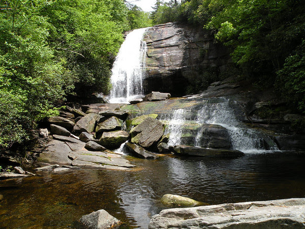
Greenland Creek Falls was really impressive!
Below is a video of Greenland Creek Falls
We did not tarry too long at Greenland Creek Falls once we finished lunch. I did take time to filter some water. We headed on upstream to the rest of the falls we had yet to see. The map listed a "Halfway Falls" and "Carlton's Falls". I knew from descriptions of friends previous trips it was supposed to be a difficult hike to Carlton's Falls. We found out right quick what the trouble was. It is no time after you leave Greenland Creek Falls until you are climbing straight up a steep bank hanging on to trees and roots and rocks.
We made it up there and finally the trail leveled off. We went to the brink of Greenland Creek Falls to check it out from up high. We then re-entered the woods and pressed forward. The trail or manway is not hard to find compared to other trips we've done, but Cathy had her misgivings a couple times and later we did miss one turn.
We arrived at a low sliding falls that was very attractive. We both thought we'd arrived at "Halfway Falls". Turned out it was not right. It was simply an un-named falls that was not even mentioned. Greenland Creek has wide flat spots on it, but it also has quite a few scenic cascades over the course of the trip.

Un-named low, sliding cascade on Greenland Creek.

Greenland Creek flowing off into the distance.

Halfway Falls. We hiked on a bit further and arrived at this beauty! It is not real tall, but very picturesque.
Below is a video of Halfway Falls
The thing that seemed to bother Cathy was when the trail would veer away from the stream and head in the opposite direction while going up the mountain. I could understand why, but I had been paying close attention and there was no place we could have missed the trail or what there was of a trail on the way up. I took a look at the map with her and
showed her where I believed we were. We were in the area on the map where the trail bends out away from the stream then turns back just prior to Carlton's Falls. I just said we'd keep going a little further and if the trail didn't turn back toward the stream we'd head back by 5 pm. Looking around the terrain it was clear we couldn't gain much more elevation and looking a flat creek , growing smaller in the headwaters of a mountain it is easy enough to doubt you'll find a waterfall.
We soon rounded a bend and headed down toward the creek. It was no time until we could hear the loud roar of the falls. Next I could glimpse it through the trees.
Down to the creek bank and out on the rocks and we were there. It did not look like much at first, but as we crossed the creek on the rocks the rest of the falls came into view.
It was actually a big waterfall with multiple levels!

Carlton's Falls from the base

Carlton Falls from the middle.
Below is a video of Carlton's Falls
We climbed all the way to the top of the falls here because the men we associate with
have done so and we weren't to be outdone. I did my usual hooting and hollering celebration. Why not celebrate a successful waterfall finding trip with some chest beating?
We had such perfect weather so far this trip. Blue skies. Sunshine. Light breeze. A few puffy clouds. Temperature right at 80 degrees. All was going well.
We turned and began our hike back at 5:10 pm. We were tired and hot and sweaty.
I was not looking forward to climbing back down that steep slope, but we made it just fine. The only wrong turn we took today was on the return trip we took a side path out through the woods for about 25 yards before we realized we had messed up. We turned
and went back toward the stream and there was the trouble. The path here continued over rocks at the base of the falls for a short distance before resuming the path through the woods. No more missteps after that one. It was not long til we arrived back in camp.
It felt good to take off the backpack and stretch. I got some toiletries and went down to the creek to wash up and I was soon feeling fresher.
We had a hearty supper. I had slivered two New York strip steaks and marinated them then froze them in the marinade. I diced red peppers and sweet onions and froze them in olive oil. I cooked fajita flavored rice and froze that. We sat down in camp and
using two stoves cooked up dinner. Cathy is just learning to use her stove and she picked out a nice one. She used it like she'd been cooking on it for a long time. The food was satisfying and delicious. She washed up dishes while I got the fire started and stoked.
It was a good camp fire. We were both very tired and when dark came we were ready for sleep. The little tent turned out to be just right.

Roaring Fire.
The forecast called for rain on Sunday, but during the middle of the night I woke to rain. I got up and turned on my head lamp and jumped out of the tent to throw a tarp over it as an extra measure of protection. It was just beginning to drizzle. It rained for awhile, but all it did was help put me back to sleep listening to it hit the tarp. I think I slept better after it rained! It was about sixty degrees that night and I was comfortable.
Our tent was on a little bit of a down slope. We had known this but put our heads to the top. It was Hanging Rock State Park all over again. Slide down to the bottom. Scoot back to the top. I remember waking once during the night and feeling boots and things outside the tent wall touching my toes. I knew I'd slid as far as I could go and I just stayed there. I was not going to fight it anymore.
Morning came and the rain had stopped. It appeared the day was going to clear up.
Sure enough the sun came out. It didn't rain hard and the camp was barely damp.
We had some coffee and hot chocolate and cereal bars for breakfast. We packed up and headed out. We had planned to go past two other waterfalls on our return trip.
We disagreed on the route that would take us back past them. I could not get it across
what we needed to do so I chose being happy over being right. I had a heavy pack on and long as we made it back to the car ok I did not care. What I did not want was to wander around aimlessly with that load on my back. Either route back took us to the same parking area. Cathy felt we needed to stay straight on Mac's Gap trail so that is what we did. It was a new trail for us. I was in favor of new scenery.
Mac's Gap Trail turned out to be have several advantages over Greenland Creek Trail.
It was shorter, easier and a far more gentle grade on the way out. Before I realized it we popped out at the parking area about 100 yards down from the vehicle. Cathy was put out a little because we missed the falls. I showed her the map again and explained and this time it sunk in. Mac's Gap trail is the furthest one out to the boundary. It has no water along it except one nasty black pond. Greenland Creek is the stream those two wateralls are on. We had to go back up that trail the way we came in then take a slight detour left and down on a manway to reach those falls. I told her we'd just hit those another trip.
I was tickled at an easy walk back to the car with a heavy pack and not at all disappointed.
We discussed what we'd do next. We planned on hiking to a waterfall we had not been to before. Hidden Falls was shown on the map in the vicinity of Flat Creek Falls. On the way out we stopped and hiked to Raven Rock Falls. I had been there before, but only once and that was years ago. It was well worth the stop to visit today. It was flowing well
and the green trees really framed it spectacularly. I had visited there in Autumn the first time with a group of hikers. The falls here was far more impressive than the ones we missed at Panthertown on our trip out. Raven Rock Falls is about 50 ft high and
the stone is striped beautifully. We passed two other small flow falls on the way in and
got to cross the Bridge of Death once more.

Rich's "Bridge of Death" where you have a choice as to how you die.
Slip and fall over the edge. Bridge collapse and plunge to your death.
Bash head on low hanging rocks at end of bridge and die of head trauma.
But we cheated death once more today!
We arrived at Raven Rock Falls and could hear it long before we got to it.
It was really something to see today. All that silky flowing water coming down over the cliff face with blue skies and green trees.

Raven Rock Falls
The hike back was easy. We saw some flame azalea in the forest. The only flowers blooming were some Solomon's plume and Clinton's lillies. We saw remnants of a trail including markers for it. I later read on www.ncwaterfalls.com that this is the old Toxaway Trail. I want to come back and explore downstream to Fisher Falls sometime.
Kenny has not seen any of this or at least he says he has not.
Below is a video of Raven Rock Falls
We motored on toward Rock Bridge Road to find Hidden Falls. I remarked to Cathy
that "Watch. Once we get there you'll remember you've already seen this falls!" She doubted that. We enjoyed the pretty drive on Hwy 281 and Rock Bridge Road.
We have both hiked to Flat Creek Falls in the past and that access is back at the same trailhead as this Hidden Falls. Once we parked we got out and fixed a hot lunch by the creek. We had chicken breast and fire roasted tomato sauce over noodles. It was even better than the pepper steak! We lightened up the packs for use today and set out.
We crossed the logs over the stream and then came a partial epiphany. Cathy's memory began to clear and she remembered she HAD been to this falls before with Mr. Bernie.
She knew generally how to get there, but that was it. The area was a maze of trails and old logging roads going every which way. The map indicated we needed to pick up a path going opposite of Flat Creek Falls and beyond that it was hard to say.
First we tried going out the trail as if we were going to begin the hike to Flat Creek Falls. She then said no, that was not right we needed to go back and pick up a left turn much earlier. We saw a nice black snake on the way. She was not a fan of the snake or
my wanting to take pictures of him.

Black Snake. Once I put the camera away he did some tricks! He climbed up a log.
We went back past a campsite and took a left turn on another trail closer to the stream.
According to the map if this was the correct trail we should have one more left turn off this trail and that would put us at the falls. I estimated the distance to be about 3/4 mile one way. We had one more snafu on the trail as to where we were on the trail. I think
I figured out the root cause of the difficulties we'd experienced with route finding and Cathy's new found inability to cipher where we were according to a topo map. At some point along this leg of the journey she tried to show me .. prove to me that we needed to be near the creek. I did not dispute that. But what she showed me as a stream on the map was not a stream. It was just a contour line. Someone has arrived at that point of needing reading glasses like the rest of us middle aged folks! It was an Ah Ha! moment and explained a lot.
We hiked along through a rhododendron tunnel deep and dark. It was nice and shady today. We saw either the same black snake or one just like him. Later I picked up a tiny garter snake from trail and held him up to show Cathy what she'd stepped over. She never did warm up to the idea of No Feet. They're all bad! Along our journey I spied the only thing that looked like a spot to make a left turn and we dropped down toward the direction of the stream. We began to see water and the flow grew more and more as we went on.
One more spot where the trail bent down to the left and toward the creek and we began to hear a rumble of falling water.
We finally arrived at a dead end and there was a gleaming pool of water at an opening in the rhodo. The rhododendron encroached and the only way to see the falls was to wade out into the creek. Here is what the first glimpse of Hidden Falls was like.

Lowest level of Hidden Falls.
It is quite pretty, but after that effort to hunt it up some would find just that disappointing. The stream was beautiful and like many creeks in the mountains of Western North Carolina contained flecks of mica.. a glittering gold mineral. It makes a
wade in the creek or a swim like bathing in fairy glamor.

Glittery gold stream.
I waded out into the creek and finally could see a glimpse that there was more
to see upstream! I waded over to rocks and waited on Cathy. We worked our way around a massive boulder with a tree growing atop it. Beyond that lay a birch tree growing on stilts. We were able to see the full beauty of Hidden Falls. It was about sixty feet high and had such a pretty shape. My photo does not show the rim stone at the top.
Formed from erosion and mineral deposition both. It was very impressive and well worth all the effort to hunt. We enjoyed wading the creek up and down. We spent some time soaking up the view here before we headed back.


Cathy bushwhacking back toward the trail
We wrapped up our days hike by timing our progress back to the trail head.
The hike is about 1.5 miles round trip and once you know the proper turns was not that bad. Navigating here to get started was the hardest part. We're a good team.
Back home we went for showers and unpacking. We got clean and rested. We had stopped by the book store for an updated Panthertown map for me. We went out for dinner at Hawg Wild BBQ and icecream for dessert. We spent time reminiscing over old photos and checking out routes for Flat Creek and discussing future plans.
We have really done a LOT of hiking and seen lots of waterfalls over the years.
We slept well and woke the next day to pouring rain. Glad we came on in or we'd have been packing up in a heavy thunderstorm.
We said our goodbyes on Sunday morning and I headed home in the rain.
What a great trip and I so look forward to next time! I need to do more of this with my long time friend.
Below is a video of Hidden Falls aka Nellie's Falls.
*edited to add: Bernie Boyer found "Hidden Falls" and opened the trail to it. He named it "Nellie's Falls" and that is what it is known as on ncwaterfalls.com. That would have been what he introduced Cathy to it as. That was part of the confusion as to whether she had been there before. It was called by a different name.
Ya'll had a great time and enjoyed some wonderful scenery. Good memories hiking in scenic NC.
ReplyDeleteThanks KT. We missed you. You know how to have a good time. I miss your singing and getting in trouble with me! She still does not believe we hiked the Lee Moore Trail. I finally gave up and told her the truth. We didn't do it. We went up to the trail head and stood around smoking cigarettes. :^/ haha! She said " I KNEW IT!"
DeleteNothing better than a good hike with a good friend! The photos were so pretty!
ReplyDeleteThanks Mamabug. I appreciate you taking time to check out the trip report and comment. Cathy is an awesome friend. Panthertown is a beautiful area for sure.
Delete