

Hiking North Georgia-Day 1
Friday March 20, 2015
Dana Koogler solo
Hike Distance 2.5 miles approx.
Pictures are here: Shirley Miller Wildflower Trail Pix
Hiking in North Georgia--What You Need to Know First
I had wanted to hike the Shirley Miller Wildflower Trail for the past three years.
The past three Spring bloom seasons I would intend to go do that, but something else always
seemed to draw my attention away. Kenny had a month long work engagement in North
Georgia that had us staying in the area. One of the nearby hiking locations was that particular trail. It was 37 miles west of us. I figured I could manage to get over there for the bloom season
seeing as how it was less than an hour away.
The trail is named for Zell Miller's wife Shirley. He was the governor and lieutenant governor of Georgia. He served as U.S. Senator from Georgia for five years. I think I read somewhere that she was a wildflower enthusiast. The trail is on Crockford-Pigeon Mountain west of LaFayette. It is Walker County, Georgia. Before you go see the tips below.
- Georgia sells a Georgia Outdoor Recreation Pass you can buy in person at game check stations, state parks, or online. They have a variety of plans to pick from to suit your budget and your needs. You can get an individual three day pass for $3.50. I purchased an individual year long pass for $20. Alan Cressler informed me to be sure to get this because failure to get one could lead to a fine which would be far more costly. Thanks Alan for that and all your great advice. They cover ALL hiking, and outdoor areas including wildlife
- management areas.
- No map exists for this area except purchasing a Georgia DeLorme Atlas & Gazetteer or a
- Georgia National Geographic Recreation Atlas. You won't find one like you would on Trails Illustrated. You know, the typical folded trail map.
Before you buy these gazetteers.... I have used both and have both.
You don't need BOTH. They are about even far as use.
The DeLorme Gazetteer is easier to use for me because I am familiar
with them.
The recreation guide has a little more detail and the boundaries of various
WMAs and natural areas are more defined.
- A couple good hiking guides exist for the area including these

Bridge at the start of the Shirley Miller Wildflower Trail.
Georgia and Tennessee have a boatload of areas they like to call "The Pocket".
Let's address the confusion in North Georgia. The Pocket... a camping area and former CCC camp is down the road near Rome, Georgia. It is NOT the same place. Your Tomtom navigation device or cell phone may not realize what you are trying to do and differentiate so be careful.
The Crockford-Pigeon Mountain WMA is large and has many entrances. You want the one at the end of Pocket Road outside Lafayette, Georgia. It is the furthest one to the west. At the end of Pocket Road it dead ends in a parking area. The bridged trail at the start is the correct one for the Shirley Miller Wildflower Trail.. an 800 foot long boardwalk. At the end of that boardwalk is the 0.1 mile long foot trail to Pocket Falls. The signs say to stay on the board walk. I did not
care for that aspect of it, but I understand it was done to prevent the wildflowers and plants from being trampled.
Also at this parking area to the far left... trail head to Estelle Mine Trail.
In the middle .. near the Shirley Miller Wildflower trailhead is a kiosk and beyond that
is the South Pocket Trail which leads to High Point and goes ABOVE the Pocket Falls.
Some of the wildflowers that are prevalent at this trail that are considered rare in Georgia
along with the trees and plants are not necessarily rare in Tennessee. Wood poppy, bluebells,
buckeye, for example are common elsewhere. Blue ash, bent trillium and trailing trillium are rare
and are found there. Things were just starting to bloom.
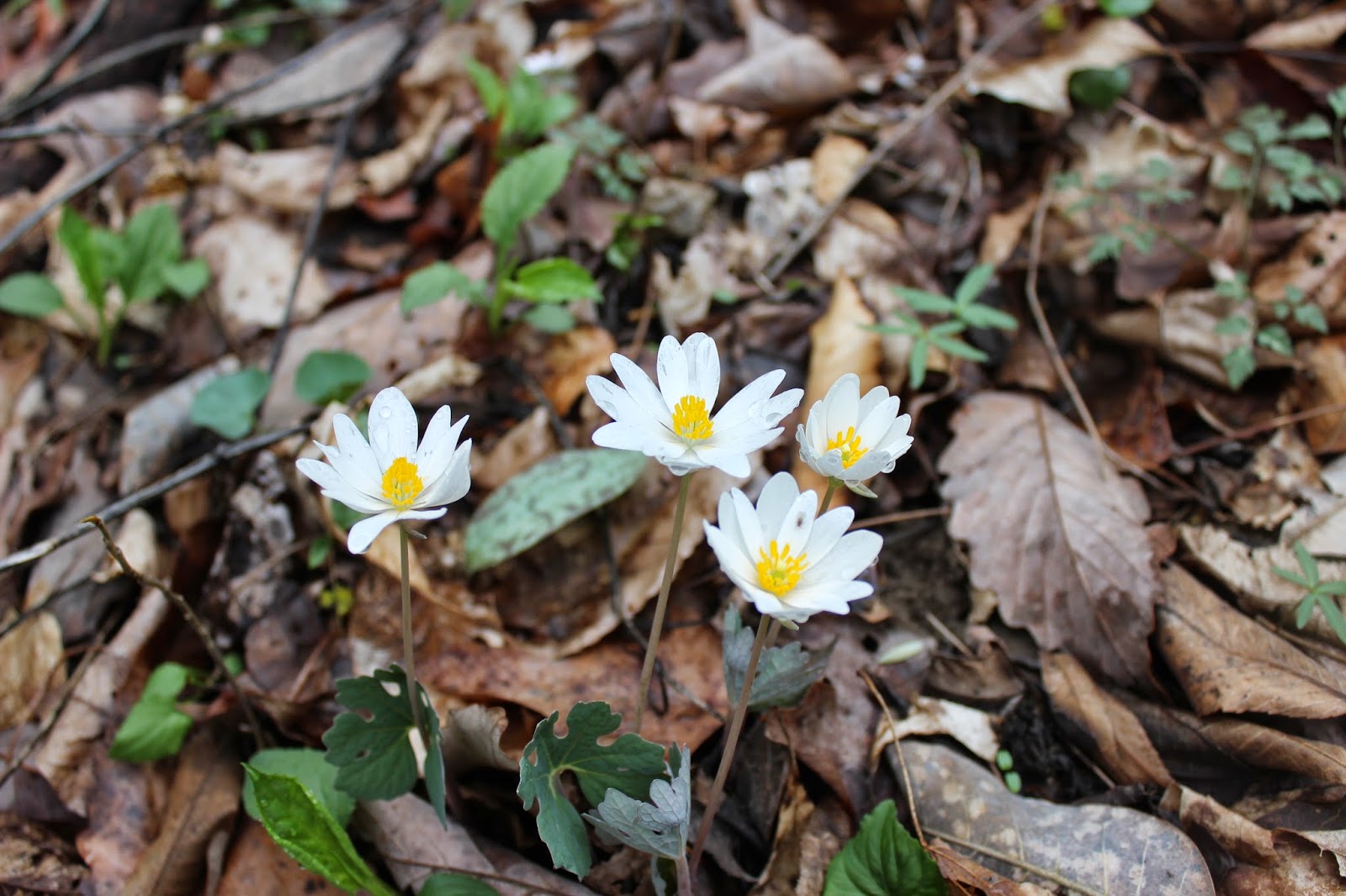

Top -Cluster of bloodroot.
Bottom: beautiful blue Hepatica .. I checked out the leaves and found it to be Hepatica acutiloba
I hiked the boardwalk. I met only five other people today on this trail. A family group of four.
Another lone female hiker. All very nice people whom I greeted. I gave a short, impromptu wildflower walk
for the family group at their request. I then doubled back and hiked the start of the South Pocket Loop.
I saw more hepatica blooming along the rocky bluffs. I realized my mistake in that I was above the falls. I had mainly wanted to see Pocket Falls. I doubled back and greeted the family group again. I laughed at my
mistake in picking the wrong trail to the falls. I was glad to talk to them because they helped me clear up how to reach the falls, that I could go BEHIND the falls into a little grotto, and they told me how to get to Ellison's Blue Hole. I had been down Blue Hole Rd on the way in a half hearted attempt to find it, but I went the
wrong way and ended up at the dead end gated portion of the road.
I went on up to visit Pocket Falls. It is a foot trail at the end of the boardwalk. It is a very short walk up to the base of the falls. They are quite pretty. I did go behind them into the little cavern. Very cool!
They had plenty of water on them to make them pretty, but the longer into the year generally the less water
coming over them. I could tell right off the stone around the falls was created by minerals leaching out of the water. I did some reading later and I think what I have been calling travertine is actually called tufa.
It is softer and more porous than travertine. It has a very distinctive look that to me is easy to recognize
compared to the stone around regular waterfalls. It was an easy hike. I touched upon two other trails. The South Pocket Loop Trail just a tiny bit and a little of the Estelle Mine Trail. I would like to return here again.
 Pocket Falls
Below is a video that shows the falls and the area behind them better.
Another lone female hiker. All very nice people whom I greeted. I gave a short, impromptu wildflower walk
for the family group at their request. I then doubled back and hiked the start of the South Pocket Loop.
I saw more hepatica blooming along the rocky bluffs. I realized my mistake in that I was above the falls. I had mainly wanted to see Pocket Falls. I doubled back and greeted the family group again. I laughed at my
mistake in picking the wrong trail to the falls. I was glad to talk to them because they helped me clear up how to reach the falls, that I could go BEHIND the falls into a little grotto, and they told me how to get to Ellison's Blue Hole. I had been down Blue Hole Rd on the way in a half hearted attempt to find it, but I went the
wrong way and ended up at the dead end gated portion of the road.
I went on up to visit Pocket Falls. It is a foot trail at the end of the boardwalk. It is a very short walk up to the base of the falls. They are quite pretty. I did go behind them into the little cavern. Very cool!
They had plenty of water on them to make them pretty, but the longer into the year generally the less water
coming over them. I could tell right off the stone around the falls was created by minerals leaching out of the water. I did some reading later and I think what I have been calling travertine is actually called tufa.
It is softer and more porous than travertine. It has a very distinctive look that to me is easy to recognize
compared to the stone around regular waterfalls. It was an easy hike. I touched upon two other trails. The South Pocket Loop Trail just a tiny bit and a little of the Estelle Mine Trail. I would like to return here again.

Below is a video that shows the falls and the area behind them better.
The day had been overcast and it began to drizzle rain. I wrapped things up and headed back
toward Lafayette. I wanted to do a little something else to finish out my day.
Ellison's Blue Hole
I visited Ellison's Blue Hole on the way back to town. Blue Hole Road is only a few miles outside the Lafayette city limits. The road you want is not the dead end gated road to the old rock quarry. Follow the road bearing left past an info kiosk. It is a gravel road. It dead ends at The Blue Hole.
Ellison's Blue Hole turned out to be a pretty spot and a good stop. It was worth it, but there is no hike
to it. You just get out of your vehicle and stroll over to it. A pretty stream flowed out of it with a bridge to cross it. A few wildflowers bloomed on the banks. Mainly toothwort and hepatica. I hiked the trail past it
and somewhere back there is supposed to be a place called Cornfield Sink. I did find a depression that may have been it. If that was it... it is not impressive. The trail continues up the mountain and I think that may be part of the trail to the cave, but I am not sure.

Ellison's Blue Hole is a pretty spot. It is the underwater entrance to a cave system.
It was 3:30 pm and I was wrung out. I hadn't hiked much, but I was weary still.
Navigating in a place that was 100% unknown to me had been a strain on my nerves. I was tired. I was lonely. I wanted to go home. I eased back toward the camper. I got cleaned up. I rested. I cooked dinner.
It was good to be here with Kenny and I was glad when he got home from work. Sometimes this solo act
of mine seems to take a lot out of me.
No comments:
Post a Comment
Thanks for reading and commenting. I enjoy hearing from those who read & make use of my blog. I have made some wonderful friendships through emails from readers. I respond to all comments and emails. I appreciate folks reaching out to let me know when my blog entries are not functioning correctly or if the situation somewhere has changed. Many Blessings to you!
Dana 🐝