

Found lots of purple wake robin trilliums at Fires Creek
First Camping Trip of 2016-Murphy, NC
Dana & Kenny Koogler
Friday April 22 thru Sunday April 24, 2016
Pictures are here: Kimsey Highway Pix
Friday April 22 thru Sunday April 24, 2016
Pictures are here: Kimsey Highway Pix
and here: Murphy NC Camping Trip


We decided to take our first camping trip of the year and go some place very different.
We'd long wanted to get more serious about exploring the Murphy, NC area. It is a good central hub to branch out . We stayed at the Peace Valley KOA Kampground., and it was excellent.
It restored our faith in the KOA brand name. I grew up staying at them. Later in life Kenny and I have used them to take our kids camping. We had good experiences.
Back last Spring we stayed at one that was a hair away from losing its franchise. I would highly recommend this place. They also have those little cabins so if we don't want to bring the camper we can book one of those. They let us check in two hours early which was great.
We no more got set up than the rain began to pour down. We ate lunch and took a nap.
Upon getting up the sun was out and the rain had stopped! We grabbed our stuff and headed out.
I had wanted to take Kenny back to see the nearby South Shoal Creek Falls. Me and Mike visited
that in the Autumn. I was interested to know if it was a good Spring wildflower hike?
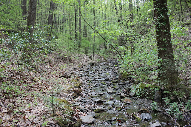
It is a short hike of maybe 3/4 mile round trip. The rain had the creek muddy and raging.
We figured at least the falls would have plenty of water. The trail was a bit muddy in places, but
well graded and we could see someone has been bringing a four wheeler down it. Someone else had a horse on it. The forest was shady with sun filtering in. The stream flowed past muddy and full.
Catesby's trilliums dotted the edges of the woods. Some white and some deep pink or pale pink.
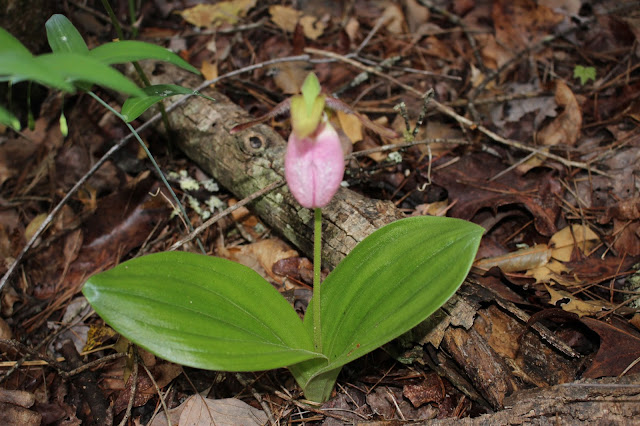
Some had aged to an almost red color. We saw a few pink lady slippers, but only one or two were fully bloomed. Eastern Bluestar, sweet white violet, and fire pinks were a few of the other flowers. Ferns were abundant. Carolina silverbells were dropping their blooms over the path. In short order we arrived at the top of the falls and continued on the trail which curves round to the base of them.
Here is the view of South Shoal Creek Falls we found today. Wow! Lots more water than back in Fall. About four times as much! We crossed the stream by wading back then. I wouldn't dare try it today. The stream flows down below this, rounds a bend like an oxbow and enters Appalachia Lake. No more falls below this, but a few rapids.

Lone pink lady slipper. Perfectly bloomed.
The sunshiney path on the return trip. It was cool, but the sun felt so good.

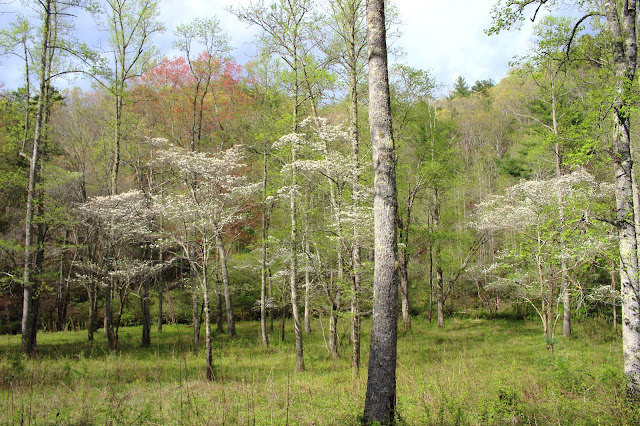
Beautiful meadow of dogwoods on the way to South Shoal Creek Falls. You can see the red maple in there too. Such a nice place!
We strolled around the other parts of the place on some side trails, but didn't really find anything more. It was just interesting and pretty. We decided to head over to Fires Creek next to scout that area and see what we could get into.
We got to Fires Creek Recreation area and continued on FR 340 way on past Leatherwood Falls and the picnic area. We had never been further than that. I had a low opinion of that waterfall and of the rec. area in general. I'd had it in mind from reading North Carolina's Mountain Treasures that I was missing a lot. I determined I would be checking the area out far more closely. I knew there had to be more waterfalls, views, wildflowers and good scenery to be had. It was a bigger area than I realized. I believed then as now that the area is poorly known, and what is known is not well documented at all. I have a comprehensive map of the Nantahala National Forest which includes Fires Creek. I also have the guidebook written about it and the trail system here thanks to Emily Felty. Today was about scouting and figuring out the road system. Roads are often shown gated, but today we found them mostly open to travel! I was looking at an off trail adventure in the area
that I wanted to do. We had to do a reality check to decide which way was going to be best to approach it. We found two additional waterfalls today that were undocumented. Fires Creek is full of scenic cascades all along it. We saw a few wildflowers, but not a lot.
 Profile view of a good sized waterfall far back in the Fires Creek area.
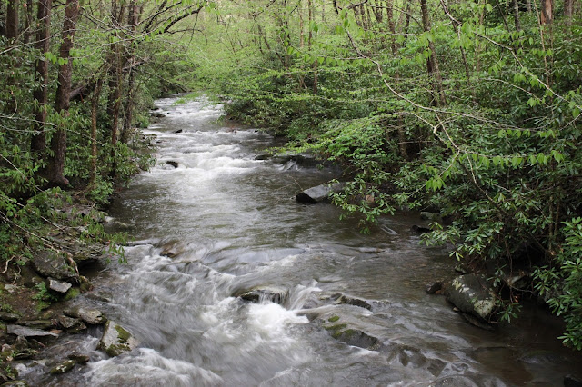 Fires Creek running great today.
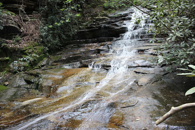
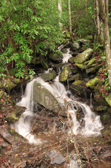 Un-named waterfall we found. It has quite a bit more up from this.

Found the forest around the un-named falls filled with these purple wake robin trilliums, ferns and appalachian bugbane.
The sky turned dark on us while we were way up in the mountain on a back road.
The rain began to pour down in buckets. We finally found a place to get turned around and start back down the mountain. We were pleased that down near the start of the rec. area the rain quit.
It was getting dark and we realized it was very late. The sky at twilight was a soft pale cotton candy pink over the Valley River Mountains on the drive home. We had found what we were searching for. We would try to come back Sunday morning and do our off trail hike.
It was so late on the drive home that Kenny wisely suggested we stop and eat somewhere rather than try to go back to the camper and cook. We'd been planning to have hamburgers and hashbrowns. It was 9;30 p.m. Oh how time flies when you're having fun! We stopped at Arby's and had fast food for supper. Went on home and cleaned up and got ready for bed. We had a full day planned for Saturday. We figured we'd best rest up. Kenny stopped and got a movie at Ingles, but ended up falling asleep instead of watching it.
Saturday morning I fixed breakfast of biscuits and gravy. We had some hot coffee and started laying out our gear to go hiking. The phone rang and it was one of those heart up in your throat ... this is going to hurt like Hell moments. We were sitting here in Cherokee County, North Carolina and getting some very upsetting news from family back home. All at once nothing else mattered. None of our plans made any sense. We didn't want do what we had planned. We just sat down on the couch and cried. Once we regained some composure we held hands and prayed for the Lord's peace and healing and wisdom in the situation and in the coming days.
Kenny said we should try to get out and at least do something. Sitting around crying wasn't going to fix it. I knew he was right, but we both felt ill. Neither caring at all for the original plan of going to Rock Creek and climbing around in the gorge looking for waterfalls. We both felt we needed something milder since we were not focused. Something we could bail out of easily if we became distraught again during the day. I suggested we go ride the length of the Kimsey Highway for a start.
Kenny agreed so we took a few things and set off to try to salvage the day.
I love how these old dirt roads are named "highways". The first one I experienced was the Joe Brown Highway. I had long heard of the Kimsey Highway, but never tried it out. I had loved the first one, so I figured I'd best check out the second one. I did some reading about the history of the place before going. The dirt track started out as a path the Cherokees used to get from point A to point B. Later settlers used it too. Once the Copper Road was built the old trace fell into disuse.
I don't have a real clear understanding of the circumstances, but because of the lack of a good road
a postal worker froze to death and a little girl died in a house fire. Dr. Lucius E. Kimsey, an area physician, paid for the renovation of the road himself , and so it was named for him. He was a civic leader and a compassionate man. He had a brother who was also a doctor. He built an area junior college which was never used in that capacity, but was used as a high school.
Kimsey Highway runs from SR 68 in the east at Harbuck across Little Frog Mountain
in a winding path all the way to SR 30 at Greasy Creek. We wanted to see some things at Reliance
which is up from Greasy Creek. The road begins just behind a store and eatery in Harbuck.
It has a few homes along the very beginning. It climbs upward to the Cherokee WMA. Side roads intersect it at intervals. Trails begin and end along it. It is narrow, but is actually two way traffic with pull outs. We met a mere three or four vehicles the entire trip across it. It is popular with hikers, hunters, and nature lovers. The scenery once you get on up toward the top is much prettier.
Directions to Reach This Scenic Road can be found here or on the What's on the Cover page for now.
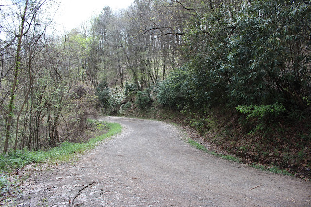 Winding dirt road through the mountain
 Slopes loaded down with wildflowers and plants. This is false hellebore, rue anemone, and yellow trilliums.


We got to Fires Creek Recreation area and continued on FR 340 way on past Leatherwood Falls and the picnic area. We had never been further than that. I had a low opinion of that waterfall and of the rec. area in general. I'd had it in mind from reading North Carolina's Mountain Treasures that I was missing a lot. I determined I would be checking the area out far more closely. I knew there had to be more waterfalls, views, wildflowers and good scenery to be had. It was a bigger area than I realized. I believed then as now that the area is poorly known, and what is known is not well documented at all. I have a comprehensive map of the Nantahala National Forest which includes Fires Creek. I also have the guidebook written about it and the trail system here thanks to Emily Felty. Today was about scouting and figuring out the road system. Roads are often shown gated, but today we found them mostly open to travel! I was looking at an off trail adventure in the area
that I wanted to do. We had to do a reality check to decide which way was going to be best to approach it. We found two additional waterfalls today that were undocumented. Fires Creek is full of scenic cascades all along it. We saw a few wildflowers, but not a lot.


Found the forest around the un-named falls filled with these purple wake robin trilliums, ferns and appalachian bugbane.
The sky turned dark on us while we were way up in the mountain on a back road.
The rain began to pour down in buckets. We finally found a place to get turned around and start back down the mountain. We were pleased that down near the start of the rec. area the rain quit.
It was getting dark and we realized it was very late. The sky at twilight was a soft pale cotton candy pink over the Valley River Mountains on the drive home. We had found what we were searching for. We would try to come back Sunday morning and do our off trail hike.
It was so late on the drive home that Kenny wisely suggested we stop and eat somewhere rather than try to go back to the camper and cook. We'd been planning to have hamburgers and hashbrowns. It was 9;30 p.m. Oh how time flies when you're having fun! We stopped at Arby's and had fast food for supper. Went on home and cleaned up and got ready for bed. We had a full day planned for Saturday. We figured we'd best rest up. Kenny stopped and got a movie at Ingles, but ended up falling asleep instead of watching it.
Saturday morning I fixed breakfast of biscuits and gravy. We had some hot coffee and started laying out our gear to go hiking. The phone rang and it was one of those heart up in your throat ... this is going to hurt like Hell moments. We were sitting here in Cherokee County, North Carolina and getting some very upsetting news from family back home. All at once nothing else mattered. None of our plans made any sense. We didn't want do what we had planned. We just sat down on the couch and cried. Once we regained some composure we held hands and prayed for the Lord's peace and healing and wisdom in the situation and in the coming days.
Kenny said we should try to get out and at least do something. Sitting around crying wasn't going to fix it. I knew he was right, but we both felt ill. Neither caring at all for the original plan of going to Rock Creek and climbing around in the gorge looking for waterfalls. We both felt we needed something milder since we were not focused. Something we could bail out of easily if we became distraught again during the day. I suggested we go ride the length of the Kimsey Highway for a start.
Kenny agreed so we took a few things and set off to try to salvage the day.
The Kimsey Highway
I love how these old dirt roads are named "highways". The first one I experienced was the Joe Brown Highway. I had long heard of the Kimsey Highway, but never tried it out. I had loved the first one, so I figured I'd best check out the second one. I did some reading about the history of the place before going. The dirt track started out as a path the Cherokees used to get from point A to point B. Later settlers used it too. Once the Copper Road was built the old trace fell into disuse.I don't have a real clear understanding of the circumstances, but because of the lack of a good road
a postal worker froze to death and a little girl died in a house fire. Dr. Lucius E. Kimsey, an area physician, paid for the renovation of the road himself , and so it was named for him. He was a civic leader and a compassionate man. He had a brother who was also a doctor. He built an area junior college which was never used in that capacity, but was used as a high school.
Kimsey Highway runs from SR 68 in the east at Harbuck across Little Frog Mountain
in a winding path all the way to SR 30 at Greasy Creek. We wanted to see some things at Reliance
which is up from Greasy Creek. The road begins just behind a store and eatery in Harbuck.
It has a few homes along the very beginning. It climbs upward to the Cherokee WMA. Side roads intersect it at intervals. Trails begin and end along it. It is narrow, but is actually two way traffic with pull outs. We met a mere three or four vehicles the entire trip across it. It is popular with hikers, hunters, and nature lovers. The scenery once you get on up toward the top is much prettier.
Directions to Reach This Scenic Road can be found here or on the What's on the Cover page for now.
Kimsey Highway Directions:
Heading down SR 68 South from Coker Creek drive 4.60 miles from the junction of 68 with Rt. 123 on the left. Turn right on a road that goes up and behind the 68 Diner. The drive is 15 miles across
to Greasy Creek at SR 30. No gas, bathroom facilities or other amenities are available on the road, but stores are at each end of it.
Heading north on SR 68 from Hwy 64 drive 4 miles and turn left just after the 68 Diner on the road that goes behind it and starts uphill. It is residential to start with,but it is not someone's driveway.
The route goes winding across Little Frog Mountain. You will see various roads joining it, but unless you specifically need to go on one of those stay on the main road.
Once in Greasy Creek a right turn will head you toward Reliance and a left turn will head you back down toward Parksville Lake and Hwy 64.


Brilliant yellow trillium freshly bloomed.

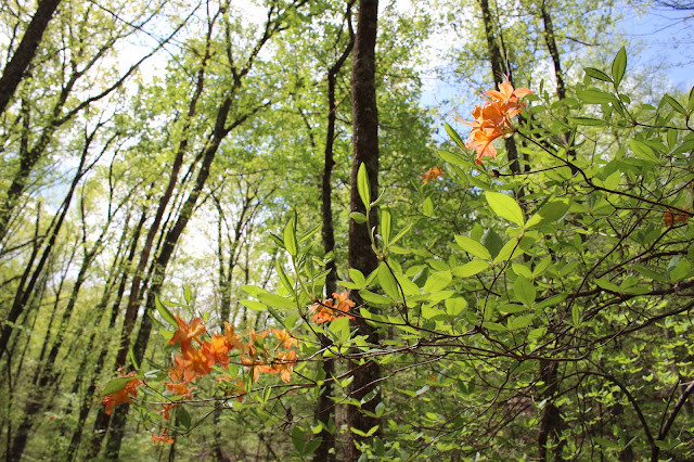
We began seeing flame azalea. My first ones seen this year. Lots of it too!

Cinnamon Ferns in a hanging valley I got out and explored.

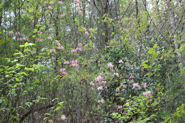
Two shades of pinxter.. deeper pink and palest pink. In the same little hanging valley.

Seepage spring flowing out of a hanging valley. I walked right in the creek, but it was possible to walk beside it in places. Lots of pretty stuff back in there.
Once across the Kimsey Highway to its far end in Greasy Creek we turned right and headed toward Reliance. We hiked up to Lowry Falls and Left Prong Falls. We were surprised how low the water volume was on these falls despite heavy rains! Still pretty. Wildflowers still blooming in the area, but toward the end of their bloom time. Left Prong Falls was choked with debris today.
Lowry Falls is always pretty and an easy hike. The rock here has some interesting bands of color and is very smooth and slick.

One of the tallest drops of the multi level Lowry Falls

Huge patch of Jennison's trillium.

Great big cluster of wild columbine growing on a bluff.

The historic Higdon Hotel. It sits right next to the road. I had never taken time to go see it, but I didn't know it existed until a few months ago.
Short video of Lowry Falls set to Tennessee Rose.. it's beautiful
We checked out the wildflowers and waterfalls. We drove down the road and I looked for pawpaw blooms, but found none. We also stopped by the branch that Spring Creek Falls flows from. It was so little water on it, we did not put the effort into going back there. It is a new falls added to the database by Brian Solomon. We will visit it, but when it is worth the energy. We stopped at Webb's Store and had a popsicle. I spent a fair amount of time at my Poppy's store eating popsicles and walking the grease rack outside. I also would go down to Cash's store on foot or on the bike and sit on the cooling board outside and eat a popsicle with my buddies. Life's simple pleasures!
We made a quick stop across the river to check out the old Higdon Hotel. Once we had done that we headed back round to Farner to visit Turtletown Falls.
Turtletown Falls
The very first time I went hunting for Turtletown Falls I was with friends. We finally found it, but struggled with the directions in Greg Plumb's book Waterfalls of Tennessee . I had been back several times since. The most recent time was seven or eight years earlier. You would think between the two of us we'd have sense enough to find it with ease. We struggled today with the directions as if it were the first time we'd ever been. Local yokels take down signs and vandalise things for one. The directions are as convoluted as the system of roads through the little village of Farner. Farner's U.S. Post Office is in a trailer. I am serious. I entered the GPS coordinates for Lower Turtletown Falls thinking that would help. It didn't. It just caused the Tomtom to try to take us in on the nearest road access possible. What we didn't know until later was that there IS a road that comes in much closer to Lower Turtletown Falls on the opposite side of the river. We pulled over as soon as we saw a lady out on her porch. We knew we were close, but still not having much luck. The lady was kind enough to help us. Sure enough the vandals had ripped down the sign for the Scenic Area.
Someone has put up a very small handmade sign and the road number sign is way back the road out of view. We finally got there and began our hike.
Turtletown is a popular hike. We made the fourth vehicle in the parking area.
The hike is only 3.8 miles round trip if you do it in and back out. The trail is lovely and travels through a pine woods. The stream is seldom far from view. We got to see lots of pink catesby's trilliums, pink lady slippers, vaseys trilliums, and other pretty wildflowers. We saw two other groups of hikers. One man and woman and their blue heeler were fishing. A dad and his three boys were vandalising the trees by carving them. Oy! We passed a point where the wide four wheel drive type road split off in a V. We dropped down to the path on the left where it followed the creek. The other trail continued up the hill and was blazed.
We soon went down the three or four sets of switchbacks and steps to get to the bottom of the trail and the first falls. Turtletown Creek was raging today and this was the most water we had ever seen coming over it even counting Winter trips! It was beautiful, but the spray off the falls made me have to stay back to get decent photos and video.
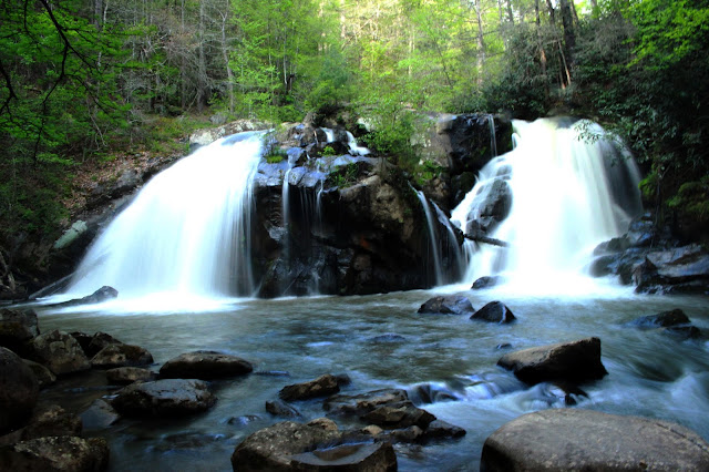 Turtletown Falls
 Pink Lady Slippers were blooming in the woods!
 Turtletown Falls
Below is a video of Turtletown and Lower Turtletown Falls set to Bruce Cockburn's
End of All Rivers.
End of All Rivers.
Once we finished checking out the first falls we turned and continued down the trail along the stream toward Lower Turtletown Falls. I knew we'd have to climb back up some and then come back down to the next falls. The trail was mild and pretty. The forest was fragrant of pine and green. growing things and the scent of the mist coming off the stream. The evening was settling to a soft golden light over the pines. We passed a section of good wildflowers in the forest just before the Lower Falls came into view. I saw some freshly bloomed, beautiful Vasey's trilliums. So deep red they were almost black. Also in the area were more lady slippers, foam flower, and dwarf crested iris.

Top: Vaseys trillium
Bottom:Dwarf Crested iris


We arrived at Lower Turtletown Falls. It looked awesome. The dying light of the day was beautiful by itself. The light here in these forests of the Southern Unaka mountains is different than anywhere I have ever seen. It is powder soft and so easy on the eyes. Golden evening sun in what was left of a blue sky intermingled with the mist off the stream and the deep green pines. Pure Heaven.


Turtletown Creek flows ever onward below the falls. Another view of the pale, soft light in the woods here.
Kenny was fussing at me that we had to get going and not linger too long. We didn't have a lot of daylight left. He had made up his mind we were not going back the way we came. We would take the wide four wheel drive type path that he was just sure would be a better, easier way out than returning the way we had come. I did not want to fight with him so I just obediently went along behind him.
We hadn't gone far when I spoke up and told him I didn't have a good feeling about the way we were going. "Kenny, I have hiked this before. I feel like I have. It comes out way up at the road and you have to then walk the dirt road back to the parking lot where the truck is. I don't think the trails connect here." He insisted he was right and urged me on. We passed another spot where the terrain was grassy and I knew something was not right. Finally as we crested the ridge top I could see the Hiwassee River to my left. I knew we were heading wrong. I stopped and got the guidebook out and read what Greg Plumb had to say of it. He mentions the hike loop which goes like I said... have to walk the dirt road... or go back the way you just came. I was mad. I hollered for him to come back and when he did I showed him the book and the instructions. I put it in gear and hauled ass.
I was not wanting to fuss with him, but he had bitched and belly ached at me to hurry. Now he was costing us time and energy by hiking a long way in the wrong direction. We came out of the woods just before it got pitch black.
He apologized for the mistake, but insists he is still right. I didn't much care long as we were out of the woods and headed back to town. I was now hangry. We were yet another late night getting back to the camper. I was wrung out. We stopped at Zaxby's and got salads to go. I just knew I'd have a nightmare from eating salad this late. I had to shower before bed, but I was barely able to keep my eyes propped open. We fell into bed around 11 pm. I slept like the dead. I slept in the next day until 9 am. I rarely sleep past 7 am. I felt better the next day.
Kenny made breakfast to smooth things over for the mess up the night before.
We laughed about our forced march. Its part of it. Screw ups and Turtletown seem to go hand in hand. I am posting some improved directions at the bottom of this entry.
We ended up just coming home Sunday morning. We did not have time to do anything before check out which was noon. We got home at a decent time. Both of us still shaken from the sad family news we had gotten. Going to need lots of prayers poured over that situation.
Directions to Turtletown Falls Trailhead:
In Farner along SR 68 turn and pass the front of the Farner Post Office which is located on the right hand side of the road in a white trailer. You will next pass a church beside it. You will continue a short distance and cross the railroad tracks. Turn left at the next two intersections.
Then make the second RIGHT turn. You will pass Newman Road on the right which is a paved road.
The second right.. your turn.... is gravel. It IS signed FR 1166 but it is not signed until you have made the turn onto it and gone a few feet. There is a empty sign frame on the right that used to indicate Turtletown Scenic Area. There is a small wooden sign as you make your turn onto the gravel road that says Turtletown Falls. ~~~>. Drive to the parking lot at the end of this gravel road.
**5/1/2021** Edited to add-- the sign for Turtletown Falls is back up along the road at the time of this update. We finally re-hiked this and proved once and for all that it IS possible to make a shorter loop hike. Once you are at the split just prior to Upper Falls go uphill and right to start the "short" loop. It ends up being 3.8 miles round trip. The uphill loop is not really worth doing in my opinion. The trail is muddy and poorly maintained. It had many downed trees along it. There is also not much to see. The only positives were 1. the limited wildflowers along it were in better condition than on the lower portion. Higher elevation meant they were still cool enough to be in bloom. and 2. it was different.
Also at the time of this update the lower falls at Turtletown has a massive tree down obscuring the view. It is very difficult to get an unobstructed view of the falls to compose a good photo. The tree is going to be there a long time because of the way in which it fell and the location. During a time of lower water it would be possible, but not pleasant to wade out into the mud and muck and tree limbs to get right in the stream and take a view. The falls is very wide and it will still be difficult to get the entire thing in the frame while that close to the falls.
No comments:
Post a Comment
Thanks for reading and commenting. I enjoy hearing from those who read & make use of my blog. I have made some wonderful friendships through emails from readers. I respond to all comments and emails. I appreciate folks reaching out to let me know when my blog entries are not functioning correctly or if the situation somewhere has changed. Many Blessings to you!
Dana 🐝