

Close up of Pink Lady Slipper bloom
Black Mountain Loop Hike--Exploring Cumberland County
Dana Koogler
Friday April 28, 2017
Black Mountain Tennessee Pix
 yellow trillium was common


 A piece of the Cumberland Trail atop Black Mountain.

 Chimney and ruins #2
 Pinkster azalea
 Historic spring house

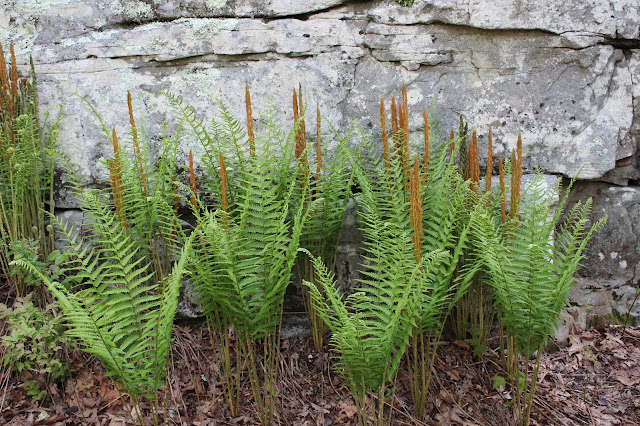 Row of cinnamon ferns at the base of one of the rocks
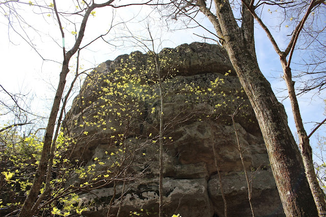 Massive rock in the Spring sunshine. Love those new green leaves. They are dazzling!


 Down the steps between the rocks!

 Yellow birch tree bark and photo below is the leaves.

 Back side of the loop trail on Black Mountain
 carpet of moss on the rocks around the North Overlook


 I first saw Chris Oliver's photos of Umbrella Rock and wanted to visit. I am glad I did, but my pictures are nowhere near as good!
 Umbrella Rock sits right by the road. It is covered in ferns on top!
 Above and below..Fall Branch toward the bridge and upstream toward the cascades. What a lovely spot! Umbrella magnolias hung across the stream and yellow butterflies flitted. The forest here is deep and dark hemlocks.

Black Mountain Tennessee Pix
I had been saying for a long time I wanted to get up to Black Mountain to hike solo.
The reason was that while there one Spring with Kenny I found loads of wildflowers. I wanted to go back by myself so I could spend as much time as I wanted wandering around taking pictures. We did make it back last Spring, but it was with the entire family. It was not the day to go ambling around taking loads of wildflower pictures. We had fun, but had to get the kids back to civilization at a decent time and feed them. I did not see a lot of the previous wildflowers, but since I did not have time to really look I was not surprised. I got up on what was supposed to be a pretty day to carry out my plans. I got an early start so I could have all day to explore.
I got there around 9 a.m. central time. I saw only one other car in the parking lot.
I stopped wherever I pleased on the drive up the mountain to take flower pictures. I started seeing Carolina pinks along the edges of the road. They were eye catching hot pink. I later saw some
deep purple dwarf larkspur. I also saw lots of yellow trillium.


Also saw lots of purple dwarf larkspur

Carolina pinks were plentiful
I studied the banks along the road on the way up the mountain. I drove very slowly. I had found a spot along there in the past where I saw fairy bells, and so many beautiful trilliums. I had planned on parking the jeep at the nearest pull off and wading around the mountainside just taking pictures of flowers. I was disappointed to see that the stuff I found on the previous trip were not there.
It appears that a mowing and weed clearing operation has destroyed those flowers. I have a feeling that unless they quit mowing that area these flowers are finished permanently. It was very disappointing. I understand some brush clearing must be done, but there is no way the small wildflower plants are going to be getting mixed up in the power lines. They need to find some way to leave them alone. I finally got to the parking area and stopped. I gathered my gear leaving my camera out hanging round my neck. I knew I'd need it very soon.


Two pink lady slippers. I saw lots of these today, but they are only getting going!
It was such a sunny, cool day. The sky was blue and the breeze fresh from the rain. It felt good to be outdoors. I decided to leave the main trail and go round to the rocks first. I started seeing other pretty and interesting things. The rocks themselves are fascinating in their size, shape and texture.
Lots of cinnamon ferns sprung up along the trail near the spring house and between the rocks. Cinnamon Ferns are some of my very favorites. Lots of history here atop this mountain. Two home sites exist with their chimneys still standing and parts of the walls. The spring house constructed of rock is a neat addition. I also saw pinkster azalea blooming.


Home site and chimney #1
I wandered around the old home sites first and the rocks. I had some memories come back to me
of things long forgotten. I recalled a guy from the past who used to take his daughters here to this place to learn to climb and rappel. It would make an excellent place for it. I wonder if folks are still doing that here from time to time? We used to be big into the climbing thing, but not for a long time.
I remembered there being cinnamon ferns here, but I didn't know how many! Lots of them. They are beautiful and my favorite fern species. I cannot help thinking about how the landscape might have looked thousands of years ago or even further back. It would have been something to behold the time when the Cumberland Plateau was an island in the midst of a sea.


View out among the boulders.
I reversed course and went to the actual trail and hiked out to the south overlook. I had not encountered a soul up here so far. I wondered where the person was who owned the other car? They had arrived just ahead of me. I saw them pass me as I was pulled off the road taking pictures. I never saw or heard them all day. The view from the overlook was clear and breath taking as usual. It is
a grand stand view out across Grassy Cove. Grassy Cove is one of North America's most notable sinkholes. It comes in at around 5 miles of surface area. All the streams that drain it go subterranean before they leave the cove. The state of Tennessee now owns Devil Step Hollow and cave to the west. It is where the underground water from the streams of Grassy Cove comes back out. They did not even need to do a dye test to figure this out? Why? Long ago the farmers in the area could tell when the folks in Grassy Cove were harvesting corn because the shucks would come floating out of the stream at Devil Step Hollow Cave. It is only open once a month at this time. We were fortunate to catch it open and go on a guided hike in the past. I hope in the future they open it more often.
I'd love to do more exploring there especially for wildflowers. Today sitting here at this overlook
under clear skies with the breeze blowing and listening to the birds sing was a little slice of Heaven.
I watched as the buzzards soared near the overlook. They are scavengers, but in the air they look graceful. The breeze was pretty stiff and I was glad I had on a jacket. I soaked up all I wanted of the beauty and mosied on to see what else I could find.

View from the South Overlook across Grassy Cove and toward Brady mountain.
Click the link to watch the video South Overlook Video
I rejoined the trail and continued the loop hike. I went out to where the Cumberland Trail departs and heads toward Windlass Cave. I hiked down the steps constructed between those massive boulders. They are the size of rooms or houses! It is always impressive to me. They are beautiful in their own right. They are adorned by moss, lichens, ferns and various wildflowers. It was apparent that some of the wildflowers were not yet blooming while others were finished. I was a little disappointed in the amount and type of wildflowers here. The ground among the boulders was filled with mayapples in bloom. They smelled sweet! I took in all the various holes and crevices of the rocks. I turned on my GPS unit and had it tracking me to "Black Mountain Rocks". Before I knew it I was like Brer' Rabbit in de briar patch.. his laffin' place. I was getting clawed up by blackberry briars. I was also not able to see my feet in some spots thanks to the underbrush. The ground was extremely rock with holes and soft spots. The GPS said I had another 527 feet of this. I decided I was not going to risk getting snake bit and I was not willing to get clawed up over it. I'd pick a better time. I need to wait til it is cold and the snakes are asleep and the briars and brush are dead for the season. Work smarter.. not harder. I turned around and went to complete the loop hike.


You walk right under this boulder covered in the prettiest deep green moss and ferns!
I continued the loop hike. It is very flat with hardly any elevation change. I passed the big weather station up top. I had hiked this before, but it was long ago. It really is pretty. Ferns and yellow trilliums grew everywhere. I saw more pink lady slippers. I saw yellow birch in quite a few areas here atop the mountain. Black Mountain is a quirky place. You can find mention of the population of "disjunct northern species " here on this mountain. One of which is yellow birch.
Another that is mentioned is the Showy lady slipper. I have read that back decades ago they existed here, but I have also read more recent publications that state experts feel it may be extirpated at the site. Apparently it has not been found here in a long while. I have read in an individual's blog and
on a campground website the same words about the yellow birch and Showy Lady Slippers.
It reads identically so it seems to me neither of those sources of information is credible. I'd say they are parroting back things they've read elsewhere. I wish they were right for I'd love to find it here.
I have looked several times without any luck. Yellow birch trees grow from Canada all the way down into North Georgia. The further south you go the less of it you see. We have hiked to high elevation streams in the Great Smoky Mountains and seen these trees a plenty. While hiking to Upper Ramsey's cascade we saw loads of them. It was so wet up there the yellow birch trees had water running out the ends of their branches! I've never seen that before nor since.


I remembered there should be an overlook on the back of the loop. It was not long until I came to it. The forest on this side of the mountain is very beautiful. It is deep and green and filled with bird songs. The view is not open here because the trees are still standing and it is only a partial glimpse into the valley below. The up side to that is that the birds sing more sweetly because they are nearer.
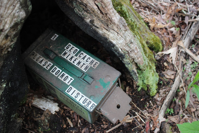
Their homes are all around you. Looking out through the forest at the valley below from this vantage is like looking at an old post card. The soft subtle tones of the earth, sky, vegetation are easy on the eyes. The setting is soothing to the ears and senses in general. I passed great patches of velvet green moss. I passed amazing fins of rock jutting from the mountain side. I also saw a geocache! I entered my name in the log book which has been going continously since 2001. I did not take any objects out, but I did put something in. Fun!


Two fins of rock just down over the mountainside.

Geocache found near the overlook!

View from the North Overlook. Click the link to see the video and hear the bird songs!
I enjoyed the quiet of the overlook and finally pulled myself away to finish my hike. I completed the loop hike and leisurely strolled back to the jeep. I saw a few other wildflowers on the way. A few fire pinks, golden alexanders, and a little bit of blue phlox.

Fire pink
Phlox
Back at the jeep I still saw only the one vehicle aside from mine. I had brought lunch with me, but was too excited to eat right now. Instead I got a sip of something to drink and started driving down the mountain very slowly. I continued to scan the banks as I went in hopes of seeing the fairy bells I'd been treated to years before. I never did find them. Yes, I CAN identify wildflowers going down the road at 35 mph. Shoot, I can ID them going down the interstate at 70 mph depending upon the plant! I did see one cluster of great white trilliums hanging on way up a steep slope. I will give it some thought and decide if I am giving up on this area for good botanically or if I am just taking a hiatus. It frustrates me to try to gauge when stuff blooms here. I come one year and it is too early. I come another year and I'm too late for other things. I believe if I do come back to botanize here I will make it a study area and visit monthly from mid March through September.
Down at the bottom of the mountain I decided I'd get back on I-40 and drive round to Westel Road. I wanted to check on some things there in the area. I was not in the mood to go to Ozone Falls today. I had other stuff I wanted to do. Instead I took a back road and went round to see Umbrella Rock and Fall Branch.

 Umbrella Rock sits right by the road. It is covered in ferns on top!

Below is a video of Fall Branch. The color of the water is that aquamarine that I love!
I did not hang around Fall Branch long. I saw lots of posted signs and began to be uneasy. I was not sure if they pertained to the entire property or if it was just the land on the far side of the stream?
Once I saw them I decided I'd best move on until I knew more about the situation. I did not see anyone out while back in there to stop to ask. It is a residential area and I was uneasy being alone.
I did some more checking once I got home and I will tell you what I found out in another blog entry soon to come.
I wanted to go back round to where we used to ride the four wheeler. I had not been there in three years. I had such fond memories of good times there with Kenny. I believed I could find it and walk back there. I did find it back Dogwood Road, but once again I encountered posted signs.
I did not remember if these had been here before or not? I was committed now and had no choice but to continue to the road's end so I could at least find a spot to turn around. Once at the end of the road I could see tracks and it was apparent someone is going back there in a four wheeler. I decided to chance it and just walk down the dirt track into the woods. I walked down the red dirt road with water trickling everywhere. I hoped I'd see wildflowers. I did see lots of dwarf crested iris, but nothing else. The forest was still pretty. I came to a nice little stream under the deep gloom of hemlocks. It hit me then that my memory of the trail was sketchy at best. I realized it was probably quite a lot further back in the woods to where I'd seen all the good lady slipper orchids in the past.
I turned around and went back. I enjoyed the peace of the forest. I never saw a soul back here today.


Below is a short video of the creek in the woods. It is "quiet" except for the sloshing of my boots as I tromp through the stream at one point.
I hiked back to the jeep and stowed my backpack. I was tired and happy. I had the drive home to face so I decided to get going before getting hung up in rush hour traffic. I'd had a pretty good day and did not want anything to harsh my mellow. I already had plans to return here with Kenny as soon as possible. It did not take anything to convince him we needed to go back. Lots left to explore!
We rode back to the truck and loaded the RZR up again. We drove round to the entrance to the area we ride in off Alloway Road. We unloaded and went off exploring. Several things had piqued
my interest in returning to ride here. I took down waypoints for all of them. I left them all at home except for the one that I truly did not think we'd ever find! It ended up being the only thing we did find on my list! We still had fun. I had seen there was a trail to Black Mountain Rocks. I had seen
that below it should be a cemetery and ruins of possibly a home site. I had also realized we had NOT found The Basin in that holler as we imagined. We found Basin ROCK and falls.. not the Basin itself. I wanted to see it. I figured there must be a good waterfall there.
We did not find it today. We did find the access point of Highway 68. I figured we'd never find it and that it did not exist. It did exist and you can come in from there if you want to. It looks like it is not used very much. The woods were pretty and very swampy and wet! We did find the trail that cuts over to Black Mountain Rocks, but since I was set on finding The Basin we focused on that. It was in the opposite direction. All we managed to find was some pretty scenery and some cut through trails. We talked to some men who we encountered. They were riding too and the only persons we saw all day. They clued us in that The Basin was foot traffic only which I figured. They also said
they had never been up in it and did not know what was there if anything. They informed us that
logging had screwed up a lot of the old access points and trails. We were already aware having dealt
with that very thing just before we ran upon them. They went on to say that Basin Rock and the falls in it are now fenced off. The land owner got tired of folks trashing the area. He put up fence to keep folks out. People were building fires out on the rock which makes it ugly and damages it causes it to fracture. They were littering and just being an all around pain. They said they asked him if he minded them riding in there and he hemmed and hawed. He did not want to tell them no as he could see they were locals and responsible men. He did not want to say yes and then have others assume he meant it was ok for all. It always ends the same. A few assholes ruin things for everyone else.
We were glad that at least we had gotten to see the place before access was cut off.
I still will get to The Basin proper one day. It just was not in the cards today. Did see some nice pink lady slippers and some wet weather waterfalls!


We left having not found all we sought, but had a good day on the trails and in the woods.
It just means we have a reason to return.