We had planned on sticking around closer to home this weekend. Kenny had things
he needed to do. Jared planned on coming up to visit. I hoped we could get out for even a short
family adventure. Turns out we got to go someplace I'd recently noticed. We visited
Buffalo Spring State Game Farm. It is a wildlife management area and fish hatchery. Below the hatchery is a small waterfall and spring pipe. I had not been super impressed with the photo I'd seen of it on Tennessee Landforms. I saw someone else's photo of it and it was way prettier than I'd thought! I was sure it would be a fun place to cool off and have fun on a hot Saturday.
It took us a little over an hour to get there. Gabe napped a little on the way so he was rested.
We had directions from Google Maps that turned out to be jacked up. There was a far simpler
way to get there so the drive home was much easier and shorter by about fifteen minutes. I have included a link at the top from Tennessee Landforms that provides info on how to get there.
It is open to the public.
We pulled down to the parking area right next to the water hole and falls. We saw two other vehicles there with family groups fishing and kids playing in the water. They were fixing to leave as we arrived. We ended up having the place to ourselves the rest of the time. It is permitted to fish as long as you don't fish above the falls. I was wading around in the stream and plunge pool with big trout! One leaped clear up out of the water! It is very clear, cold spring water. It has beautifully colored pebbles in the creek bottom. Gabriel was tickled to see a waterfall. He got in the creek, but
quickly decided it was too cold to suit him. He got in and out, but could not tolerate staying in
the water for long. He played with boats and a water wheel and pitcher while I took photos.Kenny
kept him happy and I got over there and messed with him. I showed him about pouring water
through the wheel rather than putting rocks and sand in it. I gathered up pretty pebbles for him to
throw or collect.
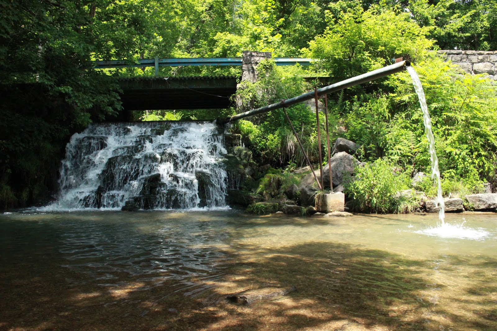
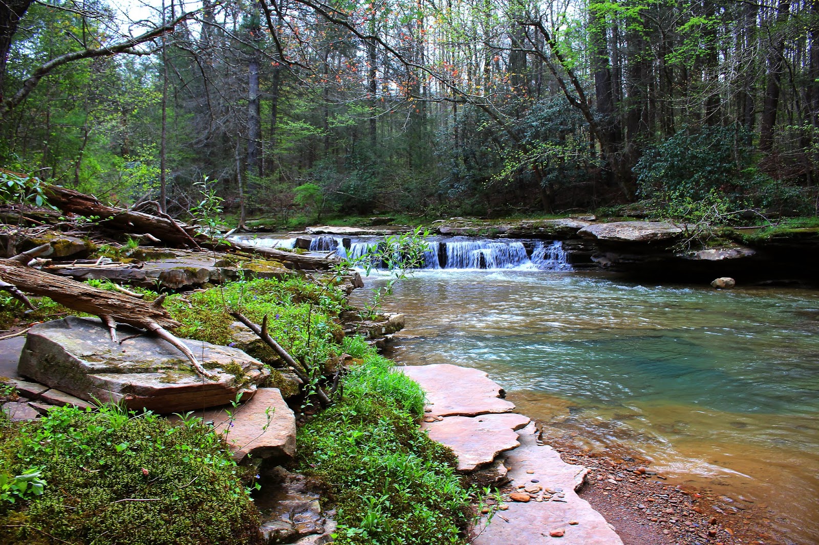
Below: Buffalo Spring Falls has a large pipe sticking out for folks to fill tanks with water.
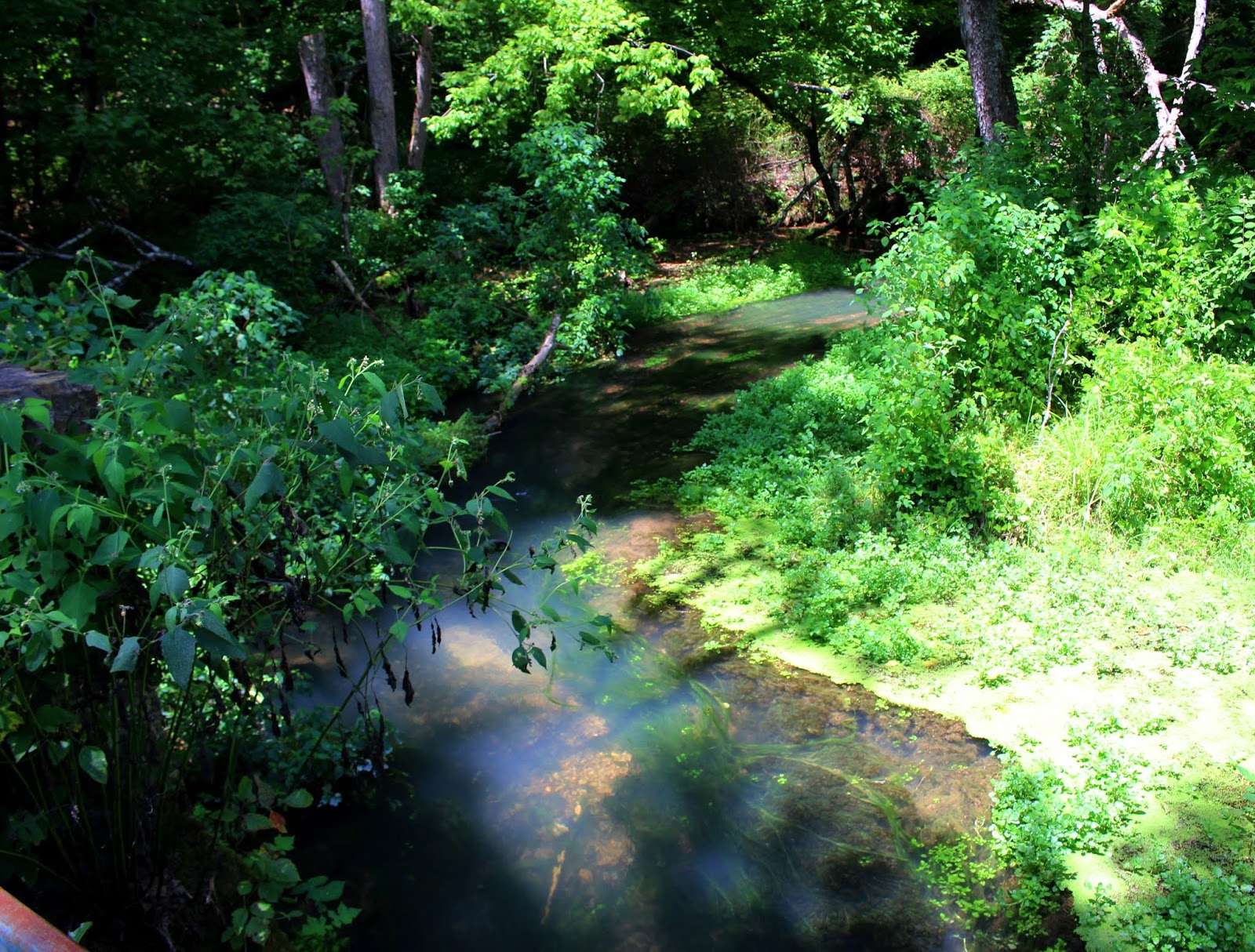
The stream above the falls has a blue cast.
Above: the pebbly bottom of the stream. I always love this look.
Buffalo Spring is covered not with slime or pond scum. It is duckweed. Each plant is teeny tiny.
Above: Gabe plays with the water wheel
Below: Gabe throws rocks
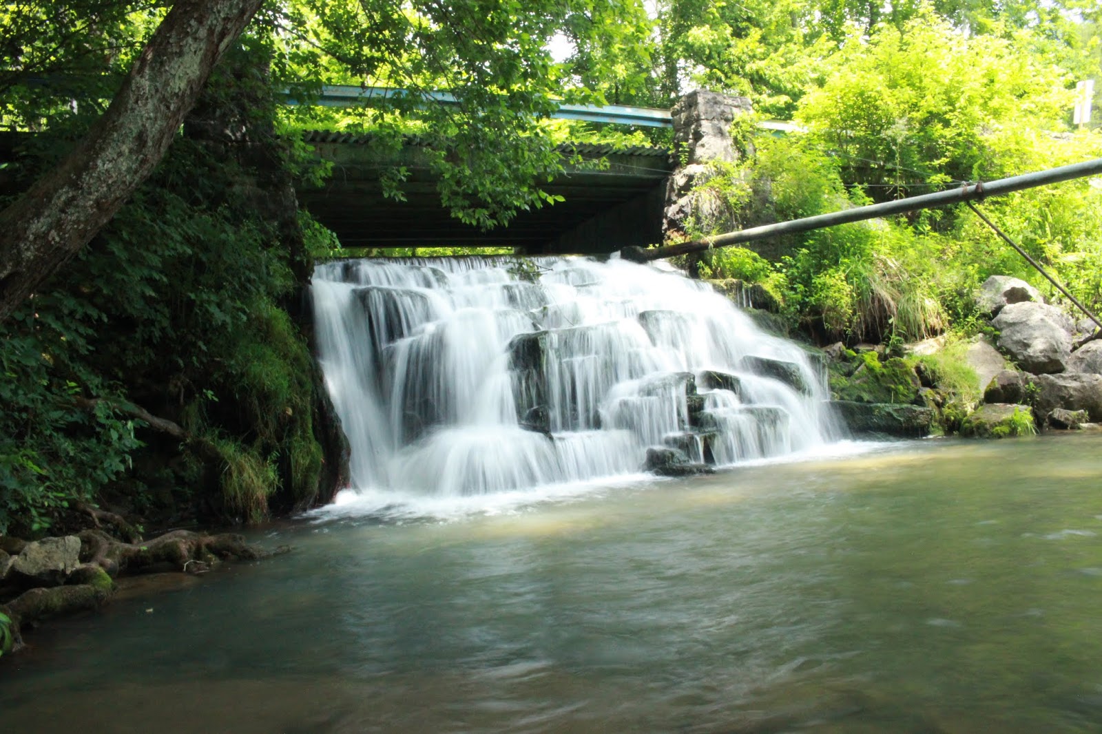
Above: A front and center look at the falls.
Below: a long exposure shot of the falls alone
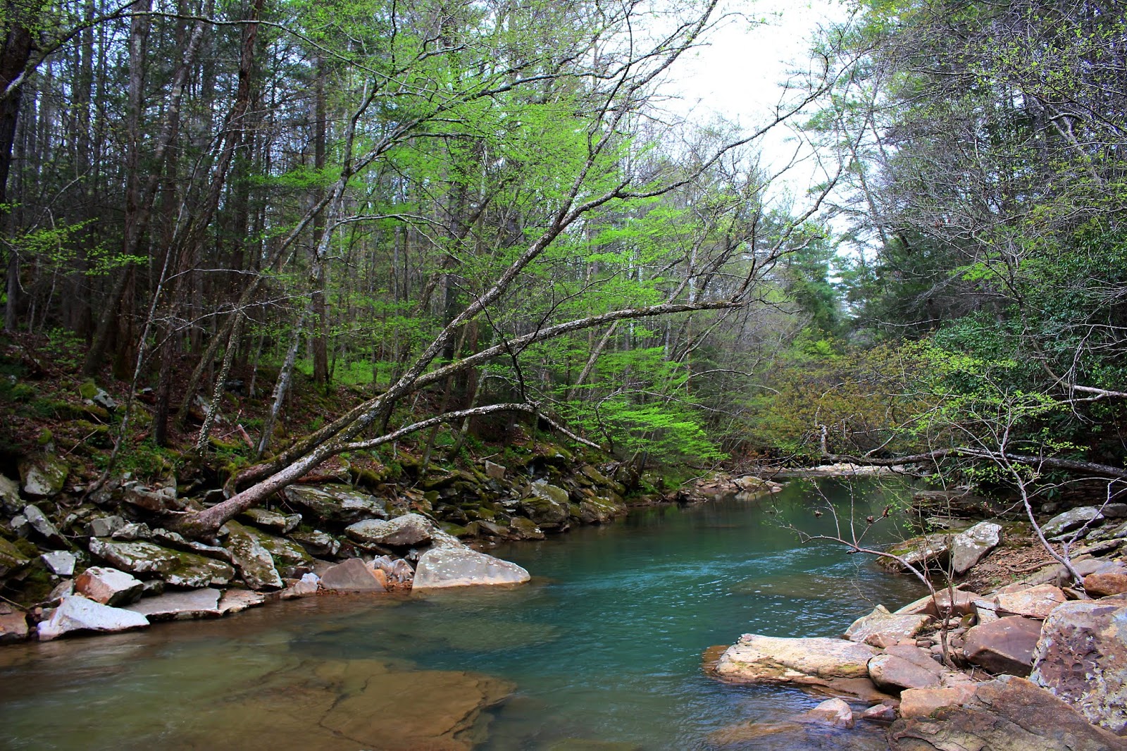
The stream below the pool was shallow and dappled in deepest gloom and brightest sun peeping
through the canopy above. The green trees and quiet waters were a soothing sight. I enjoyed it very much. I waded the stream, but Gabe and Kenny did not care for the "cold" water. The stream bed
while pebbly also had moss that varied from slick and frilly to dark and soft like wet carpet.
Snake doctors shined in the light and flitted from plant to plant. Orange jewelweed was one of the few wildflowers around. It is an all around nice spot.
We got back in the jeep and drove up toward the hatchery. They have it gated off and we couldn't walk along and see the fish. It used to be a private residence. They have turned it into a park.
It has picnic grounds with several tables. It has a basketball court. It has toilets. It has two swings.
The grounds have walking paths and lots of shady spots. The lawn is kept and very pretty.
It would be a good place to bring along a picnic. Chances are you'd have it to yourself.
Below is a short video of the falls. I used the Go Pro for the first time to shoot the video. It is much better than what my camera can do. I plan to use it much more frequently. Its fun. It will make for more interesting blogs and better You Tube channel as well.
Future Trip Ideas for Grainger County & Surrounding Area
Spring is my favorite season. It is the most perfect time of year to me. It is not hot yet.
Most streams are flowing really nice and wildflowers are coming up. The woods look new.
I have always said my favorite color is green. The shade of pale green of new leaf buds in Spring.
Kenny was going through back problems and facing surgery. He was not in any pain, but he was uncomfortable thanks to the numbness in his left foot and leg. He couldn't hike very far.
We've been tied down a lot by raising a child. We've tried to work on our relationship and keep it
tight. Our idea of a "date night" is getting out to the woods together. We'd have to take the
RZR and go on a ride. I was torn between three places. 1. Tackett Creek 2. Royal Blue, and
#3 Gobey. I've written before about my "muse". I guess it is the Holy Spirit leading me.
Whatever it is..... when I listen I can bet on things being really fun adventures. It had been
awhile since I really heard from my muse. I got a strong vibe that Gobey was where we
needed to be. I told Kenny and he was quick to agree. He had been riding there before with
Buck and the fellers. It was quite a long time ago. He was keen to see that area again.
I also found us some additional riding to tack on to what Kenny already knew of.
It is always exciting to go to a new area. The drive out there was a pretty Spring morning.
It was the perfect temperature and the day promised to be pretty. The sky was blue and the breeze soft. I had done a bunch of research to find a safe place to park that would be convenient and acceptable to Kenny security wise. Gobey has a reputation of being one of those places you
don't want to mess around unless you are from there. It is a long ways out there in Morgan County.
I was not sure if the reputation was imaginary or the truth. We turned off Highway 27 just outside
Wartburg. It was no time until I was hollering for Kenny to stop the truck! I was seeing
amazing wildflowers. My day started off perfect. I was seeing the prettiest wildflowers that I had
never seen before. One side of the road was the Emory River. The other side was a slope that went up into the woods. Blue phlox, sweet betsy, southern red trillium bloomed on the bank.
Great quantities of it. Among all that pretty stood some flowers that were different. Trillium sulcatum of cream color and pink! Hybrids between the red and cream. I'd seen red, I'd seen pure white. I'd never seen cream or pink. I saw pink striped ones!
My first glimpse of wildflowers at Gobey. The air here was perfumed so strongly with phlox it was intoxicating. Fresh country air and all the fragrance of those newly bloomed flowers!
Cream Trillium sulcatum
I took a ton of pictures. I walked all around checking out the flowers. Kenny pulled down the road and kept watch for oncoming vehicles. He was really patient with me.
Hybrid trillium in a pale pink shade. It looks like Trillium simile mixed with the red form of T. sulcatum
Finally I had taken enough photos and got back in the truck. We continued on to where we unloaded at a pull off near a bridge. We were well off the road, but close enough to route 27 to
be a little more safe. Isolation provides a chance for a rogue to break into your truck and steal it
and your trailer. We have friends who have experienced all kinds of thefts. We did not want to
join the crowd.
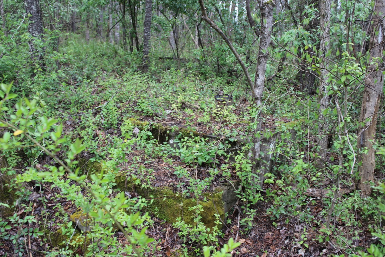
While Kenny unloaded the RZR I got out and walked down the bank into the bottom land near us.
I saw some bridge abutments. They must have been for something to cross the Emory River.
Above: the gorgeousness of the Emory River in Spring.
Above; Bridge abutment or some sort of man made structure.
I had learned prior to this trip that Frozen Head State Natural Area is much larger and has different use guidelines than Frozen Head State Park. The trails on the natural area side are
open part of the year to ATVs, horses, hiking, or mountain bikes. They are closed to ATVs from May 15 to Aug. 1st each year. They all lead across the Emory River from Gobey Road up into
the mountains. They are numbered one through five with the numbers going up the further out you go. We hadn't gone too far until I started seeing abandoned houses. Gobey is a former mining community. When the coal mines diminished so did the little town that had grown up around the industry. It is still a place with a ton of natural resources. The roads on both sides of the river
often lead to gas wells. It is permissible to ride on those too as long as you don't meddle with the gas wells.
Trail use sign on the gate at Sang Branch.
We soon came to the first gate. Sang Branch is gate number one. We'd ride up that and see what pretty things lay in store for us.
Below is a view upstream on the Emory River.
It is pretty here and in Spring there is plenty of water.
The further up the road you go.. the higher into the headwaters you are. The stream size diminishes a great deal. We later learned that in Summer it dries up to holes of water.
Below: Looking downstream on the Emory River at the same spot. We're sitting in the stream.
Below: The remains of an old stone wall beside the Sang Branch gate. Evidence of past human dwellings.
The Sang Branch trail runs from the Gobey Road all the way up to Ross Gap. Another trail continues down off the mountain from Ross Gap toward Flatfork Road. I think that comes out on private property. We have since hunted for the access along that road and there is only one place it could be. Maybe one day we'll finish figuring it out. Sang Branch trail changes its character
from the bottom to the top. It is a winding, rutted dirt track with mud holes. It passes through a
dark, close sided hemlock gorge at the bottom with the creek cascading down through the bottom
of the gorge. We saw a few other rock structures from old home sites along it. The trail then starts
through a forest with a more open canopy. Dogwood trees bloomed and the trees had tiny green buds. We also saw red maple leaves. I saw a big tooth aspen tree sapling or two!
We neared the top the trail was more open on both sides for a bit. We passed a black water pond.
Good sized blackwater pond atop the mountain.
We wound round the mountain hugging the sides. The nearer we got to the top of the mountain we saw an increasing number of wildflowers. We also saw massive rock formations looming to our right. Now and then a trail would veer off to the right. Once we got up high enough there were
slopes loaded with wildflowers like Elysian Fields.
This was the best image I got of the flower slopes. If you click the image it will enlarge for a better view. We could look to our left and see partial views out over the surrounding mountains. Today was turning into a mixture of sunshine and drizzle.
Below: the view out over the gloomy gray mountains.
Approaching Ross Gap.
Abandoned mining equipment at Ross Gap.
Once we arrived at Ross Gap we stopped and looked around. Several trails lead off in different
directions. One went down toward Flat Fork Road. It leads all the way to the Rocky Fork Trailhead.
Another went up and slabbed along the flank of the ridge opposite where we'd just come from.
Yet another trail continued straight ahead, but in a very short distance was gated off. It prevented UTV travel from here on. It leads up to the top of England Mountain and Lake Williams. I think some day we'll park here and walk the remaining distance to see Lake Williams. It is visible on satellite, but I've never heard of anyone visiting it nor seen any photos of it. Because of the mining history of the area I'm betting "Lake Williams" was probably a tailings pond. We did not see a lot of
different wildflowers at this elevation. Matter of fact we saw less. We did see a little bit of dutchmans breeches.
One lonely little dutchmans breeches flower
we saw lots of fairy bells today!
We saw some dwarf crested iris along the trail also.
We enjoyed Sang branch trail very much. We had four more gated trails to try out and
that was just the ones on this side of the river. We had hoped to get a little riding in exploring the trails on the opposite side of the road. We came back down and headed out to gate #2.
Gate #2 Laurel Fork turned out to be not much, but the area just before it was great! We pulled into gate 2 only to find that it just crossed the creek and lead into a field. We saw a gas well or two and some weedy fields, but after following it further into the forest nothing turned up and it dead ended.
Just before Laurel Fork are two neat features. One is a hard to spot path leading down to the Emory River. It goes a short distance down close to the stream. You have to walk about 25 feet further to get to the river. It comes out at a pretty spot where the stream cascades and pools. Laurel Fork also forms a low, rocky slide that has a curved surface. It flows into the Emory here. Downstream is yet another of the historic old railroad bridge abutments. You can see the old rail grade up and down the river. It crosses and recrosses. All the old rail trestles are gone, but you can see the built up rail grade and the old bridge supports.
Above a pretty cascade in the Emory River looking upstream
Looking downstream from the same spot.
Just upstream past the low cascade is a deep blue hole of water and you can see the low slide of Laurel Fork coming into the river.
Above: Looking downstream at the old bridge supports. Love the red maple leaves in the scene.
We sat here to have our lunch. It was a beautiful place to relax. The shelves of rock along the river
were lined with carpets of deep green moss. Tiny ferns and cluster of violets grew on the thin layer of soil they had accumulated. Tiny pebbles of all shades lay in the shoals. Looking downstream past the red maple leaves and pea green new leaves I could see one blue pool after another. Sweet shrub bloomed along the stream banks where we parked the RZR. It smelled so good. Below is a pretty video of this area.
Just across the road from Laurel Fork was a chimney still standing. I had Kenny pull over to let me get out and photograph it. I could also see the foundation remnants. A rusted pail sat in the midst of that junk. It would have been a pretty spot to have a home.
Above: old chimney still stands along Gobey Road
Below: Foundation ruins of the house near the chimney
Above: an interesting color pattern of Sweet Betsy trillium. Maroon/brown tipped in gold!
We had two gates down and three to go. We continued down the road another mile and a half.
We came to gate #3. Phillips Creek. I was very excited about this one. I had looked at the topography and felt sure there would be some cascades back there. It was pretty and interesting, but no waterfalls or cascades. The trail only went back a short distance before it was gated off. Additionally the forest was thick as hair on a dogs back beyond the gate. We pulled back down the trail a bit and got out to stroll beside Phillips Creek. It is very pretty, but flat as a fritter. There are lots of wildflowers, but not very many different types of them. I saw gobs of cream violets and a little phlox and toothwort. Not much else. We did see the foundation of an old home back there beside the trail.
Above: Phillips Creek
Below: Cream violet grew en masse along the banks of the stream
We'd covered three gates. Two left. We headed out the road further and soon came to another spot to ford the river. Gate #4 Rayder Branch. The trail went out along a fence row and into a clearing
then continued into the forest. It wound past an old house site and ended. Gated off further back. More gas wells. It was even prettier back here than on Phillips Creek. I had held out hope that Rayder Branch would have falls on it. I was disappointed to find it did not, but my curiosity was quenched.
Below: Rayder Branch flows flat through the forest.
We had only one gate left. #5 Emory River Headwaters Trail. It was the only bridged crossing of the Emory River once you left where we parked. The river by now was more like a creek. It had diminished considerably in size and volume.
Above: a glimpse of the size of the Emory River in its headwaters.
We are really getting back here now into No Mans Land. Abandoned coal tipples and railroad equipment and tanks sat back here at what becomes The End of the Line. It officially ends, but Kenny seems to think it would be possible to follow the power line cut another 3/4 mile to a gravel road or trail that runs the ridge near Garden Spot and Squire Knob. I have my doubts. I'm not sure I want to be present for that attempt. I am curious about Garden Spot though.
We took the trail and it wound ever upward along the curves of the mountain. It was rutted and red dirt and got worse the higher we climbed. We began to see downed trees and less signs of human travel of any sort. I was growing tired of this as we weren't seeing anything pretty anymore.
I was hoping to explore a little more on the opposite side of Gobey Road. We came back that way to try our luck.
We passed the Macedonia Church and cemetery. We also passed several other abandoned houses.
Below: another abandoned homestead. We turned and followed the road up past this house. We didn't see anything good up there. It dead ended at more gas wells. No views or anything. A few wildflowers and that was about it.
Below: Yellow trillium growing up one of the roads leading to gas wells.
We tried several of the side roads on the far side of Gobey Road away from the river. They were anticlimactic. Sang Branch turned out to be the best of the day. All told it was a good ride though.
We came back out toward where we parked the truck. We had seen only one other group of riders and that was way out near Emory headwaters trail. Gate #5. They were a family group and very friendly and on their way out. We did see a guy in a blue pickup truck who passed us several times. He was paying too much attention to the truck and trailer. Kenny didn't much like it. We tried a few more roads on out, but again did not see much. Kenny pulled over at a few spots to let me take pictures of stuff I wanted to shoot.
Quaint old barn and sheds along the road.
Large patch of blue phlox near the barn
Above: dwarf larkspur in deep purple bloomed near this barn
Miami mist grew in the ditches
as well as Virginia bluebells above
and below.. Carolina pinks.
We ended our day on a positive note. It was a magical day of riding, exploring and finding beautiful places and things with my hubby. These are memories to treasure forever.
**Edited to Add** February 1, 2021
Heard from a reader Michael H, who reached out to say that ATVs are not permitted on the right side of Gobey toward Frozen Head SNA. The gated roads are left open for hunting purposes only during certain times of the year. They allow hunters to use ATVs to retrieve kills, but other than that it is off limits. We were incorrect in our interpretation of the signage out there. We can still go riding at Gobey, but will have to contain it to the opposite side. The riding on the side toward Frozen Head is actually VERY limited anyway and certainly not worth getting in trouble over. The good stuff we're finding out is on the opposite side and there we will stay.
We have taken numerous rides back to places this season that we ventured to in order
to satisfy our curiosity about different far flung, hard to reach locations. We've had a variety
of experiences in either finding the place but the feature we sought was not very pleasing.
We've had some experiences where we did not find what we were looking for at all.
It isn't as much fun when trips end up that way, but the up side to it is that we learn from the experience, and avoid wasting time on something similar in the future. When you seek the obscure this is going to happen from time to time. Yet in all I can say I am still happy to
scratch some stuff off my list of places to go. It frees me to be inspired about other stuff.
Jack Canfield said in some of his old career track motivational tapes that stuff you leave unattended for long periods of time ties up portions of your subconscious mind and holds you
hostage until it is dealt with. One example is mental clutter from procrastinating about tasks you know you should be doing. Another example is physical clutter in say a basement, closet
or anywhere you your home. It impairs you from finding things efficiently. It drags down your mental energy even if you don't realize it. I place most of these experiences this year in the
category of de-cluttering my imagination. Put it to bed so I don't waste energy on it anymore. I learned some years ago about a failed ski resort in Tennessee. It was Renegade Mountain. It has quite a story. It was pretty good to begin with, but even in the beginning there were years when it was too warm to produce snow or ski. It looks like from photos that in its Hey day it was quite the place. Mismanagement, embezzlement, weather all contributed to the eventual downfall of the place. It has been reinvented a time or two without success. It is now a housing development. It has a murder attached to its history. I place it in the category of someone's Big Ideas! Try to get too exclusive in the Cumberland Plateau and the hoi polloi will remind you ..... You ain't nothing. We have been riding the Dogwood area of Crab Orchard for many years now. The trail system backs up to Renegade Mountain Resort. It is now a private housing development. Even now it has political and infrastructure problems. One big problem of late was the water system. The HOA built an installed a water system. Others were permitted to connect and use it with the promise to pay X amount of monies in Y amount of time. Those using the system outside the HOA reneged on the deal and failed to pay. It has been a mess! We had never attempted to reach Renegade Mountain. It is a gated community. We decided today to try to be party crashers and make our way in just to be able to say we had done it. I was also looking to see a waterfall in a land feature I learned of. We parked up on Owl Roost Road and took off. We went down the mountain and checked out various trails. We did see
The area is a maze of trails.
Above: close up of pink lady slipper. We saw lots of these today.
Below: pinxter azalea. Saw some of this also.
The objectives for the day were to try to get into the land feature called The Basin. We found Basin Rock and Basin Falls. We did not realize until the past year or so that The Basin is at the far end of that. No trail into it. You can only go so far then it becomes necessary to get out and bushwhack about 1/2 mile into the Basin. It is backed up against Renegade Mountain. It took us a good while to figure our way around. Logging screws the trail system up in ways you cannot begin to imagine. You will be lucky to find your way at all without a GPS system and waypoints. Today was no different except that an already tough area to navigate was made more difficult by logging. Someone got highly upset with the loggers.
Golden ragwort growing along the trail
Logged area that used to be a beautiful trail.
Destructive practices to harvest timber.
This log picker was burnt plumb up! Someone set fire to it!
View of the distant mountains.
Still a pretty view despite the destruction. We had to find our way down off the back side of this mess to head toward The Basin.
We finally got down to where we knew we were in a place we'd never visited before. This is the headwaters of Basin Creek. Not much water coming down out of there.
Basin Creek Headwaters. Pretty area, but overgrown and not nearly enough water to say there is a falls back there worth visiting.
Mountain laurel was blooming today and was especially pretty.
Rough trail heading toward Renegade Mountain.
Would have had to bushwhack through this mess to get to what is called The Basin.
Nope. Not going to do it just to say I've done it. Let's work smarter, not harder. We'se goan try another approach before I go busting my ass to find a wet rock.
We gave up on this attempt when we saw how pitifully little water there was when weighed
against the effort to bushwhack into that mess. We headed another way to see if we could get close
to the bluff the falls comes off. I had seen a photo of Haley mountain Falls which is supposed to drop off the mountain into The Basin. It was nothing more than a couple wet rocks. Seriously.
The forest is pretty here
One of the really weird things we ran across today was this pipe in the middle of the woods. Nothing around it in the way of man made structures. It is near nothing. What its purpose was remains a mystery. It has water seeping up out of it at a barely perceptible rate.
Another pretty pink lady slipper in the forest.
Spot where we had lunch. We ate atop this big boulder.
Fire Pink. Saw a few of these today.
We stopped and ate lunch before attempting to get near Renegade Mountain from the top.
We headed in that direction following trails. Sure enough it lead us onto the property. Next thing we knew we were driving on old golf cart paths!
Golf cart paths criss cross this place.
Below us sat this little building.
We had a view out over the surrounding terrain from up here. Down in that holler would be the basin and basin rock.
We parked and got out to walk down to that little building. My way point for where Haley Mountain Falls would lie was down in there. We soon came to a spring branch that barely trickled over some rocks. I got down to the brush and was able to come to the brink of what that man called Haley Mountain Falls. It would take a Noah's Ark type flood event to make that into a true waterfall.
I was very glad not to have wasted any additional time or effort on that.
We walked back up the hill to the machine. We did see a pretty lake.
Lake on Renegade Mountain. From here you can see several occupied dwellings in the distance.
We did not tarry long around here. Not much else to see. Our curiosity was satisfied. We headed back toward Black Mountain.
Someone put up this lions head carving on a tree.
Yes, this was someone's big idea that bombed out. Pretty stone work on the little building.
We headed back toward Black Mountain and did a little riding around. Finally we both felt we were done. We were just wasting our time. We wrapped it up and headed home.
I am not saying I will never come back to this place to ride. I am saying I'll plan my trip more carefully. The trip here in earlier Spring with Gabe was a delight. Today was a bust.
Some things I would like to locate in the area:
The Bristow Cemetery
The "ruins" marked on Cal Topo between Bristow Cemetery and Black Mountain Rocks
Black Mountain Rocks
Revisit the trails out toward SR 68
Sandy Creek trail


 The stream above the falls has a blue cast.
 Above: the pebbly bottom of the stream. I always love this look.
 Buffalo Spring is covered not with slime or pond scum. It is duckweed. Each plant is teeny tiny.
 Above: Gabe plays with the water wheel
 Above: A front and center look at the falls.