Panther Branch Falls and Meadow Branch Falls
Sunday Feb. 26, 2017
Dana & Kenny Koogler
3 Miles hiked today
Pictures are here beginning with frame 593: Hike Pix
Our life has been both blessed and complicated lately. We are enjoying helping to raise our
now eight month old grandson Gabriel. We are exhausted and miss parts of our life. We miss him if he is not here, but we are worn out when he is. Seems there is no pleasing us. Making matters worse is the fact that Kenny has had to work every Saturday for at least the next month. I took Gabe back to his Nana Debbie on Friday evening. I was worn out and she is leaving this coming Wednesday to be gone for two weeks in London. She told me I'd best take advantage of the help while it was available. I listened. I have decided there are several things I'm going to take to heart that she has told me.
Saturday I made myself get after the tax prep materials and the task of cleaning out the file cabinet for the year. Last year I did not clean it out because we did not itemize deductions. I paid for it dearly in the form of having two years worth of junk to sort through. I made lots of progress and
Saturday evening Kenny got home at a good time. We went over to Crystal and Adam's house to visit for a little while. We took Michael his presents for his birthday. He turned eight on Friday. I cannot believe my first grandson is now a big boy in second grade! We loved on him and Tessa both.
Tessa was running a fever and a little puny so I made sure to take her a wrapped present too. I took her a very soft new blanket I sewed recently. She liked it. Once we had checked on our family there we headed to Longhorn Steak House for date night. We had a great meal and wonderful conversation. It was exactly what we both needed. A romantic evening together was the ticket.
I asked on the drive home if we could go hiking the next day? Kenny said sure!
We discussed where to go and finally agreed on the Cherokee National Forest down near Tellico Plains. I was not in the mood for crowds. Generally we do not find crowds down this way.
Brian Solomon had posted a recent photo of a waterfall in the area I had not even known existed!
We were intrigued even though it was not a huge falls. We just had to go see it. Panther Branch Falls, here we come!
We had a perfect day in store. We'd had some rain a few days earlier. Today started off in the twenty degree temperature range, but warmed up into the fifties. Blue skies and sunshine! The drive down was peaceful and pretty. We found the trailhead along River Road without any problem.
Plenty of parking here. We were alone. Never saw a soul on the trails today. We crossed the Tellico River on the little wooden bridge and began our hike.


View of the blue-green waters of the beautiful Tellico River.

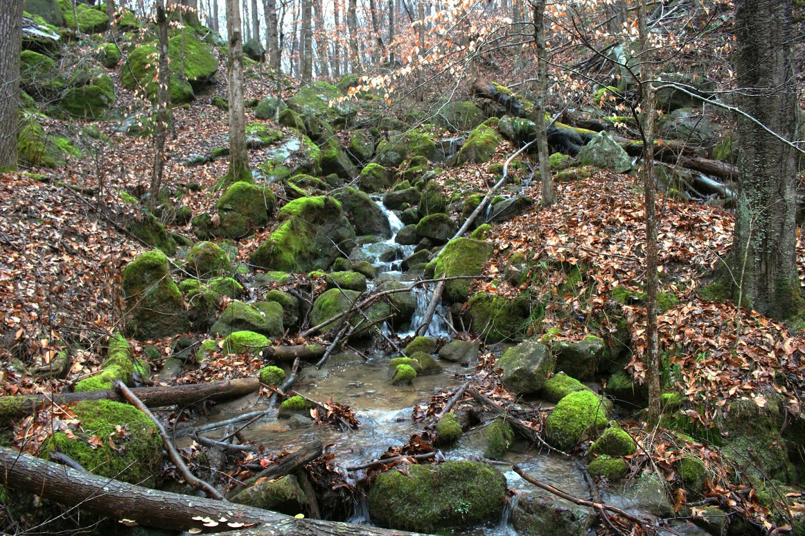
We started off wearing coats and hats. It was sunny, but in the shade with the wind blowing it was cold. We did not hike long until we were shedding layers. The trail is easy to follow and runs about 2 1/2 miles up to a forest service road and Skull Gap. Far as I know there is nothing spectacular to see at Skull Gap so this would be an out and back hike. The trail winds through a second growth forest with dead or dying hemlocks, pines, holly, poplar and gum trees. We went through at least one rhodo tunnel along the way. It is a gentle grade the entire way. The very end of the trail like the last half mile is said to be steep, but we would not see that today. I had brought along the way points for the falls because it is off the trail, only fifteen feet high, and there was supposed to be lots of underbrush to work through. The way we go stupid sometimes I decided to play it safe.
Good thing too. We hiked right past it but only by 50 feet and the entire time I was doing it I was saying "I think we're passing it. I bet that drop off over there must be it. I wonder if we were supposed to go down that drainage toward the creek." Turned out that all those things were true!
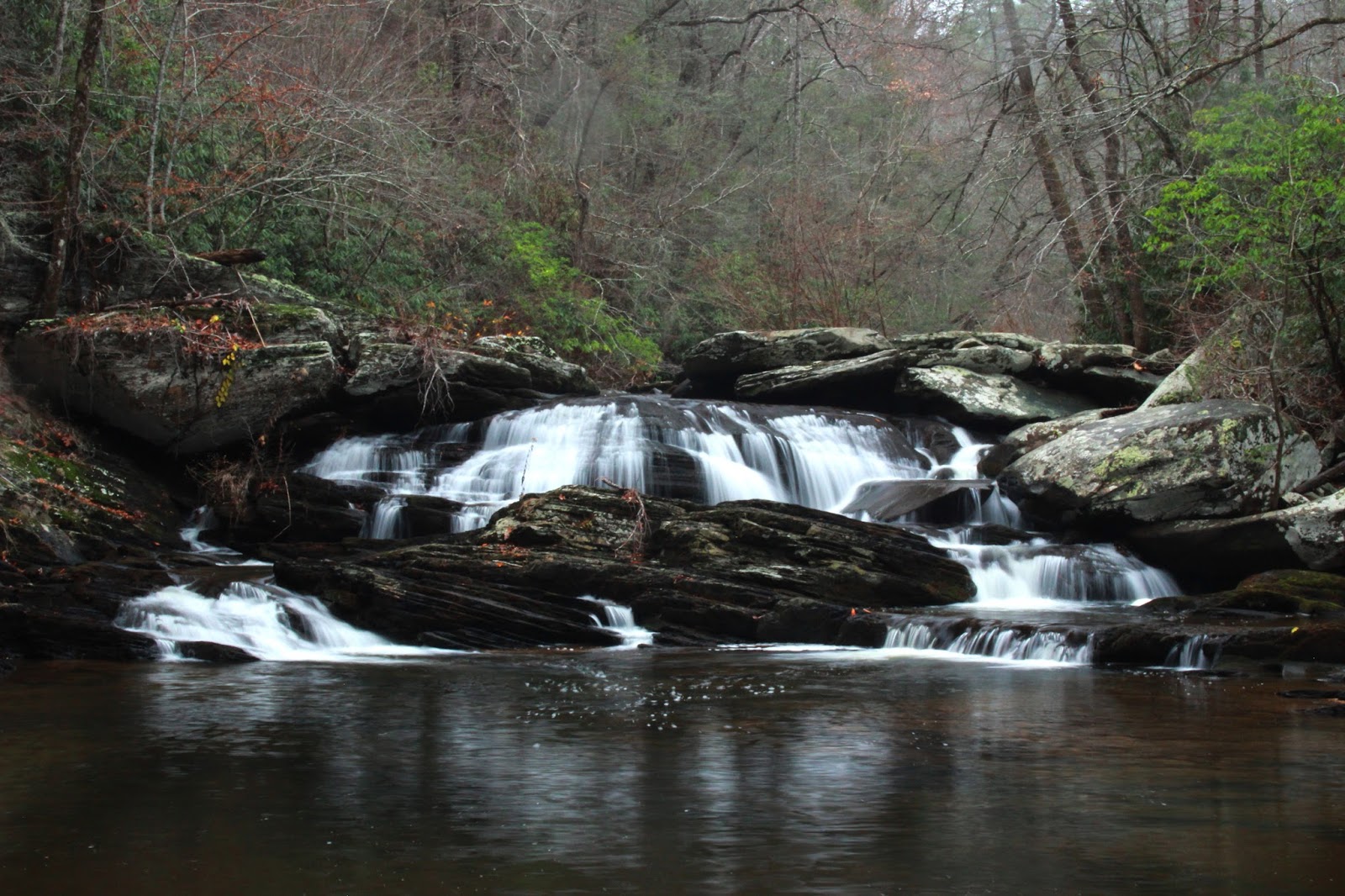
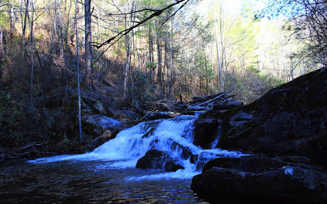
We turned around and went back to that drainage and began our short struggle through the rhodo and dog hobble. Before we could even work up a sweat or cuss we were by the creek and out of the brush into the clear. The falls is crowded by rhodo, but it is possible to get an unobstructed view of it and a good photo from the far side of the stream. All stream crossings today were easy rock hops including the one to take us to the opposite side of Panther Branch to view the falls. It sits in a rock amphitheater. It is a very shady, picturesque grotto green with moss. The sun shining down really looked nice on the water.

Panther Branch Falls from the grotto side. It would be possible to get an unobstructed frontal shot, but you'd have to stand out in the middle of the pool to get it. Too much rhodo and trees in the way.
We enjoyed the falls for awhile and turned to head back. We'd eat lunch once we got back to the car. Someone had left an old canvas lawn chair sitting by the trail. It was odd to see it there in the woods by its lonesome. We saw only one piece of litter aside from the chair. The trail is well marked and easy to follow. We made it back to the truck in forty minutes. We sat and ate and discussed what to do next. We had noticed the river was low while at the same time... the side streams were flowing fairly well. We had the notion to try to go across the river today to see them.
Long story short we chickened out. Crossing the Tellico River is not going to be easy. You will be up to your waist in water at least in most places. It will have some shallow areas on either side making it look like it could work. Closer inspection tends to show that the middle of the stream is either too deep to cross safely or the current too swift. We opted to come back after our scouting and bring inner tubes or something to make it a little safer. We nearly drowned in Little River several years ago in a kayaking accident. Neither of us is willing to be so foolish anymore. On to plan B.
Below is a short video of Panther Branch Falls.
The backup plan was to drive up North River Road and enjoy Meadow Branch Falls. It is an easy off trail waterfall. We figured we'd make it home at a decent time if we did not take too long to hike. North River Road is a beautiful drive. We saw lots of people at Bald River Falls today, but the
rest of the area was quiet. We saw few people on North River Road. We saw no one at the falls.
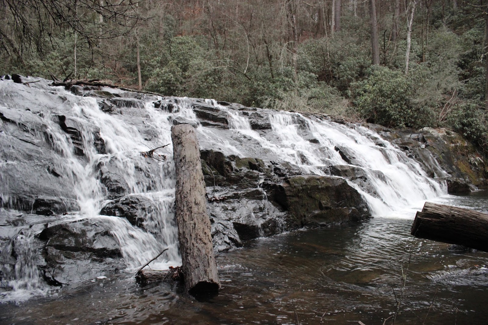
Had 'em to ourselves. We found the falls without any trouble. We climbed down over the bank to reach them. We started at the upper falls and worked our way down. The upper falls is about ten or twelve feet high. It is very scenic.

Upper Meadow Branch Falls --more water on this stream today than when we first found it. It was July then!
We noticed that Spring flowers are coming up already due to our warm Winter. Sitting here by the falls taking pictures and soaking up the scenery was lovely. It was so needed and so appreciated by both of us. Losing my life to raise a kid again at age 52 has been like a death. I have grieved the
loss of myself, and my identity. I have grieved the loss of the time with my spouse who is my lover and my best friend. Today was restorative. This weekend was restorative. It gives me hope that we'll eventually get back to how things were only better. It is on its way. Making major improvements. Hopefully by mid Spring I'll be all the way back.
We went on down to the main falls. The woods here are a gentle grade in most places and open.
We followed a drainage down toward the base of the main falls. You have to hang onto rhodo and trees and roots to get down. It is not that bad. It would not be a good one for little kids. Short distance, but slick and no real trail to the base. We got to the bottom and the spray from the falls was so strong we had to back off immediately for a spot to view the falls and get pictures. It was rocky, but easy and there was a great vantage in the middle of the stream. I looked up and saw a log over our heads like a bridge!
 Log overhead with the sun peeping in

We enjoyed the falls for awhile and turned to head back. We'd eat lunch once we got back to the car. Someone had left an old canvas lawn chair sitting by the trail. It was odd to see it there in the woods by its lonesome. We saw only one piece of litter aside from the chair. The trail is well marked and easy to follow. We made it back to the truck in forty minutes. We sat and ate and discussed what to do next. We had noticed the river was low while at the same time... the side streams were flowing fairly well. We had the notion to try to go across the river today to see them.
Long story short we chickened out. Crossing the Tellico River is not going to be easy. You will be up to your waist in water at least in most places. It will have some shallow areas on either side making it look like it could work. Closer inspection tends to show that the middle of the stream is either too deep to cross safely or the current too swift. We opted to come back after our scouting and bring inner tubes or something to make it a little safer. We nearly drowned in Little River several years ago in a kayaking accident. Neither of us is willing to be so foolish anymore. On to plan B.
Below is a short video of Panther Branch Falls.
The backup plan was to drive up North River Road and enjoy Meadow Branch Falls. It is an easy off trail waterfall. We figured we'd make it home at a decent time if we did not take too long to hike. North River Road is a beautiful drive. We saw lots of people at Bald River Falls today, but the
rest of the area was quiet. We saw few people on North River Road. We saw no one at the falls.
Had 'em to ourselves. We found the falls without any trouble. We climbed down over the bank to reach them. We started at the upper falls and worked our way down. The upper falls is about ten or twelve feet high. It is very scenic.
Upper Meadow Branch Falls --more water on this stream today than when we first found it. It was July then!
We noticed that Spring flowers are coming up already due to our warm Winter. Sitting here by the falls taking pictures and soaking up the scenery was lovely. It was so needed and so appreciated by both of us. Losing my life to raise a kid again at age 52 has been like a death. I have grieved the
loss of myself, and my identity. I have grieved the loss of the time with my spouse who is my lover and my best friend. Today was restorative. This weekend was restorative. It gives me hope that we'll eventually get back to how things were only better. It is on its way. Making major improvements. Hopefully by mid Spring I'll be all the way back.
We went on down to the main falls. The woods here are a gentle grade in most places and open.
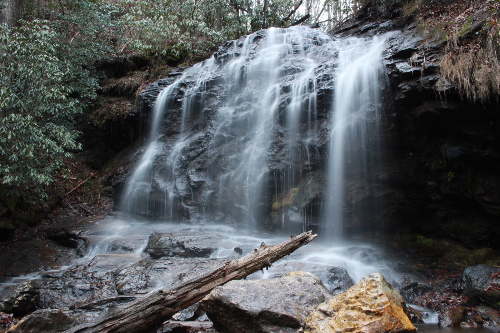
We followed a drainage down toward the base of the main falls. You have to hang onto rhodo and trees and roots to get down. It is not that bad. It would not be a good one for little kids. Short distance, but slick and no real trail to the base. We got to the bottom and the spray from the falls was so strong we had to back off immediately for a spot to view the falls and get pictures. It was rocky, but easy and there was a great vantage in the middle of the stream. I looked up and saw a log over our heads like a bridge!


Meadow Branch flowing on down the mountain


Meadow Branch Falls is a great waterfall and is 25 feet high.
Looking great today!
We were in great spirits. I had put my camera away, but got it back out to get photos of the brink of the main falls. It was good to see it from here. While I put the camera equipment away for the second time Kenny climbed back out there and took pictures with his cell phone. He then goosed me.
I usually find that sort of thing funny being the pervert that I am, but I do not think the brink of a waterfall is the best place to goose your wife. Unless you're trying to kill her. I took my ghetto booty and started the climb back up the bank to the jeep. It seemed like no time and we were back at the vehicle. The drive home would be the worst part of today. Hard to sit still. Kenny wanted to try to get out up top and take the Skyway back. I told him I had read that the road coming out of Swan Meadows is gated until sometime in March. Rather than risk driving all that way only to be turned around and sent back... we just returned the way we had come. I did not mind since it gave me a chance to stop once more and get a photo and video footage of a beautiful cascade along North River. I was growing tired and the day was winding down. Time to go back to the real world. Its ok though. I found the old me and she's still there in the woods waiting for me to come out and play.
Looking great today!
We again soaked up the beauty of the falls and wallered in the chance to be out and free. Taking photos and soaking up negative waterfall ions. Our mood was very mellow and happy when we finally climbed back up the bank toward the jeep. Climbing back up was easier than scooting down.
Meadow Branch Falls has a beautiful series of stairstep cascades between the upper and lower drops. I cannot see any way to get all of it in the photo except drone footage. We walked over to the brink of the main falls to view the stairstep cascades. They were really something to see today. We took plenty of time experimenting with the wide angle lens. I can tell my photography skills have suffered the lack of use. I am out of practice. Below is a photo of the best silky shot I got of those cascades. It was taken with the wide angle lens. It seems to cause some vignetting of the frame!
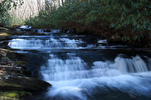
Meadow Branch Falls has a beautiful series of stairstep cascades between the upper and lower drops. I cannot see any way to get all of it in the photo except drone footage. We walked over to the brink of the main falls to view the stairstep cascades. They were really something to see today. We took plenty of time experimenting with the wide angle lens. I can tell my photography skills have suffered the lack of use. I am out of practice. Below is a photo of the best silky shot I got of those cascades. It was taken with the wide angle lens. It seems to cause some vignetting of the frame!

We were in great spirits. I had put my camera away, but got it back out to get photos of the brink of the main falls. It was good to see it from here. While I put the camera equipment away for the second time Kenny climbed back out there and took pictures with his cell phone. He then goosed me.
I usually find that sort of thing funny being the pervert that I am, but I do not think the brink of a waterfall is the best place to goose your wife. Unless you're trying to kill her. I took my ghetto booty and started the climb back up the bank to the jeep. It seemed like no time and we were back at the vehicle. The drive home would be the worst part of today. Hard to sit still. Kenny wanted to try to get out up top and take the Skyway back. I told him I had read that the road coming out of Swan Meadows is gated until sometime in March. Rather than risk driving all that way only to be turned around and sent back... we just returned the way we had come. I did not mind since it gave me a chance to stop once more and get a photo and video footage of a beautiful cascade along North River. I was growing tired and the day was winding down. Time to go back to the real world. Its ok though. I found the old me and she's still there in the woods waiting for me to come out and play.

Cascade on North River. It is only about 10 feet high. Still pretty. Has a nice deep hole of water in front of it. I have gone skinny dipping in this pool of water in Summer. Very refreshing. Below is a short clip of this falls. It is a good spot in the gloaming.
Below is a video of Meadow Branch Falls. I did not hear any curse words come out of Kenny's mouth today so I left the sound on this one natural. My hyena laugh is on there at the start, but I don't care.
**Edited to Add** Note to Self-- We need to rent the Donley Cabin one night and stay there in the area. Maybe two nights. More to explore in the vicinity. Remember to check your list.