
Calderwood Lake Tunnel Trip & Parsons Branch Falls Directions
by Dana Koogler 8/17/2024
The directions contained here are to help people find the put in for boats as well as enjoy the high points along Calderwood Lake. The spots mentioned are just the ones I am aware of, but there may be more.
Driving Directions to Magazine Branch Boat Ramp
From the Intersection of SR 28 and Hwy 129 at Deals Gap, NC
Turn south onto Hwy 129 from Deals Gap and follow it toward Cheoah Dam.
Continue south on Hwy 129 for 2 miles passing Cheoah Dam on your left.
Just before the bridge where Hwy 129 passes between Cheoah Dam on your left and Calderwood Lake on your right there is a dirt road. Turn RIGHT onto this dirt road. It is listed as "River Road" on Google Maps. It dead ends and is the access for the Magazine Branch Boat Ramp.
There are several put ins at this location. River Road dead ends at a picnic table.
There are restrooms here, boating access, primitive camping, picnic tables, parking and trash receptacles.
Park and put your craft into Calderwood Lake.
Below I have included a Google Map showing the location of the boat access.
Below is a photo of one of the boating access points at Magazine Branch.

I am including the points of interest in the order you will come to them if paddling the lake.
Slick Rock Creek
Slick Rock Creek flows out of Joyce Kilmer-Slickrock Wilderness acting as the boundary line between the states of North Carolina and Tennessee. It empties into the Little Tennessee River which is now Calderwood Lake since the dam project. It is a clear, beautiful mountain stream with exceptional scenery and at least two significant waterfalls along it.
It is the first point of interest on a paddle trip leaving Magazine Branch boat ramp heading west along the lake. Campsite #1 is situated along its banks on the left where it joins the lake.
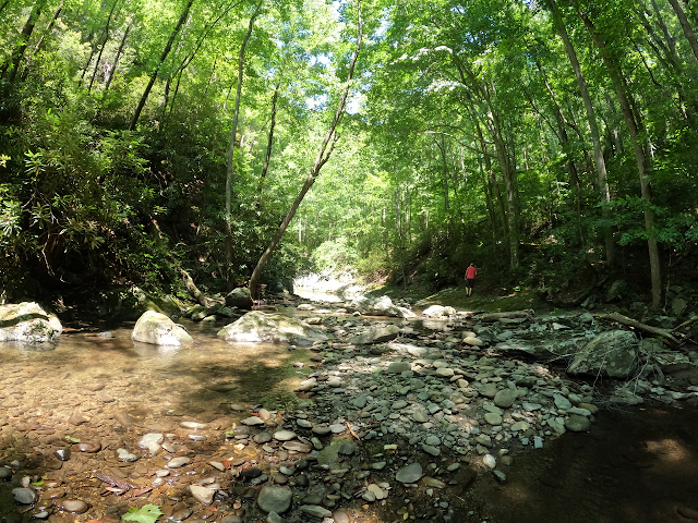
The water here is exceptionally clear and it is a good swimming spot. A small cascade can be seen from the lake. It shortens the normally six mile round trip hike to Lower Falls down to 2 miles round trip by putting you out just below the trail. It is possible to pick up the trail just above where you beach your water craft and hike from there.
Below is a map of the falls in relation to the boat ramp.
Below is an image of Lower Falls

Below is a photo of Kenny beaching one of our kayaks to start our hike. Look at that clear water!

Calderwood Lake Train Tunnel
The dam building at Cheoah and Calderwood and beyond required supplies. At some point in the construction period a supply line was built via train to speed up the process. Once the dam was complete the lakes flooded the Little Tennessee River out of existence. It also flooded the train tracks along the way. It is possible if you plan your trip right to find and paddle through the old abandoned train tunnel.
The waypoint for the tunnel is 35.47685 -83.95171
Directions: From Magazine Branch boat access it is 2.50 miles west along the lake to the tunnel on the RIGHT shore. It cuts through a point of land jutting out. It would be easy to go right by it if you weren't aware of it. If you are hunting it and have a general idea where to look finding it is not so hard.
We made the mistake of taking a CANOE. Water levels were too high and we were sitting too high in the water to go through it. We will have to return when water levels are pulled down in Fall and when Santeetlah dam is NOT releasing water. Be careful as the water levels on the lake can rise by several feet in a short time when they are releasing water.
Below: a photo of the train tunnel on the east end of it.

Parsons Branch Falls

Below: the pull up area for Parsons Branch is like this only there is a bit of mud too at the beginning.
Directions:
Continue down the lake from the tunnel another 1.30 miles to the first big cove on the RIGHT.
This is Parsons Branch. Paddle up and beach your water craft or anchor it... and start the short walk to the falls. The un-numbered campsite here sits on the RIGHT heading upstream. The falls has a trail to it just past the camp. The waypoint for the falls is 35.492914,-83.937920
Notes: We returned and the lake had risen about two feet. The water was choppy on the way back. Water was being released and the current was a lot stronger on the return trip.
It is worth mentioning that while this is as far as we went it is another 4 miles west/southwest to the Calderwood Dam. Far as I know there is no way back out from there so you must return the way you came. Stay well back from the dam itself.
Also the next cove to the RIGHT is Shaw Grave Branch. It looks to be a good sized stream with topography that presents the possibility of another falls. It is worth investigating especially during times of good rain fall. It is another 1.30 miles down from Parsons Branch.
No comments:
Post a Comment
Thanks for reading and commenting. I enjoy hearing from those who read & make use of my blog. I have made some wonderful friendships through emails from readers. I respond to all comments and emails. I appreciate folks reaching out to let me know when my blog entries are not functioning correctly or if the situation somewhere has changed. Many Blessings to you!
Dana 🐝