The original plan for this trip was to stay at the new Watts Barr Jellystone Campground. We were going to enjoy the waterpark, swimming pool, and go boating on the lake. I had been suffering with a persistent cough for a month. I went to the doctor June 12. I got treated with prednisone.
I was back for a yearly physical June 18 and a recheck. I wasn't better. I was given antibiotic.
I was back again Thursday June 19th for having worsened. Finally out of exhaustion and the need for a good rest I stayed home. The rest of the family went ahead. It was an hour or less away.
I spent the time resting in bed, on the couch and stayed inside. I stayed out of the heat and allergens.
I was told I will have to see a lung specialist now since the condition did not respond to prednisone.
I had a lonely, but restful couple days at home. Finally on Saturday I was feeling some better.
I went and had a mani pedi which helped me cheer up a bit. I saw a mouse in the hallway on my way to the nail salon. I chased it with the cats. I tried to whip it with a broom. It only made things worse as it ran into my bedroom. I called Kenny and made arrangements for him to come get me. I would not have to face sleeping in that house with a mouse on the loose!
I joked and told friend Phil that I signed the deed to the house over to the rat and left!
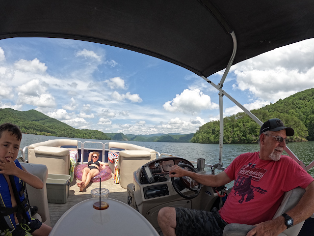
I spent Saturday and Sunday night at the campground in Loudon with Kenny and my family.
I didn't do anything on Saturday as it was late, but we did get out on the lake on Sunday. I had never been boating or swimming on Watts Barr Lake before. It didn't seem too appealing at first. It ended up being better than anticipated. We saw lots of wildlife and had a great time.
We saw gar fish, bass jumping, a bald eagle, cormorants, wood ducks, ospreys, and one black cow!
The water was perfect on a hot 95 degree day in the blazing sun. I am loving our pontoon boat which can hold 13 people! We had packed sunscreen, toys, lunch, snacks and plenty to drink. We spent a lot of the time swimming in an out of the way cove. Floating on tubes. Towing the tube behind the boat. It was exactly what I needed. It was relaxing! I was outside finally, but avoiding the heat and excessive pollen. I learned my lesson too. I had insisted on mowing our son Jared's lawn. I felt Kenny was treating me like I didn't know how to do anything. It never occurred to me he was trying to take care of me and protect me against dust and anything that might set off my lungs. All that grass and dust didn't cause the problem, but it sure didn't improve the situation. I won't be mowing anymore.
We went to Calhoun's on the river in Lenoir City for dinner which was nice too.
I got down to the campground Saturday evening just before supper. Operation Midnight Hammer went down around that time. It was on the news regarding the bombing of three nuclear sites in Iran by US by B-2 stealth bombers and a coordinated strike by our navy using tomahawk missiles. My son in law is military and filled us in that Iran was less than a month away from having a nuke. I can't think of anything much worse than that for our world. I saw a video from 1979 Iran and how they have gone away backward since then especially regarding women's rights. I pray the Lord will come on back soon as this world is far too crazy for me these days.
Below: left to right Michael, Adam, Tessa and Crystal. Kids napping on their daddy.
Below: some sort of st johns wort blooming on the shore of the cove.
Below: in the distance the Kingston Steam plant. This section of the lake was pretty, but full of debris in the form of wood.
above: 16 year old grandson Michael in the tube
Above: a better photo of the pretty cove where we went to get away from the boating crowd.
Above: Papaw Kenny and our family
Above: trumpet vine close up. One of a few Summer flowers we saw today.
Below: Queen Anne's Lace in bloom.
Below: a pretty view out across the lake.
Below: Monday morning dawn over the campground and water park.
Below is a video clip of towing Michael in the tube.
Kenny got an unexpected day off work on a Monday. We had yet to take the boat out on the water so it looked to be a good day to go for it. Kenny had been doing a LOT of fretting about the forecast and the rain storms. Letting it shackle our plans. I finally spoke up about it and said enough was enough. We planned to get up with our daughter Crystal, granddaughter Tessa, Tessa's friend (our friend too) Alexis. Crystal has a Honda pilot with third row seating. We would need this for today's adventure. We took two vehicles. Truck towing the boat. Dropping it off down at the lake in a parking area. We then loaded up in Crystal's car and she drove the Tail of the Dragon for the first time ever. She'd never even been on it! Who knew?!
She did a great job. No one got car sick. She had been wanting to go try eating at Tapoco Tavern so we did that today! We pulled in there and it was a wonderment to all. Kenny and I were the only ones who had been before out of this group. Our meal was great and it worked out well for everyone to be fed and have a chance to use the restroom before hitting the lake.
Crystal enjoyed it as much as I hoped. Already planning a date night to go back!
above: Gabe and Crystal
above: the Cheoah River right by the patio where we ate
Above: Left to right Mia, Alexis, and Tessa
We headed back across the Dragon to the boat ramp to begin our day on the water. We bought a nice pontoon boat late last Summer. Our granddaughter Mia was not sure about this whole boat ride business. She was nervous starting out. She quickly relaxed and enjoyed the ride.
I had the GPS along and wanted to check the waterfalls that are supposed to be dropping into the lake. We checked them today, but found only one barely trickling even as much rain as we've had. I am done looking for these. I know Lawson Hollow runs and is beautiful during times of heavy rain, but the rest... you can keep them.
We went down toward the campsite near McMurray Cemetery Citico. Families were camped there and having a good time in the water. The beach such as it is.. is red mud. We didn't care. We jumped on in. Even Mia jumped in and was loving it. The water was cool in spots but closer to the surface was quite warm. We swam around a good bit, but then the kids were ready to go for a ride on the tube Papaw bought.
Above: This is how Calderwood Lake looked today. Not an uncommon sight. Advection fog on the surface. We stopped by Magazine Boat ramp to see how it would work out with our pontoon for future trips.
Below: It's Mimosa time in Tennessee! These are non-native invasive, but they are pretty, tropical, and smell like the very breath of Heaven. These were near the put in ramp.
Above: Kenny backing the truck up and loading up the boat!
Below: Kids in the lake in that muddy water. We don't even care! Mia was unfazed!
Above; More scenes from swimming
Above: the red dirt beach at Citico
Above: Capn' Papaw sure knows how to have a good time! We love him like crazy. Crystal is talking to him about something.
Below is a short video clip of swimming today
Eventually we climbed back on the boat and Kenny started getting the tube ready to launch! I'd be the observer for the first round. The business of "towing without an observer" really isn't a joke. A mirror helps, but an observer is better. Last Summer my son in law, Adam, saved a child who was involved in a tubing accident. I won't get into the details, but it could have ended badly. The family was watching, but things sometimes still go wrong. Need to be paying attention.
Below: Alexis and Tessa went first.
Below: hard to see them back there. The clouds were especially pretty today!
Below: Crystal stands in front of the tube before it is unloaded.
Below: Tessa, Alexis and Mia and Crystal's belly in her sparkle tube!
Below: Kenny is piloting the boat while we tow the kids. Crystal lounging and Gabe looks on.
Below: towing Gabe and Mia
Below: Gabe and Mia in the tube but hard to see.
Everyone liked the ride in the tube. Each kid had their own likes and dislikes so they paired up accordingly. Gabe and Alexis like fast and furious. Mia and Tessa like slower and steady. It worked out great.
The day was getting late. No one was wanting to leave, but the dog was going to need let out at Crystal's house. Not fair to leave him so long. We should have just brought him with us.
We stopped one more time to swim and play not far from the dock. The kids were NOT ready to leave, but I could tell they were getting tired.
Below: my favorite view of the Smoky Mountains today across the lake!
We finally had to pull in to the dock and Crystal and her girls went on ahead to let Rip out.
We Kooglers stuck around to pack the truck and hook up the boat. I don't think we were even on Foothills Parkway yet when both Gabe and Mia were snoring like two little squirrels. That is a win for the grandparents! It was a perfect day. No weather problems. We had one little sprinkle while over at Tapoco and that was that!
Below: Gabe and Mia napping in the truck from having played very hard! They are getting so big.
Below is a video of towing the kids:
Below is the promised guest author short story by James Buchanan. He grew up at Scona and what adventures he had. I'm sure he'd have liked all the things we did today when he was a kid, but he took the party with him where he went. He did some REAL living. Thank you Jim for another adventure shared!
My daughter Crystal is a teacher and has the Summer off with the students. We talked it over and decided we wanted to take a trip up to Frozen Head State Park. We'd take the kiddos and let them play in the creek. My original plan was to have a picnic out there, but we opted to have lunch in Chik-Fil-A
in Oak Ridge instead. The kids enjoyed the food and the play land. Once that was finished we headed on out the road to the state park. We always enjoy it. Today would be Mia's first time there and her first time at a waterfall!
We arrived finding very few vehicles around. We were able to park right at the trailhead.
We gathered up our drinks and creek toys and started our hike. The little ones noticed a pretty hole of water right past the gate. We stopped there first to let them go ahead and play.
Above: My daughter Crystal looks on as Mia age 4 wades right in.
Below: Gabe is a little more cautious
Below: some of the pretty things we saw were wildflowers.. the one below is Virginia spiderwort
and below is a pair of Eastern Tiger Swallowtail butterflies. Tessa was able to pick one up and hold it a moment before it flew.
Below: Granddaughter Tessa age 12 with her hat on backwards. Crystal and Gabe.
The kids remembered we were supposed to be hiking to the waterfall so we soldiered on!
It is a super short, easy hike which is nice especially for taking along a four year old who isn't used to hiking. Mia never complained or slowed down the entire time! She was full of energy and all about it!
We saw a few other hikers, but most were coming back toward us.
We soon crested the little knoll where you turn to go over to Debord Falls. Tessa and Gabe remembered it from a couple other visits. We turned right and headed toward the steps.
The steps are impressive and newly done.
Below is the beautiful Debord Falls in good Summer flow!
Below: Mia and Tessa are checking out a crawdad in the net. Nanny had to catch him. I'm still the expert. The kids forget that crawdads go BACKWARDS away from you.
Below: Gabriel has been dunking his head in the falls and the creek. He reminded me at one point for the world... of John Quillen. LOL
Below: a look at the crawdad who had only one claw! Nanny picked him up but nobody else wanted to hold him.
above and below: Tessa is on the hunt for critters!
Below: Gabe and Mia
The kids had a great time splashing around and catching butterflies, crawdads, minnows in the creek.
Once they had their fill of that we took them to the playground in the state park. They had a great time making friends with other kids and playing together. Mia mastered the skill of going down the fireman's pole part of the playset. I had to help her the first time, but after that she was good to go!
above and below: Gabe and Tessa on the playset
The kids were great and it was a bluebird day. Perfect weather. No problems. All went to plan.
Finally we persuaded them it was time to head home. They were tired especially Mia. She was asleep shortly after we pulled out on the road. We made a stop in Oak Ridge for Crystal and Tessa to go in the book store. The rest of us waited in the car while Mia napped. We thought we wanted icecream, but everyone was worn out and just ready to go home. The only minor snag we hit was trying to leave Oak Ridge during rush hour! Kenny was somewhere caught in it too. No matter. We had a great day and made it home safely.
Below is a video of the playing in the creek part of our day.
We originally planned to take the pontoon boat out on the lake on Saturday. I was disgusted that we hadn't even had it out this season. The problem was that the excessive rain had the lawn like a sponge.
Not wanting to tear the yard up or get stuck moving the boat right now was a bad idea. I didn't care after my visit at the Morgan County Heritage Museum Thursday. Reading my new book about Gobey had me intrigued and I was keen to do something different. I suggested to Kenny that we take the RZR and go exploring at Gobey. He jumped at the chance! We were both excited about the prospects.
We knew the rain would have the rivers and waterfalls running very well. Kenny got out Lifetime Maps on the tablet and we found out that an overlook we wanted to see was on there! We'd finally go see Brain Rock and try a new trail. We could also visit the Pilot Mountain Fire Tower at last. It was one of those places we'd talked to death, but never ventured. Today we'd fix all that.
I have found that my lack of energy has caused me to rethink some of my elaborate plans and schemes. I had planned on fixing a steak dinner and packing us a picnic for the next day on the trail.
I realized I am my own worst enemy. I make my life complicated with all these plans. Why work so hard, go to such trouble and expense and time to prepare a meal that takes minutes to consume?
Nope. Today work smarter, not harder. I figured out a dinner solution that could double as lunch solution for the next day. Much more efficient and thrifty as well. Adversity and struggle are making me re-evaluate many aspects of my life. Pay attention to that comment as it is going to be on the quiz later! 😁 Much to Kenny Koogler's chagrin!
We parked at Elizabeth Church today since it was handy to our starting point. We started off at Greasy Creek and went up from there. The ride to Brain Rock was pretty and seemed pretty short and straight forward.
Below: Elizabeth Church. One of four churches originally at Gobey. It is one of only two that remain.
Below is a view of Pilot Mountain in the distance from Brain Rock.
Below: the surface of Brain Rock is where it gets its name.
Below: mountain laurel was in bloom today in many spots including at Brain Rock.
Below is a video clip from Brain Rock Overlook
We enjoyed the overlook tremendously. It felt good to have finally found it. It was much easier than I expected. Lifetime Maps to the rescue! We moved onward to our next spot. Kenny wanted to go to the waterfalls next. I said no because we had already seen them several times. I wanted to stick to the plan of visiting Pilot Mountain Lookout Tower. He conceded the point and on we went. It was a fateful and fortunate decision. I was batting a thousand today!
I had watched videos that mentioned Rock Ledges Trail as well as Brain Rock. I was intrigued by the rock ledges aspect more than anything. I have ridden parts of Gobey that were strange, convoluted and fun. They are paths that were left over from former coal mining days. Today would be another adventure experiencing those old paths. What I was discouraged by on all these videos is that most of them failed to show the mentioned feature. Brain Rock was shown, but the Rock Ledges trail really wasn't. I wasn't able to find a single photo or video that truly showed Pilot Mountain Lookout Tower. It only showed the trails which all began to look the same.
We continued our ride watching Lifetime Maps as we went. It really helped us pick our route and what was out there to see. The Rock Ledges trail was an instant favorite with us. The scenery is beautiful and dramatic, and the ride was a challenge. You wind along just beneath the level of impressive rock ledges on the sides of the trail. Not one area is like another. It is continually changing.
All of it is beautiful. We saw a surprising amount of wildflowers in bloom for this time of year!
Below are several shots of the various rock ledges.
The woods were in leaf out, but you could still see a lot today. We saw flame azaleas, butterflies, a hawk, a scarlet tanager, frogs, tadpoles, dragonflies, and many other beautiful things. Indian pinkroot was thick today though most were just starting to open. The tiny bright red spires were popping up all along the forest floor. We saw two flowered cynthia, fire pinks, daisies, rock lilies, multiflora rose, Cherokee roses, and Seven Sisters Roses in pale pink, hot pink, and red! Day lilies were abundant along the roads and trails.
Below: this ox eye daisy is odd looking with its narrow pointy petals
Below: multiflora rose in a deeper pink than I am used to seeing.
above: first sighting this year of flame azaleas in a deep red orange
Above: Virginia spiderwort just opening up
Below: Indian Pink root
Below: two flower cynthia one of the blooms is very droopy
One of the most exciting spots along this trail today was when we came to a spot with a drop off and a badly eroded ditch on the left... a deep tailings pond on the right and the trail on a narrow slope right between them. I was tempted to get out of the machine, but Kenny got out and checked it saying "oh this won't be bad." and so I rode it out. He made it look easy. It had some pucker factor though!
We came to a place that the map called Knolling Knob. It was a steep climb on the trail up to a nice flat area in the forest. I had brought the backpacking stove and equipment to fix us a hot lunch. We warmed up sloppy joes on the trail and even toasted the buns in another pot. It was better than a cold sandwich and was nice and quick. We were able to clean things up and get going again in short order.
I noticed someone had discarded bags from those bagged cocktails and the containers from jello shots.
Apparently trail drinking makes it just too hard to care about picking up ones mess.
This is a good time to share the elevation profile Kenny showed me when we were home again!
Below: elevation track on Lifetime Maps from start to finish. Start on the left.. finish on the right. whew! Little by little we're learning to use the features on Lifetime Maps. It tickled me pink to be the one who knew how to fix it when Kenny messed it up and lost our tracks. I also learned to save a track. We found the compass and GPS feature on it as well.
The section of trail immediately after Brain Rock was very muddy. It reminded us of the Water Trail at Turley. It is now closed by the TWRA.
The next really fun and tricky spot was a place on Rock Ledges trail that was three or four deep mud holes one right after the other. There was a work around, but it was sketchy sitting off camber. After some ciphering things out and testing the depth and firmness of the bottom of the mudholes it was decided to go on through them. Below is a video of that process.
We successfully made it through that stretch of trail and swung around the next section. We could see a mountain off in the distance that was like a very pointy triangle. It was Peak Mountain. We passed over Young Mountain and came to a spot under the rock ledges where the map indicated "Draft Dodger Cave" this has to be Boog's Den. I read about it in my new Gobey book I bought on Thursday. We decided to tackle that in cold weather as snakes are out now. It involves climbing around in the rocks to locate it. I have seen a photo of it so maybe we can find it. We will try again this Winter.
The next section was a kiss your butt turn that took us to The Crosses. I don't know if the people were buried there, ashes scattered there, died there or what , but there are three crosses at this spot.
It has the deceased names on each one. It is a pretty spot with a partial view.
above and below: three crosses Braxton Shannon, Michael Love and Wormey Bales.
Below: this is part of the Kiss your butt turn!
above: an interesting and wide open forest in one spot along our trip.
Below: One of many downed, massive white oak trees today. We saw three fallen white oaks. It was like the ENT grave yard. Very sad.
Above: grassy path along Peak Mountain heading to Pilot Mtn. Below is a photo of the tailings pond that sat to the right of a narrow place where we had a drop off on the LEFT....
Below is a closer view of the tailings pond and if you look closely it is full of half grown tadpoles turning into frogs!
Above: a pretty stretch on the trail with another huge boulder on the left.
Once we approached Peak Mountain we encountered part of the trail tightly encroached with vegetation on all sides. We had a slope below us and a slope above us. We ran into another mess with two downed trees and the tops of them were what crossed the trail. Kenny opted to take the work around rather than spend time clearing this tangle. He backed us up and we hit the work around. About that time here came several machines UP the trail. Thankfully we had room to pull over and let them pass. It was three couples riding side by sides. They were the only folks we saw all day.
We wound up and down and continued in a counter clockwise direction until we were nearing Peak Mountain. The trail doesn't cross the summit, but goes around the shoulder of the mountain. It was a very pretty part of the ride with partial views for much of the way. One part of Rock Ledges Trail is a knife edge where you can easily see from one side of the ridge to the other with a long way down on either side. The Peak Mountain section was nice. It had more interesting rock forms, flowers, and views.
Below are some fire pinks I saw on Peak Mountain
Below: Eastern Tiger swallowtail butterfly on flame azaleas on Peak Mountain
Below: another flame azalea shrub on Peak Mountain. You can see the lichen covered rocks that were strewn on the upslope.
Below: Peak Mountain trail
Below: view from Peak Mountain Trail
Below: looking ahead on Peak Mtn Trail
Below: elderflower with a meadow frittliary butterfly
Below is a view from Peak Mountain of approaching Pilot Mountain I think.
Below is a video of the view from Peak Mountain
We continued onward toward Pilot Mountain. It helps to be able to see on the map track how close you are getting not to mention which turn to take. We found the trail up to Pilot Mountain summit to be in good condition most of the way. Coming off was pretty, but another matter. It was rougher and more eroded. We arrived atop the mountain and found the antennas and the fire tower. The tower is in bad shape. Most of the steps are missing and it is fenced inside an enclosure. The summit is flat and you still have partial views. No wonder we don't see videos of it or photos. It isn't much as lookout towers go. It was still satisfying to visit. I walked down the slope to see fire pinks growing in an old stump!
Below: partial views from the summit of Pilot Mountain. Just beginning leaf out here!
Below: looking up at Pilot Mountain Fire Tower
Below: a zoomed in view of the cab
Below: fire pinks growing in an old stump down the slope from the tower
Below is a short video clip of the fire tower and the summit. I actually show the tower.
We took time to get a drink at the summit and motored onward. We'd head back toward the Elizabeth Church and then on up into Gobey toward the waterfalls. The ride down to the church was pretty, but rutted. We passed several ponds and small streams. The forest we passed through was largely hemlock and loblolly pines. The pines were clearly planted as they were all in straight rows.
We came down through a small residential area and eventually passed the Caney Creek Church where they had some kind of doings. Maybe Vacation Bible School as a lot of churches are doing that this time of year. They had a good crowd!
Once we passed the truck we stopped by the bridge for me to get some photos of the roses and the river. The Emory River this time of year is jade green and this year is full of water! It can get pretty shallow in Summer. That is more usual.
Below: shimmering waters of the Emory River near the bridge. The ruins of the lumber mill are in the forest just out of sight at this spot.
Below: a mass of seven sisters roses covering an old rotting log at the bridge
We passed the first gate up Gobey along Macedonia Road. The next left took us to the turn for Gabriel Falls. We visited that first. We could hear it from the road easily. We went up past it, turned around and came back down to it. We got out and bushwhacked carefully from the road to the creek. We had our eyes peeled for snakes. Thankfully we didn't see a one. It was brushy and briary to reach the falls, but it was a short bushwhack. We followed a rugged old road bed to it on the far side of the stream. It was not easy, but it was possible. Kenny slipped and busted his butt on the way. That is usually my job, but I was very, very careful today. We had to then cross back over to reach the falls from here. They were running real good and it was worth the effort to see them today. There is a small lower cascade just a few feet high, but real pretty.
Below: Gabriel Falls in good Summer flow
Below: the lower cascade of Gabriel Falls
Above: Gabriel Falls from further downstream. It gives you an idea of the terrain. It is steep sided all around it.
Below: closer view of the lower cascade
Above: Looking up at the sun around 3:30 pm. I read in the Gobey book that the sun didn't come up until 10 am or so and went down around 3 pm. I'd say this was owing to the terrain and the dense forest cover!
I made an offhand remark something to the effect that "It isn't that high up to the road. It is a shame there is no way to reach it from here." That was like waving a red flag in front of a bull for Kenny. He waded into the brush over there with those tall snake stomper boots on. He yelled for me to come on over there. I asked him WHY? to which he responded there was a good photo to be taken from that spot.
It was then I had an epiphany. The lightbulb came on over my head and I realized he was lying to me.
I had two logs over the front of the falls where I was directly in front of it. Over on that side they'd be even more of an obstruction. Not to mention the rhodo in the way! I told him NO! He then had to say the truth. "Come on over here and I can help you get up to the road easier than the way we came."
Now I KNEW he was laying it on thick. He was trying his darndest to get me into a fix with him.
Nope. Not today hoss. I refused and the crest fallen look on his face was priceless. Why oh why have I failed to realize this all those years before? He is a shyster. Trying to trick me into trouble. Lead me not into temptation. I can find it myself! I told him to go ahead and do what he wanted, but I was going back the way I'd come. He came trotting back. Part of the walk back was listening to him Man Splain to me how he was going to hoist me up and put my butt on his shoulders and heft me onto the road. Sheesh. He was REALLY disappointed which made me even more tickled that I didn't fall for it. It seems old age is smartening me up to his treachery!
Below is a video of Gabriel Falls
Next we went to Atlas Falls which was a short distance up the road. It was running really well also.
It is a short walk down over the embankment, but it is clear folks are riding right down to it. Kenny opines that he bets folks are trying to climb it with the machines. He might be right, but I doubt it.
I was growing tired and about ready to head home. We enjoyed a brief visit at Atlas Falls before we went back to the truck.
Below: Kenny in the snake boots at Atlas Falls
Below is a video of Atlas Falls from today.
We made it back to the truck around 5:30 p.m. We loaded up and got going. We agreed to stop by Buddy's Barbecue in Oak Ridge for supper. I am tired of cooking lately. Cooking generates a big kitchen mess and mine seems to stay messy anymore.
We had a grand day together. It was a memory maker for sure. We had so much fun and saw new terrain. We both agreed this trip makes us want to go back to Gobey next Spring to see what blooms in the new area up high? Maybe we will.
It was a perfect day with fun, adventure, beauty and romance to cap it off.


.jpg)
.jpg)


