Dry Creek Falls & Rylander Cascades Directions
Dana Koogler
Jan. 27, 2022
35.849979,-85.344960
Driving Directions:
The trailhead for Rylander Cascade/Dry Creek Falls is located along Whites Creek Road 0.25 miles south of the parking area for Lost Creek Falls.
There is parking across the road from the trailhead and room for maybe five cars. An info kiosk is almost within sight of the parking area that has a map of the trail. It is worth mentioning that this is also the route to hike to Virgin Falls via Wilson Ridge... coming in from "the bottom" of the falls instead of the usually crowded main trail up at Eastland.
It is also worth mentioning that during times of low rainfall and hot temperatures this falls dries up significantly. It could end up being a disappointment so plan accordingly.
Hiking Directions:
3 mile round trip moderate hike
Walk across Whites Cave Road to the trail and begin your hike. The trail is easy to follow and well marked. It is signed at intersections as well as still being flagged with survey tape currently. It is very rocky ground.
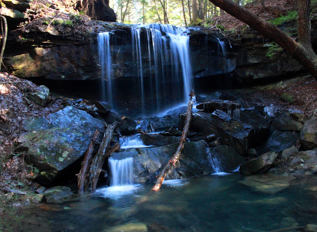
You will come to Rylander Cascade in 0.50 miles on your left. It flows out of the slope on the left side from a nice spring, forms the falls and re-enters the ground at a swallet that drinks up both Rylander Cascade's waters and the waters of Dry Creek coming down the mountain below it.
Once you have checked out the cascade continue following the trail which goes uphill now on a fairly steep grade. It has merciful spots where the ground levels off though. It is 1 mile further from Rylander Cascade to Dry Creek and Upper Dry Creek Falls. You will come to an important intersection in the trail where a right turn is signed for continuing to Virgin Falls and a LEFT turn takes you another 0.70 miles to Dry Creek Falls.
You will cross several springs that create muddy spots along your hike.
Down below you to your left you can get a view through the fairly open woods to the rock formations and cascades of Dry Creek. It is a pretty area and the scenery gets better as you go. You will come to a large cave opening on the right as you go. It is along a level stretch of trail.
The trail then trends downward toward Dry Creek whereas you have hiked above it up to this point. You will come to the stream just above a nice cascade and have to ford here to continue. It is an unbridged crossing, but even when the falls is flowing well it should be fairly simple to cross.
Rocks have been stacked here to make it a little easier.
Once across the rest of the hike is on the opposite side of the creek. No more crossings until your return hike. You wind along the stream enjoying some lovely scenery of mossy green rocks in the stream bed. You are in a pretty hemlock gorge at this point. You will come to a side stream flowing in from the left and are now within earshot of the falls.
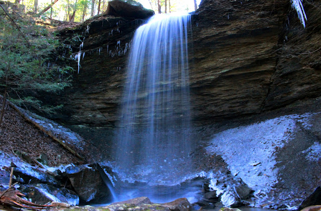
It drops over a bluff to form the falls.
Upper Dry Creek Falls is 250 feet upstream from the main falls.
You cannot see it from the base of the first falls, but back track and you will see a flagged, but unsigned path leading you up the bank to the upper falls.
It is around 15 feet high and is in a nice hemlock grotto. The plunge pool was pretty and tranquil blue when we visited. It was so clear you could see all the way to the bottom!
Return the way you came. The hike in took us 90 minutes. The hike out took 45 minutes to an hour.


Thank you for your overview of these trails. My family has lived in the other end of Hickory Valley for several decades, and now, having these new trails has been wonderful! Kudos to those who are working so hard to make the Lost Creek, Dog Cove, Dry Creek, Virgin Falls, and Old Bonair Road trails available.
ReplyDeleteThank you for reading and commenting. It is great to hear from you. You live in a beautiful area with so much natural beauty and recreation opportunities.
DeleteMy friend and I just made the hike to cylinders cascade. I am 90 and my friend is 85. The traill is rocky in some spots but very duable. Thank you for
ReplyDeleteHi Dick! Great to hear from you. Rylander Cascade is lovely. I am thrilled to have been able to assist in any way. I hope I'm still going strong at 85 and 90. That is remarkable. Fortunately we've had ample rain especially in that region so all the falls are running well. I need to take my youngest granddaughter to see Lost Creek Falls and Rylander.
ReplyDelete