
Big Piney Rock House
Friday Jan. 26, 2018
Dana & Kenny Koogler
We went over to visit with John and Sharon in Fentress County on a much needed get
away weekend. We have been going through a rough spell in our personal lives thanks to the upheaval caused by having substance abusers in the family. Relapse is part of recovery, but that doesn't mean its painless. You don't give up. You keep loving . You keep praying. You keep working the 12 steps and you keep trying. We finally made arrangements with Gabe's other
grandparents and our daughter and son in law to watch him for a weekend. It worked out great, but what we did not count on was how tired we were. We also did not count on
how after awhile the problems at home follow you. You cannot run from things forever.
You gotta talk things out and work on it.
The weekend turned out to be rainy on Sunday but the rest of the weekend was pretty fair.
We did hash out our differences and the time away from home and being with friends was good for us. Below is a quote I have in art work framed and on the wall at my house. A reminder to keep trying. Never give up.
“Come, come, whoever you are. Wanderer, worshiper, lover of leaving. It doesn't matter. Ours is not a caravan of despair. come, even if you have broken your vows a thousand times. Come, yet again , come , come.”--- Rumi
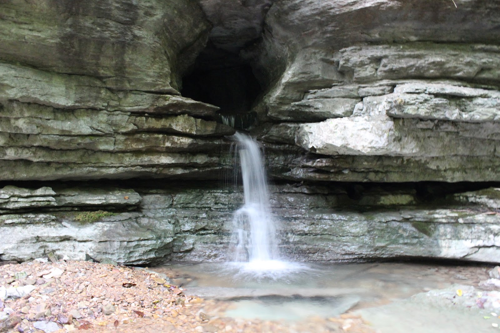
Big Piney Rock House
Friday we ended up with a few hours to do something. We needed to keep it short.
We went down into Big Piney gorge to see the massive rock house we found. We wanted to
check it out during cold weather. It is probably very snakey down in there during warm weather. We went to the Sandy side and started in. We found the trail in fair shape.
Still lots of overhanging limbs but only one fallen tree. We made it there and walked down
into the drainage and followed it back to the rock house. It was pretty cool. The late afternoon sun had the woods looking golden and smoky.


Golden sun in late afternoon woods.


Once we'd checked it out we found an easier, quicker way back to the RZR and the trail.
We went on down to the bottom of the gorge to see the creek. It was wintery and pretty.


We did a quick stop by the spot where a cemetery is supposed to be. We did not find it, but did find the remains of an old structure. We will have to try again. I have a way point for next try.
Saturday-- Trail into Lost Cane
Saturday we visited with John and Sharon a bit. They invited us to have dinner with them.
We told them what we planned to get up to and they opted out. I told them I had a feeling it might not end up being fun or a success. Unfortunately I was right.
We stopped by a house we pass sometimes on Boatland Road. I had photos of Mrs. Koger's beautiful tiger lilies I had taken one Summer when they were extremely pretty. I got prints made for her. I brought her a candle I made. We stopped for me to take them in. I met her son James and told him what I'd come for. He told me she passed away last June of cancer.
I was stunned and saddened. I expressed my sympathies and sorrow at having not made it by there in time to meet her. I left the things with him to enjoy and promised to try to be more neighborly. I went back to the RZR with Kenny and burst into tears as we pulled away.
Don't hesitate to do something nice for another, because we never know when it may be too late. Her name was Clarice Koger and she was only 72 years old. A sweet looking silver haired lady. I hate that she is gone.
We went on to Bills Creek and the upper trail on the ridge. It was open, but lots of brush to whack me in the face. We finally got on to where we'd found a side trail we believed led down off the ridge and into Lost Cane just below Frank's Flume. We pulled over and walked it.
The plan was to clear it out IF it went where we believed and IF it was not a mammoth task.
We followed the old road, but it did not end up going where we believed. It would have indeed been too much of an undertaking to clear out. We finally had to give up and go back. I was down.
I just didn't care about anything right then. I was still saddened.
We had a nice dinner with John and Sharon and lots of good conversation.
We finally headed back to the No Tell Motel as I call it.. the Jordan Motel. We slept and when we went to bed it was raining. It was to have cleared out by morning, but it didn't. We went back to Boatland to see John and Sharon and have breakfast. The day was rainy and cold and dreary.
We said our good byes and headed home.
It was good to get away, but most of our plans didn't turn out like we wanted. That is not the end of the world. When you explore sometimes you are going to get disappointed. At least we have the satisfaction of knowing what we wanted to know and can cross some things off our list.
A consolation prize was that at the start of the week a young couple reached out to me for help in finding Rainbow Falls. I ended up helping them. Friending the lady on Facebook. They are
our kinda people! I am very excited to get to meet them. They are Hippie Jack loving, music loving, outdoor loving, campers, four wheeling peeps! A second good side effect of helping them?
I found out they can help me get to see Hell Hole and possible some of the other sink holes I want to check out to wrap up my sink hole research project.
' A third great thing that happened was in studying the map for them I happened upon answers to accessing places I had wanted to reach! I also found new questions for myself to have brand new Ponders over. Julia Ross.. You know what I'm talkin' bout gurl! LOL... The studying on a thing can be nearly as much fun as finally figuring it out!


