Showing posts with label history. Show all posts

Wednesday, August 26, 2020

Museum of Appalachia Visit & Bluebird Fire Tower

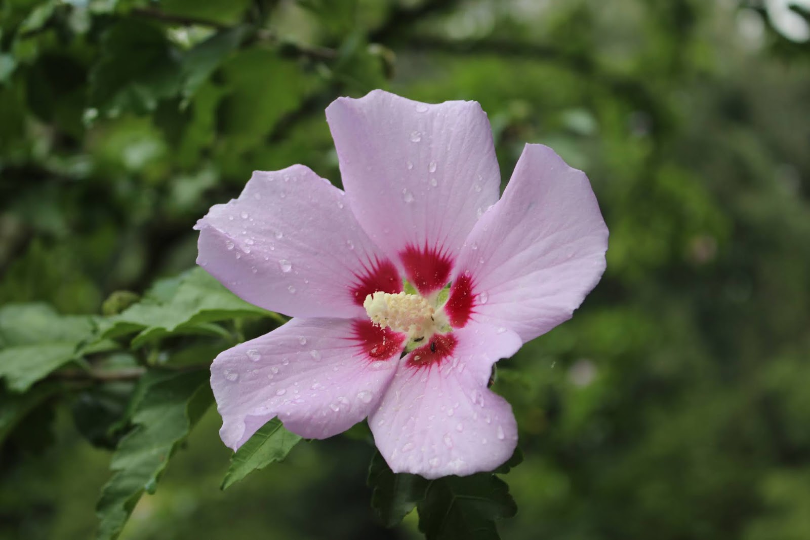
Rose of Sharon blooming at the Museum of Appalachia today. 
It is a very pretty and old timey flowering tree. 


Museum of Appalachia Visit  & Bluebird Fire Tower 

Sunday Aug. 23, 2020

Kenny & Dana Koogler

**Added to Country Store Blog Series as of Jan. 30, 2021**


   I've been going through a spell of really wanting to dig into history lately. 
I have also been going through a time of a strong aversion to crowds.   I decided on Sunday to scrap the original plan I had.  I wanted to go somewhere a little different that would not be completely ruined if the rain set in.    Kenny and I sat down in the living room and talked it over finally deciding to go visit the Museum of Appalachia and have lunch there.   We also got to looking at what else was in the area.   I found quite a few things, but we settled on wrapping our day up with a visit to Bluebird Lookout Tower nearby.   
IMG_3359.JPG
   above: Mr. Peacock was outside to greet us when we arrived

    Away we went toward my spiritual center... Clinton.  I every time I've ever gotten lost in Knoxville I wound up in or heading to Clinton.   It is like there is a magnet pulling me.  It is a running joke with us.   On the way to the museum the skies opened up and dumped rain on us in buckets full .   I had one small umbrella with me.   I decided if it continued we'd stop by Dollar General and buy another one and some $1 rain ponchos.    Thankfully just before we pulled in the rain let up.   I was able to avoid both the rain and the need to go on a DG run!
IMG_3363.JPG
Above:  Museum of Appalachia front door.  You purchase tickets here at the desk inside.  
  I had been to the Museum of Appalachia about ten years ago.  We were on a camping trip to the area. We camped at Norris Lake.  We hiked some of the lake trails.   We brought the four wheeler and went riding a little bit.  I don't recall much about that.  We also visited the Museum that weekend.   I liked it then, but since that time I have another nine years of being a Tennessean under my belt. I have since read Alex Stewart: Portrait of a Pioneer by John Rice Irwin at the urging of a friend, John Ungerer.   I have sense enough now to appreciate better what John Rice Irwin was trying to preserve.  I have a deeper appreciation for the pioneers and craftsmen like Alex Stewart.  John told me when he read the book that he got to the end and felt like his best friend just died.   I believed him, but a deep, touching emotional connection to someone through story telling is not a common thing today.  I found myself weeping when it got to the part in the book where he passed away.    IMG_3369.JPG
Above: front cover of the book on Alex Stewart.  $14.99 I call it a bargain!
    I went today to see the Alex Stewart cabin and the display on him. 
I will probably do a blog piece on him in the future.   Another reason was to look at the displays of medical items and doctors since I am going to be writing about Doctor Woman, May Wharton soon.  I wanted to see the Mark Twain cabin.  
I wanted to eat some good ole country cooking.   I have to say this experience was more fulfilling than my first visit.  It is like a living reference for historical things.   If I lived closer I would certainly get a membership and go frequently. I'd probably wear it out.  
IMG_3385.JPG
Above: Photo of John Rice Irwin.. the founder of the Museum of Appalachia. He is a cultural historian.  Below is a photo of Hank Williams Jr. with Will Meyer, John Rice Irwin's grandson.   Also included in the photo to the far left is Ring of Fire  song co-writer Merle Kilgore, (also by June Carter Cash). The lady to the right is the late Elizabeth Irwin and Senator Lamar Alexander.
IMG_3387.JPG

          I will only hit the highlights in this blog entry for there is too much material to include every bit of it.  I am still reading and digesting it.  Part of the visit as said was research for upcoming historical blogs.   I hope the trip pays off as fruitfully as I believe it will.   
Below: a view across the grounds at the museum.  It is a living history museum.
IMG_3396.JPG

     We arrived out front and were astonished looking at the grounds.  It was much bigger than we'd remembered.  I wondered if I'd even be able to see it all in a day?  Considering the targeted displays I planned on seeing.. It was possible I'd not have time to fit it all in, but we were in no hurry.   We visited first the gift store and then went outside.   We started our tour and I used the map they gave me to check out the Alex Stewart cabin next. You can't go in it, but I got photos.
Below is the Alex Stewart cabin shown with the sharpening wheel outside it. He raised at least eight children in that cabin!

Below is a photo display of Alex Stewart.  Telling about his mouth bow making and playing.
IMG_3453.JPG
Below: a placard telling about the various trades and gifts of Mr. Alex Stewart
IMG_3463.JPG
Below is a display case of the many and varied things he has made!
IMG_3458.JPG

    We moved on through the Appalachian Hall of Fame. That is the building shown below and the displays above are but a few.  It is an entire building crammed full of various displays on two floors!


IMG_3398.JPG


     Gwen's Little Playhouse 


  One of the cutest things I saw today was a tiny white building just outside the Appalachian Hall of Fame.   I am sure I saw it my first visit, but I did not recollect anything about it.    Today it just grabbed me as a sweet and very relatable piece of history.   The story goes that James Hubbard of Union County, Tennessee lost an arm when he was a youth.  He served as a tax assessor, deputy sheriff, truant officer, and school teacher.  He married and had one child.   He hired a local fellow named Will Elkins to build his daughter Gwen a play house.   TVA later took over the land for the building of a dam, but the play house which had been the envy of all her friends in the area ended up here where everyone could see it.   

IMG_3400.JPG
Above: outside of Gwen's playhouse
Below: a photo of Gwen as a child along with some of the furnishings of her playhouse.
IMG_3402.JPG

IMG_3403.JPG
Above: dollbaby and bed and little cane bottom stool in the playhouse.

Bower Fisher's Cat Sled 
  Another of the sweet little stories that got my attention was about Bower Fisher's Cat Sled!   Below is a photo of the little cat sled.   I like cats though ours drive me insane sometimes.   I have a kitten laying stretched out in the chair behind me as I type this blog article.  IMG_3423.JPG

       Marion Fisher lived up around Kyle's Ford not far from the Virginia line.   He had a couple kids come down sick with the diptheria.   One had died and the other, little Bower, was very ill now.   He told of having to go to work to provide for the family, but fearing he'd never see his daughter again.  He decided this day to walk or rather run, the four or five miles back home to eat the noon meal so he could see Bower. She was so seriously ill.
When Marion came into view of the house he was overjoyed to see his daughter, Bower was up and around. She had tied a string to a block of wood and was pulling it across the yard pretending it was a sled. He was so happy to see her recovered he took the rest of the day off and made her the little sled you see above.  Bower herself told that she had an old cat who learned to ride in that sled!  She said every time she came out to play that cat would run and jump in the sled to take a ride.   She and her family agreed to sell the pieces of what was left of it to John Rice Irwin for the museum.  The pieces were carefully collected and put back together.  
She wanted everyone to be able to see her little cat sled and know the story that went with it.   One of the things that made John Rice Irwin so special was his deep appreciation not just for the items on display, but the people and the stories that accompanied them.   That is what makes things truly special.  
   
Drinkin' Muddy Water, Sleepin' in a Hollow Log


   A very old blues song by Grant Jones says "I'd Rather Drink Muddy Water, and sleep in a hollow log."     It has been adapted by many blues artists since then from R.L. Burnside to the North Mississippi Allstars of today in their song "


Rollin' n Tumblin".    The massive trees of the eastern part of North America were the chestnut trees followed by the poplars.   The chestnut trees were killed off by the blight, but prior to that they were so large the pioneers often lived in them until they were able to construct more suitable dwellings.   Tim Homan is a great hiking guidebook writer.  He wrote one about Joyce Kilmer-Slickrock.
He mentions in this book that a naturalist, Oleta Nelms, who worked in the forest when he was there told him tales of the massive chestnut trees in the area when she was a child.  She said when she went to school she was teased because her grandfather lived in a hollow tree before he built his house!  Below is an image I found on the internet of a massive tree that would have been big enough to do this.  Image for post
                   
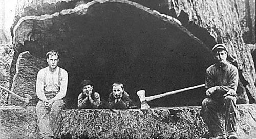
Below is a photo of a painting of the home of George Burkhart of Harlan, Kentucky.  He raised his family in a hollow tree!   He and his wife raised six kids in that tree! IMG_3476.JPG

   Banjo Picking 

  The museum has a massive display of musical instruments of various artists and their contributions to the musical world.  I grew up with a musical family.  My grandfather Clarence "Skeeter" Caricofe  was a singer and musician. He could play the banjo, fiddle, mandolin, harmonica, guitar, jaw harp. He had a real pretty voice that was so clear.    I play piano and flute.  Mom played guitar and piano and sang. Daddy played guitar and mandolin and sang.   I have spent many an evening at home listening and singing along to country, gospel, bluegrass and folk music. Every now and then there would be some thing contemporary thrown in.   Below is a photo of a banjo at the museum and the ground hog skin tacked up that was often used to make the heads for them!  Below that is a Youtube video of my grandfather playing and singing. It is one of two records he put out.

Below: ground hog hide for making banjo heads and a couple banjos.
  IMG_3442.JPG


Skeeter Caricofe Rosewood Casket


                           Blacksmith Shop 

  One of the things that appealed to me was the blacksmith shop.  
I had a great, great grandfather named Hector Croson who was a blacksmith from Steeles Tavern, Virginia.   I noticed my grandparents and many of the family had paintings of blacksmiths up in our homes.  I guess that is one reason why.. the family history.   He was a strong man and did well for himself.   My grandmother.. his wife.. was a Nancy Ship.  I don't know what her profession was, but I imagine it was keeping house and tending children among other things.   

   Below is a photo taken of the inside of the blacksmith shop at the museum.
I cannot help wondering if grandfather Hector's shop looked anything like this?   

IMG_3572.JPG


  I loved the old general store display.   I still recall stores like this growing up.  They were no doubt many of them "modernized" by the time I came along, but I remember some just the same.  How they smelled, looked, and what you could buy there.  Penny candy, cokes, and icecream were always a treat. 

IMG_3547.JPG

   Here is a story told me by my grandma Edna about her childhood and money and the store.
Edna, Vivian & The Feenamint Gum

   My grandma Lillian Edna Brooks Caricofe grew up one of eleven kids from a poor family.   She and her sister Vivian were walking one day and found a whole silver dollar!  They tried to think what to do with that great sum of money for two little girls.  They knew if they took it home to their mother she'd make them set a good bit of it aside.   They figured the best way to get the most for their money was to go straight to the store with it and spend it all on candy!
They went down to Seabird Mangus' store next to the train tracks and bought a lot of every kind of candy. .  They ended up with one nickle left over.  They couldn't show up at home with even a nickle or grandma would know they'd been up to something.   Vivian looked on a store shelf and said "Look here, Edna! We don't have any of this yet." It was feenamint gum.  They either were too small to read well or too excited to notice it said laxative on it.  They enjoyed their candy for awhile, but later that feenamint gum got to them and they got the belly ache.
She told me she reckoned that was their punishment for not taking the dollar home to their mother.   They took turns sitting in the outhouse and the other in what they callled the "Katy White". it was a spot in the woods that served as sort of second bathroom.    😉

Below: more items from the store
IMG_3549.JPG
Below: all those red and white ladles hanging up... I have one just like it in my kitchen now!
IMG_3550.JPG

     We saw Danl' Boone's cabin.  Mark Twain's Cabin.   (Samuel Clemens)
and a little log church.. Irwin's chapel. 

Below is the outside of the Mark Twain cabin

IMG_3574.JPG

 Here is a view of the inside
IMG_3582.JPG

Last, but not least.. a view of the grounds in a broader sense.
  IMG_3575.JPG


        I feel sure this will give rise to a great many historical blogs and will help flesh them out to be more interesting.     It was a great visit.

                     Bluebird Lookout Tower


Once we finished our Museum of Appalachia visit and had our lunch in their restaurant we headed off to the next adventure of the day.   We realized this morning that only a few miles away on a knob overlooking Clinton was a lookout tower we had yet to visit.    We set off through the countryside toward it.  I told Kenny I believed there was an easier way to get to it than to double back to Racoon Valley Road and come at it.  We went instead up to the main area just off the interstate and took a look. The road right beside us, Buffalo Road, was a good starting point.   

    We drove out through some pretty countryside.  Lots of Summer wildflowers bloomed in the fields along the way.   I saw lots of pretty pink Joe Pye weed, leaf cup, New York Ironweed, and Virgin's bower.  We climbed up and enjoyed the pretty view for awhile.   Finally we climbed down and headed back off the mountain.  I felt very fortunate to be married to a guy with the right connections to get me to some of the places I like to go!  It tickled me to feel like we'd gotten away with something.  

Below is a patch of Joe Pye weed with its tall pink wands.  
 Below: I'm not sure, but I think this is Hinds Creek. It is an old muddy cow creek.  That is what we swam in a lot when we were little. 


    We followed the route out through the country. Kenny began to have that feeling he'd been to this spot before.  I knew I had not.   We pulled back into a long lane that on google maps said "Firetower Road" like so many other roads like it in the state.   We passed a few old barns, sheds and a couple houses.   We arrived at a locked gate.  We had discussed before ever leaving home that the road might be gated.  Lo and behold, it was.   I figured that was the end of the trip for the day.  Kenny got out and said "Let me see if any of my access codes or combinations work on this lock."  He fiddled with it a bit, and turned around grinning at me.  It had worked!   He opened the gate and we drove through.  I got out and latched it back.  We dummy locked it so as not to attract unwanted attention.  We drove right up to the top.  He took one look at the towers up there and the electrical equipment. He began spouting off to me when and what he'd done here before, and how tough a place it was to set up.  He then said "I must not have known there was a fire tower up here?! Leastways I did not come up to look at it."  

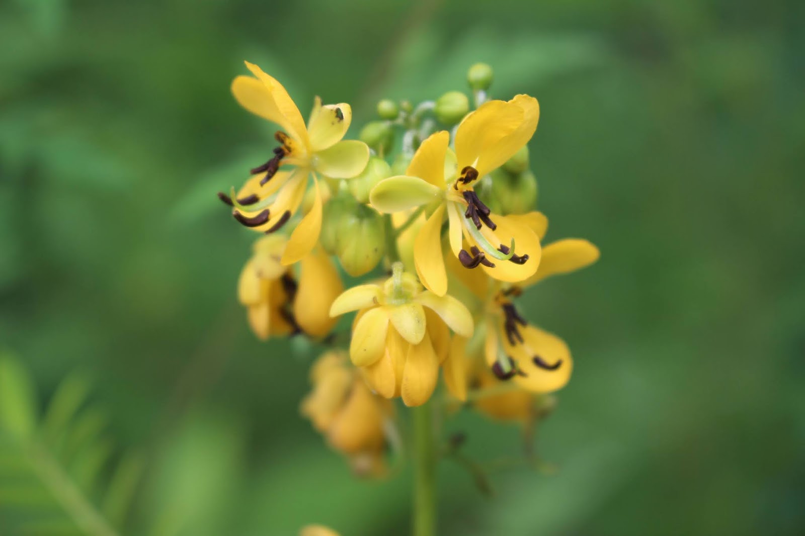
      It was not anything earth shattering or different, but it was a nice tower in a kind of pretty spot.  The view even from the open area on the ground was beautiful.  The fire tower was like many others except it was in good repair.   The cab was locked, but the steps and platforms were in perfect shape.   We climbed it and took a look around.  Far off in the distance you could see glimpses of Clinton and the Clinch River.   The sky was azure blue compared to the gray rainy skies of this morning.  It was clear and sunny now.    The clearing had some pretty flowers at its edges.  Red velvet peaks of staghorn sumac and bright yellow clumps of wild senna. All in all it had been a great day.   I anticipate many more blogs as spin offs from this one visit to the museum. 
 Above: wild senna looks like tiny vicious creatures with fangs!
 Above: bright red staghorn sumac berries
 Above: some of the outbuildings up on top the mountain near the tower.
 Above: climbing the steps over and over to reach the top.  At least they weren't rickety!
 Above and below: Bluebird Lookout Tower keeps watch over Anderson county.
 Below:  A grandstand view out across Tennessee! 
 Below: a couple photos of Virgins bower. It is very sweet smelling in the evenings like night blooming jasmine. It is a wild vine. 

Thursday, July 16, 2020

Scouting Trip 2/3 Devils Triangle


Asiatic Dayflower is a tiny blue wonder in Summer 


Scouting Trip-- 2/3 Devils Triangle

Sunday July 12, 2020
Kenny & Dana Koogler 


Pictures are here: Devils Triangle


   Going through some old photos recently I came across two photos taken the time we rode the motorcycle around Devils Triangle.   Motorcycle rides are not conducive to photography.  I got the maps out and began looking at the triangle.  I phone Kenny up while he was still at work.
"Here's something for you to ponder.  Remember when we went around Devils Triangle?  You want to go do it again with a different vehicle?"  
He said he'd think about it, but I knew the answer already.  Sure enough he was more than happy to make a repeat trip.  

Above: One photo taken while riding round the Devil's Triangle several years back on the motorcycle.   Beautiful fields of purple New York Ironweed and golden wingstem in bloom on a rainy, misty day.  

Below is the one other photo taken at the same spot of Kenny on the bike


Kenny has stopped to let me take a photo of something particularly pretty.

    Scouting Trip 


 I am a creature of reason, but I am also led by instincts.  
I had the sense  we needed to repeat this trip.  I did a lot of online research of the area around the scenic, exciting drive called Devil's Triangle.
It is around Fork Mountain.  It is made up of Hwy 62,  SR 116, and SR 330.
It is a curvy mountain drive that is heavy on excitement, scenery, and history thick enough to cut it with a knife.  

     Below is the logo that shows the route of the Devils Triangle. I do not own the photo, but am just displaying it for demonstration purposes. 
   

   We started the loop clockwise because it is more exciting and the good stuff is mostly on those two pieces of it.   Rt 330.. Frost Bottom Road is to me.. a cool down after the first two thirds of it.   It is easy driving, but it is mainly just a pretty country  drive through a residential area.  The only real place to get off the road along it would be to turn aside and make a trip on Hoskins Gap Road to Windrock Campground.      We left off the final 1/3 of the trip.... the last nine miles out Frost Bottom Road... Rt. 330.  We were hungry and took a speedier exit route to get to a very late lunch.  

     
Trip Highlights & Findings


    The area around Petros and Devonia is full of natural beauty.  It is charged with history.  Once this area was a thriving community with many churches and homes.   The coal industry was a booming business out here.  The roads you drive on in coal country are often patched heavily. You look closely and you'll see many shored up areas where the road has crumbled off the mountainside.  Coal seams make for unstable ground.  We found evidence of former coal operations, lots of area churches,  and cemeteries.
Fork Mtn Baptist church red bridge.jpg
Above: Fork Mountain Baptist church with its colorful red bridge
      The area is suffering from a lack of rain somewhat like much of Tennessee is this Summer.  The New River was very low.   Since we were in the jeep we did not have the ability to explore some of the areas I wanted to.  I think I see a drainage with potential for waterfalls, but it will have to wait for a time when we have had some rain.  A friend came home and posted photos of Atlas falls that is a wet rock. 
Below: the New River right at the bridge.  Very low water.
IMG_1925.JPG


   Below: a better look at Fork Mountain Baptist church
IMG_1927.JPG
   
     IMG_1934.JPG

   Above: Outhouse behind Fork Mtn Baptist church.


  A bit further down the road we turned into a lane that was a trail.   We only went far enough to see where it went and to see the river.
Below:  the ford of the river where we drove through
IMG_1947.JPG
     
 I walked downstream exploring and found holes of much deeper water.
IMG_1943.JPG
Above: green waters of the New River
We did not see a lot of Summer wildflowers, but some. Below is a nice patch of purple phlox.
IMG_1948.JPG

I did see a real pretty Queen Anne's lace bloom that was tipped with pink.

IMG_1951.JPG

I  found an old bridge abutment I'd been looking for, but the google image was out of date. All that remains is the concrete piers.  The metal frame is now gone.
IMG_1958.JPG

 We continued down the road and stopped at the old coal washing plant.
It is a hulking abandoned complex of chutes and buildings and little ponds filled with tailings from old mines and coal works.

    I wanted to finally see the old abandoned train. I'd seen lots of photos of it. I knew it was supposed to be somewhere behind the coal washing plant.  We pulled in and found it easily.

IMG_1960.JPG
Above and below: coal washing plant. It has been closed since the 1990s.

IMG_1962.JPG


  We had to drive across a bridge behind the coal plant to reach the siding where the train sits.   The view of the New River from here was really something.

Mimosas from the bridge bv.jpg
Above: mimosa blooms scent the air and frame the New River

IMG_1974.JPG
above: the former New River scenic railway train. It was an excursion train.  They brought it here from Arizona in 2005.  It consists of an engine and two passenger cars.   It ran for awhile then sat abandoned sometime around 2010. It has been vandalized. The windows smashed out.   There has been talk of rehabbing this train and the tracks and getting the excursion trains running again.    Other possibilities that have been discussed for the old tracks which have now been officially declared abandoned include a rails to trails conversion.  Virginia and Pennsylvania and a few other areas have had real good luck converting former railways into hiking and biking trails.  Either one of these options sounds good to me.  I will say that I can't help thinking rails to trails would be less costly than fixing up the train and the tracks again. 
IMG_1977.JPG
     We visited with several other folks who were there at the train checking it out.
One older couple was from the area. Fascinating to talk to.   He told me the train had set there since the 1970s.  In checking that is inaccurate. I think where he got the 1970s time frame was from the fact the rail line was bought by National Coal Company in 1973.
Below: inside the coach car of the train
     
IMG_1981.JPG

Below: inside first class passenger car

IMG_1983.JPG

On the way out of this spot I noticed a Kwanso double lily in the ditch.  I have lots of them now, but I still think they are pretty and a good find.
IMG_1988.JPG
Heirloom "ditch lilies" Kwanso double.

   After the train Kenny drove us up one of the old haul roads.  He was curious as to where it went.  It did not go anywhere except up to the flat topped mountain that was obviously put back together after strip mining.   At least they cleaned it up.   I thought I heard water running real hard ,and got out of the jeep. I walked over and peered into the weeds.  I had to move poison ivy branches and thorn bushes out of my way to see.   The tailings pond way up high on the mountain was leaching water out hard enough to form a small cascade near the road. It then flowed under the road in a culvert to additional catch ponds below this point.
 Below is the source of the water I heard gushing.  If you notice the rebar sticking up in a row... it kind of sets the tone for the area. ROUGH!
IMG_1990.JPG

  Another area I wanted to check out and photograph was the old Rosedale Elementary school.  I was perusing the map prior to us going out there. I had it in satellite view.  The map indicated Rosedale Elementary (Temporarily closed)
With Covid19 going on... I was not sure what was going on.  I figured maybe it was just temporarily shut down like all the area schools have been.  Zooming in closer I could tell it looked to be in rough shape for one that had been in use til  March 2020.    I did some checking round and found a newspaper article that told how two area men were renovating the old school. They planned to turn it into a museum.   The article was dated 2009.   I wondered what we'd find?

    We were pleasantly surprised to find the old school has indeed been fixed up.
It looks amazing.   The status of the scenic railway is still sketchy. The men who fixed it up planned on using it as a depot for the rail line.   It appears now it is going to cater to the ATV crowd as lodgings.  I plan to call Jimmy Byrge and have a conversation with him to find out what the status is on all of it.

IMG_1991.JPG
Above and below: parts of the Rosedale school have been fixed up and look good!
IMG_1992.JPG

Orange butterfly weed was blooming by the road at the school.
IMG_1998.JPG


    We then stopped by the New River General store.  I had long seen other folks photos of it. I wanted to see it for myself.  It was closed on a Sunday, but at least we got to see it.

IMG_1999.JPG
Above and below: views of the Blue & White Station.
IMG_2000.JPG
Below: a view of New River Highway 116.  A back road that takes you into the past.
IMG_2003.JPG

below is the W.L. Coker store. It is open except that today is Sunday.
IMG_2005.JPG

   Next we came to another spot I wanted to investigate.   I had told Kenny there was a new campground that had both RV spots and cabins for rent.  He tried to look it up and told me I was wrong.  He claimed the only new campgrounds were around on the Wind Rock side.   Ligias Fork has cabins to rent and six RV sites with full hookups!  It is by the river and is very attractive.    I later learned that the same fellow,Jimmy Byrge is the business man who runs this outfit as well as the Rosedale school.
IMG_2007.JPG
Above: Ligias Fork cabins and campground
  IMG_2010.JPG
Above: suspension bridge over Ligias Fork.. not New River, but a tributary.

Below: the RV sites with full hook ups.
IMG_2014.JPG

below:  one of the cabins. I believe there are three total. Very nice!

IMG_2016.JPG
Below:  Contact info for the campground and cabins.
IMG_2018.JPG

In reviewing the website and their Facebook page.. the Rosedale school is lodgings also for rent.  Calling it the Rosedale Retreat.

   On down the road we came to a turn that looked interesting so we took it.  It was Patterson Road.   It went to a ford of a stream and was supposed to dead end at a cemetery.    It wasn't too interesting, but we did find another suspension bridge!
IMG_2027.JPG
Above: suspension bridge and below.. the stream under it.
IMG_2034.JPG

  I saw wine berries beside the road and had to stop and pick us some. We have these on our farm in Virginia.   They are delicious.   I got a couple handsful of them.
IMG_2036.JPG
Above: ripe wine berries

    We continued round Hwy 116 on roads that gave us a partial view through the tree canopy.   Long way down!  The roads through here are super curvy

IMG_2038.JPG
Above: Al's Market... also closed on Sunday.


   We moved on to a spot I had not anticipated next.  The Circle Cemetery.
I knew before coming out there that 1. the Coal Creek Wars happened over coal miners vs. the state using convict labor in the mines.  2. that a mining disaster out in this area claimed a lot of lives.   I was only partially informed.
The area employed a lot of Welsh and foreign miners, but primarily Welsh because that is what they were great at in Wales.   Briceville Church was constructed by Welsh miners who moved to the area.  The culture was influenced by them heavily.   Circle Cemetery is another example.

   Below: Briceville church is in the national register of historic places. It looks like American Gothic, doesn't it?  Like something that should be in a horror movie.  It is a pretty and cleverly constructed church.  Built by the Welsh miners of the area.  I'd love to know why they decided on this design.  You can walk to it, but not drive.  IMG_2058.JPG
Below is a view of the cemetery behind the Briceville church.
IMG_2059.JPG
Below: beside the Briceville church runs a set of long abandoned rails.
IMG_2056.JPG

Below: this is the view of the church from the spot you have to park.  It definitely caught my eye.  I was going to see it. No doubt about it.
IMG_2055.JPG

Below are two historic markers that sit at the parking spot to walk up to the church.
IMG_2054.JPG

IMG_2053.JPG

   so from these two markers I figured out there were TWO mining disasters in the area.  Crossville Mountain Disaster happened December 9, 1911 and out of 89 miners 84 perished and five were outside the mine and survived.  It says they were rescued, but per a local historian the reason they did not die was that they had not yet entered the mine.

   Fraterville Mine Disaster happened May 16, 1902.  Two hundred sixteen men in the mine and all perished.  At lease four families in town lost every single male member in that mine explosion.  Only three male members of the entire town survived.  It is to this day the worst mining disaster in the South.

      Now back to the Circle Cemetery...........
IMG_2041.JPG
The miners buried here from the disaster have their graves arranged in a circle.
Possibly because of the Welsh influence on the town. Miners depend on one another like soldiers in battle.   They had a brotherhood like the military.  They viewed themselves as equals in life and work... and equal in death.   They are buried together in a circle both here in the Circle Cemetery and the Leach Cemetery in Rocky Top (Lake City) nearby.    The stone circles found in Wales are fascinating, but the purpose for their existence is unknown.  Many speculative theories have been put forth the most popular being for astrological purposes of planting and harvesting. Another is for religious rites.

      below: photo of the central burial monument at this site.. looks like one of the tools made of stone has broken off. IMG_2042.JPG


Below is a photo of the entire monument it is the center of the circle
IMG_2043.JPG

Below is a photo of as close as I could capture of the circle shape of the burial.
It is large and on a hillside so I found it impossible to illustrate by photo.  You can see it by being there in person, but even then it is a little hard to picture on that hillside.

  I found a photo on the internet of the Leach Cemetery circle burial of miners. I am placing it below because it was taken from the air.  It shows far better how this is arranged.   It is not my image, but I am using it as an illustrator.
View of the Miners Circle at Leach Cemetery in Lake City, Anderson ...
Below are photos of four individual graves at the Circle Cemetery.  It was very sobering to read the same date of death on one after another in that cemetery.
Emmett Miller
IMG_2049.JPG
S.H. Miller
IMG_2050.JPG
Henry Burton
IMG_2052.JPG
J.T. Carden
IMG_2048.JPG

   So I learned a lot about this area and now I have a little validation regarding the sorrow I feel in an area such as this.   Beauty and sorrow in the same place.  

   We moved on to look for another historic site I learned of two ways. 
I saw what appeared to be an abandoned rail bridge from a satellite view of the area.  I later learned more about it and figured out it was the same bridge.. on bridgehunter.  The Slatten Creek Bridge or Drummond Bridge.   It was the site of a hanging and is supposed to be haunted.  One of the newspapers even ran a story about it awhile back, but I did not read it until I learned of the bridge's existence.

  It is located behind the Briceville post office. The north end on the post office side... is so overgrown with kudzu it is impossible to see in Summer.
IMG_2060.JPG
Above: a photo of the post office on the right.. the pile of kudzu across the road... is where the bridge sits. From this side you can't tell its there.
Below: an image taken from the south side... you can see it far better, but it is in a residential area.   
IMG_2061.JPG

  The story is that a local miner Richard Drummond got into a brawl with a soldier from the National Guard and Drummond killed the soldier.   He was hanged from the bridge for his crime.   They say his ghost haunts the bridge. 
I later spoke to an area historian who told me something rather confusing.  
It was the worst non sequitur I've run into in awhile.   He told Kenny and I that the story about it being racially motivated was false. That the only reason he was hung was because he was stealing. Not because he was fooling with a white woman.   blink blink..... okay.  I'll just say the stories about the hanging are many and varied leaving the facts unclear.

           We moved on from the bridge to our last spot we'd hunt for today.
I learned of the existence of an abandoned airforce base at the top of Cross Mountain nearby.   I wanted to see it.   We headed in the general direction using the TomTom.    She began saying "Turn around when possible."  About the time we wondered if we could trust the directions... two men pulled up in a side by side. I flagged them down to ask them.   I introduced myself and asked if they could show us how to get to the abandoned airbase. The older fellow grinned and told me yes, but that it was part of Wind Rock's trail system. We'd need a permit to visit.   I was very glad we had not tried to go any further without knowing. I don't want to upset anybody or go about this the wrong way.

       We got out to visit with these fellows.  It was a really fortunate meeting.
I felt blessed!  Bennie Aslinger is the fellow wearing a Wind Rock security uniform.   Dwight Isabell was his buddy riding along.   Both of them as nice as they could be!  We were treated to a very interesting historic discussion and mini tour.   Bennie is a wealth of knowledge and has actually lived much of it and experienced the things I read about over my morning coffee today! I read about the base and there being no road access. The men who worked there had to ride an aerial tramway up from the base of the mountain.   We were actually at the site of the lower part of the airbase!  This is where they boarded the tram to go up.     
IMG_2063.JPG
       Above: Mr. Bennie Aslinger of Wind Rock security force.   He is amazing in his knowledge of history.  He has the same dry, dark sense of humor I do. 

 We got a mini tour, lots of great information for a future trip, and made two friends into the bargain. I'd say we won the Lotto today!   We found enough out here today to warrant at least a weekend trip to spend out here and explore.
All this did was whet our appetite for more!   

Below is a photo of Kenny leaning on the jeep door and chatting with the two fellows.  
  IMG_2064.JPG

The blue building pictured behind the jeep is what housed the tram.  It left from there to go up the mountain and back down.  An article I read said it was set up on a pulley system like one of those devices where you have a clothes line on a pulley system between two buildings.  You can hang your washing out from one spot by pulling the line.    See the image below. Now imagine that is what is going to convey you up the mountain and back down. Yikes!  Amish clothesline pulley system | Clothes line, Pulley, Amish clothing

IMG_2065.JPG
Smoke stack at the former air base
Another original building or two shown below. 

IMG_2066.JPG
Below: Bennie points out to Kenny and myself where the tramway went up the mountain. The area of lighter green within the red circle is what he pointed out as being the path it took. It was dismantled and removed, but that is the scar from where it was.

    He described for us and pointed out the guard shack at a check point at the base of the mountain.  There was a machine gun nest there to shoot bad guys if they showed up trying to approach the base.   The need for this was back in the Cold War era and had to do with protecting Oak Ridge.  This was the home of the 663rd Aircraft Control and Warning Squadron constructed in 1951.  I did later read that while the tram way was the conveyance to the top part of the base, there WAS a road existing to the top, but it wasn't fit to use.  It was so full of potholes and so treacherous it was a joke.
Bennie described riding it and how it dipped and swayed.  It had steel towers helping support it every so many feet up the mountain.   He pointed out a low ridge and said that as the "bucket" dipped down over that ridge it was really something.  They called it the 'gravy bowl".   It took them 30 minutes up and 30 minutes back down on a good day when the weather was fair and the lines not iced up.  The compliment on the base.. at the top and bottom was 227 airmen, 14 officers, and 26 civilians.   116 families were represented from the area.   They lived mostly in Lake City and Clinton with a few living in Norris and Campbell County.     The base helped the economy of the area a great deal providing commerce and many jobs.  I had no idea there was ever a country club in little ole LaFollette Tennessee, but there sure was!   

    Later the budget cuts in the 1960s closed the base.    It now stands abandoned.  There are a couple radio towers and one tv station tower at the top of the mountain.   Apparently the design and positioning of the air base and radar station was not good from the start.
It was too high to pick up low flying aircraft but the lower portion was in a bad spot to detect also getting too much clutter from surrounding hills.    

     We finally parted company with Bennie and Dwight and headed out.  We were famished. 
It was 2 pm and we had yet to eat lunch.   We finally decided to push on toward Oak Ridge. We held out for Freddy's for lunch.  Our favorite place.  A perfect place to eat lunch or get a treat.   Freddy's is about as all American as you can get.  He was a patriot, a soldier, and a veteran.   Our kind of guy.     If you haven't tried it you should!  I will not eat hamburgers in a restaurant setting.   I will however eat a Freddy's steakburger.   They are sinfully good.
Steakburgers with mustard, onion, and pickles.   Best fries in the world.  
I never have room enough left over for frozen custard. I'll fix that.  I'll have to go sometime for JUST dessert.   It will be worth a special trip.    We don't have one yet in Maryville, but I wish we did.  I know of one in Morristown and one in Oak Ridge. 
IMG_2070.JPG


     I see in my Crystal Ball of the Future....
A trip to the top of Cross Mountain to visit the rest of the airbase the proper way.
I see more exploring the Devonia area and a return by a prodigal... me.... to Wind Rock.
I agree with Bennie that the Briceville/Devonia area is the pretty side of Wind Rock.
The other side is too crowded and too groomed for me.  I like the wild side.

   I need to put aside my dislike of the Brushy Mountain prison and talk myself into a tour as well.   It is a creepy place, but I will get my head right and go.  I might end up liking it.