Showing posts with label Graham County. Show all posts

Wednesday, February 8, 2017

Murphy NC Weekend Get Away--Hiking and Exploring Waterfalls

Murphy NC Weekend Get Away--Hiking and Exploring Waterfalls 


Dana & Kenny Koogler

Sat. Feb. 4 and Sun. Feb. 5, 2017


**Edited to Note-- as of 3/18/2024 I went back to add this blog entry to the Valley So Wild series. 
I updated it with a few bits of info now known to me.  I am adding here a historical account of the history of Burgan Creek Falls and the area immediately surrounding it written by Mr. Marshall McClung.  I believed (wrongly) that I had already added this account to the trip reports about the falls, but realized I had not.   It is valuable historical info that is in perfect keeping with the spirit of Valley So Wild and the blog series. Preserving the history of the Little Tennessee River watershed.  

   
    I am way behind on blogging and hiking for that matter.  I've got two previous trip reports still unwritten.  We are helping raise a grandson at the moment. It has turned out to be a blessing, but a challenge.  At 52 years old I thought I was done having and raising babies.  I have not quit hiking or blogging, but when you've got someone waking you up at 3 am hollering "Bah-bah bah bah bah!" (Gabe's word for bottle) your priorities change.  

         I took Gabriel over to his other grandparents home on Friday afternoon.   I used Friday to decompress a little.  Saturday morning we left early and went prepared to either stay in Murphy or drive home... whichever we preferred.  We spent Saturday just hiking and enjoying Fires Creek WMA.  It was a perfect day for hiking. Sunny and warmed up to fifty degrees by midday.
We found Bald Spring Falls without any real trouble. Kevin Adam's directions were very good.
It helped being somewhat familiar with the area, and having a map.   We sat at the falls and ate lunch.
The waterfall is actually three falls on the same stream. We only went to the first one.   We did not
try to bushwhack to the other two.  We will do that another time.  There was enough water coming over to make it pretty, but not enough to have made Bald Spring Falls.. the furthest one up... really pretty.   The stream was nice and clear.  A few patches of ice and ice bats hung from limbs in the creek.   I have found that my frustration level has been so high at home that I cannot tolerate much
when things go wrong.  It has been so bad that while I want to get out and hike I prefer sticking to sure bets instead of gambling.  My nerves just won't handle any more right now.

 Lower Bald Spring Falls  Here is a link to the video of it.  Bald Springs Falls video
Icicles under a log in the stream.

   
    We went on out one of the gravel roads in Fires Creek and found a long, sliding type falls we had seen last Spring.  We did not go down to the base of it then, but today we came prepared with a long rope.  We tied it off and used it to go down the steep slope to get to the base.  We were able to get some fair shots of it.  We named it Long Branch Slide since it was on Long Branch and was like a slide. Very original and well considered, eh?  :-)   Taking photos of it from the base eliminates the view of the upper parts of the slide in the photo.  It is about 60 feet long or better.  Plenty of water coming over it today.  

Long Branch Slide Long Branch Slide video on You Tube

I set these videos to gospel songs of praise and worship.  Don't watch them if you are offended by God and Jesus.  I am leaning hard on the Lord during a tough time.  Psalm 61

           We left with the sun dipping low on the horizon.   We were tired and happy and hungry.
We found a motel room in Murphy and opted to spend the night. We tried out Brothers Restaurant.
It was very good and they have several locations. Lots of good reviews. We were not in the mood to get real dressed up tonight for dinner.  Country casual was just right.   We did a little bit of shopping in Murphy before we turned in for the night.   Kenny had me laughing at dinner until I thought I'd pee my pants.  It was a fun evening.  Much needed night away from home and the routine.
We both slept well. I remember waking at 5 am to go pee. I felt good and thought I was done sleeping for the night.  I woke up two and a half hours later!  It did not take long to pack and check out.  We grabbed a quick bite of breakfast and headed out to do some more hiking and exploring.

      We headed toward Andrews to try to find Cover Falls.  A friend had given me great directions.. PERFECT directions! We also had a way point in decimal. I was thrilled that I converted it just right. I had not converted a way point in so many months.  Cover Falls lies on private property, but sits below a forest service road that provides a chance to drop down to see it without tromping through the homeowners property.   It is worth the stop.
Cover Falls is a little over 30 feet high.  It is quite pretty.  There is some sort of little grotto up above it to the left (facing the falls).  There is also an old water pipe going past it!  If you trek on by the falls a bit further there is a valve sticking up out of the pipe in the middle of the trail. It was leaking.
Britton Creek is the stream it is on. You drive Tatham Gap Road to approach it.  Tatham Gap Road is part of the Trail of Tears.  A sad thing to remember, but an important part of history to recall lest we forget and repeat it.    We have driven the other side of Tatham Gap Road when we went to Teyahalee Bald fire tower.      We did not drive it through today out of concern we'd find it gated way out near the bald, then have to turn around.   We went on toward Robbinsville to head home.

Here is a link to Cover Falls video

       We stopped in Robbinsville at Ingles to buy a few groceries before heading home. I did not want to get home and have to go back out again.  We put the cold stuff in the cooler until we were home.    The weather wascold and drizzly this morning, but warmed up and turned sunny. I  We decided to try to find Burgan Creek Falls from Atoah Road.   We had made a futile attempt from Long Creek Road  several years ago.  Kevin Adam's description of it being confusing was dead on.   His directions are perfect , and you get a good start, but then  all evidence of a trail disappears leaving you to guess your best.  Casey Marcum  bravely found it from that direction. He warned me to try it from the west. On his bushwhack he spied a trail coming in from the opposite end!  I had already figured bushwhacking in from Atoah Gap would be shorter if not easier.   We were blessed in that someone has created an actual trail from the road all the way to the falls. It is flagged the entire way.   It is easy to follow.  Whomever did it..... Thank you!  **Edited to Add -- Trail created by retired foresters Marshall McClung  & Hoot Gibbs! 

Here is a link to the directions page. Burgan Creek Falls Directions 
It is an extremely pretty waterfall.  We were very pleased to find it .   We were tired, happy and ready to head home. I napped in the car all the way so I did not have to deal with the Tail of the Dragon.  We were both grateful and recharged to face life again.


 Two views of Burgan Creek Falls.  It was exquisite in my opinion.

     
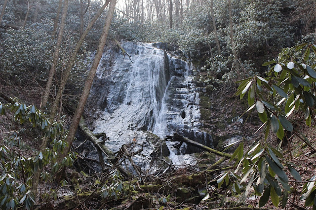
Here is a video of it below. It is about 60 feet tall.  

Tuesday, January 20, 2015

Squally Creek Scouting for Waterfalls

Squally Creek Exploring

Dana & Kenny Koogler

Thursday January 1, 2015

Photos are here Squally Creek


   We really like the Robbinsville, North Carolina area and Graham County.   
A relative shared with us a tip about a spot he'd been recently with friends.  Back around Halloween.
We'd been keen to go since then, but did not get the chance until after the Holidays.    We started our 
New Year off in 2015 by hitting the trail and exploring.    

     We went up to West Buffalo and  hoped to see some pretty things along Squally Creek.
We were not disappointed as the stream is a series of beautiful cascades, small falls and slides.  
It is wild and green. It also has that gritty element that we have developed a taste for.


Squally Creek stretching on before us.  Looks like some in the Smokies without all the people.
Pretty cascade along Squally Creek

Another small falls along Squally Creek a little further up.
I think there are more falls, but need to go back and be prepared for some creek walking.

     We passed old abandoned trout farms, private residences, Unabomber type shacks, disused hunting cabins, and all sorts of sign of human habitation along the way.   It always makes me very nervous when I see the faded stars and bars flag flying over a shack.   Gulp!  It was cold and the deep shade here in this holler had snow lying about on rocks in the stream. Icicles hung in some spots.   


Snowy ford of Squally Creek . This little area on Earth is so lovely.

   We proceeded up into the headwaters and the terrain leveled a little bit.    It lies below Hooper Bald. 
We keep ambling around and before we knew it we came out to this frame for a shelter..


This is at King Meadows. After studying the map we think it might be possible to follow the drainage down
from King Meadows to Upper Falls on Snowbird Creek.  It would bring you out right at it, but it remains
to be seen whether I do that or not.   

     We ambled around in the mountains and found according to the GPS we were closing a loop.
We passed some hunting or fishing camps on South Fork Squally Creek.   It was so isolated an area it was hard to believe we came upon anyone! 


South Fork Squally Cascades, sunshine, snow!


We made it back to where we parked and this is what Squally Creek is like down at that elevation.
How do you like that coolin' board? 

We had a good time and will go back again. 

Wednesday, September 3, 2014

Snowbird Wilderness Hike to Sassafras Falls & Big Falls

Spotted Jewelweed near the start of the hike.


Snowbird Wilderness Day Hike--Sassafras Falls & Big Falls

Dana & Kenny Koogler

Round trip miles 9.59

Labor Day Monday Sept. 1, 2014


Pictures are here: Snowbird Wilderness Pix 


   What makes me decide to hike in a certain area?  I am not sure.  It is a fanciful thing.
 We have no shortage of beautiful places in our area to hike.  I had been hearing the call of my muse
and feeling a pull in the direction of the Snowbird Mountains of North Carolina.   I had hiked in this area
many times before. I had done this particular hike once about eight or ten years ago.  I kept feeling
lead to go again.   Kenny agreed to go with me on Monday and so we did.

     The first time we hiked here was with a friend. We day hiked it then as well.  The plan was to hike
to Sassafras Falls, Middle Falls and both drops of Big Falls in a loop.   We were going to skip Upper Falls today for several reasons.  I had been told Upper Falls was not that great and was a real bitch to get to.
The water levels were low which would have made the toil of getting there more disappointing at finding
the flow poor on the falls.   The month was October or November.  The days were growing shorter and we knew we'd be coming out in the dark even skipping the Upper Falls.

      Snowbird is not an official wilderness, but a proposed wilderness. I will refer to it as the Snowbird
Wilderness just for the sake of simplicity.  Regardless of the designation and official status it IS wilderness.
The area is located in the Snowbird Mountains of far western North Carolina.   It is largely roadless and
sparsely populated when compared to many other areas of the state. It is far less visited than the Great Smoky Mountains National Park.   The area was logged in the past and the trails are constructed on old
narrow gauge rail lines.  We were able to see the cross ties in many spots along the hike as it
parallels Big Snowbird Creek.

     The wilderness is located at the outskirts of Robbinsville, North Carolina in Graham County.
I always read up on an area in anticipation of a hike.   I learned some very unexpected things about the
place.  Graham County is home to the Snowbird Indians. I wondered what on earth that meant?
They are Eastern Band Cherokee. Instead of having a large reservation in one massive plot of land they have lands scattered in parcels throughout the area.  Instead of a big push for tourism as you find on the Qualla Boundary in Cherokee, NC they are more traditional.  It is a quieter existence.  I have read there are more
full blood Cherokee in this area than anywhere else.  I liked what I learned and I hope their culture
and people continues to thrive and prosper.

       We had trouble even finding the trail head the first time we were here.  Today we went right to it
without a hitch.   The road was in good shape. Campsites line the road.  The forest was deep green and beautiful.  The drive was pretty the entire way especially once we crossed into Graham County.
They take care of their roads, but they do not cut back the Summer 'weeds" the way other areas do.
I benefited from this today because the roadsides were lined with the most gorgeous late Summer wildflowers.    Along the Cheoah River on the way in were great swaths of sunflowers in bold yellow, pastel pink Joe Pye weed leaned out toward the road waving in the breeze.   Further on on the fields contained
sochan.. the greenheaded coneflower in great numbers.  Tall, tall purple spires of New York Ironweed
sparkled in the sunlight.   Spotted jewelweed was innumerable little orange gems along the slopes.
Tall blue lobelia and red cardinal flower spiked up along the road. White asters, snakeroot, and Florida blue lettuce grew as well.   It was a sight for sore eyes!


   We arrived at the trail head to find that instead of having the place to ourselves as we thought we might.. there were eight cars at the parking area.   We were a little disappointed having both grown fond of our ability to select obscure places.  No worries. We gathered our gear and prepared to hike.  I noticed Kenny had taken my rain coat out of my pack.  I asked him "Did you bring your rain gear?" "No," he replied "Its not supposed to rain today."  He knows if I have my rain gear and he does not that I will leave mind behind and just get wet with him.  I had packed dry clothes and shoes in the car so I was ok with whatever.
The day was growing warm.  We had clear blue skies at the moment, but these mountains make their own
weather.  They always do.

       We found the trail in good condition.  It has been maintained to a higher than usual standard.
I have it on good authority that the SAWS group was to thank for that bit of good fortune!  Thank y'all
for all your hard work.   We passed a turn off on the way that I did not recall. A trail takes off to the left
only about 0.3 miles from the start.  I later looked it up and saw that it is Trail # 415 Snowbird Mountain Trail.  I have never spoken to or read a report from anyone who has ever traveled that.  It was well marked, but did not appear to be well traveled.   We continued on with Big Snowbird Creek below us to our right.
We were hiking upstream. The forest was deep green and again I was smelling and tasting colors. Today I
smelled and tasted green.. but I learned that "green" here in this area has a different smell and taste than other places!  I smelled and tasted "gold" and "silver" today along with pink again.    Synesthesia certainly makes life interesting. The woods were quiet and pretty.   We soon passed a group of eight backpackers on their way out.    I guessed most of the cars we saw belonged to them.  Later I would learn I was correct.

       Tall trees stood straight here in these woods.  Birch, beech, maple, oak, and umbrella magnolia along with dogwood.   Ferns were here and there.   Lots of deep green mosses covered things.  Springs seeped out of the banks and flowed down to join the river at every little whip stitch.   We passed a piped spring and
I felt wreckless. I leaned over and drank deeply from it.  It was cold, fresh and clear.   I remembered
all the times I'd drank out of an unfiltered spring that sat below a railroad at Mawmaws . I thought of all the
critters I caught in the drinking cup and yet drank from it again after I rinsed it out.  I did all that and yet did not die.   Maybe I was just trying to get in touch with my roots and not get above my raising?!
Partly I think I get on my own nerves with all my caution.  I will live in balance with my parasites as I have in the past. 

The trail was mostly level or slight uphill.  We made good time on it.  I did not tarry long to take
photos, but I did take a few.   I saw three club spur orchids along the hike. I saw one cranefly orchid.
Numerous rattlesnake orchids lined the path. Most were past peak, but some were prime!  We saw salamanders along the trail in the seepage areas.   Before we knew it we had arrived at the "Get away car"
at a campsite.    Beyond that was the first real creek crossing of the day.  We had hiked 2.5 miles in about an hour. 


Main trail along Snowbird Creek. It is an old rail bed.


First creek crossing.. Sassafras Creek. See the man over there? They were newbs
and were struggling. Boys Howdy.. I know how that feels.


Get Away Car.. shot to hell at the site just before the first creek crossing.


     We made a stop at the campsite just before the creek crossing to review the directions.
The only other hikers we saw today who was using the wilderness at the same time as us was one couple and their dog.  They had gone in just ahead of us and we caught up with them. They had the dog on a leash and had let her off the leash for a bit to run around.  They were in the process of trying to get her back ON the leash.   The creek crossing here was an easy rock hop that did not require water shoes though we
both had our water shoes along.  Once on the far bank we continued uphill past some more campsites
and before long we arrived at the trail intersection coming in from the left.  This was our turn for Sassafras Falls.   It is worth mentioning that Mark Morrison's guidebook said the creekside trail would be blue blazed. Up to this point we had not seen the first blue blaze and we were 2.8 miles into the hike.

    We made the turn onto the side trail for Sassafras Falls which is another old railroad grade. It was supposed to be blazed silver.   It was flagged with survey tape at the intersection. Kenny spotted the first silver blazes and pointed them out to me.  It was incredibly hard to see.  We did not see any further silver blazes after that. It was a lot like the Bent Arm Manway, but in better, more open condition. It had been maintained also and there was actually a sign for the falls!  The Bent Arm stays down between berms at
a couple points along it and that is how this trail was.   It would be a good Winter hike in many ways.
We weren't getting much of a breeze today which lets me know it would be a sheltered hike down out of the wind during the cold months.    The trail had a slight uphill to it, but leveled off. Kenny had mentioned he
thought it would be shorter and easier to rock hop the creek up to Sassafras Falls.  I just let that one go
seeing he had lost his better sense.  Another 0.8 miles from the trail junction and we arrived at the point where the side trail goes down to the falls. 
Sign indicating the falls.   You can tell the trail continues past this sign to form part of the loop we did last time we hiked it.   This side of the loop was fine. It was the upper, connector portion of the loop that was sketchy as heck. It was multiple creek crossings of a smaller branch and it finally gave out onto Snowbird Creek.
We had three experienced adult hikers and a GPS track to follow and it was still rough going and navigating.

     We walked the short distance further to the falls. It was hot and we were glad to be here at last.
The falls was flowing nicely and looked beautiful.  It was more water than we'd seen coming over our first visit.   The light was bad and so was my photography.  We ate lunch here and rested and cooled off.
The stream and forest here are beautiful, green and mossy.   Kenny filtered water here for us to replenish our
supply of beverages. He doesn't usually do it, so watching him figure it out was kinda funny. There is not a good place to get in the water here to cool off. 

Below is a short video of Sassafras Falls that shows it better than my yucky, over exposed photos.


Sassafras Falls set to music of Dale Ann Bradley and the New Coon Creek Girls "Scalded Squaw".
Love the music, hate the name of the tune.

  We enjoyed the falls and rested. We finally got our stuff together to leave and hike back to the intersection for our next part of the journey. We had planned to hike another 0.8 miles up to both drops of Big Falls.
We got out the trail about half way and ran into the other couple and their dog.  We greeted them and I told them I expected to have seen them at the falls ahead of us.  The man said they had missed the turn and so
went on up to Big Falls first.  I asked them how Big Falls was? They said they did not find the access points
to get down to the river very friendly so they did not go down there.   It was not much longer until we heard thunder and the rain began.  It was gentle at first. I did not believe it would last more than a moment or so.
It strengthened and Kenny decided to hide under some rhodo and wait it out.  It wasn't working that well
and it was warm so it felt good to me.  I wanted to keep going.  We continued on and the rain began coming down in buckets.   I was laughing and enjoying being caught in the rain.  Kenny was NOT enjoying it.
It makes me feel alive!  Once you're wet you can't get any wetter so I figured keep going.  I knew he was getting into a mood because of it.  At the intersection it was raining harder than before so we turned and
headed in the direction of the parking area.   I knew he'd be upset and want to leave which was a real
buzz kill for me.   We made it as far as just past the Get Away car and the rain stopped altogether!

     We turned and headed back to finish the hike.  I was relieved.  I figured that was it for the day and I was down about it, but now I was getting surprised!  The sun came out and was such a welcome sight to see.
We slogged along in our soaking wet clothes and boots until we arrived at the first point to access a falls.
Big Falls is not big and it is not one falls. It is a series of cascades along the creek.  The stream is flanked by high rock walls and hemmed in thickly with rhododendron.  The bed of the stream is filled with uneven rock ledges that are slippery and laced with pot holes.   It is not a stream one can access easily from the bank. It is also not one you can simply rock hop up the stream bed.   Mark Morrison's guidebook paints a vivid and very accurate picture of how this will be for the person attempting to visit these falls. It is not impossible, but it is not easy or simple.   He gives directions how to reach the base of the lower portion of the biggest drop.
He also gives directions how to reach the base of the upper drop.   We accessed this at lower water on the
previous trip and that brought with it some different challenges.  We were able to get out on the rocks further, but the spot we picked had rock fins standing up on edge with deeply cut channels between them. Noteworthy that on this portion of the main trail we did see a few blue blazes!

      Today we climbed down the bank very carefully and eased out onto the rock.  The stream was already running well when we arrived to start the day.  The rain had it roaring along even higher.   The banks were slick and muddier than ever.   I don't care about getting dirty. I just don't want to get injured or killed.
Kenny was down ahead of me and I was being as careful as I could. I was inching along knowing the rock was uneven and slick and not far from the edge of a drop off.   I fell and busted my butt and broke a blood vessel in my palm. I went down hard and it scared me worse than it hurt me.

Bruise coming up on my palm.

     I calmed down and took some photos.  I sat and regrouped.  I figured after that stunt we were done for the day.  Kenny is often looking for a reason and I had just given him one.   I could not blame him if
he said that was enough for the day.  I was shaken up realizing how much worse that fall could have been.
I just kept my own counsel for the time.   The falls was beautiful and at least we'd made it there.


Top: Sidelong glance at the lower part of Big Falls
Bottom: Blessed blue skies after all that rain!


   We made our way back up the steep, slippery bank and huffed and puffed on the trail. I just 
didn't say anything.  Kenny indicated we'd go on up and try reaching the upper drop of the falls. 
"Let's go look at it and see how it is", he said.    It was only 450 feet up the trail and turned out to not be
as far down or quite as slick as the other spot.  He went down first and checked the rocks along the 
river and found that they were drier than the lower area.   It was really pretty and this time I did not have any worries. I was already soaking wet and dirty so I just sat down and butt scooted out onto the rocks until
I could stand safely.   It was even more impressive than the previous one. The water roared louder here.


Lovely set of cascades at Big Falls


Stream crashed over the last portion here at Big Falls

Hole of water below Big Falls. No easy or good access to the hole of water. It was deep enough to be a decent swimming hole.

      We sat and enjoyed the river and the falls.  It was worth the effort it took to reach.
It was a different look at this river at high water and in Summer instead of Autumn.    I was bruised but still glad we came.   We climbed back up the bank and Kenny had a fit of laughter.  I could not catch all of what
he was trying to tell me because of his laughing so hard, but the gist of it was something about every hiking trip with me ended up being like visiting somewhere in the Amazon Jungle.   We seem to end up wet, dirty,
and in difficulties of some sort.  I was just glad I was going to be ok and that we had done what we set out to do.    I am going to start packing the backpacks myself for both of us.  Important note to self when dealing with a man who is looking for reasons to turn around.

        We made the trudge back to the parking area.  It was a long 3.71 miles out.   We arrived at Sassafras Creek to make that last crossing and found the water was now very muddy and the creek level had risen to the point we could no longer see most of the rocks we crossed on.  What a difference one Summer thunderstorm made!

      Saw this guy on the way out and later learned that this red crawfish is a non native invader!
He is not the regular gray crawdad of our native lands. He is Procambarus clarkii... a Swamp Crawfish!
He said he moved up here after Hurricane Katrina.  Who could blame him!?


     I had dry clothes in the vehicle waiting on me. Kenny did not. I was going to be about 6 pm when we got done.  I planned how we were going to salvage this evening.  I told him I'd get cleaned up and dry clothes on.  We'd head toward Robbinsville and go to the Dollar store and get him a change of dry clothes.  We'd go get us some dinner then before heading home. He'd feel better.   He has the tendency to try to find another way home. I talked him out of that with reasoning.     We made it out in about 1 hr. 20 minutes.   We were the only ones left at the parking lot when we got there.

    The Family Doller in Robbinsville had a selection of inexpensive shorts, t-shirts and mens undies.
Dry clothes.  A hot meal at Wendy's in Robbinsville.  We were feeling better.  The drive home was even pretty.  I love that area.  I love the quiet, rural life.  Every turn brought with it good views and pretty scenes
of Summer wildflowers and streams.   I had a good day today despite my minor injury. It is a long way from the heart.   I learned some things today. I need to be in charge of packing. :-)


Top: Great blue lobelia

Bottom: Mist rising off the waters of Calderwood Lake below the dam. Viewed from the Cheoah Bridge.


Short video of Lower portion of Big Falls


Upper portions of Big Falls on Snowbird Creek


   I was pleased to visit this area. It was great and I had a fun time despite getting hurt and getting rained on.
It whet my appetite for more adventures in this area.  In Magicmomma's Crystal Ball of the Future I see:

A camping trip to the area with lots of hiking and exploring.
I see myself standing on Cheoah Bald with Kenny and lots of wildflowers.
I see at least five or six waterfalls with easier hikes.
I see beautiful streams and camp fires.
 I see myself leaving with a head still full of dreams and an insatiable appetite for more adventures!