

Trumpet vine was seen along roadsides,
and on the banks of the Calfkiller today.
Cotton Road and Paddling the Calf Killer River
Kenny & Dana Koogler
Saturday June 27, 2020
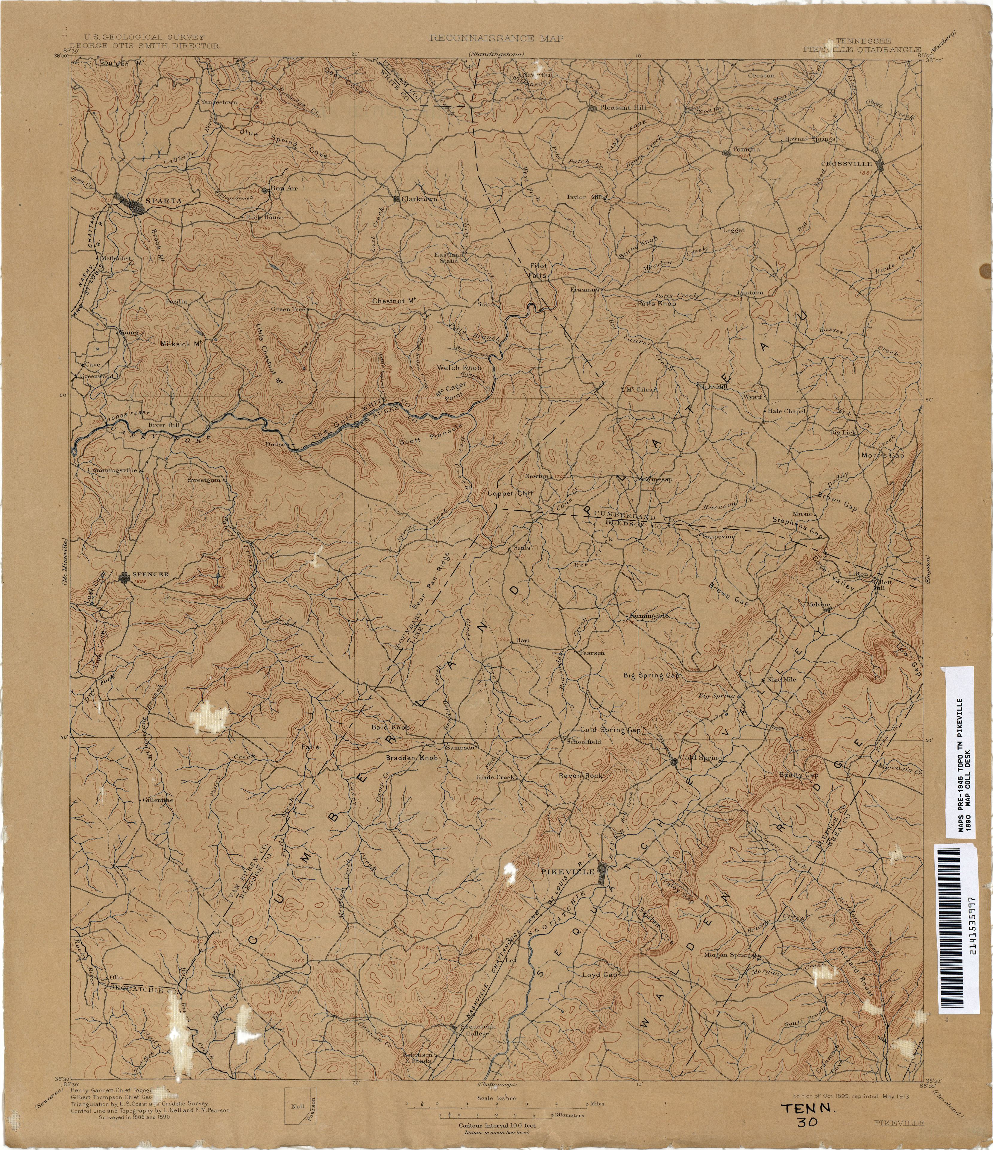
{Click the link and enlarge the map. Scroll up and over to look at the upper left corner where Sparta is. Cave is shown on the map as being on the west side of the river. }
I'm going through one of those spells where I feel snake bit again.
Trying to do a thing only to have it blow up in my face. I try to nail down one part of it only to have another chunk fly to pieces. We made plans to attempt to go to the base of Burgess Falls and Fancher Falls again with Jay. We opted to get a hotel room as opposed to camping. Figured less moving parts. Less chance of failure. Oh how wrong we were. We used our rewards points to get a nice hotel room in Cookeville. We had dinner Friday night at Longhorn Steakhouse.
We slept well. We met Jay the next day at the hotel. We had breakfast together at I Hop. We went to the dock and tried to put in. Only to find that our canoe will not handle three adults.
Kenny was grouchy and upset. I was embarrassed and upset.
Jay was bewildered. I was too. I knew something had to be wrong with Kenny for him to be so hateful to me especially in front of a friend. Finally we packed it up and took Jay back to the hotel. We said our apologies and goodbyes.
I went inside and lay down for a bit to think. I was so frustrated that I was afraid to plan one more thing. I knew something was wrong and Kenny wasn't telling me. It pissed me off also that he sprung on me at the last minute that he was going to drive to Lawrenceburg to buy tires from some lady on Facebook market place.
Finally Kenny convinced me to come on and try to get out and salvage the day. We brought the canoe along as I thought we might need it though as tippy and unstable as that thing is with him in it... I was not sure I'd get back in.
We would attempt to find something I'd wanted to see that evening if we had time or maybe on Sunday. I wanted to visit several features in one area just outside Sparta. I wanted to find the ruins of a former cotton mill. I wanted to
see High Hope Falls which was right near it. I also believed we could possibly find the ruins of the Brady-Haston Bridge and the Cave Community Foot Bridge.
I lowered my expectations a great deal and we set out. I still had the sensation you get when you're waiting for the other shoe to drop. You are so shell-shocked by repeated failures that you just know SOMETHING is going to mess up.
We headed down the road. I felt kinda numb. I wanted to cry, but I just couldn't. The day was strange. It was overcast, but not from the threat of rain. It was the Sahara dust plume settling over our area. Corona virus, murder hornets, riots, race wars, anarchists, now a Saharan dust storm reaching all the way to Tennessee. Shoooooes! Anyone else ready to skip the rest of 2020 and move on to 2021?
We found Cotton Road and headed down what I could tell right off was going to be my kind of road. Shady, quiet, rural country road. Down through the deep dark trees. Right by the road there it was! The ruins of the old cotton mill! We found a place to pull off and went to see it.


Above: one of the walls of the former cotton mill
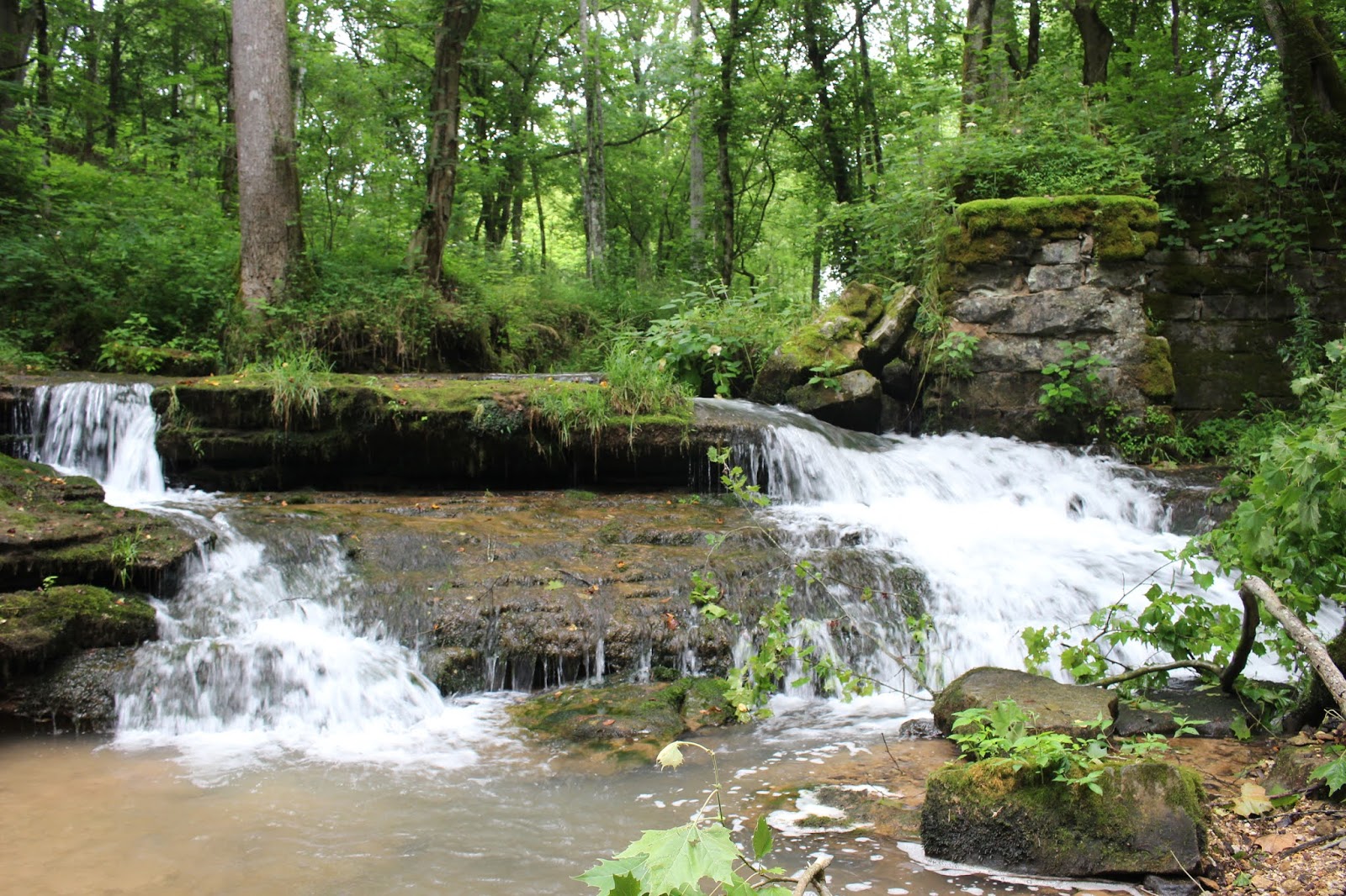
 Above: the spring branch flows from the source, through the ruins, and past the walls of the old cotton mill.


 Below is the spring where this water emerges.


Below: this little mini cascade formed by the spring branch flowing over the broken edges of the ruins

I got in the spring stream and walked right up the structure in the water.
Was it cold? Not terribly, but definitely colder than the Calfkiller which was lukewarm. Moss grew on the concrete sides of the ruins. It has ten channels across the stream. It was dammed at the back where the spring flows out of the ground. It appears to be a healthy spring with a strong flow.


Below is a video of the cotton mill ruins
I was curious as to how a cotton mill worked back in the day. How did it make use of the water. I still don't understand it, but I did find a diagram that shows how it might have worked. I'm sure all of them were a little different in their design.
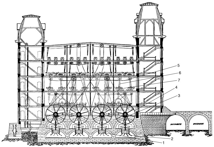
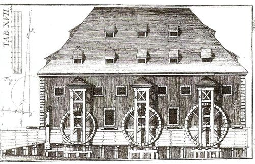
Below is a diagram of the outside of a Boott Cotton mill from Maine.
My friend Vickie Cunningham mentioned that she heard of an old iron works in the area. I told her I knew there were at least two in the vicinity, but I did not know for sure where they were. I later learned that one of them sat in the exact spot where the cotton mill was. It came after the cotton mill. Knowing that makes me wonder if the structure I saw was altered some way to work differently for an iron forge? A walk downstream from the ruins along the river bank showed there were additional manmade structures further on.
High Hope Falls is a 1/10th of a mile downstream. It has a rock wall on the right facing upstream. Down from that is another squared off cement structure on the right stream bank.

Above: Looking downstream below High Hope Falls. There is a path that runs along the bank. You can barely see Kenny in the distance. He motioned to me to come down there.
Below is a video of High Hope Falls
Below: one more manmade structure in the spring branch after the falls.


Above: I loved this view of the beautiful Calfkiller River in the shade of the tree.
Kenny was excited to show me the bridge ruins he'd seen further down. I knew the ruins of the old Brady-Haston bridge were supposed to be down this way. We'd found them! They were quite impressive! The road crossed the Calfkiller River and went east to intersect East Gooseneck Road across from Ward Rd. The nearest crossing now to this spot is the bridge that E. Gooseneck Road crosses.


Above: the bridge abutment where Cotton Road once crossed the Calfkiller River on the Brady-Haston Bridge.
I was pleased that we'd found three out of four things in this area I wanted to visit. We decided we'd put the canoe in the river and try to make it upstream to the site of the old Cave Community Foot Bridge. It was the fourth thing in the area I was curious about. I had long ago seen the remnants of a suspension bridge on a satellite view of a map. I was determined to find out if it was still there. I had the feeling the best way to get to it this time of year was going to be the river by boat. It wasn't that far upstream. We donned our life jackets and set off. The canoe still was tippy feeling, but not sitting as low in the water.
I tried to remain calm. I kept reminding Kenny to BE STILL! He has a very high center of gravity and is erratic. He has dumped kayaks more times that I care to count. We headed upstream in the direction of the old bridge. I realized that the google image I saw could have been very old and it might not even be there anymore. Had this bridge been anywhere besides White County, Tennessee it would have long ago been torn down. The area treasures their long, rich history more than many places. I believed the bridge would still be there.
It was constructed by the Tennessee Electric and Power Company in 1924. It ran from the tiny community of Cave on the west side of the Calfkiller across to what is now the Saddlebrook River Estates subdivision and on to merge with highway 111 nowadays. I don't know what road if any was there back in that day. I'd say if the power company built it there was some type road. I have read there was a clothing factory in the community of Cave. I think it may have been somewhere in the immediate vicinity of where the west side of the bridge was.
It was an old suspension bridge.
We puttered up the green calm waters of the river. The air was still and the air smelled like elder flowers and the slight scent of fish. Not a bad smell. Just a natural smell. Living here in the bright and sunny south we have a sound to Summer. It is the hum of insects singing. We could hear birds chirping. Fish jumped out of the water glistening and silver! Elderberry bushes fluffy white blooms and the deep red orange flowers of trumpet vine draped close to the water. A great blue crane raised and flew from a tree out from us. He glided up the river and settled again.


Above: someone's camp on the river side. It is hard to tell if it is used any longer. It doesn't look like it, but someone is keeping the weeds cut.
We passed beneath E. Gooseneck Road. One thing I really like about the Calfkiller River is that they have taken pains to put up markers along the river banks and on bridges. It is easy to tell where you are this way. Really helps.
This was only my second time ever on this river. I liked it both times.
It wasn't too much longer til we rounded a bend and the remnants of the old foot bridge came in sight. It was still there! Such as it was. It is in tatters, but still hanging on for dear life.


Bridge enters the trees on the west and keeps going. There are towers on either side with cables that held it up.
Below is a short video of our trip on the river and a look at what is left of the old bridge. The Calfkiller River is supposed to be named for the last remaining Cherokee Indian Chief in the area.
We had brought our lunch with us in a marine cooler, but as shaky as the canoe was and as weedy and overgrown as the river banks were we changed our minds. We decided it would be best to wait to eat til we got back to the boat landing. Once we had taken in the bridge we headed into a small cove up from it where we could hear a stream flowing into the river. It really couldn't be viewed because of a log in the way, but it was only a small creek. It was a pretty cove.

We headed back downstream. We saw a bird sitting on a dead tree. I usually have birds fly off as soon as I get the camera in hand, but I got a shot of this one.
It was a green heron! He was not a bit scared of us.

We arrived safely back at the boat access. Three or four people were fishing along the river bank when we got there. We dragged the canoe up on the bank and sat down on some rocks to eat lunch. Once we had that finished we loaded our gear back on the truck. We sat on the tailgate and had watermelon for dessert.
We decided since we were in the area we'd try to find the County House Falls. I'd seen Chuck Sutherland's photo of it. I had a feeling it did not flow year round, but I couldn't be sure. I figured no harm in going to see for myself. County House Road is a super short section of road next to the Calfkiller River.
We pulled over and the GPS beeped "You have arrived at your destination".
No waterfall in sight. We walked up and down the road a little bit to be sure. Either direction indicated we'd gone past it. I slowed down and really studied the rock face in front of us. It had several holes in it. Lots of vegetation has grown up since Chuck took his picture. I closed my eyes and I could hear water dripping in numerous spots all up and down this stretch of bluff. It was dripping from springs, but I now felt sure the waterfall was the wet weather type.
I did see a great patch of Climbing Milkweed. It is a black flower! I hadn't seen any in two years so I was pleased.


Here is what I learned about the iron works: A settler and veteran of the American Revolutionary War found and filed a claim on a large iron ore deposit on either side of the Calfkiller River. He had the last name of Swindle. He sold it to another man by that name, Isaac Swindle who may have been his son, and one Armistead Stubblefield. Those two men built the Harriet ironworks. The property changed hands a couple more times to a Matlock and then to one T.B. Rice who bought it in 1820. He has gotten credit for building the first iron works, but it isn't the case. It later changed hands again and was operational up til near the time of the American Civil War.
Click the link here to read Goodspeed's History of White County. It is interesting.
Two or three accounts I've read in researching mention that salt was mined along the banks of the Calfkiller River. At one time they brought out as much as 50 bushels per day. It came from a salt spring below the site of the old Taylor and Burroughs Mill. Must have been over toward Cave?
Ending this fun trip report with a little music from Creedence Clearwater Revival. A favorite of mine... Green River. I grew up swimming in rivers and walking the cross-ties of the railroad so I can relate to this tune.
** We ended up going home early because Kenny finally admitted how poorly he was feeling. He was in the Emergency Room Sunday morning getting some doctoring**


