Showing posts with label White County. Show all posts

Friday, January 28, 2022

Dry Creek Falls Hike


icicles on a bluff

Icicles on the bluff by Dry Creek Falls


Dry Creek Falls  Hike & Directions 

 Wednesday Jan. 26, 2022


Dana Koogler and Jay Walker

3 mile round trip moderate hike 


Dry Creek Falls Photos 


Dry Creek Falls Directions 


   One of my New Year's Resolutions was to make a sincere effort to be better connected to friends and family.  I have done a good job so far, but it is early in the year.  No time to let up now.   I went hiking with TennGreen and friend Gary Free on Saturday.  We were tired and cold and it was late in the day so we opted to only go as far as Rylander Cascade after our Dog Cove hike.  I talked to Jay on the phone and via Facebook messenger.  We made plans to go visit Dry Creek Falls on Wednesday morning.   It is the perfect time of year for it since these water flow of these falls dries up at times of low rainfall.     I had only been once before, but Jay had never been.  I found out Saturday that Ranger Randy Hedgepath had  also never been so I invited him to join us.  He did not show up Wednesday morning so he either did not get the message or he had things to do.  

     We met at the Lost Creek Parking Area around 9:30 am on Wednesday.

We carpooled down to Rylander Cascade parking area a mere quarter mile leaving Jay's SUV at Lost Creek.  I need not have worried that parking was limited at the smaller lot. We only saw one van there this morning and he left before we even got on the trail.    

    It was a cold day that was only supposed to warm up to a high in the mid thirties, but considering the forecast called for the frigid air of a Nor'easter to descend upon us by Saturday morning ..... the temperatures and weather today were ideal!  It was an uphill climb for a portion of the hike so we would warm up a plenty.  

      The trail to Dry Creek Falls passes Rylander Cascade half mile into the hike. 

We turned aside to see the pretty falls, but the afternoon light is certainly better for viewing it.  The morning's dappled light has the cascade in part shade and part sun making for not the best photos.  It was sure good to be spending time with Jay.

He is a fine person to have as a friend.  His appreciation of nature and it's beauty along with his humor really are a blessing.    We stood for a few minutes soaking up the pretty sight of Rylander Cascade flowing down the lower part of the slope.

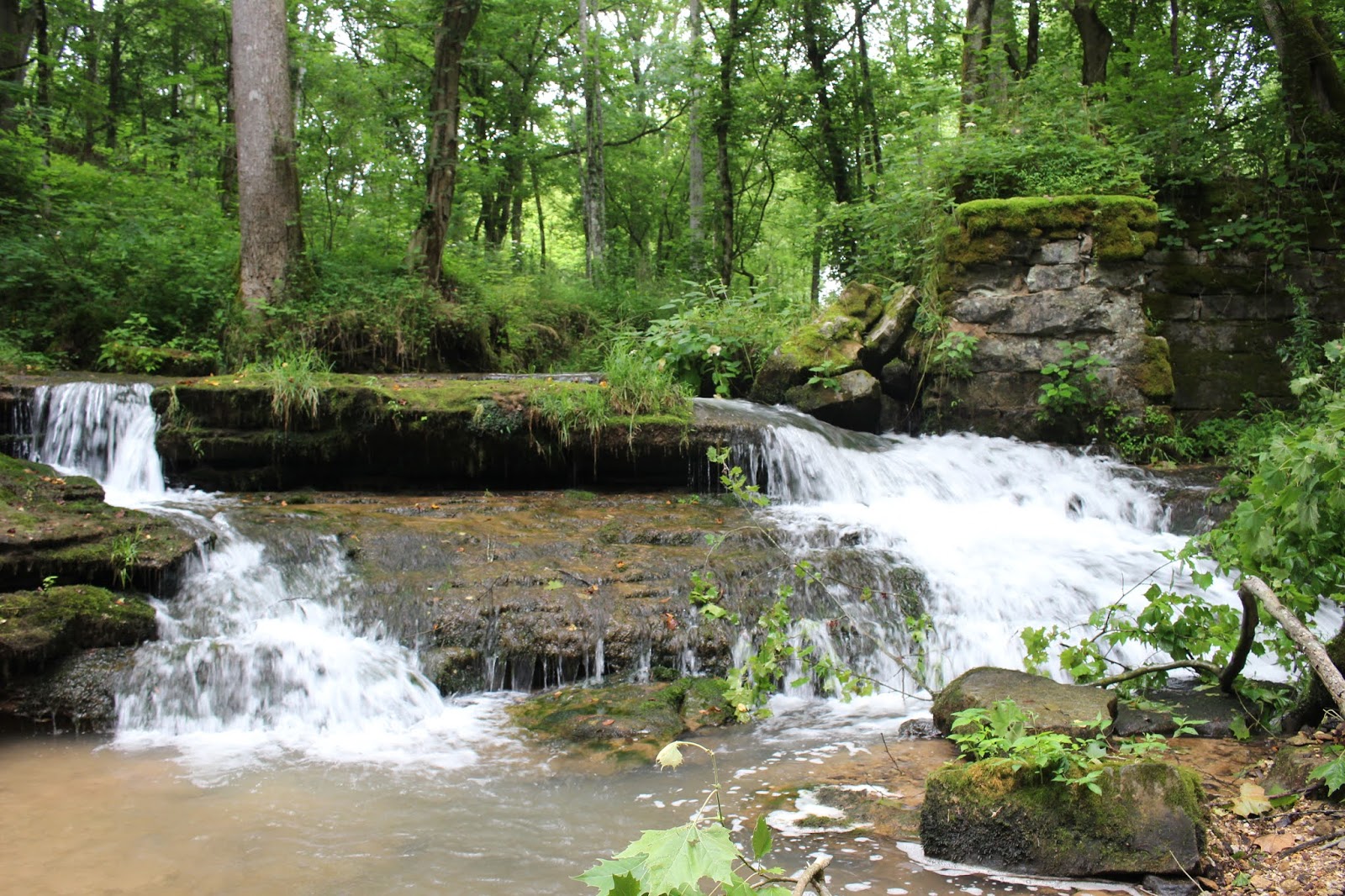
It comes out of the bank above at a spring, flows down as a falls and re-enters the ground at a swallet.  Dry Creek comes down the holler to this point and also enters the ground being drunk up by the same swallet.  The rock forms and spires here at this little cascade are fascinating. They make for a scene that you just don't find anywhere else.  

Rylander Cascade and rock spire

Below is a video of Rylander Cascade

         The hike to Rylander is pretty straight foreward.  It is very rocky, uneven terrain up to this point.   Once we had checked out the cascade we turned right and headed uphill gradually on the path up the holler.  Kenny and I first hiked this several years earlier when there was no trail at all.   It was not the hardest bushwhack we'd ever done, but today having the trail was certainly not wasted upon me.   It was so nice.  This trail also goes in to Virgin Falls from the opposite direction than the usual approach.  The trail parking and use at the upper lot at Scotts Gulf is usually packed and overflowing on weekends.   

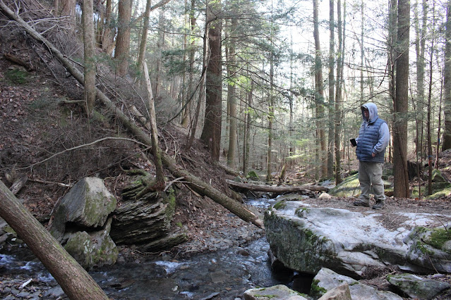
     We  pressed on huffing and puffing a bit as we gradually ascended to ground that leveled off in spots.   It was a merciful relief to have a few steps on flat ground.  The trail is well constructed, flagged and signed.  We crossed a few spring seepages and perhaps in two or three spots the trail was a little muddy.    The forest is comparatively open. It allows for some views of the surrounding terrain.  The area is full of pretty rock formations, pretty trees, and occasional views of Dry Creek below.  Now and then you can see the cascades and rills of the stream as it winds its way down the holler among large boulders.  We saw a few pretty pools of water as well as some slides.  

        We arrived at the split where a right turn takes you on toward Virgin Falls and a left turn takes you toward Dry Creek Falls.   It is only 0.30 miles further past Rylander Cascade to this point.   It is unmistakably signed so no worries about missing it.   From here we were encouraged to see we only had 0.70 miles further to Dry Creek Falls.  The day was cool, clear, blue skies, a few puffy clouds and sunshine trying to beam down on us through the forest canopy of Winter.

   We passed a large round opening of a possible cave on our right!

We did not explore it, but stopped to look in.   The trail here is flat and narrow. 

I noted that the path the trail takes is the course Kenny and I took on our return from Dry Creek Falls.  We stuck closer to the stream on our original bushwhack. This was good from the stand point of a.  you get to see all the pretty spots in the creek and b. you don't worry about missing the falls since it is ON this stream. 

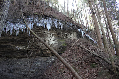
   The odd thing about Dry Creek Falls ? It occurs in terrain that has remained somewhat flat and you would not really expect to find a falls, but all it takes for a waterfall is a stream and one topo line.   It is not a huge waterfall, but quite pretty. It is a thirty five foot falls with an upper falls of seventeen feet high. 

         Soon the terrain smoothed out and our trail trended down toward the creek.

It was at exactly the spot where Kenny and I forded the first trip.   You ford in a spot that is only a few inches deep.  It was above the slides and cascades we could see from high on the trail.   The remainder of the hike is on the opposite bank. The closer you get to Dry Creek Falls the more evident it is why you cannot approach from the right.  The bluff line here gets steeper and pinches you off.  

     The forest has changed now from oaks, hickory and poplar to a hemlock gorge.

It is shady and fairytale like. The stream gets prettier here.  The rocks are green from algae and moss.  Placid pools form along it with small rifles and cascades.

The trail is open and soft underfoot most of the way.  We had one small stream to cross that was an easy step over.   It is a side drainage that flows into Dry Creek from a spring in the headwaters.   

    We heard something mechanized ahead of us like a leaf blower or maybe a chainsaw in the distance.  We never did figure where it was coming from.  

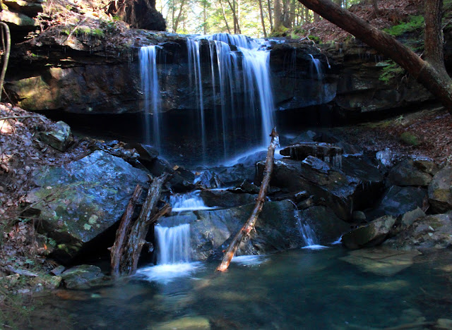
  Soon we approached the falls. We could hear it. I made Jay go first since it was his first time seeing it.   Flat shady woods with a pretty stream is suddenly a nice sized spray of white water spraying over the cut in the bluff!  

Dry Creek Falls silky shot
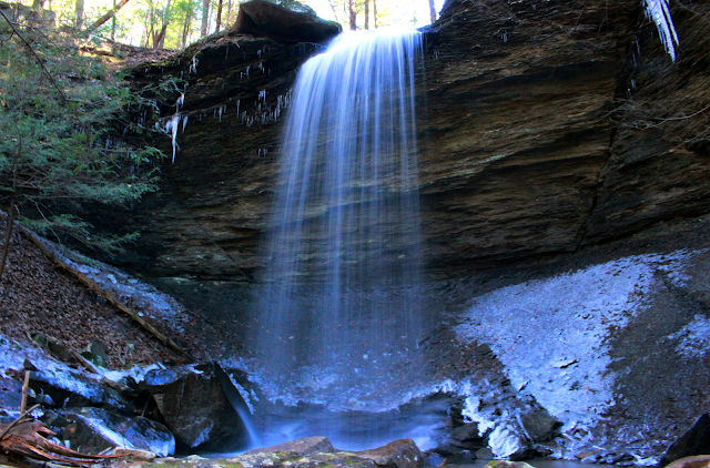
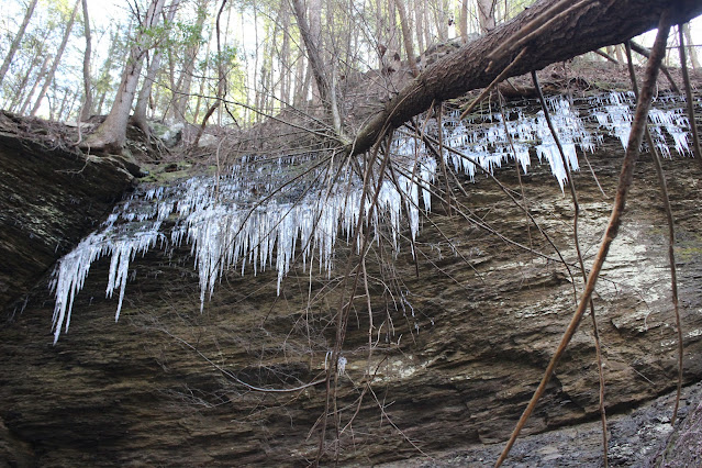
Dry Creek Falls 35 ft. surrounded by icicles and crusts of ice.

Below is a video of Dry Creek Falls


   We spent time enjoying the view here and soaking up the beauty of this scene.
It felt marvelous to be out enjoying life. Each hike and each reconnect with friends restores a piece of my soul I have neglected for months.  I am finding myself and growing healthier with each experience.   I noticed something today I had not paid attention to previously.  There are two fractures in the rock that are somewhat symmetrical. It looks like the rock form that the falls comes over settled creating an inverted  trapezium with its shorter side at the base.  I am guessing water did this, but I am no geologist.   See the image below


Dry Creek Falls with its fracture lines in the bluff

Dry Creek Falls with its fracture lines in the bluff.


Below are a few images of the surroundings. 

jay and the hemlock gorge and pools before the falls
Above:Jay is checking out the creek
icy bluffs
Icicles and downed trees on the bluff
left fracture of dry creek falls
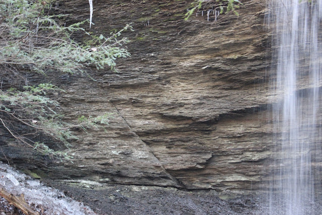
Above: left fracture line at Dry Creek Falls

right fracture line dry creek falls
Right hand fracture line Dry Creek Falls

ice patch back of dry creek falls
Patch of ice by the base of the falls 


    I told Jay the upper falls was a bit further upstream.  I wanted to go see it. I figured trail or no trail we did not walk this far to turn back without seeing it.
It is a mere 250 feet upstream past Dry Creek Falls. Turned out there is a trail .. a good one.. all the way there!  We were delighted at how easy the climb was and the earth under foot was soft duff.  
 
         The upper falls while not as large is as pretty if not moreso.  It is a lovely little cascade with a sparkling clear blue pool at its base.   We enjoyed its beauty and the deep shade of the hemlock forest.  The sun was climbing higher now and it was heading toward noon.  I stood checking out the sunbeams peeping through the forest canopy.  The sun gradually crept to the side of the tree it hid behind. It seemed like a pretty good comparison to what I feel taking place in my heart and mind.  I told Jay how much I appreciated him taking time to come with me.
I realized and said so how when you neglect your friends you lose a little piece of yourself.   He and other friends remind me not to take life too seriously. His sense of humor lets  you know he has figured that out long ago.  He has many facets I am finding.  A deeper faith than I knew.  A man who can think on the serious side of things with wisdom and humor.  A rare and pleasant combination.  

      
upper dry creek falls and blue pool
above: Upper Dry Creek Falls and its blue pool. 
sun beams and forest
The sunbeams peeping down into the hemlock forest over the bluff. Upper Dry Creek Falls. 


    We finally turned and headed back down for our return hike. It was much easier and shorter. No mishaps with anyone falling in the creek! That was good!
The hike back took 45 minutes to an hour. I did not time it precisely. The pace made for easy conversation time.   Jay shared some stories that really blessed me. I need to meet his friend Deb Morgan.  They have been friends far longer and this lady sounds like fun. He says we think a lot alike.  Both deep thinkers.  I hope I get to meet her some day and spend some time with them both.

        We were also discussing looking forward to coming Spring and warmer temperatures.  Planning hikes to see flowers! Yellow lady slippers here we come!

   We have an upcoming family camping trip in March.  I hope we can all get together then since we'll be out in the plateau.  

      We made it back to the vehicle and were ready for lunch. Jay helped me tote the stuff to the side. I set up the pocket rocket stove and heated us up some pasta e fagioli soup. It was good even if I did scorch it a little in the original cooking.  
I told Jay not to attempt to make soup in an enamelware dutch oven. It is just asking for trouble.  I was so impressed with how good it cooked my pot roast I used it for soup. Big mistake.  Low and slow is good... high temperatures are a recipe for disaster! 

      We visited for awhile over lunch, but it was growing colder.  I told Jay I hoped it wouldn't hurt his feelings, but I really did not want to hike in Dog Cove today? He was glad I did not want to. He was tired and cold also.  We packed up the stuff and headed back to his vehicle up the road.  We never saw any other hikers today at all. Not at Lost Creek or Dry Creek.   It was a cold Wednesday in Winter so I guess that is why.    

    I gave my friend a big hug and another thank you.  We had an awesome day.
My knee that had been bothering me was feeling a lot better and I was glad of it.
We parted ways and headed back toward home.  I had thought I'd feel like stopping briefly by Page Cemetery to see the old comb graves, but I did not.  I also did not stop to see the monument to the old house along Highway 70.  I just headed home.
I was cold and a little tired, but very happy.
 
  It also feels good to be writing my blog again.  

Below is a video of Upper Dry Creek Falls.  


Monday, June 29, 2020

Cotton Road and Paddling the Calf Killer River

trumpet vine draping off the trees on the Starr Mtn Rd
Trumpet vine was seen along roadsides,
 and on the banks of the Calfkiller today.


Cotton Road and Paddling the Calf Killer River

Kenny & Dana Koogler

Saturday June 27, 2020


{Click the link and enlarge the map. Scroll up and over to look at the upper left corner where Sparta is. Cave is shown on the map as being on the west side of the river. } 
    I'm going through one of those spells where I feel snake bit again.
Trying to do a thing only to have it blow up in my face.   I try to nail down one part of it only to have another chunk fly to pieces.   We made plans to attempt to go to the base of Burgess Falls and Fancher Falls again with Jay.  We opted to get a hotel room as opposed to camping.  Figured less moving parts. Less chance of failure.  Oh how wrong we were.    We used our rewards points to get a nice hotel room in Cookeville.   We had dinner Friday night at Longhorn Steakhouse.
We slept well.  We met Jay the next day at the hotel.  We had breakfast together at I Hop.    We went to the dock and tried to put in. Only to find that our canoe will not handle three adults.   

         Kenny was grouchy and upset.   I was embarrassed and upset.  
Jay was bewildered. I was too.  I knew something had to be wrong with Kenny for him to be so hateful to me especially in front of a friend.   Finally we packed it up and took Jay back to the hotel.  We said our apologies and goodbyes.

       I went inside and lay down for a bit to think.  I was so frustrated that I was afraid to plan one more thing.   I knew something was wrong and Kenny wasn't telling me.   It pissed me off also that he sprung on me at the last minute that he was going to drive to Lawrenceburg to buy tires from some lady on Facebook market place.   

      Finally Kenny convinced me to come on and try to get out and salvage the day.  We brought the canoe along as I thought we might need it though as tippy and unstable as that thing is with him in it... I was not sure I'd get back in.

       We would attempt to find something I'd wanted to see that evening if we had time or maybe on Sunday.   I wanted to visit several features in one area just outside Sparta.   I wanted to find the ruins of a former cotton mill. I wanted to 
see High Hope Falls which was right near it. I also believed we could possibly find the ruins of the Brady-Haston Bridge and the Cave Community Foot Bridge.

  I lowered my expectations a great deal and we set out.  I still had the sensation you get when you're waiting for the other shoe to drop.  You are so shell-shocked by repeated failures that you just know SOMETHING is going to mess up. 

     We headed down the road. I felt kinda numb.  I wanted to cry, but I just couldn't.  The day was strange.  It was overcast, but not from the threat of rain. It was the Sahara dust plume settling over our area.  Corona virus, murder hornets, riots, race wars, anarchists,  now a Saharan dust storm reaching all the way to Tennessee.  Shoooooes!  Anyone else ready to skip the rest of 2020 and move on to 2021?

            We found Cotton Road and headed down what I could tell right off was going to be my kind of road.  Shady, quiet, rural country road.    Down through the deep dark trees.    Right by the road there it was!  The ruins of the old cotton mill!  We found a place to pull off and went to see it. 

   
 Above and below: ruins of a former cotton mill

         
 Above: ashy hydrangea was the flower of the hour here. Lots of this pretty stuff.
 Above: the old snake doctor lights on a jewelweed stem
Above: one of the walls of the former cotton mill

Above: the spring branch flows from the source, through the ruins, and past the walls of the old cotton mill.
 Below: this little mini cascade formed by the spring branch flowing over the broken edges of the ruins

  I got in the spring stream and walked right up the structure in the water.
Was it cold? Not terribly, but definitely colder than the Calfkiller which was lukewarm.   Moss grew on the concrete sides of the ruins.  It has ten channels across the stream.  It was dammed at the back where the spring flows out of the ground.   It appears to be a healthy spring with a strong flow.   


 Below is the spring where this water emerges.


Below is a video of the cotton mill ruins


     I was curious as to how a cotton mill worked back in the day. How did it make use of the water. I still don't understand it, but I did find a diagram that shows how it might have worked.  I'm sure all of them were a little different in their design.

 Above: the image above shows the walls, the places the water would have flowed through freely and the turbines in the channels at the base.   I counted ten slots in this one so it could have had up to ten turbines.  You can see on the diagram that the turbines turned wheels that were attached to smaller wheels.
Below is a diagram of the outside of a Boott Cotton mill from Maine.

   My friend Vickie Cunningham mentioned that she heard of an old iron works in the area.  I told her I knew there were at least two in the vicinity, but I did not know for sure where they were.  I later learned that one of them sat in the exact spot where the cotton mill was.   It came after the cotton mill.   Knowing that makes me wonder if the structure I saw was altered some way to work differently for an iron forge?   A walk downstream from the ruins along the river bank showed there were additional manmade structures further on.

    High Hope Falls is a 1/10th of a mile downstream.  It has a rock wall on the right facing upstream.   Down from that is another squared off cement structure on the right stream bank. 


 Above: High Hope Falls is a very picturesque little grotto. I love the moss and Summer green leaves.  The rock wall must have taken a lot of effort to construct all those years ago.  Remarkable that it is still standing.
Above:  Looking downstream below High Hope Falls. There is a path that runs along the bank.  You can barely see Kenny in the distance.  He motioned to me to come down there.  

Below is a video of High Hope Falls


    Below: one more manmade structure in the spring branch after the falls.

Above: I loved this view of the beautiful Calfkiller River in the shade of the tree. 

     Kenny was excited to show me the bridge ruins he'd seen further down. I knew the ruins of the old Brady-Haston bridge were supposed to be down this way.  We'd found them!   They were quite impressive!  The road crossed the Calfkiller River and went east to intersect East Gooseneck Road across from Ward Rd.   The nearest crossing now to this spot is the bridge that E. Gooseneck Road crosses.  
 Above: a pretty mossy spot along the river bank near High Hope Falls

 Above: the old Brady-Haston bridge ruins
Above:  the bridge abutment where Cotton Road once crossed the Calfkiller River on the Brady-Haston Bridge.
       
   I was pleased that we'd found three out of four things in this area I wanted to visit.   We decided we'd put the canoe in the river and try to make it upstream to the site of the old Cave Community Foot Bridge.  It was the fourth thing in the area I was curious about.    I had long ago seen the remnants of a suspension bridge on a satellite view of a map.   I was determined to find out if it was still there.    I had the feeling the best way to get to it this time of year was going to be the river by boat.   It wasn't that far upstream.  We donned our life jackets and set off.   The canoe still was tippy feeling, but not sitting as low in the water.

     I tried to remain calm. I kept reminding Kenny to BE STILL! He has a very high center of gravity and is erratic.  He has dumped kayaks more times that I care to count.   We headed upstream in the direction of the old bridge.  I realized that the google image I saw could have been very old and it might not even be there anymore.   Had this bridge been anywhere besides White County, Tennessee it would have long ago been torn down.   The area treasures their long, rich history more than many places.   I believed the bridge would still be there.

      It was constructed by the Tennessee Electric and Power Company in 1924.  It ran from the tiny community of Cave on the west side of the Calfkiller across to what is now the Saddlebrook River Estates subdivision and on to merge with highway 111 nowadays. I don't know what road if any was there back in that day.  I'd say if the power company built it there was some type road.  I have read there was a clothing factory in the community of Cave.  I think it may have been somewhere in the immediate vicinity of where the west side of the bridge was.
It was an old suspension bridge.  

     We puttered up the green calm waters of the river.  The air was still and the air smelled like elder flowers and the slight scent of fish.   Not a bad smell. Just a natural smell.   Living here in the bright and sunny south we have a sound to Summer.  It is the hum of insects singing.  We could hear birds chirping. Fish jumped out of the water glistening and silver!   Elderberry bushes fluffy white blooms and the deep red orange flowers of trumpet vine draped close to the water.   A great blue crane raised and flew from a tree out from us.  He glided up the river and settled again.   
 Above: the prow of the canoe against the backdrop of that green river
 Trumpet vine hanging down
Above: someone's camp on the river side. It is hard to tell if it is used any longer. It doesn't look like it, but someone is keeping the weeds cut.  

    We passed beneath E. Gooseneck Road.  One thing I really like about the Calfkiller River is that they have taken pains to put up markers along the river banks and on bridges. It is easy to tell where you are this way.  Really helps.
This was only my second time ever on this river. I liked it both times.
It wasn't too much longer til we rounded a bend and the remnants of the old foot bridge came in sight.   It was still there!  Such as it was.     It is in tatters, but still hanging on for dear life. 

 above: first glimpse of the old bridge. Click the image to enlarge to full size for a better look.


 Above: remnants of the Cave suspension bridge. I can't help wondering how many area residents actually used this? Impossible to really tell from this picture, but it is quite high off the water.  A good thing in that it was high enough to avoid damage from flooding, but it would have made crossing it kinda scary.
 Above: I am looking straight up into what is left of the bridge.
Bridge enters the trees on the west and keeps going. There are towers on either side with cables that held it up.  

Below is a short video of our trip on the river and a look at what is left of the old bridge. The Calfkiller River is supposed to be named for the last remaining Cherokee Indian Chief in the area.   


       We had brought our lunch with us in a marine cooler, but as shaky as the canoe was and as weedy and overgrown as the river banks were we changed our minds.  We decided it would be best to wait to eat til we got back to the boat landing.   Once we had taken in the bridge we headed into a small cove up from it where we could hear a stream flowing into the river.  It really couldn't be viewed because of a log in the way, but it was only a small creek.  It was a pretty cove.

above: shimmering water in this cove where another stream enters.


     We headed back downstream.  We saw a bird sitting on a dead tree. I usually have birds fly off as soon as I get the camera in hand, but I got a shot of this one.
It was a green heron!  He was not a bit scared of us.

Above: green heron sits on a dead tree

      We arrived safely back at the boat access.  Three or four people were fishing along the river bank when we got there.    We dragged the canoe up on the bank and sat down on some rocks to eat lunch.   Once we had that finished we loaded our gear back on the truck. We sat on the tailgate and had watermelon for dessert.
We decided since we were in the area we'd try to find the County House Falls. I'd seen Chuck Sutherland's photo of it.  I had a feeling it did not flow year round, but I couldn't be sure. I figured no harm in going to see for myself.   County House Road is a super short section of road next to the Calfkiller River.

     We pulled over and the GPS beeped "You have arrived at your destination".
No waterfall in sight.  We walked up and down the road a little bit to be sure.  Either direction indicated we'd gone past it.  I slowed down and really studied the rock face in front of us.   It had several holes in it. Lots of vegetation has grown up since Chuck took his picture.   I closed my eyes and I could hear water dripping in numerous spots all up and down this stretch of bluff.   It was dripping from springs, but I now felt sure the waterfall was the wet weather type.
I did see a great patch of Climbing Milkweed. It is a black flower!  I hadn't seen any in two years so I was pleased.

 Above and below: climbing milkweed's black flowers!
 Below: I also saw lots of hop hornbeam trees along the base of the bluff.

 Above: one of the now dry holes County House Falls sometimes shoots from.
Above: a section of old abandoned road at County House... heading down toward the river.


     Here is what I learned about the iron works: A settler and veteran of the American Revolutionary War found and filed a claim on a large iron ore deposit on either side of the Calfkiller River.   He had the last name of Swindle.  He sold it to another man by that name, Isaac Swindle who may have been his son, and one Armistead Stubblefield.   Those two men built the Harriet ironworks.  The property changed hands a couple more times to a Matlock and then to one T.B. Rice who bought it in 1820.  He has gotten credit for building the first iron works, but it isn't the case.  It later changed hands again and was operational up til near the time of the American Civil War.

Click the link here to read Goodspeed's History of White County. It is interesting.

  Two or three accounts I've read in researching mention that salt was mined along the banks of the Calfkiller River.  At one time they brought out as much as 50 bushels per day.   It came from a salt spring below the site of the old Taylor and Burroughs Mill.  Must have been over toward Cave?

  Ending this fun trip report with a little music from Creedence Clearwater Revival. A favorite of mine... Green River.   I grew up swimming in rivers and walking the cross-ties of the railroad so I can relate to this tune. 

** We ended up going home early because Kenny finally admitted how poorly he was feeling.  He was in the Emergency Room Sunday morning getting some doctoring**


Sunday, February 8, 2015

Virgin Falls Solo Hike

Virgin Falls Solo Hike

Dana Koogler 
Saturday Feb. 7, 2015

Total hike distance 8.8 miles 


     We were supposed to go riding this weekend.   However with Kenny's work schedule I've learned to have plans A, B, C, and D.  Always have a backup plan.  He promised me we'd go the next weekend and make a LONG weekend of it.  My backup plan was a solo hike to Virgin Falls.
I invited others to go but had no takers.  It was a good backup plan because I felt reasonably comfortable going there alone. I had never hiked there alone before, but had made two previous
trips and knew the area pretty well.   It is also visited enough I knew I would not be truly alone.

        I committed myself to an early start and that this time I would make the side trip to 
the overlook.    I kept both promises. I was on the trail by eight o'clock a.m.  I parked along the road because I did not want to get blocked in. I also felt like the backpackers would be the most
logical persons to use the parking area which is rather small.   The entire hike took me eight hours.   I had plenty of time for lollygagging.   Virgin Falls State Natural Area lies in Scott's Gulf
in White County, Tennessee.   I have decided to get serious and visit all the land forms in 
Scott's Gulf.    I want to eventually put together a photo gallery of that area.  

       Today would be a good day to get the jump on that.  I will get it out of the way to say 
Yes, I am a little jaded about Virgin Falls.  Detractors from it for me are:
  • I have been a couple times before
  • It is heavily visited
  • I have found numerous other places with waterfall caves that offer solitude

  I hate it when I feel this way about a place.   I have thought of solutions and here are some
ways I think I can make this better:

  • Hike it in a different season than I ever have before. 
  • Hike it from a different direction than ever before
  • Do partial hikes into the area and focus on visiting some of the lesser noticed spots.
  • Take someone back who has never been before

 We plan to hike it from the Caney Fork River during warm months when the Caney Fork
waters go down enough to ford safely.   We'll go down to Davis Cemetery and hike in from there or Big Bottom.   The waterfalls can dry up so much during Summer that it would make it really hard for me to push myself to hike all that way to see them with a piddly flow.   A shorter hike and a swim in the river would help though. 

     Hiking down through Virgin Falls starts off flat and through open woods.
The first significant thing seen along the trail is Big Branch Falls. It is about 15 ft high.

Big Branch Falls is very scenic. 


    I continued down the trail past the Cable Crossing Campground. I had a brief moment of trail confusion.
I did not want to truck right through the campsite, but I did not see where the trail went besides there?
I finally gave up and headed through the camp site since the fellows there were breaking camp anyhow.
I stopped to ask them where the actual trail was and they pointed out to me that it was directly below the camp site, yet it was possible to just go straight through the site and merge with the trail.  The camp site is particularly desirable. It is flat, shady, plenty of water and during times of ample rainfall there are several small cascades right there at the campsite!  It is in close proximity to the overlook spur as well.
Further down the stream is a series of nearly continuous deep blue green pools, massive boulders, and 
attractive cascades.   Once you get past Big Laurel Falls there is no more stream or water until you come to Sheep Cave and falls!  

     I turned off to the spur trail for the Overlook and hiked the moderate 0.5 miles up there.
It was well worth the effort to get there.   It was not like I had imagined. I knew there were camp sites up there, but I figured you'd have to come all the way down to the stream at the main trail to obtain water.
It turned out not to be the case.  I can't speak to the entire year. Maybe the spring branch dries up, but 
it was flowing well today and it was a short distance back down the trail from where you set up tents!
The forest up there is open pine woods and quite pretty.  
View from Martha's Pretty Point


    Back down on the main trail I turned right and went on down toward Big Laurel Falls. 
It was six or seven years since my last trip here. I got past that spot where ice accumulates on the rocky slopes of the trail.  I was relieved to be beyond that.   It always makes me uneasy, but  especially today hiking alone.    I arrived at Big Laurel Falls and found that a small crowd was accumulating there.
I found it hard to get to a point where I could get photos of the falls minus the people in the photo and minus the spray.   
Big Laurel Falls spills over a ledge and its flow entirely disappears into the cave behind it.  
Below here there is no stream to flow alongside you on the hike.   BTW-- there is a SWALLET.. a small one in the stream heading down from the Overlook Spur Trail to Big Laurel Falls.
It is easy to see from the trail if you look closely.  

    After a brief rest here at Big Laurel Falls I continued down the trail with a large group of hikers who were all going the same way. They were very nice people and I hiked the rest of the way in with them.   Next stop was Sheep Cave and falls.


Top-one portion of Sheep Falls
Bottom--One entrance of Sheep Cave. I went in and waded the creek, but forgot to bring a light today.  


      We motored on toward Virgin Falls taking the upper loop to get there.
It is 0.3 miles longer, but is more gradual and less rocky a trail.   I could hear Virgin Falls long before we reached it.  I could tell from the roar there would be a ton of water coming over the falls.
Sure enough there was more water and spray coming off that falls than I'd seen on previous trips.
It is impressive and very pretty.  It is a little dismaying to try to enjoy the spot with gaggles of people and there were plenty.   Especially the climbers around the rim of the falls.  It makes it hard to get a pretty photo and makes me uneasy that I'm going to watch someone fall to their death.  Cell service does not exist in Scotts Gulf and consequently help would be a long time coming. A fall from the top of those falls would mean certain death.  People have fallen from Rainbow Falls in Gorges State Park and survived going over the falls.  The difference is that there
is a plunge pool at the bottom to catch you giving you slightly better odds of making it.
Virgin Falls has no plunge pool to cushion your landing.  To the dummies who stand out on the edge of the falls.. I have this to say.    Nature is supremely indifferent to whether we live or die.  And long as *I* am safe and sound... You go ahead and gamble with your life. I don't care.
Pull up the ladder, Mack. I'm on board. 


Virgin Falls is 110 ft high


     Many of the other hikers went off in other directions including those in the group I had arrived here with. I used the time to eat lunch at last. I also used the time and the opportunity to get some photos and video footage without people in it!   

    Once that was done I hiked back out. I tried the lower loop with two nice ladies who were hiking out.  I hiked as far as 1/2 mile back to the big intersection with them. Once I'd gotten there I was ready to sit down and finish my lunch.  I also came out of some more layers of clothes.  I began having problems with my left lower leg.  It felt really funky down in my ankle. It was throbbing
like a rotten tooth.   I finally took some advil when I got back to Big Laurel falls.  I knew once I got that uphill climb between Big Laurel Falls and the overlook spur done I'd have the worst over.
I sat down at the campsite and removed my boots and a charley horse hit me so bad in both legs.
Some young women were coming by and I must have looked like I was ready to die.  They did not want to leave me there. I appreciated the concern, but I did not want to talk I was hurting so bad.
I finally assured them I was going to be OK and they went ahead.    I really was ok in a little bit.
I made up my mind if I wasn't a whole lot better by Monday morning I would go to the doctor and get checked for a clot or an electrolyte imbalance.  

     The last mile out was a breeze. Mercifully flat and the woods open and cool. The evening sun shining on my shoulders.   The air fresh.   I was glad to have come today. Below the video I will see what's in my crystal ball of the future. 


In Magicmomma's Crystal Ball of the Future I see:

    Future trip up to Virgin Falls from the Caney Fork River
Hiking to Evan Falls and Gunstock Branch Falls
Hiking to all the falls and overlooks in the Polly's Branch vicinity
Hiking to Rogers Creek Falls (2) and Buzzard Roost Rock
Exploring arches, caves, and waterfalls in Fentress county.
Finding Spring wildflowers, waterfalls, sinkholes in Scotts Gulf

**Strike through denotes trips that have since taken place. Not bad 9/18/18 and I've done four out of seven.