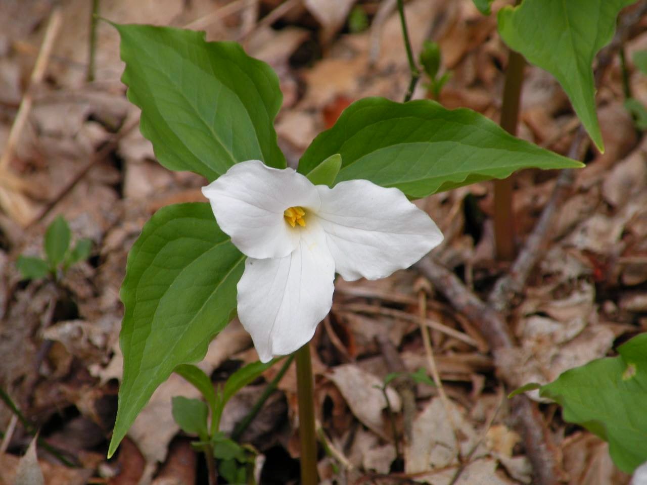
Friday, May 9, 2014

Jamestown Camping Trip --Day 1 --Bills Creek, Lost Cane, and Big Sunk Cane


Furrowed Wake Robin
Jamestown Camping Trip--Day 1
April 24-27, 2014
Dana & Kenny Koogler
Maple Hill RV Park
Pictures are here: Jamestown Camping Photos
   

     We had been looking forward to taking our first camping trip
of the season.  Things finally fell together for us to do just that.
We managed to be able to leave by 5 pm Thursday for a long
weekend of relaxation and fun.   We had packed and prepared
Wednesday evening.  We were there by 7:30 pm Central time.
We finally got to meet Klaas, one of the owners of the campground.  We'd met Betty many times. It was great to see her again. It was wonderful to finally meet her other half! 
They are a fun spirited couple. I look forward to many more years
of visiting with them.  Jamestown and Fentress County have become a home away from home for us.


   We set up the trailer and forced ourselves to get back out
to town.  We went by Wal-Mart and did our weekend grocery shopping.  We checked the weather before going to bed. It called
for rain during the night and in the early morning.  I woke once during the night for a moment. It was pouring rain. It sounded great on the camper roof.  Its a good feeling to be in warm and dry with it raining around you.   
    Morning came and it was still a little rainy.  We had another downpour or two.  The worst was over by 9 am or so.  We took time to eat a good breakfast.  We needed non ethanol gas for the RZR so we took time to find the Farmers Co-op.  He bought the gas we needed. We had never been in the store before. Wow! It was nice.  We heard the rain beating down on the galvanized metal roof of the Co-op! We leisurely checked out the store and visited with the friendly employees.Kenny bought a new leather belt. He purchased me a ladies dri-wick hiking t-shirt.   
The rain let up so off we went. 
       

   We parked at Woo Hoo Holler and checked on Sharon's
shabin and so forth. Everything seemed to be in order.  We headed out to Bills Creek to start our day.

    Bills Creek was bright green and everything dripped with rain.  Mud ran in the creek and down the ditches.  We passed yards with dogs, chickens, guineas and hogs.   I began seeing wildflowers along the edges of the road.   


Bills Creek after a hard rain


Wild Columbine flourishing on the chalky limestone rocks of Bills Creek

     I love this wild and dark place of hemlocks.

      I was having a good time, but we had so much to see and explore we decided to cut this part of the Bills Creek ride short. Kenny had seen another side trail he had always wanted to find out where it went. I was game so we headed in that direction.  The rain had not come back but things were still muddy and dripping.   We took a hard right turn down the hill on another gravel road and followed it around behind some houses. On and on it went ... for awhile.  It was a pretty spot and I was really liking it, but as often happens... the trail finally played out. Not before Kenny had gotten out and built a "bridge" of rocks to fill the gap of a large wash out.  The mountain was steep here and sliding off would have been disastrous!  Yow!   The woods was beautiful and green and smelled fresh of rain.
The slopes above us were lined with trilliums pink and white, purple phlox, and yellow trilliums also.


Top-- Slopes covered in Spring ephemerals
Bottom-- view of the newly explored side trail on Bills Creek.

    We continued on the new trail as far as we could. The path deteriorated and then disappeared altogether.   Kenny found a spot to turn us around and got us out of there. We decided to head to Lost Cane next.

        We wanted to see the wild and wooly Lost Cane to learn what it would be like this time of year?
Last Spring we'd explored it and found six waterfalls and loads of wildflowers.  It was Spring again, but it was a full month later than the previous year.  We found the intersection at the top of the mountain and headed down down down into the cane.   It was pretty and green.  It was more grown up than last year.   It was not long before we got to the first waterfall. It was barely a trickle even after last nights and this mornings hard rain.  The one below it was not running at all.
We did not stop, but continued deeper into the cane.   We could hear water so we got off the RZR to see what was around. The stream to my right was running and while it was small, it was quite pretty.
We continued and passed the third and fourth waterfalls. The third one was not running at all.  The fourth one was gushing out of the ground.  We had to stop and clear downed trees a couple times.
We finally came to the fifth and sixth waterfalls.  Waterfall #5 was not running at all. It depends on the stream of surface water. Waterfall #6 was flowing very prettily. It comes from a spring in the ground.  it only flows a short distance before it goes back into a swallet.  I am posting a video
with no music added that illustrates the quiet and wildness of that area. 


Lost Cane Falls and caves in Spring. 

     It was turning out to be a wildflower paradise just like the previous year, but different flowers!
Still some trilliums, but not the huge masses of the same flowers.  This year we saw the area dominated by deep purple blooms of dwarf larkspur, white Canada violets, yellow trilliums, phlox,
trillium sulcatums deep maroon or black blooms, green and brown and burgundy toadshade trilliums. I almost left out prairie trilliums in two shades, brown and maroon.
The cane was quiet as a church except for one bawl that went up sounding like a bear.
Dry washes like cobblestone paths.  Looming moss covered rock forms that are scattered around reminding you of an ancient city now reclaimed by the earth.  I like the solitude of this place.
I also love it that it is remote, isolated, in the depths of the mountain and seldom visited.
 We stopped and ate lunch in the quiet and warm sunshine.


Top.. purple dwarf larkspur and white Canada violets among moss boulders of Lost Cane
Bottom-- Waterfall #6 flowing from a spring and in about 20 feet or less goes back into the ground.


     We continued on deciding to brave the rocky end of the trail. It would be far shorter and bring us out close to the truck.  We planned next to head across the county to visit Big Sunk Cane Falls.
I was determined to find it today.  We had to work our way past downed trees. Past briers encroaching heavily and duck under some low bridges formed by other fallen trees.
Kenny spotted a side path going up to the left on our way out. He decided to try it. I am so glad he did!  We found a much better alternative around the worst of the rocky section of trail.  We got out of there sooner than expected thanks to this!   We loaded up the RZR at the truck and parked the wagon
behind the locked gate at Woo Hoo. We would not need it again today.  We'd be hiking now.

     Big Sunk Cane is at Green Pond way across the county and into Overton County.  One of those
places where they ain't no good way to git thar from hyere.    We opted to drive route 52 to Hwy 85
as it was a more direct route on a better road. Better being a relative term especially when you talk about route 85.  If you have driven it you know what I'm talking about!  It has some pucker factor.

     Driving along toward our destination we had to pull over because I spotted a waterfall!
Posted signs dotted the terrain around it.  I decided my vision problems and recent brain problems had me WAY messed up and I just did not see that stuff.  I climbed down the bank and made my way over to this beautiful falls cascading down the bank and joining the roadside stream.  The falls doesn't have a name that I know of. It is in Pickett County.


 Top--beautiful mossy roadside stream
Bottom--oh so tempting.. trespassing trip material.. un-named waterfall.. not on the database!

     Kenny dropped me off. Parked the truck down the road. He walked up to meet me and check out the trespassing waterfall. He told me we needed to next go a short distance down the road where he parked. He had found yet another pretty cascade we'd never seen before!  We went there next and it was even worse to get down the bank to reach.  The dirt was slippery, wet and a crumbling shale slope.  I was surprised I did not fall or end up rolling into the creek, but I made it!
Roadside cascade in Pickett County. Also trespassing. Also NOT on the database. Woot woot!
The afternoon sun made everything glow.  Clearly I have need some more practice with the new camera and filters!

       We clamored back up the bank and into the truck. We didn't get busted. I count that a victory.
We enjoyed the pretty scenery on the way to Green Pond to reach Big Sunk Cane.  We had no idea what that would be like!

The Hunt for Big Sunk Cane
 We had looked for this waterfall once before when we were in the area.  We followed the directions
exactly.  We measured off the distance on the odometer precisely.  When we arrived at the pull over spot there stood a house in a curve at the start of a long rectangular field.  It was as described except for the house.  We were bummed figuring something had just changed since the guidebook was published.  I had spoken with someone about how they reached the falls and they told me they went to a gate past the house and parked and walked from there.  We passed the house and continued to the next place there was a gated entrance.  We took the waypoints for the falls and headed out in the direction indicated.  We crossed a stream and headed to the back of a field.  The GPS now had us climbing a red mud hill.  Up and up we went.  We could see around the bend below us.  The stream had a small cascade there.  The GPS still pointed in the opposite direction and we knew it was pointing correctly.  Something was wrong.  Seriously wrong. We were having one of those moments of being like the Hebrew Children wandering in the wilderness.  Disgusted we started walking back.
It was hot and humid and we knew we were way off. 
       Back at the truck we turned on the AC.  We got something to drink. We turned and started back toward where we'd come from.  I was a little down hearted.  Kenny and I spotted a pull off trail into the woods. It was an old logging road.  We decided to chance it to see if that was a trail that led to the falls?  We did not have long to figure this out. We also did not want to get busted on someone's property. The road was muddy. We could tell the falls was back that way. We were closer now!
He parked the truck and we got out and started walking.  We came to the edge of a bluff and had to figure a way down. We got off the bluff on a path that looked very sketchy.  It was steep, slippery, and made me very uneasy.  Thankfully we were soon down at the edge of the woods which gave out
onto the field.  The native cane has been cleared here except for the edges.  It was only about three feet deep and we were walking on a grassy path. 

Crossing the field at Big Sunk Cane. Such a pretty place!

    The trail enters the forest again at the far side of this field.  The evening sun is slanting and sinking lower.  It lit up the woods and the wildflowers like gold!

Trilliums illuminated by evening sunbeams just before the waterfall. 
   After a very short walk over mossy, rocky ground in the woods we arrived at the edge of the cave the waterfall drops into.  The falls is extremely pretty. The water gushed over the rocky limestone face.  It was also lit up by the same golden evening sun rays. 
 Golden view of the sun on Big Sunk Cane Falls.

Below is a photo of it adjusted for the sun.


Big Sunk Cane in a different light.  I miss my photo editing soft ware.


   It was a magical place. I was thrilled to be there at last.   We had finally found it. 
We decided we could not linger long since we were losing the light.  We were tired and hungry.
Sweaty. Ready to go home.  Kenny very heroically said the best thing to do was for him to go back
up the bluff the way we came down. He'd have me go straight out through the field and bring the truck around to pick me up.  I'd have an easier walk out and we'd know exactly where the road access point for this trail was.   He is so limber and fast he got out about the same time as I did.
I heard the truck start up and had to make smoke to get there same time as him.

   Apparently what has taken place is that the access is now gated.  There are two canes almost identical to look at them. The first one is the correct one. The second one at the given mileage is someone's yard.    Parking here is a real problem. There really is no place to park. If we come back we'll have to try to pull into the woods again. I want to come back when we have more time to explore.  It is worth noting that Sharon Blackstock Sessions managed to access the falls from Roger Norrod Lane... on the OTHER side of the bluff. A feat I'd have thought impossible. I don't know how she pulled that off, but she did! 

       We loaded up and headed back to Woo Hoo. We hitched up to the RZR and back to the campground we went.  We were treated to a beautiful sunset on the ride home.

Sunset from Hwy 52. 


Just a short distance further we stopped to take a glance at a roadside waterfall along route 52.


Notice the pink glow on the falls and the rocks? This is from the colors of the sunset on it!
We have been by here many times and have never seen this little waterfall lit up by the sunset before!

     Back at the camper we got cleaned up and prepared dinner. We had Caribbean jerk pork chops.
Parmesan noodles, and corn on the cob.   We were famished.   After dinner we rested and
watched tv and prepared for the next day.  We planned to go four-wheeling at Pickett State Forest and over into Kentucky. We also got up to our usual Barney Fifing things out.  More on that in Part 2 of the Trip Report.


Wednesday, May 7, 2014

Tallassee Spring Wildflower Hike

Canada violet near the gate
Tallassee Wildflower Hike
Dana Koogler solo
Hike distance 3 miles approx.
**I lost most of my photos from this hike
when my computer crashed. I had just enough to post
a trip report using current images. I am including a link
to hikes and rides of the past. **
Pictures are here: Tallassee photos
   I enjoy hiking with people.  I also enjoy time to myself.  I find that time alone
 out in nature is vital to my health, sanity and creativity.   I like seeing new areas, but
there are times when a safe, familiar place of quiet is a real blessing.  I decided it was time
for a solo hike to an old familiar area of great beauty... down the road to Tallassee.
It is only about 25 miles from the house.  I loaded up the jeep with snacks and drinks.
Camera gear. Water shoes.  Hiking boots. Trekkers. And off I went!
Foothills Parkway was amazing today.  I had enjoyed the views but finally I just could not bear it any longer. I pulled over and took this photo.  Foothills Parkway West  rambles along the spine of Chilhowee Mountain from Walland down to Tallassee. It terminates at Chilhowee Lake.    It may some day run from Wears Valley to Tallassee. Work continues, but it has since
the 1960s!   Puts me in mind it is a government boondoggle.
           
    Hiking at Tallassee involves numerous crossings of Cochran's Creek.
It is what you start out with that the gate!! Back when we leased the land we could open the gate and drive through the creek avoiding the need for that first, deep, wet foot crossing.
Now there is no way to avoid it.  Thus the water shoes. I plowed through the stream up to my calves.  Only a short distance further and I knew I'd have to ford at least two or three more times. I chose to leave my water shoes on.
I tied my boot laces together and slung them over my shoulder and rambled on.
It was a decision I would come to regret. 
   I had not gone far until I came to another place I always turn aside and wade the creek and check out the flowers.  The stream is particularly pretty and wild. It winds like a ribbon through the trees.  It has always pleased me to stand up on the bank and see the curves of the stream through the forest as it carves out where it wants to go.  The stones in the stream
are colorful and just pleasing to my eyes in all that clear water!

  
     I had beautiful weather today. The skies were bluest blue and clear.  The sun shone kindly on me.  A light breeze fluttered the leaves.  The air smelled of flowers.  The stream flowed past babbling and sparkling.   I noticed the beavers had reconstructed their dam further upstream!
The flood waters had washed it out before so they had to re-engineer it!  
        I made my first turn at the big dogwood tree.  White dogwood blossoms shone in the sun.
I began to see some more wildflowers.  I stopped to photograph a pretty patch of blue phlox.
I was down on the ground when I heard a shuffling by me and felt movement.   It was a black
snake trying to get out of my way!  He went  his way and I took his photo. 

        My encounter with the snake did not stop me from wallowing in the experience today.
I was soon back laying on the ground in order to get pictures of Catesbys trilliums which are
hard to see. The blooms dangle below the leaves.  I am not above putting a twig against the stems to get them to cock back a little for me to have a better angle for a photo! 
I saw a few of them and some were crisp pure white and some were pink.


Two color variations of Catesby's Trillium.


   I continued ambling up the old rocky trail. The stream beside me was especially pretty.
It is a series of long, running cascades one after another.   I took pictures of one on
my way back.  I no longer have the photo, but here is a short video of it. It is so nice.  I had never climbed down
to this spot before. 


Pretty cascade at Tallassee.  I think this is a tributary stream of Cochran's Creek.


        I forded the stream again in a deep place at the crest of the hill.  I was pleased to see
that the huge downfallen tree was still there, but had mostly been removed!  I could at least ford without wiggling my way through its branches.   The crossing here is deep and slippery.
Adding the branches of a fallen tree did not do anything to make it simpler.  A short distance further I passed an old rock wall and the site of a structure.  I passed another series of scenic
cascades.  The ferns and moss and flowers here are so lush. 

      I continued on the sardine can cascade.   I noticed the dirt patch in front of the cascade
was a mat of soft, sandy earth.  Here on this spot of earth grew great numbers of pink and white spring beauties and purple violets.  A huge log had split open and filled with dirt.
It brimmed with white violets and green moss.   Life takes hold and flourishes in this place!

         I decided today the first place I'd go was the big open meadow.  I ambled along crossing
the creek a couple more times.   I soon found myself at the meadow.  It was great to see as it seemed a long time since I'd been there. 

Tall, tall trees!!  My camera only shows a portion of the grandeur of this wild meadow.
It was such a perfect day. The tall tree in the center and some of the others with palest green appeared silver in the light.  

    I grew up in a rural area of Virginia called Barren Ridge.    It is  a pine barren.  It is part of the Shenandoah Valley.  It  was wide open and quiet and pretty.  I always liked it there.  A common sight there was sage fields.   I come to Tallassee and hike and it is similar to Barren Ridge.  I feel right at home in a sage field with the birds singing.  I hiked all the way across the meadow.  I saw loads of purple birdsfoot violets and hot pink dianthus in the sage brush.
I re-entered the woods on the far side and hiked about 1/2 mile further.  I turned and headed back.   The walk back across the meadow provides a different perspective.

 I stopped and just drank it all in.   I love Spring here in this place.  There is something unmatched about the new pea greens of spring, silvery and shining against the deep, dark hunter greens of the pine trees that makes my spirits soar!   I could hear the bird songs. A hawk flew and circled in the skies above.  Far at the edge of the meadow I could hear the faint trickle of the creek.  I enjoyed a slow hike back in the direction I'd come from.   I stopped and closed my eyes.  I could hear no sounds of man.  Quiet except for the created works of God.  Nothing the hand of man could ever make could equal the splendor of the natural world.

       I realized two things.  I was growing tired.  My feet were wet and water logged. I was still in those water shoes.  I had lots of creek crossings and I was OK I told myself.   I wondered what in the world was wrong with me? I had hiked 11 miles one day. I hiked 13 miles another day.  I had only hiked a couple miles and I was weary?  Nothing for it.  Wherever you go.. you must get back.
I decided rather than push myself past the point I would be forgiving and head out.  I sat down and rested and ate a quick snack. It did nothing to relieve my fatigue so I continued heading back. I was torn since I had another leg of the Spring wildflower tour I wanted to finish. It would have to wait for another time. 
     Yellow trillium along my hike today. I  saw lots of these.
Sparkling Cochran's Creek at Tallassee on my hike today.  It is beautiful!
      I headed home and rested. I went to bed early and dreamed of this wild, wonderful place.
I dreamed of trips past climbing narrow knife edge ridges with Kenny through the pines.
Some of the previous trips we've taken here have been so exciting and pretty that I'd do them
all over again.   I am thankful for wild places and a husband who enjoys exploring them almost as much as I do! 

 I woke the next morning to sore, blistered feet. I should have taken the time and trouble to change to hiking boots! 

Monday, May 5, 2014

Bent Arm Manway

Cluster of Trout Lilies along the trail today.


Bent Arm Manway Hike

Sunday April 20, 2014

David & Betsy Lee
Dana Koogler
Curtis & Cheryl Travis

13 miles loop hike
5 miles approx. off trail
Led by David Lee


Photos are here:
     I had been wanting to hike the Bent Arm Manway for a long time.
I made that fact known when I posted a Hiking Wish List on Go Smokies.  David
saw the post and was kind enough to invite me to join him and his wife and friends
on this trip.   I quickly agreed.  I had hunted for this old, unmaintained trail a 
couple times before without any luck.  I realized looking at the map and reading some 
info I had on it that I was going to need help.   I don't think I'd have found it alone.
I had thought I knew where it was, but I was wrong. 
       We agreed to meet Sunday morning at the Jakes Creek Trailhead parking at 8:15 am.
I got there about 10 minutes before everyone else.  We greeting one another and made introductions.  I had never met any of these folks before.  I had just communicated with them 
online.   Curtis had recovered well from a stroke a few months earlier.  Once he knew
I had been ill he was very supportive. It was especially meaningful to me coming from someone
who had overcome worse than what I was going through.  I had so appreciated his 
encouragement. I was very pleased to meet him as well as the others.  

      We had pretty weather.  It promised to be a nice clear day.  The skies were blue with a few
puffy clouds.  We had sunshine and fresh air! 
 Near the start of the manway. It is like a trench here.


David pointed out this quartz rock embedded in a tree.
Apparently this is some sort of ancient survey marker.
It fits the description of another one that the Meigs Party
put in, but according to him.. it is the wrong sort of tree to be the Meigs Line.
Still interesting bit of history.  


  We started out on Cucumber Gap Trail which was green and filled with flowers of every sort.  We worked on our wildflower identifications.  I was the designated guidebook, but I don't think they believed me.  We kidding one another and chatted as we went along.  David pointed out
some interesting spots along the trip that were of historic significance. 


     Top--spring creek drainage along Bent Arm Manway nearer the start
Bottom--slopes with tall trees and white great flowered trilliums

Today was not an easy hike by any means, but it was not as taxing mentally or physically as the previous weeks hike to Wilson Falls.  Once we got on the manway it was not hard to stay with it.  I enjoyed getting to talk to and getting to know a little about new friends.  All of them were interesting people.  The climb was gradual and varied between wide open forests with some tall, tall trees to rhododendron tunnels.   


Cluster of trees along the manway hike. 

     We came to another area along the way where we were out on the edge of the mountain.
It was cribbed with rock, but there was lots of downfall over it.  What was left of the old trail
had crumbled and was sliding off the mountain.  Beyond that was a rhodo tunnel area.  
We had partial views from this point. 


Top--Look to my right.. behind me.
Middle --Look to my left.. ahead of me
Bottom--Partial views through the trees to the west of us toward Jakes Creek.


       We continued onward and upward until we reached the crest of the ridge.  We had decided to stop there and eat our lunches. David had scouted this and shared with us about an intersection of sorts.  It was a point where the path became harder to spot and follow. We figured we'd sit and rest and eat before continuing.  Drawing near to this point we passed beautiful slopes covered in spring beauties that looked like a light dusting of snow over green grass. 
Slopes coated in flowers near the top.

   It was good to sit down and rest and get some food and something to drink.   It also felt good to
finally be doing something I'd dreamed of for such a long while.   Days like today are the stuff dreams are made of to me.  The forest had changed and had lots of birch trees.


Curtis and Cheryl up ahead of me nearing the 'intersection".

    We finished lunch and lifted up our packs to proceed.   The manway here split into many different, tiny barely visible threads through the faint vegetation.   We knew we had to go up over a knob and climb back down so we just headed in the right general direction.   It was not too bad and soon we were heading around a ridge and slightly downward.  We were moving toward Miry Ridge now.
We would not come to a real trail until we got on it where the manway merged with Miry Ridge Trail.

   It was such a pretty trip with the sun beaming down through that early Spring forest.
We only missed the correct path once and that was not for long.   We were heading down along what seemed at first to be a pretty good track.  David having scouted it reckonized we were off it.
He went up the slope scouting and in just moments he was hollering for us to move up the slope to join him.  It was a steep climb with us doing lots of complaining and bellyaching, but we did it.
We moaned and groaned and wanted to know whose idea this was anyway?  About the time we got
complaining really good we popped out on the trail. On we trudged along Miry Ridge.


Top--Curtis and Cheryl Travis and you can barely see Betsy.
Middle--Miry Ridge Trail going on through the heath.
Bottom--David climbs up through the heath to an overlook of 
Lynn Prong drainage.


   We were on a real path again. We seemed to make a little better time. The next stop 
was Jakes Gap.  We paused there for a drink of water and a pee break.    We then continued down Jakes Creek Trail from that big trail junction.   It was very pretty along the entire trail.


 Top--trillium and chickweed along the trail
Middle-- a mat of too many trout lilies to count
Bottom--trout lily closeup

     We passed the campsite next CS 27 to our right.  We stopped at the next good side stream where I filtered water to replenish my supply with fresh, cold water.   The creek was very mossy and green!
We passed creek crossings and footlogs I had forgotten. It had been several years since I was up this
far on the trail.   It was prettier than I remembered.  I enjoyed everything about it.
The scenery was a nice diversion from the discomfort of my tired feet.

     Jakes Creek was gorgeous but I did not take as many photos along it. I had grown very tired.
I was ready to wrap things up and be done with it.   I'd like to come back up here and just focus on this area and get some photos and soak it up.  The stream has many beautiful cascades and is so lush and green.

Betsy Lee taking in the view. This is nearer the beginning of the hike.


   Don't let Curtis fool you.  He can get a move on when he is homing in on that car at the parking lot!
All talk of 'we're lost" and "I'm not gonna make it" ceases and he means business! The business of finishing!   I enjoyed chatting with Betsy toward the end of the hike. We all traded spots around.
Took turns who we hiked near and chatted with. It was fun and very interesting.  
Betsy has a great sense of humor. I must say it was good to hike with two long time married couples
who not only love each other, but LIKE each other!  

    We were on the downhill stretch. We started passing the old cabins down here the bottom.
Before we knew it the gate was in sight and the parking area.  We said our goodbyes.
We parted company. I certainly liked everyone I met and I hope to hike with all of them again.
I want Kenny to meet them and hike with them too. 


Sunday, May 4, 2014

Wilson Falls Adventure

Wilson Falls Off Trail Adventure

Large flowered trillium blooming along the way.


Dana & Kenny Koogler
Mike Gourley
Marlene Denton
Dwayne Allen

Sunday April 13 , 2014

11 miles through hike.
with approx. 4 miles of the trip off trail

 **I do not have a link to photos with this trip report.
My computer crashed and I lost all the Wilson Falls pictures except
for the ones I had already put on Facebook.  
At least I have those and the video material.** 


     The persons who know me in real time and are readers of my blog or 
keep up with me on Go Smokies, Facebook, and Backpacker.com  are  aware
I am recovering from a serious illness.   The name of the illness is Miller Fisher Syndrome. 
It affected my vision giving my instant double vision. It paralyzed my eyes. It took away my balance. It gave me vertigo.  It made me very weak. It  took away all my tendon reflexes. It depressed my drive to breath for a time.  Writing this blog entry is going to be one of those
difficult ones. It is so personal it is hard to frame up completely and put my emotions down
in words.   I will give it my best shot. At the time of this writing I am well. Thanks be to God!

           I have known about Wilson Falls in the Great Smoky Mountains National Park
for many years.  I think I first learned of it about 11 years ago.  I saw it on a map of the park.
It is on the map but there is no trail to it.   Kenny and I first began off trail hiking about the time I learned of the existence of this place.   We did not make an attempt to locate it the first time   until a couple years after I'd been backpacking.  I talked Kenny into going backpacking with me and we stayed at CS 30 the time I completed Little River Trail.  We set up camp and 
hiked the short distance back to try to go off trail and find it.  I purchased a 1931 map of the 
Smokies before it was a National Park.  It shows all the old logging railroad grades and logging trails on that map.   We were unsuccessful this attempt.   We started up the wrong side of the stream and missed the old logging grade. 

           A year ago I had discussed with Mike Gourley and Kenny about making another attempt.    I do not recall why we did not go then, but again.. it was not in the cards.   

              I had been getting out doing some minor off trail and wilderness hiking. 
It was turning out to be really good for my recovery.  The biggest problem I had at this point
was proprioception difficulty.  My brain struggled to know the position of my limbs in space.
I read that re-training old pathways in the brain to reconnect by doing this type of activity was
one of the quickest, best ways to heal.  I was more than happy to keep at it.

       Wilson Falls had become in my mind one of those things I was conflicted over.
One part of me desperately wanted to do this trip and see this magnificent falls. 
I wanted to be among the few who could say they'd seen it.  Another part of me was afraid to make this trip.   Yet another part of me was not willing to put out the physical exertion that was going to be required to make it happen.   Another part of me wanted this so badly but was afraid it would not happen I would not allow myself to think about it much.   I kept it not even on my mental back burner of plans. I kept this one in a locked box in the closet on a high shelf.

      
       It got mentioned on Go Smokies by Mike Gourley and Marlene Denton.  I knew that
this would be one trip that I'd never attempt alone.  I also knew that it is hard to get folks to
commit to this sort of thing because of its extremity.  I did not believe I was ready owing to my 
physical limitations.  I am just going to put it out there as to what I believe happened.
If you don't agree with me........... and can't say anything nice... keep your thoughts to yourself.

Making the Decision to Go
       
I had hit a plateau of sorts in my recuperation.  Wednesday night before this hike...I experienced a rapid burst of healing.   I drove home at 10 pm from my daughters house without an eye patch for the first time.   I drove to work the next day and back home from work without it.     My vision cleared up to 98% normal. It was a marvelous feeling to be able to SEE one thing.. one image and not everything doubled.     

    
  I contacted Mike and Marlene and those who were interested and let them know Friday that Kenny and I planned to join.  I could feel it coming together.  Saturday we did a short but intense off trail hike to Chilogatee Creek Falls to see how I handled the terrain.  I was successful in that, but I admit I still had my misgivings.   I went to bed Saturday night with the 
determination that all I could do was try it.  I did not want to mess things up and ruin it for 
everyone. I did not want to live with the regret at having missed the opportunity.  We prayed
it over as a couple and asked God to watch over and guide us.   We further asked the Lord to 
please keep our companions safe and bless them.  Decision making for us goes like this:

Lord, If we are to do this thing.... remove the obstacles and make straight the way.
If we are not meant to do this thing put every obstacle in our way and prevent it from happening.    

"Thy will be done".  It is the prayer that never fails. 
Becoming a Team
 We watched in amazement as it fell into place effortlessly.   The right, likeminded, experienced 
companions. It can't go unmentioned that advice from Jenny Bennett was invaluable in our decision making.  She is a superb off trail hiker.   Favorable weather.   It was  meant to be. 

        We met up with Mike and Marlene at the Elkmont Trailhead and parked two of the cars there.  We greeted each other. Kenny and I had never met any of these fine folks before in real life.  I'd only read about them and communicated with them on line through Go Smokies.
We all admitted our misgivings to one another.  We all agreed that if any one of us got that
gut feeling we needed to quit, turn around, get out.... we would all as a unit do just that!
We agreed to TRY this trip.      
Striking Out in the General Direction
   We headed up the mountain to the Clingmans Dome road.   At the trailhead there we had a very nice surprise waiting.  It was Dwayne Allen also of Go Smokies site and Happy Valley resident.    It was wonderful meeting all of them.   We hiked the A.T. out to and just past the summit of  Mt. Collins.  Finally the terrain improved just a tad and we left the trail to
begin our descent.   

           The terrain below the summit of Mt. Collins is unlike anything we'd seen before.
We were in the balsam zone.  Pines, hemlocks, fir trees. Deep dark and green.   The snow melt
and all the rain we'd had this past cold Winter had the area saturated.  Look at the map of the 
area and imagine the fingers of blue spreading out on the map. These are the tributary streams
that feed Meigs Post Prong.  The amount of springs and tiny tributaries that make up that stream are innumerable.  It was too pretty for words.  You cannot adequately capture it in a photo. It is one of those life time experiences that you just have to be there and see it and do it yourself.   It is why we off trail hikers do what we do.  It is worth the risk. 

     We had three men with GPS devices all keeping check on our progress and 
everyone working together as a team.  Scouting. Consulting.  Encouraging. Helping. 
The humor, spirit, camaraderie of this trip was outstanding. It will never be lost on me.
I was not 100%, but I believe it was how the Lord meant it to be for me.  This was a comeback
hike for me to end all.   What it helped end for me was doubt.  I have trouble making myself
vulnerable and allowing others to see that side of me.  I don't like to ask for help. I had to ask for help. Allow vulnerabilty. Admit my weakness.  Accept help.  Show gratitude.   Everyone with me was willing to accept me and help me.  It completed me.  We all discussed the fact 
that when you go through a hard task like this with people you bond with them.  
Today I made good, lasting friends.  They more than made up for what lacked in me.
I love them all for it. 


  Spring beauties in the valley along Meigs Post Prong.


      We plowed through rhododendron at a couple points along this trip.
We made it through after a hard fight.  We sat and rested.  We had more open terrain here, but now  we realized we were very close to the top of the falls. We all had doubts about
being able to get down to the stream and below the falls to view it??  The doubts were short lived.    We soon found ourselves at the stream.    The view opened up and here is what we saw.


Top--the beginnings of Wilson Falls
Bottom--Rocky knob on the upper slopes of Mt. Collins

 Arriving at the Main Falls
     The weather we had was perfect.  It was warm enough to remove jackets now.  The skies
were blue and sunny.   The air was crisp and fresh.  It was a bluebird day for certain.
 We all took turns scrambling around on the rocks for a view of the stream and the various
drops of the massive 400 foot falls.  It is not all one falls. It is a continuous, connected serious of drops.  Patches of white on a topo map usually indicate rock.  Wilson Falls is one of those white patches.  The terrain on the opposite side of the creek was even steeper and rockier.
We definitely picked the correct side of the stream for this part of the journey.

 One of the largest drops of Wilson Falls. 

A rainbow in the bottom of Wilson Falls.


  Everyone was having a good time. We were all excited and very pleased. We had made it to thus far!
We had seen the falls!  We were all ecstatic.   I looked down and saw a rainbow in the splashing waters of one of the biggest drops of the falls.  I was overcome by emotion.  I was here. I was well.
I had friends with me and a husband who loved me, accepted me, and were willing to help and accept me.    God is truly good every day. One of the ways He shows his love and keeps his promises to us/me is through other people.  Our fellow travelers on the planet who can reach out to us. 
It is one of those rare moments in life that to me are more precious than gold. I felt like the most blessed person in the whole world right then.  

Navigating the Crux--The Boulder Field

   The next part of the trip was to be one of the most frightening experiences I've ever
lived through.  Navigating the boulder field between Wilson Falls and the terrain below to
arrive at  the remnants of the old logging grade. We would follow the stream and the old logging
road all the way to Little River Trail at Elkmont.   A boulder field high in the headwaters of a 
stream in the Smoky Mountains is treacherous.   The one we faced today was the worst thing
I've ever seen.  The boulders ranged in size from a footstool to a small room.  The problem
becomes that every step you take must be thought out and tested before moving forward.
A wrong choice can be a committing move.  A committing move is one that puts you in an 
even worse position you have no way out of and either have to see through or maybe not 
survive it at all.   The gaps between boulders can be filled by wood, loose dirt, talus, leaves, or debris.
The terrain is seldom if ever traveled so the boulders and surrounding area are often covered 
by great sheets of moss that drape them.   You cannot tell when you make a step if the ground
 will support you or if your foot and leg will keep going.  

     All of us were experienced off trail hikers.  Kenny and I have negotiated boulder fields
like this in the Smokies and elsewhere, but this was by far the worst.  It went further.
It was more slippery. The possibility for injury was greater. Marlene was ahead of me at one
point and I heard the sound of rock grinding on rock.  I looked over and saw one of those 
footstool sized boulders shifting place and sliding down the slope right for her.  I was fortunate
enough to be in the place to just reach out and stop it.   Climbing down off these boulders with 
my balance and vision still wonky was not fun.  Many spots along the down climb here
involved sliding over boulder faces that a wrong move would land you in a gaping hole beneath that boulder!  I was using my Lamaze breathing to get through this experience.  Marlene and Kenny and everyone really stuck by me with a helping hand and reassurance.  Once safely past this we 
truly had the worst of the trip behind us.  


 View from the top of Wilson Falls


 Wilson Falls deep in the heart of the Smokies where few have trod.


Middle of the Manway 

   The 1931 map shows an old logging road and it is indeed there as shown.  It is about like I expected.  You can't depend on it.  Most of it is overgrown with thick rhododendron.  Trees
have fallen across it in many spots forcing you to leave it every whip stitch.  We made our own way for most of the rest of the time. We followed the logging road when we could. We just 
mainly followed the path of least resistance with the most open terrain.  We stopped and ate lunch at one point.  I was so excited it was hard to eat.  Marlene said at one point along the trip 
that the boulder field had her so scared she thought she'd vomit.  I was sorry she felt that way, but thankful she said it. I had felt exactly the same way, but like I often do when I am scared...
I got quiet.     We all enjoyed the beauty of the surroundings and the terrain that was far easier compared to where we'd come from.

      The drainage of Meigs Post Prong is a hanging valley filled to the brim with springs
and green growing things.  Rhododendron is one of them.  All off trail hikers have a love/hate
relationship with rhodo.  On one hand we despise it because of the impediment to travel.
On the other hand we love it because of the anchors and hand holds it provides when descending
a steep slope.  We ran the full gamut of those feelings on the trip that day!   
Springtime here in this valley coats the slopes with spring beauties, trout lilies, ramps, and other pretty new vegetation.  Saying it was lush was an understatement. 


Top-- trout lilies blooming along the way
Bottom-- the 25 ft middle cascade of Wilson Falls which is further down Meigs Post Prong.

    One of the coolest things about this collection of hikers who for the most part did not know each
other was we all got the Hillbilly Intercom system! Ernest T. Bass on Andy Griffith used to say
Hooty Hoo to you and you.. its me its me.. its Ernest T.  We all without discussing it........ used
the same yodels to find each other in the brush. One of the cardinal rules of off trail hiking is to stay 
within ear shot of each other.   Staying in visual contact is not always possible.

   We enjoyed a stop by the middle cascade which was highly photogenic.
A little further on we fought through the second batch of downfall and rhodo of the day.
It was not as bad as the upper part, but longer. We surfed and swam through it to reach
the 50 ft falls shown below.


We paused to enjoy this spot and soak it up seeing as none of us would likely ever be back here again.
We took a group shot here.  It was a lot of fun.  Well, our kind of fun anyway.  


         Mike Gourley just below the 50 foot lower falls.  

Next we had to just continue down to try to find Meigs Post Prong Falls..a 15 foot waterfall
at the intersection of a tributary of Meigs Post Prong and the main stream.  Mike hiked further than
all the rest of us being determined to seek out and photograph ALL the waterfalls on today's trip.
Long story short is that we never found it.  It was not for the lack of his efforts. The rest of us were
not as committed to that part of it.  We were more desirous of having a real trail under foot as soon as possible.  I had said I was mainly concerned with being on the real trail before dark.
We soon came to the site of an old structure. It was probably not a home, but more likely a logging
camp structure.  It had three bed frames in close proximity to one another.  More like a bunk house than a dwelling.  Here we got up on the old logging grade and tried to stick with it as much as possible. We rooted through rhodo for the third and final time today.  This was yet a little easier than the other two times.  It was possible to stand up more than the other two belly crawls. 

At last we emerged onto the Little River Trail and were cheering!! We'd made it! It was only 4:30 pm.  We were on a real trail well before dark.  The next three hours we trudged out of there 6.8 miles back to the cars.  We were weary and footsore but happy.  The trail was beautiful with Spring green
and wildflowers and the river filled with pretty pools and cascades. 


Top --close up of fringed phacelia
Middle--Kenny along a pretty stretch of Little River Trail.
Bottom-- cluster of large flowered trilliums along the trail.


    We made it to the cars by before dark. We met up with Dwayne who was waiting on us. Marlene had to motor on home fast seeing as she had work the next day very early.   We all traveled to the top of the mountain together in Mike's car.   It was good to sit down and have wheels under us. 
We enjoyed chatting with one another.   It had grown chilly and was fully dark.
We parted company with Mike and Dwayne. I know they had to be as worn out as we were.
We stopped in Gatlinburg to get a quick bite to eat at Wendy's before heading home.
We were filthy dirt, smelly and exhausted. So tired we almost didn't want to eat, but had to.
We also were very pleased with our accomplishment.  We made excellent new friends.
I"m already looking forward to seeing these folks again!

New members of our hiking family!  

Below is a video of Wilson Falls