Showing posts with label cascades. Show all posts

Tuesday, September 15, 2015

Frank's Flume


Down in Lost Cane.. one of the places we looked for a 2nd time, but it ain't here!

Frank's Flume 


Saturday Sept. 12, 2015

Dana & Kenny KooglerSharon McGee & John Ungerer

Ricky Roysden

Cliff & Joshua Miller (father & son)


Pictures are here beginning with frame 134


   The original plan was  to go visit John & Sharon in Jamestown.  We would celebrate their having moved to Tennessee. We would eat. We'd explore.  Today was going to be the hunt for
Frank's Flume and we were going to find it.     Lathern Hull had been a lot of help and gone out of his way to help me in the search for it.  He sent us waypoints and directions.   The second part of the plan was to finally visit the East Fork Obey Falls. Jeff Moore had been real helpful
in finding an approach to that.  I got up early and put a roast beef on in the crockpot.   We took all that with us and the RZR and down the road we went.  Very excited at the prospect of a fun day with friends.  We had no idea how this was going to turn out.

              We got to John & Sharon's place at Maple Hill where Betty & Klaas DeJong have rented them a cabin.   We all visited and hugged and laughed.   I finally got to meet their cat, Coon.  He is a Maine Coon cat.   He is beautiful.   We plugged up the crockpot on the table outside.  We got going and headed over to their place at the Shabin.    We left on the four wheelers and went up Skinner Mountain.    It was a clear, cool perfect day.  They lent us jackets since we didn't bring anything except rain gear.   

         We had never been down into Lost Cane during the Summer and it is officially still Summer.    We did end up having to clear trail of trees and brush, but not too bad.   
We laid in the way points and headed in that direction.  Lost Cane is always pretty, but I will say that it is foreboding in Summer.   I would not have felt as comfortable had it been warmer. 
It is a snakey place of weeds higher than your head in many areas.   We stopped so John could see Lobster Man.  Kenny went ahead checking the trail for more blow downs while we did that.

        We stopped in certain places along the way to point out where waterfalls usually run
when we have had enough rain.  They dry up to nothing in Summer.   Even the two that I thought flowed year round do not flow in Summer. They were a mere trickle.    We got down
to the bottom and the weeds were unreal.   
This is actually pretty good right here!  The weeds are beginning to die back some.


    The waypoints were off by a lot. I have a feeling it is because I had to convert them for our
GPS to use them.   We checked and hunted. Finally we checked an area we'd already visited and looked before in desperation.   I've been down the disappointment road before and so have John and Sharon.  So has Kenny.  We were let down, but not devastated.  We might have to 
wait to see this thing.   

Here is a view of the area we checked a 2nd time.  


    It was getting on toward lunch time so we sat there and ate a little something.  I heard something to my left.    They disputed me at first.  I kept listening.  It was a four-wheeler. 
Lost Cane is not a place we've ever run into a soul before!   They were looking for something.
They were stopping and starting.  John asked me what I thought they were looking for?
I told him "Probably the same damn thing I'm looking for!"  So when they got down in there near us and stopped.. I couldn't see them but I could hear them. I hollered..... "Woo hoo!? Come over hyere and talk to me?!"  Kenny and then the rest of us headed over there.
We met up with three fellows. Ricky Roysden. Cliff Miller and his son Joshua.   We introduced 
ourselves and they were indeed heading to Frank's Flume. Ricky knows that area extremely well.    They invited us to accompany them with the explanation it would be rough.
We of course did not care and so off we all went.    I had been praying for the Lord to help this work out like it was supposed to and He never fails me!    He sends blessings and help in some unusual and fun ways.

             We had missed a turn by about 1/2 mile. Honestly, were it not for Ricky
we'd never have seen it.  The weeds and the fact that in all the exploring the floor of Lost Cane we had NEVER seen this turn. It is an old trail that gets even less use than the rest of it.
We followed them plowing through weeds and brambles.   We continued past an old wooden
shack that looks like it was used as a livestock shelter on our left.   We were seeing dry creeks
at first then we began seeing water.   We finally just pulled over and stopped.  It was about a mile back in to where Frank's Flume lies.  We walked .25 miles or so one way.
It is a pretty, rugged place.    More trees down and more trail clearing.    Big rocks and small rocks of odd shapes!    I asked Ricky if this was the old Blue Banks Road. He told me no that was further out off Manson Road.  Yet this area is the start of Blue Banks geologically.
There is blue clay in the hillsides here.   

             Starting to see water again!  

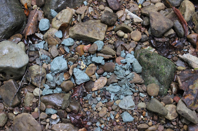
 Chunks of drying blue clay

Blue clay layers in the hillside

Closeup of beech drops.   They are parasitic on the roots of beech trees.

Pretty back in this holler

John along side Franks Flume for perspective.  
It is not a real high water feature, but it is pretty and unusual.
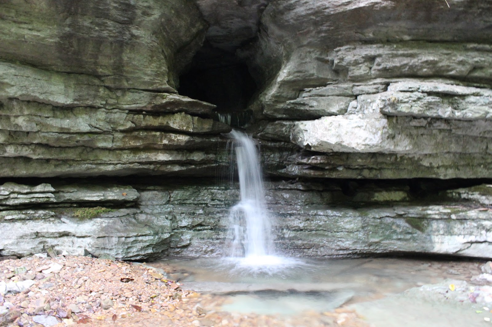
We hadn't gone too far on that rocky slick creek bed when someone sang out Here it is!

Franks Flume at last.   It is like a round keyhole in the bluff with water pouring out.
It runs all the time while the rest goes dry.  Minnows swam in the creeks back here!


  Sharon and I had to hoot and holler a big ole WOooooo Hooooo!  In jubilation and gratitude at having found it at last!  Like finding treasure! And getting new friends as part of that treasure!   Told you it was a good and unexpected day.   :-)  Ricky showed us another hole in the bluff that he says water shoots out of during times of high water.   It was dry today.  This feature flows constantly, but it varies with rainfall amounts.  There is an abandoned gas pipe that goes all the way back there and beyond!    

Below is a video of the flume that shows how neat it is compared to the photo.


  We went our ways, but met up again later.  A tree had fallen over the path on the way back!
In just that short time another one down!   We met Ricky, Cliff and Joshua again up top. We rode with them a bit more and they showed us yet another loop on the mountain.   I had that feeling
going through the depths of the next mountain holler through dark woods and pines..... I can't believe this is real.  Yet it is! It was a great day.

             We finally tore ourselves away. They had a gathering at Mr. Fleurs house (Flowers)
they invited us to. We declined for this time though it was mighty tempting.   We went back to the shabin and put stuff away.  Then we headed back to Maple Hill for a nice supper.
Today was a dream.  Sitting eating roast beef and taters and carrots outdoors on a cool evening.
A meadow of gorgeous late Summer wildflowers behind us.    Life is sweet and we are blessed indeed!

Tuesday, January 20, 2015

Lower Higgins Creek Falls Trip

See the Betty Butterfield Video HERE for 
the significance of a SKILLET* found out on the trail!  Mmmhellooo!

Lower Higgins Creek Falls Hike

Sunday Jan. 11, 2015
Dana & Kenny Koogler

Approx 3 mi. RT


   Kenny and I decided to visit some place we had not been for awhile.   I used to do all kinds
of hiking and bushwhacking and camping in the Northern Cherokee National Forest, but had really
slacked off in favor of other destinations.   We sat down together and perused my lists of possible trips.
Lower Higgins Creek Falls had been on our list for awhile and that is what we set out to do.

      We had to go through the usual logistical wrangling.  Being married to Kenny Koogler or 
best friends with Cathy Howell means one thing will always happen prior to trips.    We're going to
go over all possible route permutations.   Folks like them have one built in assumption for getting to a place.
"There HAS to be a better way!"  There has to be a shorter route, more direct route, one with less chance of
getting caught in traffic, etc.   So I have learned if I want to make my life a little simpler to do the math on the route options before starting out.   Dana just looks at the map and says "Eh, this will do." but I have  help satisfy the rest of the party that the best possible route has been chosen.    My tomtom navigation system and google maps had both said that going up I-81 and down I-26 through Johnson City to Erwin was the best way.   It was and so that is the route we chose.     

     It was cold and we had bundled up for the hike as it was cold, but clear.  The day warmed up to about 40 degrees.  We found the place with no problems.   We saw only one other vehicle at the trail head.
A deputy dropped on patrol and we spoke to him and began our hike.    It goes over a rotten looking 
bridge constructed of boards and maybe logs.   We followed the stream up.   It was not very hard, but the
trail was icy in places and rocky.   The stream was quite pretty and so were the woods. 

     About the time we arrived at the falls we saw our first fellow hikers of the day.
What a happy meeting that turned out to be.  We had been aware there were more falls along this stream and had the waypoints for the upper falls, but lacked any firsthand knowledge.  Our meeting of people included Martin Garrett and his pretty daughter.  He is as crazy about waterfalls as we are and is a wealth of knowledge about the area.  Both of them shared their knowledge freely. It was most fortunate. 
Instead of the plan we'd had to hike to Lower Higgins Creek Falls and go down to Rocky Fork... we spent 
our entire day here!  We made a new friend and hopefully it won't be the last time we are on the trail with him.   He gives accurate, easy to understand directions and the waypoints for the upper falls were 
no longer needed.

        Lower Higgins Creek Falls was partially frozen, flowing very well and beautiful!
It was one of those moments we wondered why we hadn't come here sooner?  

      Lower Higgins Creek Falls

      
Upper Higgins Creek Falls.. somewhat smaller but just as grand. 


      Today was practice day with my camera equipment.  Becoming so ill last December and spending three months recuperating played heck on many areas of my life.  Double vision was making my life rough just 
getting around and doing normal every day things.  I knew better than to tackle learning camera equipment during that time period.   Once I was well I found I still gravitated toward the easy way. Use the old, familiar Nikon or just use the new camera to point and shoot. I've been getting more serious about working on my waterfall photography skills and mastering the new camera.   I am still fighting with the ND filter as you can tell above.  Its improving though.

       We had to ford the stream twice to get to the Upper Falls.   Martin did a good job describing that as well.    The first crossing was easy and got me a standing ovation and applause from some lady hiking with Martin and his buddies!  Too funny.    The second crossing was icier and trickier, but Kenny helped me and 
it wasn't bad.  I can tell my balance and creek crossing skills are getting much mo' bettah.  My balance is
improved.    Higgins Creek has two other nice waterfalls between Lower Falls and Upper Falls, but there is no trail down to them.   We could glimpse them from the trail, but roped descents to them will have to be done on another trip.   We sat and ate our lunch at the upper falls.   

     We continued up a little further to satisfy our curiosity about what else might be up there?
We found a nice little slide and a small cascade in addition to the rest of the falls.  No trail to these either,
but you could tell other folks have walked down through the gentle slope to view them.  It was very easy.


       Top--upper cascade
Bottom--Slide below the upper cascade.

     We headed back down the trail.  We decided we'd see how we felt and what time it was as to 
what else we'd try to get into.   We had the GPS coordinates for the Rocky fork tract and thought maybe if
we were feeling froggy we'd hit up some of the roadside attractions.    
We had seen a side logging road taking off near a side stream on the way in.  Martin was over there exploring and shouted back that he had not been up there yet, but would get up there to look for falls at some point.    We later realized that was Burchfield Camp Branch and there is a waterfall up there, but it is small. It is on Tennessee landforms. Its about a 12 ft falls.    Further up the trail is part of the Rocky Fork Tract and the hidden lake. The name of it is Birchfield Lake I think.   It was a manmade lake used by the timber company who owned the land.  They built it as a reservoir of water to help fight forest fires.

       On the way back was when I saw it... the SKILLET hanging on a nail on the side of a tree.
We hiked the Rocky Bottom Gorge in NC for New Years many moons ago. There was a skillet hanging
in a tree that day too.  I launched into being Betty Butterfield with her whole whole lotta emotional problems most of which is existential.   The 49 second video on the link at the beginning of this blog entry 
tells about her being woke up hit in the back of the head by a 400 lb man with a skillet.  Her ex husband
is a double amputee Vietnam Veteran with PTSD and OCD.   She had to leave him because he was POW in his own mind!  My dark sense of humor flaring up again.

       We made it back to the jeep and it was 3:30 pm.   We are getting old and worn out.
We just wanted to go back to the house and flop down and be warm and together.  So that is what we did.
It doesn't take much to make me happy.  

Skillet on a tree. 

Wednesday, May 7, 2014

Tallassee Spring Wildflower Hike

Canada violet near the gate
Tallassee Wildflower Hike
Dana Koogler solo
Hike distance 3 miles approx.
**I lost most of my photos from this hike
when my computer crashed. I had just enough to post
a trip report using current images. I am including a link
to hikes and rides of the past. **
Pictures are here: Tallassee photos
   I enjoy hiking with people.  I also enjoy time to myself.  I find that time alone
 out in nature is vital to my health, sanity and creativity.   I like seeing new areas, but
there are times when a safe, familiar place of quiet is a real blessing.  I decided it was time
for a solo hike to an old familiar area of great beauty... down the road to Tallassee.
It is only about 25 miles from the house.  I loaded up the jeep with snacks and drinks.
Camera gear. Water shoes.  Hiking boots. Trekkers. And off I went!
Foothills Parkway was amazing today.  I had enjoyed the views but finally I just could not bear it any longer. I pulled over and took this photo.  Foothills Parkway West  rambles along the spine of Chilhowee Mountain from Walland down to Tallassee. It terminates at Chilhowee Lake.    It may some day run from Wears Valley to Tallassee. Work continues, but it has since
the 1960s!   Puts me in mind it is a government boondoggle.
           
    Hiking at Tallassee involves numerous crossings of Cochran's Creek.
It is what you start out with that the gate!! Back when we leased the land we could open the gate and drive through the creek avoiding the need for that first, deep, wet foot crossing.
Now there is no way to avoid it.  Thus the water shoes. I plowed through the stream up to my calves.  Only a short distance further and I knew I'd have to ford at least two or three more times. I chose to leave my water shoes on.
I tied my boot laces together and slung them over my shoulder and rambled on.
It was a decision I would come to regret. 
   I had not gone far until I came to another place I always turn aside and wade the creek and check out the flowers.  The stream is particularly pretty and wild. It winds like a ribbon through the trees.  It has always pleased me to stand up on the bank and see the curves of the stream through the forest as it carves out where it wants to go.  The stones in the stream
are colorful and just pleasing to my eyes in all that clear water!

  
     I had beautiful weather today. The skies were bluest blue and clear.  The sun shone kindly on me.  A light breeze fluttered the leaves.  The air smelled of flowers.  The stream flowed past babbling and sparkling.   I noticed the beavers had reconstructed their dam further upstream!
The flood waters had washed it out before so they had to re-engineer it!  
        I made my first turn at the big dogwood tree.  White dogwood blossoms shone in the sun.
I began to see some more wildflowers.  I stopped to photograph a pretty patch of blue phlox.
I was down on the ground when I heard a shuffling by me and felt movement.   It was a black
snake trying to get out of my way!  He went  his way and I took his photo. 

        My encounter with the snake did not stop me from wallowing in the experience today.
I was soon back laying on the ground in order to get pictures of Catesbys trilliums which are
hard to see. The blooms dangle below the leaves.  I am not above putting a twig against the stems to get them to cock back a little for me to have a better angle for a photo! 
I saw a few of them and some were crisp pure white and some were pink.


Two color variations of Catesby's Trillium.


   I continued ambling up the old rocky trail. The stream beside me was especially pretty.
It is a series of long, running cascades one after another.   I took pictures of one on
my way back.  I no longer have the photo, but here is a short video of it. It is so nice.  I had never climbed down
to this spot before. 


Pretty cascade at Tallassee.  I think this is a tributary stream of Cochran's Creek.


        I forded the stream again in a deep place at the crest of the hill.  I was pleased to see
that the huge downfallen tree was still there, but had mostly been removed!  I could at least ford without wiggling my way through its branches.   The crossing here is deep and slippery.
Adding the branches of a fallen tree did not do anything to make it simpler.  A short distance further I passed an old rock wall and the site of a structure.  I passed another series of scenic
cascades.  The ferns and moss and flowers here are so lush. 

      I continued on the sardine can cascade.   I noticed the dirt patch in front of the cascade
was a mat of soft, sandy earth.  Here on this spot of earth grew great numbers of pink and white spring beauties and purple violets.  A huge log had split open and filled with dirt.
It brimmed with white violets and green moss.   Life takes hold and flourishes in this place!

         I decided today the first place I'd go was the big open meadow.  I ambled along crossing
the creek a couple more times.   I soon found myself at the meadow.  It was great to see as it seemed a long time since I'd been there. 

Tall, tall trees!!  My camera only shows a portion of the grandeur of this wild meadow.
It was such a perfect day. The tall tree in the center and some of the others with palest green appeared silver in the light.  

    I grew up in a rural area of Virginia called Barren Ridge.    It is  a pine barren.  It is part of the Shenandoah Valley.  It  was wide open and quiet and pretty.  I always liked it there.  A common sight there was sage fields.   I come to Tallassee and hike and it is similar to Barren Ridge.  I feel right at home in a sage field with the birds singing.  I hiked all the way across the meadow.  I saw loads of purple birdsfoot violets and hot pink dianthus in the sage brush.
I re-entered the woods on the far side and hiked about 1/2 mile further.  I turned and headed back.   The walk back across the meadow provides a different perspective.

 I stopped and just drank it all in.   I love Spring here in this place.  There is something unmatched about the new pea greens of spring, silvery and shining against the deep, dark hunter greens of the pine trees that makes my spirits soar!   I could hear the bird songs. A hawk flew and circled in the skies above.  Far at the edge of the meadow I could hear the faint trickle of the creek.  I enjoyed a slow hike back in the direction I'd come from.   I stopped and closed my eyes.  I could hear no sounds of man.  Quiet except for the created works of God.  Nothing the hand of man could ever make could equal the splendor of the natural world.

       I realized two things.  I was growing tired.  My feet were wet and water logged. I was still in those water shoes.  I had lots of creek crossings and I was OK I told myself.   I wondered what in the world was wrong with me? I had hiked 11 miles one day. I hiked 13 miles another day.  I had only hiked a couple miles and I was weary?  Nothing for it.  Wherever you go.. you must get back.
I decided rather than push myself past the point I would be forgiving and head out.  I sat down and rested and ate a quick snack. It did nothing to relieve my fatigue so I continued heading back. I was torn since I had another leg of the Spring wildflower tour I wanted to finish. It would have to wait for another time. 
     Yellow trillium along my hike today. I  saw lots of these.
Sparkling Cochran's Creek at Tallassee on my hike today.  It is beautiful!
      I headed home and rested. I went to bed early and dreamed of this wild, wonderful place.
I dreamed of trips past climbing narrow knife edge ridges with Kenny through the pines.
Some of the previous trips we've taken here have been so exciting and pretty that I'd do them
all over again.   I am thankful for wild places and a husband who enjoys exploring them almost as much as I do! 

 I woke the next morning to sore, blistered feet. I should have taken the time and trouble to change to hiking boots! 

Monday, May 6, 2013

Tackett Creek

A very unusual candy striped Trillium!


Tackett Creek Ride

Dana & Kenny Koogler & friends
Total Ride Distance 45 miles

Saturday May 4, 2013

Pictures are here:
Tackett Creek Pix--starting with frame 32


   I had been wanting to get back up to Tackett Creek to ride again. We had been early last Spring. It was beautiful! I had seen all sorts of flowers in bud, but not blooming.  I just knew if we could get up there again in Spring I'd find all sorts of pretty things. I anticipated wildflowers and finding and photographing waterfalls!   We had talked to friends who declined going this weekend, but at the last minute changed their minds and said they'd go.  I had been on the fence about whether I wanted to hike or go riding?  I finally decided while Kenny was in the frame of mind to go we'd go ahead even if it was just the two of us.   I knew we'd be ok.

       I was going to write a trip report.. a real one about this day. I was glad to finally meet Jody.   I found that the day did not turn out as planned.  Another friend brought a different woman this time and she was not his original woman... who is our friend.  That set the tone for tension right shot out of the bag. I was uneasy all day and trying to make the best of it.  It did not help that the ideas of the ride leader and his motivations were widely different from mine.  I am about the experience and getting out to see what's around me and enjoy it. He wanted to cover a lot of ground.  It is not that one person is right and the other is wrong. It is just a difference in people. That's Life.   

     I found myself very sad at seeing many beautiful things but feeling I was not welcome or free to take my time and photograph things.  I did not want to make waves and cause problems, but I felt utter disappointment.   I was seeing marvelous wildflowers and only got to really photograph a fraction of what was there.   


     I have put the photos in a gallery.  I am just too sad over how this all went to write on it and I don't want to put something in writing that is going to be hurtful.
It will be the last time I do this kind of trip.  Kenny and I are like this. He prefers riding. I prefer hiking.  We compromise.  He doesn't mind me taking pictures and checking things out. He kinda likes that too and we work it out.  I didn't appreciate the tension. I did not appreciate the length of the ride which had me desperate for it to be over and feeling trapped.   Kenny and I go riding, but we stop and get off and hike some too!

   I will go riding again with my spouse and the few other friends we have who also like to get out and see things.  I won't go do this again with the limitations of this trip.  It was a learning experience.
  
   Sad. So sad.  

Sunday, September 23, 2012

Laurel-Snow Pocket Wilderness Hike

Blazing Star growing along the trail.

Laurel-Snow Pocket Wilderness Hike

Dana Koogler solo

Hike distance 5 mi. RT

(Out & back to Laurel Falls)

Pictures are here: 
http://tinyurl.com/955gpav

Videos are here: 

Lower Laurel Falls

Laurel Falls

Paine Creek Falls
(To see Paine Creek Falls see notes at bottom of page)

    I got up Thursday early and drove down to Dayton to hike. I'd been wanting
to hike Laurel-Snow Pocket Wilderness again.   Kenny and I hiked it about eight years earlier and it was real nice.  I don't recall everything about that trip, but I remember thinking I'd like to do it over when we'd had plenty of rain.   Today was my chance.  We got five inches of rain over the weekend with it finally drying up Wednesday.   I figured the crossing to Snow Falls would be a bust and it was.  The guide book warns that reaching Snow Falls at the far end of the hike is a wet foot crossing and that during times of heavy rain fall the creek is impassable.  Long way to hike only to have to turn around.    I contented myself with the idea of hiking the parts of the gorge that should be accessible this trip.  I was far from disappointed.

      The drive to Dayton is long at around 93 miles for me.   I got an early start, but after the drive I still did not get on the trail until 10 a.m.   Finding the wilderness itself was a challenge even with the tom tom to assist me.  I missed the turn, but realized it almost immediately and simply turned around.  I checked my directions and sure enough I was correct.  I need to update my tomtom as it seems to be on the fritz about half the time.    I had no recall of the road into the pocket wilderness.  I was not even sure I was at the right place.   It is worth mentioning that all the trash that had been in the woods at the parking area was now gone! That much I do remember.   I had called Bowater and the Tennessee Dept. of Natural Resources because folks were using the land as a dumping ground for old appliances,  household garbage, old furniture, you name it.   All of that is now cleaned up! The parking area is very tidy and improved.   

    I had not gone out of sight of the parking area when I heard a loud roaring to my right.  The creek to my left was raging, but even over that I could tell there was something off the trail to my right.  I recalled seeing that there was supposed to be a ten foot waterfall near the start of the trail.  I walked off the trail and went up the bank and followed the track others had trod.  Among room sized boulders, trees and logs was a beautiful waterfall about twenty-five feet  high. It was raging and from the point where I stood it flowed down the hill and formed a series of beautiful cascades.   The stream's flow split into about three parts among the rocks and gushed forth powerfully. 


Paine Creek Falls


    I continued on enjoying the view of the rushing stream to my left and the old stone structures from the mines to my right.  It was not long until I was flanked on the right by towering stone cliffs.  I passed the mine entrance and had to go in to see it.    It was dripping with water back there today.

Looking out of the mine.


One of many clusters of boulders and rapids along the stream.

      I saw only half dozen people on my hike in.  All of them were just day hiking.
I was surprised how quickly I arrived at the intersection where the trail continues straight up a short distance to the old Dayton Reservoir and the main trail veers sharply right and uphill.    I had visited the reservoir the last time so today I opted to stay on the main trail.
I saw a few blown down trees that were nearly all cleaned up and moved.  The trail was high above the stream now and provided good views of the bluffs on the far side of the gorge.  I got a good look at Buzzard Point complete with soaring, gliding buzzards!
I'll hike there next trip.

Buzzard Point viewed from the main trail.

  The trail up high continued for a short spell and soon I was rounding the bend where the forest changed character.   The air was cooler and the trail dropped to a lower level. The forest here was a healthy hemlock gorge.  I arrived at the first metal bridge over a stream.
All around me was verdant, lush and green with rushing white ribbons of water passing beneath the bridge.   Ahead on Laurel Creek I could see one cascade after another.
Just across the bridge the trail splits and goes right for Laurel Falls and left for Snow Falls.
I headed right and soon came to this spot where I had lunch. 

Lunch spot by some massive boulders and a lovely cascade on Laurel Creek.

    I followed the trail only a short distance until I arrived at Lower Laurel Falls.
It is a very pretty ten foot tall cascade on Laurel Creek.   The trail then continues
uphill.   I had to crawl through a hole in some boulders to keep going. That is how the trail is routed here. Makes it interesting.


Lower Laurel Falls

     I followed the trail uphill on some easy switchbacks.  I did not recall going this way before, but the blazes were consistent and I had no trouble finding my way.   I noticed lots of colorful Autumn wildflowers along the path.  Red hearts-a-bursting. Pale purple & white asters.  Golden asters. Goldenrod.  Pink Blazing stars.  I saw lots of bees, butterflies, and dragonflies today as well.   The stream was to my right now and filled with numerous cascades and small falls.  The terrain was treacherous and I was alone so I did not explore the gorge the way I would had I been with Kenny.   Instead I continued until
I glimpsed the top of eighty foot high Laurel Falls. I could hear it well before I could see it.
It was a raging cataract today and extremely impressive!   The spray from the falls had everything slick so I had to use caution getting close to the base.  I finally ended up
coming around to the far side of the falls to get the best photos and video footage without being drenched in mist.   The sun shining down through the spray was so pretty.  The wind was gusting. Above me against the high cliffs was another wet weather falls that was about sixty feet high.    I sat and soaked in the beauty and glory of this place today.
I was glad I had the chance to see it and I hope to be able to bring Kenny back to enjoy it.
When we were here before one thing I do recall is that it was nowhere near this much water coming over the falls.


Laurel Falls from the side.


    I can hardly wait to come back here to do some more exploring.
I eased on back toward the trail head. I encountered more people on my way out.
Most of them were kayakers!  It occurred to me that I wondered if anyone ever died kayaking Morgan Creek?   American Whitewater's statistics say no, but there have been numerous close calls.   Morgan Creek is one of the steepest streams in the area and descends the entire plateau in minutes.  Much of it is what they deem un-runnable and mandatory portages.  When extreme creek kayakers say something is un-runnable it gets my attention.   The North Pole run begins on the other side of the gorge at Snow Falls and continues down. I don't know what they consider the takeout point.

     I had a hankering to visit a fire tower today and managed to find one nearby.
I visited the attractive Summer City Fire Tower and what a day for views!


Summer City Fire Tower is accessible to the public, but the cab is locked.

View from the Summer City Fire Tower

Here is a link to a few photos from Summer City and other fire towers.
http://tinyurl.com/d6ydkoo

    I have a link posted up top to several really good videos of waterfalls from the day's outing.  I ended my day by hunting for Morphy Falls.  It was supposed to be in the area nearby.  I did find it, but was dismayed to find it was on private property.  I had pulled down into a lane and was hunting for a wide enough place to turn around safely.  I looked up and there it was right before me at the end of the road.  I figured no harm in snapping a few photos and a short video clip.  It was not a super great waterfall, but I was pleased to get to see it.   

     It was a fun day and I was tickled at having seen so many pretty and new sights.
I was also happy to get to practice using the GPS to successfully locate neat things!

**Paine Creek Falls and other beautiful waterfalls are on a side canyon where Paine Creek enters the Laurel Falls gorge from the right heading in.  You will have barely left the parking area before you encounter a side stream on the right. That is it.  There is no official trail to visit these falls, but it is possible to bushwhack/ creek crawl up there to see a series of falls. **

Tuesday, July 3, 2012

Woo Hoo Holler Weekend 2012


   Fireworks in Woo Hoo for the 4th of July.

Woo Hoo Holler Weekend

Dana & Kenny Koogler
Sharon, John, Brenda, Brett, Tabitha
Friday June 29 -Monday July 2, 2012

Pictures are here:

http://tinyurl.com/6qpujlv

Video below:
Snake Handlin' in Woo Hoo Holler


     We had planned for months to get together with our friends in Fentress County, TN for July 4th weekend.  Sharon and John's place she dubbed Woo Hoo Holler.  It is very fitting and such a beautiful place.  The best part though is the company with the scenery and remoteness of the place being a close second.  Sometimes a portion of my life is too personal, too important to write about.  This is one of those times.  I think its a combination of things mattering too much to me and being too intimate and intangible for me to adequately express. There are  no words to capture every thing I felt and did or that took place.   I'll post a few of the photos and let that be enough. 

     Suffice it to say that this was a weekend that will live in my heart and mind forever.
I still miss Ed Choate as we all do. No one more than Brenda.  I can still see his smile and hear his laugh.   I know that as much as we miss him he still loves us. We'll see him again in Heaven. For all the fun we are having he is having more fun in Heaven with all those who have gone before in the presence of our Lord.  He was a catalyst for bringing us all together.   I decided a long time ago I was not asking my Father God for enough of his blessings in my life and that I needed to ask for A LOT.  He answered by sending these friends into my life and the life of my family.  The windows of the Blessing Store House burst open wide! . The scripture below tells what happens when you ask for plenty of it!
Thank you Heavenly Father for your blessings & goodness in my life!

Give, and it will be given to you; good measure, pressed down, shaken together, running over, they will pour into your lap . . .  – Luke 6:38


Rainbow Cave in Overton County, TN  Kenny and I visited here and the cave is pretty, but dry. No waterfall today. We are planning to come back during a time of heavy rain and see this and some other caves and falls in the area.


Green Pond Arch with Kenny looking out.


Lower entrance to Xanadu Cave. We crawled back in there so far we could see only darkness!


Tiger Lily with butterflies.

Dana & Sharon swimming in Caribbean Blue Water.Can't touch bottom. Have to jump in off the bank. Spring fed water hole. Cold! 65 degrees!


Another great swimming hole with two rope swings! We wore them out!


Kenny made this rig so we could take one vehicle and all the toys! He did a beautiful job! Thanks to Neil for helping him!