Showing posts with label fire towers. Show all posts

Monday, June 22, 2015

CMC Lookout Tower Challenge --Its Next!

Cowee Bald Tower 

CMC Lookout Tower Challenge --Its Next! 


Decided June 22, 2015


 Below I am listing which ones I still need to complete by region.


Northwestern North Carolina

Flat Top Mountain

Rendezvous Mountain

Moores Knob 10/31/01

Blue Ridge & Black Mountains
Bearwallow Mountain

Little Snowball 

Mt. Mitchell
Done 7/4/2015

Green Knob
Done 7/5/2015

Central NC Highlands

Chambers Mountain

Camp Creek Bald 

Rich Mountain

Great Smoky Mountains & Vicinity

Mt. Noble

Nanatahala National Forest

Yellow Mountain completed 4/15/2022 3 mi RT via Cloud Catcher Lane

Albert Mountain 

Panther Top

Hiked 10/17/15

Joanna Bald
Hiked 8/2/15

Wesser Bald


Saturday, August 9, 2014

Cumberland Plateau Exploring--Foster Falls & Coppinger Cove

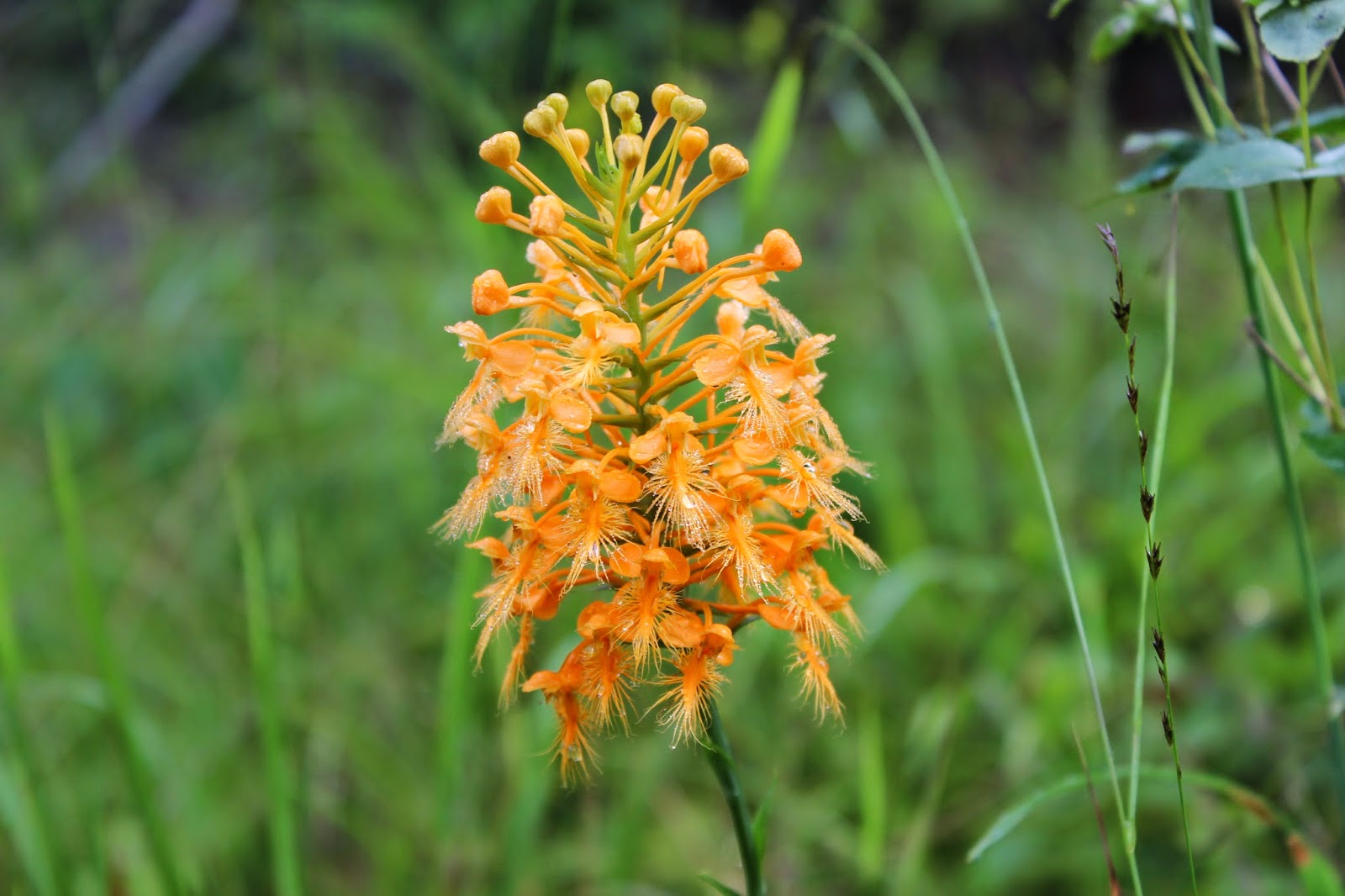
Yellow Fringed Orchid Season is here!

Hiking and Exploring Foster Falls, Coppinger Cove & 
Sequatchie Cave State Natural Area

Dana  & Kenny Koogler
Sunday August 3, 2014

Foster Falls Photos


   We stayed in the Super 8 Motel at Monteagle Saturday night. It was a good value.  It was decorated modern and clean as a pin.  I would stay there again based on the price, value and convenience. One thing I did not like was if you don't pay with a credit card they charge a $100 deposit.  For a single night stay we paid cash. I didn't feel good about that policy and I would prefer staying down in Jasper at the Comfort Inn next time. Note to self!  We slept well and 
got up the next morning and packed up to go get breakfast. We were both still so stove up  
from all that bone jarring ride toward the last of Saturday we were not interested in going riding today.   We opted to get some exercise in by hiking. 

        We didn't want to get into a lot today as we had a three hour drive home. 
Foster Falls was nearby and we thought we'd go there and hike a bit. We had camped there once and wanted to see if the rumors they had  updated the campground for RV camping were true?  
We went and found the place and it was still set up for tent camping only.   AsFar as I know
 there is no RV camping close to that area.  I read that Laurel Trails Campground closed up.   
We hiked the trail to Foster Falls first.

       We stopped by the overlook.  We checked that out and it was very pretty. It was a nice clear day and the view was good.   We headed down into the gorge to visit Foster Falls from the base.   The hike down is not long, but it is very scenic. It is a dark green hemlock forest in a gorge.   I recall the first time I saw it
in March  2002.   It was on a camping trip.   We stayed Friday and Saturday night.    We went climbing.
We got up early in the morning and hiked down to the waterfall on Saturday.  It was so pretty it inspired a
little impromptu romance in the woods hidden behind a huge boulder. We thought we were out of view.
What do you do when you are bathing in the afterglow of love and you hear applause from way up there somewhere......... on the cliffs?  Take a bow? Crawl in a hole?    We were heading across the suspension
bridge when Kenny got to retelling the story and I had to laugh.   Oh well... wouldn't life be boring as heck
if things always went according to plan?  Life needs spicy moments.  The older I get the more I am convinced of that.    The other take away ? NEVER trust rock climbers.  Sneaky little devils.

       
Suspension Bridge across the gorge heading to Foster Falls

Foster Falls from the base. It is about sixty feet high. 


    We soon arrived at the base of Foster Falls. It was as pretty as I remembered.  It sometimes dries up in Summer like many other falls in the Cumberland Plateau, but this one is the highest volume waterfall year round of all others.   We spent some time here just enjoying the view. I took time to work on learning to use my new camera and lenses better.  Kenny helped me some.   It is a work in progress.

        We hiked back out and were surprised it was not that bad.   Kenny had agreed to hike the power line cut with me. I wanted to botanize some today.   Our efforts were rewarded handsomely.  We found lots of orchids and other pretty flowers in the area.    Always remember that orchids like power line clearings! 
 Platanthera ciliaris-- Yellow Fringed Orchid.  
Above: 
 View from the overlook trail. 


Hypericum gentianoides (Orange grass) with the tiny yellow flowers.  Polygala curtissii --Curtiss' Milkwort with the pink drum shaped flowers.  If you get the chance to find orange grass.. crush some and inhale its fragrance. It does smell delightfully like a fresh orange!  Other wildflowers seen today were:
lots of blazing star, fame flower, Joe Pye weed, Maryland meadow beauty, blooming shrubs were sumac.. which smelled like the breath of Heaven. Unbelievably birds foot violet was still in bloom and it is August!
Saw gopher weed, but was not in bloom.  


 Below: 

We hiked part of the Fiery Gizzard Trail. It was pretty too.   


Top: Fiery Gizzard Bridge and Bottom: Gizzard Creek


     We wrapped up our hike at Foster Falls and decided to go hunt up a local fire tower.
The upper end of the road was unsigned so we missed the turn.  We soon found it though.
It was not the most interesting fire tower I've visited, but it was neat.  It is the Big Hill Lookout Tower in Jasper, TN.   It is in good repair.  I climbed it as far as I could, but the cab was locked. The steps had been restored, but it appeared the cab was original. The view from up there was still pretty even having to peer through the legs of the tower. 


Big Hill Fire Tower in Jasper, TN near Foster Falls.


View from up in the Big Hill Tower.  

    The drive out Fire Tower Road to visit the tower was pretty.  I saw lots of yellow fringed orchids just standing along the road!  Kenny was kind enough to stop and let me check them out.  We try to compromise on things. I put up with his rocky, rough ass trails and he puts up with my wildflower ramblings.  Together we are a great team!  One thing we talk about from time to time is my propensity for what appear to be trivial "useless" tidbits of information.  Our mutual love of exploring and outdoors is one of our greatest bonds.  Part of what makes that possible is my insatiable curiosity and my R2A2 for details that help bring us closer to finding things.
What is R2A2? It is W. Clement Stone's formula for success.
Recognize, Relate, Assimilate, Apply (Action!) 
I used to work for W. Clement Stone's Combined Insurance Company.  It means that I did a lot 
of reading about goal setting, positive mental attitude, and learned about the 
reticular activating system of the brain.  It can be taught to function like one of those computer programs running in the background that snaps to high attention when something is pertinent to achieving a goal.  It recognizes "Thats for me".  about words, things on maps, people, that move me closer to finding things I want to find.  It is something Kenny has learned to put up with in me and just go with it. He has been on the other end of it where it pays off and we find things that seem to come out of nowhere.  They do come from somewhere.  They come from constant searching and scanning. I'm like a waterfall seeking, cave seeking, trail seeking, adventure seeking Fem Bot! 


Roadside lined with lots of yellow fringed orchids and a close up of one.

    Kenny is a good thing finder too. He realized just based on a wrong turn we'd made that we were very close to Coppinger Cove already!  We had wanted to head down into that area to see what we might run across for future trips.   It is the lower end of where we'd ridden on Saturday. We found what we were looking for with no trouble.  It is beautiful down in there!  


Twin Chimneys at the end of Coppinger Cove Road. The trail takes off right past this.


The trail crossing the river.   This is one of those moments when I'm looking into my 
Crystal Ball of the Future and I see all sorts of good times and fun adventures! 


The Little Sequatchie River . A stump in the foreground with steps nailed to it. 


A suspension bridge over the Little Sequatchie River at Camp Glancy. 

    The area down in that cove along the Little Sequatchie is a slice of Heaven on Earth.

We had seen a sign along the main road for Sequatchie Cave State Natural Area. I had not even heard of this.  We went back there to check it out before heading home.   It was lovely and we took a look at the spring and the cave before using this pretty spot to eat lunch and then start home.  


Blowing Spring-- a cave with a huge spring coming out. It is so large and cold it 
forms Owen Spring Branch.


Owen Spring. The water is so cold. I'm guessing 58 degrees. It feels like when you ford a stream 
in the Smokies in Winter.  Little hammers hitting your feet until they throb!
It is a day in August where it is sunny and 87 degrees! 

    We will be back here to have more adventures and do more exploring.  We have only scratched the surface.    What a fun trip. We headed out to face the long drive home. We will either try to get back over here to stay at Hales Bar Marina Campground next time or possible our favorite.. Raccoon Mountain Campground!  Good times to come!

Sunday, September 23, 2012

Laurel-Snow Pocket Wilderness Hike

Blazing Star growing along the trail.

Laurel-Snow Pocket Wilderness Hike

Dana Koogler solo

Hike distance 5 mi. RT

(Out & back to Laurel Falls)

Pictures are here: 
http://tinyurl.com/955gpav

Videos are here: 

Lower Laurel Falls

Laurel Falls

Paine Creek Falls
(To see Paine Creek Falls see notes at bottom of page)

    I got up Thursday early and drove down to Dayton to hike. I'd been wanting
to hike Laurel-Snow Pocket Wilderness again.   Kenny and I hiked it about eight years earlier and it was real nice.  I don't recall everything about that trip, but I remember thinking I'd like to do it over when we'd had plenty of rain.   Today was my chance.  We got five inches of rain over the weekend with it finally drying up Wednesday.   I figured the crossing to Snow Falls would be a bust and it was.  The guide book warns that reaching Snow Falls at the far end of the hike is a wet foot crossing and that during times of heavy rain fall the creek is impassable.  Long way to hike only to have to turn around.    I contented myself with the idea of hiking the parts of the gorge that should be accessible this trip.  I was far from disappointed.

      The drive to Dayton is long at around 93 miles for me.   I got an early start, but after the drive I still did not get on the trail until 10 a.m.   Finding the wilderness itself was a challenge even with the tom tom to assist me.  I missed the turn, but realized it almost immediately and simply turned around.  I checked my directions and sure enough I was correct.  I need to update my tomtom as it seems to be on the fritz about half the time.    I had no recall of the road into the pocket wilderness.  I was not even sure I was at the right place.   It is worth mentioning that all the trash that had been in the woods at the parking area was now gone! That much I do remember.   I had called Bowater and the Tennessee Dept. of Natural Resources because folks were using the land as a dumping ground for old appliances,  household garbage, old furniture, you name it.   All of that is now cleaned up! The parking area is very tidy and improved.   

    I had not gone out of sight of the parking area when I heard a loud roaring to my right.  The creek to my left was raging, but even over that I could tell there was something off the trail to my right.  I recalled seeing that there was supposed to be a ten foot waterfall near the start of the trail.  I walked off the trail and went up the bank and followed the track others had trod.  Among room sized boulders, trees and logs was a beautiful waterfall about twenty-five feet  high. It was raging and from the point where I stood it flowed down the hill and formed a series of beautiful cascades.   The stream's flow split into about three parts among the rocks and gushed forth powerfully. 


Paine Creek Falls


    I continued on enjoying the view of the rushing stream to my left and the old stone structures from the mines to my right.  It was not long until I was flanked on the right by towering stone cliffs.  I passed the mine entrance and had to go in to see it.    It was dripping with water back there today.

Looking out of the mine.


One of many clusters of boulders and rapids along the stream.

      I saw only half dozen people on my hike in.  All of them were just day hiking.
I was surprised how quickly I arrived at the intersection where the trail continues straight up a short distance to the old Dayton Reservoir and the main trail veers sharply right and uphill.    I had visited the reservoir the last time so today I opted to stay on the main trail.
I saw a few blown down trees that were nearly all cleaned up and moved.  The trail was high above the stream now and provided good views of the bluffs on the far side of the gorge.  I got a good look at Buzzard Point complete with soaring, gliding buzzards!
I'll hike there next trip.

Buzzard Point viewed from the main trail.

  The trail up high continued for a short spell and soon I was rounding the bend where the forest changed character.   The air was cooler and the trail dropped to a lower level. The forest here was a healthy hemlock gorge.  I arrived at the first metal bridge over a stream.
All around me was verdant, lush and green with rushing white ribbons of water passing beneath the bridge.   Ahead on Laurel Creek I could see one cascade after another.
Just across the bridge the trail splits and goes right for Laurel Falls and left for Snow Falls.
I headed right and soon came to this spot where I had lunch. 

Lunch spot by some massive boulders and a lovely cascade on Laurel Creek.

    I followed the trail only a short distance until I arrived at Lower Laurel Falls.
It is a very pretty ten foot tall cascade on Laurel Creek.   The trail then continues
uphill.   I had to crawl through a hole in some boulders to keep going. That is how the trail is routed here. Makes it interesting.


Lower Laurel Falls

     I followed the trail uphill on some easy switchbacks.  I did not recall going this way before, but the blazes were consistent and I had no trouble finding my way.   I noticed lots of colorful Autumn wildflowers along the path.  Red hearts-a-bursting. Pale purple & white asters.  Golden asters. Goldenrod.  Pink Blazing stars.  I saw lots of bees, butterflies, and dragonflies today as well.   The stream was to my right now and filled with numerous cascades and small falls.  The terrain was treacherous and I was alone so I did not explore the gorge the way I would had I been with Kenny.   Instead I continued until
I glimpsed the top of eighty foot high Laurel Falls. I could hear it well before I could see it.
It was a raging cataract today and extremely impressive!   The spray from the falls had everything slick so I had to use caution getting close to the base.  I finally ended up
coming around to the far side of the falls to get the best photos and video footage without being drenched in mist.   The sun shining down through the spray was so pretty.  The wind was gusting. Above me against the high cliffs was another wet weather falls that was about sixty feet high.    I sat and soaked in the beauty and glory of this place today.
I was glad I had the chance to see it and I hope to be able to bring Kenny back to enjoy it.
When we were here before one thing I do recall is that it was nowhere near this much water coming over the falls.


Laurel Falls from the side.


    I can hardly wait to come back here to do some more exploring.
I eased on back toward the trail head. I encountered more people on my way out.
Most of them were kayakers!  It occurred to me that I wondered if anyone ever died kayaking Morgan Creek?   American Whitewater's statistics say no, but there have been numerous close calls.   Morgan Creek is one of the steepest streams in the area and descends the entire plateau in minutes.  Much of it is what they deem un-runnable and mandatory portages.  When extreme creek kayakers say something is un-runnable it gets my attention.   The North Pole run begins on the other side of the gorge at Snow Falls and continues down. I don't know what they consider the takeout point.

     I had a hankering to visit a fire tower today and managed to find one nearby.
I visited the attractive Summer City Fire Tower and what a day for views!


Summer City Fire Tower is accessible to the public, but the cab is locked.

View from the Summer City Fire Tower

Here is a link to a few photos from Summer City and other fire towers.
http://tinyurl.com/d6ydkoo

    I have a link posted up top to several really good videos of waterfalls from the day's outing.  I ended my day by hunting for Morphy Falls.  It was supposed to be in the area nearby.  I did find it, but was dismayed to find it was on private property.  I had pulled down into a lane and was hunting for a wide enough place to turn around safely.  I looked up and there it was right before me at the end of the road.  I figured no harm in snapping a few photos and a short video clip.  It was not a super great waterfall, but I was pleased to get to see it.   

     It was a fun day and I was tickled at having seen so many pretty and new sights.
I was also happy to get to practice using the GPS to successfully locate neat things!

**Paine Creek Falls and other beautiful waterfalls are on a side canyon where Paine Creek enters the Laurel Falls gorge from the right heading in.  You will have barely left the parking area before you encounter a side stream on the right. That is it.  There is no official trail to visit these falls, but it is possible to bushwhack/ creek crawl up there to see a series of falls. **

Tuesday, September 11, 2012

Barnett Knob Fire Tower Hike


Barnett Knob Fire Tower Hike

Dana Koogler solo

Monday Sept. 10, 2012

Pictures are here starting with frame 37
Barnett Knob Pix


   I  was in serious need of some time outdoors so I planned on Monday to get out and hike to see the Barnett Knob Fire Tower.  I 
also planned to enjoy the views and Fall wildflowers and lunch at Balsam Mountain Picnic area.  I would then head back to Smokemont
and hike to Chasteen Creek Cascade.  A good days outing, but nothing
too extreme.   

     The day was gorgeously clear with temperatures in the sixties in the higher elevations.   I was blessed with sunshine, fresh air, and grand stand views.    Traffic was not too bad on a random Monday.

      I quickly found the turn off road for Barnett Fire Tower.
I parked and grabbed my gear and headed up there.  It was an easy hike and simple to find.    The fire tower was still standing including the old watchman's cabin.    I went inside the cabin and prowled around.  The tower was manned and used until 2004 according to Peter Barr's book.    It was the most modern watchman's cabin I'd ever seen.   Cowee Bald Tower is also very modern, but this one during the time it was used would have been the one to get my vote for "Most Comforts of Home".   Watchman's Cabin at Barnett Knob Tower

Watchman's Cabin at Barnett Knob--I found it still standing & unlocked.


Barnett Knob Tower


   I climbed up in the tower itself and enjoyed the views.  I'd picked the perfect day for this sort of trip.  It was very clear and the air smelled great.  It was cooling off and I could sense the gradual approach of Fall.    I could see the Smoky Mountains, the Plott Balsams, Mt. Noble and its tower in the distance.   I could see the privy down below. I had not been able to see it until I climbed up. 
  

My favorite view from Barnett Knob Tower taken from between the legs. I found the cab pad locked.  Looks as though it is still being used to gather weather info.


     I found a heater on in the cabin and it was cherry red hot.    It was in the ceiling of the bathroom.   I found a switch and tried to turn it off. Eventually it did go cold, but I
could not tell if the switch turned it off or if it was set to cycle?  I wrote to Peter Barr about it to see if he had any answers.  Hot as it was I'd feared it would burn down the hut!  I am waiting to see if I hear from him.

      I hiked back down to the jeep and proceeded out to Balsam Mountain.
The drive along the parkway was great.   My thermometer registered 59 degrees by the time I stopped for lunch.  I enjoyed the goldenrod, gentian, asters and other flowers along the way.  I began to feel poorly so I stopped to eat and rest.   I've been struggling with an illness that has made its way through my family for a month now.   I'd wakened feeling pretty good and believed I might finally be over it.   Now the fever, chills, body aches and cough returned full force.   Ever the stubborn mule that I am.. I was not going to be so easily outdone.  I popped a couple tylenol tabs, ate lunch, took some deep breaths, and rested.   I figured "Shoot! I'll get this temperature and chills beat back and ride on out to Smokemont. I'll certainly feel like hiking once I get there."  That is what I told myself.

      I headed to Smokemont and continued to tell myself I was fine.
I got out my hiking guide for a quick glance at the directions to Chasteen Creek Cascade.
I'd hiked to this falls before and found it very easy.    I sat there looking at the directions and the reality of my situation confronted me.  I was SICK.  Really sick. It was not going away. I was getting worse.    It was going to take everything I had to drive home. No one was there to call to come meet me.  I had to fix this myself.   I backed out of there and began heading home.  The drive seemed like it took forever because of the misery I was in.    I finally made it and boy was I pleased to be home.

       I started some antibiotics right away and went back and forth from the bed to the couch.    My day didn't go as planned, but I got out for a little bit.   I'm feeling better today.   The chills, fever, body aches and cough are gone.   Thank the Lord for that!

Mile  High Overlook Balsam Mtn Road  GSMNP NC  6/17/07
View from Mile High Overlook

Below is a short video of climbing the fire tower.