We got back to the vehicle on Saturday evening to find that all was OK.
We'd not had anything vandalized. A great relief. We knew from the forecast that
Sunday morning was supposed to be pretty, but very cold. The weather man got the forecast
correct and we woke to fifteen degrees with a high expected of thirty-five!
We planned to sleep in, eat breakfast, and ride up on the mountain behind the motel where
there was supposed to be a really big waterfall. We figured if we found that one
we'd then just head home.
We bundled up and went in search of it after breakfast. We found a spring coming out
of the mountain, but it was bleak looking and there was rock mining going on. We just weren't feeling it was right to be up there prowling around especially as cold as it was. Kenny said he
felt we should get going and so we did. We always try to have a back up plan. I had a clear
idea of where we needed to be today. I'd had something pulling me in a given direction.
Not to a waterfall, but to a sink hole! I thought the test would be to tell Kenny my plan and
if he agreed we'd go. He has learned to trust that little vibe I get as I trust his. He instantly said Yes! Let's go. I like that idea. I knew this was going to be good.
I usually tell where we go. Today as I write this blog I will NOT be revealing the location.
Do not ask me for any names or directions. I posted the photo on Waterfalls of Tennessee
facebook group and got all sorts of questions and friend requests. It is not that people like me so
much as they want to pump me for info.
I have certain trusted persons I share and swap info with. I may not have met a person
in real life, but if I know them by regular contact in the internet and know them by reputation..
I may learn to trust them and share with them. We learn to trust one another with secrets.
I will no longer respond to every request for info from rude persons who think its OK to simply
type under a photo "Where is this?" and share my hard earned knowledge.
One jackass who saw that I was not willing to share the info on FB about the location launched into assault mode. Told me how 'arrogant I was and wanted to know if I thought I was the first person to ever visit those waterfalls." My answer was simple. No. I know some of the people who have been. They did not tell me how to get there. I found it myself. That man did not even know me. He does not know my heart. He does not care about my hard work, what drives me, what leads me. He does not know or care how many people I've helped to find pretty places.
I have learned my lesson about casting pearls before swine.
Give not that which is holy unto the dogs, neither cast ye your pearls before swine, lest they trample them under their feet, and turn again and rend you.--Matthew 7:6
Waterfall #1 in the sink hole a nice 40 footer
Waterfall #2 in the sink hole. approx. 20 ft.
Plunge pool at base of 1st falls.
Both falls together.
Cliffs of the sink hole that is Kenny climbing up there for scale.
Winter sun warming things up down in the bottom of the hole.
We had a grand adventure and what started off as a bitterly cold day turned out
to be the most fun ever! The sun was shining. We bundled up like polar bears.
The day warmed up to where with all our coats and scarves and gloves we were comfortable.
Lula Belle is the name Kenny has given the RZR :-) Coppinger Cove to Bryants Cove Four-Wheeling Adventure
Kenny & Dana Koogler
Sat. Feb. 14, 2015 Total ride miles = 30 Coppinger Cove to Bryants Cove Photos are here and are a combo of three different days events--same trip. Coppinger Cove Pix
We got up and ate a quick breakfast at McDonald's before we hit the trail. I am thankful
that McDonald's has healthier choices for breakfast now. I dearly love their fruit and maple oatmeal and it stays with me a long time without dropping my blood sugar later. We were very excited to get going. We bundled up since it was twenty-two degrees this morning, but it was supposed to warm up to fifty-five degrees through the day. We dressed in layers we could shed
as the day progressed. We had ridden down to the jumping off point and checked the water levels
Friday evening. Looked like it was going to be fine. We had figured where to park in advance.
We ended up parking along the highway in a wide spot on the shoulder. It seemed
like a place no one would mess with anything. We just putted along down the road a couple miles
until we hit the trail. We crossed that first ford without a hitch. It was fun and once we got crossing you could see the rocks on the bottom all the way. No worries. We were both
really excited about today's adventure and hoped we'd find all sorts of pretty spots. We
also thought we'd try to located Abraham Falls today from the bottom of the gorge and go
up toward it.
Deep green shimmering Little Sequatchie River in the Winter sun.
We were treated to riding along on mud, rocks, and through lots of water.
We passed some old home sites, cairns, chimneys, chimney piles, and one really odd
old foundation of something. I don't know if it was the people's cellar or their house? See the photo below and you decide.
Kenny by the river at a camp site.
We came to an sign on a tree that indicated "Higgins Cemetery" so we turned aside to see it.
We passed an old home site with a massive chimney, and the biggest stone walls we'd ever seen outside
the Smokies. They built some pretty serious enclosures for something. Cattle or to protect vegetable gardens against browsing stock or deer. The cemetery is obviously being well tended
by the descendants.
Higgins Cemetery. Most of the graves date 1800s.
We continued up the trail and were following the GPS waypoint toward Abraham Falls.
We realized we might not be able to reach it, but it was fun to try and to dream.
No photo of it on Tennessee land forms so no way to tell if it was even worth visiting.
We forded the Little Sequatchie at a very wide ford and this is the view looking up the river.
Sitting in the middle of the Little Sequatchie looking at a distant pinnacle.
Here is a view of a particularly pretty stretch of trail along the river. The day was warming up.
We realized we were following a track that lead us up Pocket Creek which was part of what we'd need to do in order to locate Abraham Falls. We held out hope and tried numerous side trails to the right heading east in order to find it. Each one we tried eventually played out.
At some point we finally arrived at the side drainage or gulf we'd need to enter to head up to it.
It was a mile or so away without any semblance of a trail for either RZR or any foot trail or man-way heading in that direction. We opted to abandon the search for Abraham Falls for today.
**Note to self: Try reaching Abraham Falls from above along Mt. Olive and Rankin Roads and a shorter bushwhack. If it is located and IS a worthy waterfall of some size with a healthy flow it
would be worth the bushwhack from the bottom to reach the base. **
We did go quite a long ways up Pocket Creek and two things happened.. no three!.. no four!
1. We realized we had connected the trip from Summer coming in from Bryants Cove with today's ride! That felt mighty good to put it all together and have it start to make sense. 2. We got within a mile of the base of Mike's Branch Falls where we'd been yesterday. Consequently if we ever decide to bushwhack to the base of the falls this way might be better than coming in from the chimneys as it is an actual trail. Too grown over for the RZR and too small, but a trail!
3. Kenny realized we could probably take the trail we were on and turn left and keep going coming out in The Pocket up top at some of the views we enjoyed out the trail the previous day. 4. We got to explore Pocket Creek and see some of the hidden gems along it.
We were riding along and I saw the terrain make a deep cut back toward the trail. A
hole of sorts deep and dark and that little cry from my soul to STOP! There is something here
worth seeing. We bushwhacked down to the stream and found a glimmering, aquamarine stream
with a series of beautiful rapids, chutes, tranquil pools and boulders that were deep and dark and
massive. The bank here was scooped out and had a pretty little sandy beach with mossy stones that made a good place to stand safely and enjoy the scenery. We climbed all around the boulders
and stood on stones in the middle of the stream. A little Shangri' La in the middle of Marion County, Tennessee. We were both beaming with happiness. I live for moments like this.
Spending time with my sweetie and seeing the beauty of God's created works.
My favorite view of the day along Pocket Creek. Thank you Lord!
Below is a video of Pocket Creek
We also came to the waterfall along the trail we'd been past during Summer.
It was dried up then. Pocket Creek had almost no water in it during August. Today it was rushing healthy. We approached this flat area on our left and I saw rock and insisted we turn aside to see it.
We crested the flat spot and this is what we saw!
A waterfall emerging from the sides of a cave and dropping into a cave. Ice. Snow. Waterfalls, rainbows.
We spent some time here enjoying this very cool cave and waterfall with its shining rainbow!
It is about 30 ft high and drops into a large sink or cave and the flow of the water disappears from sight.
It is NOT part of the flow of Pocket Creek, but is near it.
Below is a video of Rainbow Falls
We continued up the trail a short distance. I got out and walked took pictures and Kenny zipped around in the RZR and played. Pocket Creek was flowing down toward us.. and formed a pretty, stream wide cascade. Low, but wide and scenic. Beyond that and just prior to the cave waterfall the entire stream disappears into a swallet. It never resurfaces again to my knowledge.
Pocket Creek Cascade-- lots more water than in Summer.
Pocket Creek disappearing down the bath tub drain.... a large square entranced swallet. Interestingly..
the trail used to cross right above this , but the rock was undercut so much by the force of the stream the rocks and soil gave way and the whole section of trail collapsed and had to be re-routed. I'd hate like hell
to have been going over that muther when it gave way! You'd have gotten washed down to China.
We realized we'd connected our two trips and did not really want to repeat all of it since
there were things on the lower end we had not fully explored. We turned and headed back.
We encountered two other rigs with several nice men and some children. The two men we got to talking to were local fellows who work for Trials Training Center. It turned out to be a most fortunate conversation and hopefully the start of a nice friendship and some future business for
Trials Training Center from us! Charlie and Pete took a little time getting to know us and
they were all really fun and interesting. They asked us some pertinent questions about where
we parked? We told them we parked along the road and where. They advised us NOT to do that
in the future. Invited us to park at Trials Training Center instead for security. We offered to pay them and they said while they did not require it.. that they'd be happy to take a small donation.
They invited us to a clean up in the cove and a future ride which sounded like a yes on both counts.
They were out doing trail maintenance. These fellows and their families are salt of the earth.
I look forward to camping with them and riding with them.
We hoped to hannah the truck was OK when we got back, but nothing for it now.
They told us how to find Ship Cave and how to find Peter Cave. We visited Ship Cave first. I was thrilled because I knew where it was before they told us. How did I know? I had seen a stream of water a strong one.. with a different color entering the Little Sequatchie on the way in. I knew
that was something we needed to turn aside and see. I also suspected from the rock formations and cliffs that any or MOST caves in the cove would be toward the western slopes.
We found that not one but three or four side trails head in the direction of Ship Cave.
The first one we picked was really neat. It was rocky, but it evened out and took us past
the most idyllic camp site. It was a spot where Ship Creek went subterranean and then resurged within about twenty or thirty feet! It was just too pretty. The closer we got to the cave the larger
the stream that issued from it. The little cove that held the cave and the creek was sheltered and surrounded by rocky cliffs. The rock collected the sun's heat and it was warmer there!
You would feel the air coming out of the cave, but it was just too pretty. The cave lies
at the base of a large cliff and has two bit openings. We did not bring lights today or helmets.
We only went inside far enough to take a photo looking out. Awesome place.
Looking out of one of the entrances of Ship Cave.
Ship Creek flowing down to join the Little Sequatchie. We had our lunch here.
The first hepatica's of the season were blooming on the slopes around this cave thanks to the warmth
of the sun and the moisture.
Below is a video of the stream flowing out of Ship Cave
We motored on toward Peter Cave next. We dreaded it because while it was only about 2.5 miles up there to reach it.... we knew they'd be very ROCKY, bumpy miles. Having been through the area before.
We had missed it during Summer, but in our defense.. we were OVER IT by then. The last five or ten miles of the day just about killed us. The trail is so rocky and rough. Made my teeth chatter.
We passed more evidence of past human occupation.
Enormous chimney still in tact on the way to Peter Cave.
Kenny walking up to the entrance of Peter Cave. You could drive a bus or truck in this thing.
It appears to be a dead end cave, but I expect the caving community knows more about it. They know how to crawl in tight spaces.
Towering cliffs above and around Peter Cave. What a huge place!
The day had warmed up to just jackets. It was great to get out and breathe some fresh air and soak up some sunshine.
We motored on back toward the trail head. It was such a pretty day. We found everything we'd hoped to find except Abraham Falls which was always a long shot anyhow. We made some new friends and gained some important knowledge. The stage is set for future, easier, more successful rides. I see in Magicmomma's Crystal Ball of the Future....
More good times at Trials Training Center. We found us a place to CAMP This Summer!
They will get our business for sure. We stopped by the house and the center on the way out.
Awesome people! They've got my heart already and I'll support their business with my loyalty.
It will be a great jumping off point for so many area hikes and rides. I can see why people move into that cove and those who are there don't want to leave. I can feel the magic of this area
Pictures are here: Coppinger Cove Pix (Combined photos from three days worth of exploring in the area)
We had been wanting to get down to the Marion County, Tennessee area and explore
for some time. Good campgrounds in the area are scarce. The closest good one we'd found
was Hale's Bar Marina and Campground. Seeing as how it was Winter and the camper was
put up for the year it was a moot point right now. We'd have to get a motel nearby.
Plenty of those around. We realized about a month ago that we have never used our rewards
points on our credit card. We decided to use up some of them and so we did. We got a free
two night stay at a decent motel. Pretty sweet!
We came down to Jasper and on the way stopped off at one of the places we wanted to
hike. We went to the Chimneys State Natural Area in Whitwell. We had been there before
many years ago. It was this same time of year and it was even colder that year than now!
A quick reprise of that trip: We had stayed in Monteagle at the Sunday School Assembly and hiked from there. It was ten degrees or less the entire weekend. Wind whipping and so cold
you could hardly stand to be outdoors. We stopped off at the Chimneys on the way home.
Back then it was The Chimneys City Park for Whitwell. The trash strewn along the road
on the drive there was distressing. Deliverance country. We managed then to visit
Mike's Branch Falls and the overlook of the Chimneys and we headed out ending our visit.
Since that time I had learned there was a way to actually get down there to visit the
Chimneys themselves. They have an arch under them. I also learned there were a total of
seven waterfalls there. I had seen photos from different folks visits. I knew the state had taken
the area over. I knew that there had been a big clean up of the area by the state and if memory serves the caving community. I was stoked. I figured this would be a far cry better visit.
We found the Chimneys area without any problem. The drive in revealed far less trash.
The community is much improved over how it used to be. My step-dad used to live in Tracy
City and told me it was Chop Shop Capitol of the USA. I found out where they dumped
their rejects. The sign at the Chimneys info kiosk read that they had cleaned up many
stolen cars that had been driven down over the cliff at the Chimneys overlook. I admit it.
I doubted him when he told me some of those wild stories. I believed they were colored up for
effect. Once again it has been proven he was telling the unvarnished truth.
We found our memories of the past trip only made trying to find our way around
worse. Finally giving up and just going where it was logical. We checked out the overlook first.
It was a pretty view today. We had cold, clear weather with temps in the thirties.
View of The Chimneys from the overlook.
We found Overlook Falls, but all it was today was a drip and some icicles hanging from the cliff.
Not much. One down... six to go.
We finally figured out where and how to go to get down off the cliff to visit the Chimneys from the base. It is an unofficial trail down over some icy rocks to the left of the info kiosk if facing it.
I had Dr. Ben Mohr's trip report map printed and it helped some. The climb down was slippery,
treacherous with ice and mud, but we made it. The clean up made things better, but old car parts
and one old car still lays at the bottom of the cliff and strewn about. I say if you're going to drive
a car off the cliff you should have to remain in it. Suicides should be the only ones permitted to litter that way. Grisly? Yep. I get real provoked with assholes who trash the woods. The forest
around the Chimneys is hemlock. They have treated a great many of the hemlocks in the gorge.
Pocket Creek was running fast today and medium deep. A massive hemlock formed a bridge
to cross the creek. We forded the creek on it. I got down there and got half way across when
the surface changed from relatively flat to very curved and full of stobs going this way and that.
My balance is better, but I could see I was in trouble. I sat down on my bottom and scooched across the rest of the way. Trying to focus on my footwork with rushing water going under
turned out to be too much for my still healing brain and my filters are still not 100%.
Creek crossing safely over and we bushwhacked through the rhododendron up the bank to the Chimneys. It was a short bushwhack fraught with lots of smilax. We climbed up into the arch
of the Chimneys. It is quite a place. The Chimneys tower over you. The hemlocks surround you.
Pocket Creek wraps around it all!
First perspective of the Chimneys from under them.
That rock is precariously balanced up there. One reason I doubt they'll ever construct an official trail down
to the Chimneys.. Liability if something falls off there and injures or kills someone.
Double arch under the Chimneys with Kenny for perspective on the size.
Looking out of the larger of the arches. What a pretty day!
We climbed down off the back of the little mound the Chimneys rest on. We bushwhacked in the direction the GPS was indicating for Bridge Creek Falls. We found it without any real trouble.
It was about 0.20 miles from where we were if memory serves. It was worth the visit.
Bridge Creek Falls is about 25-30 ft high. It was quite pretty today with the ice. It has a dead
hemlock fallen over it to the left. Another thing we learned is that there are more 'chimneys".
There are at least two more great hulks of stone pinnacles. Down in there where Bridge Creek Falls lies it is dark as a Jericho Mile.
The sun barely makes it into the little mini gorge where Bridge Creek Falls is. This will be the most brightly lit it will be all day.
We bushwhacked down the stream and tried to figure out how to reach Pocket Creek Falls.
Kenny and I both grew very frustrated with the cold and the rhodo. To be so close to something
and have to struggle so hard to reach it. He asked me how high the falls was? I said 15 ft.
That was enough for both of us. The three falls on Pocket Creek are 15 ft, 10 and 8 or something like that. Not with the bushwhack when there are so many other things we'd like to see.
We ended up spending too much time fooling with trying to reach those. We tried from both sides of the stream. If we ever go back we need to stay on the side of Bridge Creek Falls and just put up with the rhodo on that side because the terrain on the other side is littered with boulders, ice and old car parts!
We made our way up the bank again. We got back in the truck and tried to figure out
how to visit Mike's Branch Falls. I was sitting there with GPS coordinates and a guidebook with directions. I also had a head full of conflicting memories I couldn't trust. Kenny had no recall of visiting it in the past. I was frustrated. To make a long story short I finally looked up and saw
a yellow sign very faded and broken in half. It indicated the direction of travel to reach the falls.
We made our way out there and finally saw it. Oy! What a disappointment. Not alot of water.
You view it from an overlook and the trees have grown up at the base of the falls and on the overlook to where you wonder "Why did I bother coming out here?" .. Unless we go back and bushwhack to the base of it.. I won't bother coming here again. There are actually two falls there.
Neither one is very good and the trees obstruct both.
Mike's Branch Falls. What you can see of it. It is about 70 ft high, but not much.
We went on out the bluff line a ways and checked out some other overlooks we found.
The views were really pretty. We also tried to spot the elusive "Abraham Falls" across the gorge where it was supposed to lie off Rankin Rd/ Mt. Olive Road. All we saw was a few frozen icicles.
View from Overlook #1
View from Overlook #2
We ate lunch at one of these overlooks. I could tell something was wrong with me.
I began chilling, shivering more and more. We got back in the truck. My hands, face and torso were like ice. I got drowsy. I was having a little spell of after drop. I knew it would pass, but it would be three or four hours until I was right again. I had not been eating enough or drinking enough. I had gotten very sweaty
climbing around in the brush and then stopped moving as much. Now I was chilled.
We went and checked into the motel so I could take care of myself and feel better. I did not want
the weekend ruined over one day's activities. By four pm or so I recovered and warmed up.
I was going to be fine. We rested up for the next day going to Coppinger Cove to ride the RZR.
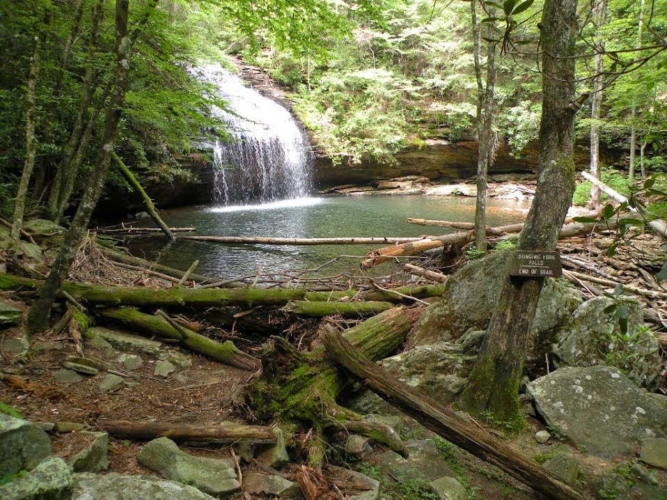
One hot, clear July day I decided to get out and hike and swim. It was very hot and so I picked a short hike. I revisited Stinging Fork Falls. I had been a couple times before, but it is always pretty.
I enjoyed the short hike to the falls and went swimming in the plunge pool and ate my lunch while there.
The wildflowers and forest and attractive along the hike. I also went out to the overlook above
the falls. Indian Point or something like that.
Self explanatory kiosk
Pretty view along the trail to Stinging Fork
Trail to Stinging Fork Falls
Mini mo-mos! Sensitive Brier. along the path to Stinging Fork Falls. If you touch the leaves they fold up immediately.
Stinging Fork Falls
Next I was not quite ready to go home and I had the way points with me for Jewett Falls.
I decided since it was not too far away I'd try to visit that as a little adventure. Good thing I have my dark little sense of humor. I found it but OH! What I found.
I found this lake.
And below the lake I found this privvy... a kind of human litter box it seems.
And I found lots of trash. see above and below
and a little further down I found what is left of Jewett Falls
This is the top of Jewett Falls. You can walk around the bank and see it from the base, but there is no water coming over it now.
The lake construction dammed the creek and now no water but a trickle ever goes over these once lovely falls. Man's reach has usually exceeded his grasp and in the case of this land owner.. I'd say that is certainly true. Its his prerogative to construct a fishing lake, but at the cost of a naturally occurring waterfall on his property.
Based on what I saw there.. he'd do well to heed this along with a lot of other human pigs who have no sense. See the warning to litter bugs I posted below.
Because the entry got damaged, photos lost, and it was deleted.
I later found the photos to re-do it so I am going to repost.
I am in the process of repairing damaged blog entries.
I am also totally reorganizing my photos on all fronts.
It is going to take time. When I ever get it done I will never
post another photo on Flickr again... ever.
We set out originally today to visit Powder House Falls and Ray Falls and neither of those
worked out. We had the waypoints for Gooch Creek Arch with us and that is what we ended up doing since we were in the area.
We went down toward Dayton and went up the old Evensville Road to the plateau level.
We then went out a gated road that parallels the bluff line through what appears to be a pine plantation.
We knew the arch sat out on the edge of the plateau. It did not take too much time or searching to find it.
Just follow the old road out and turn to the left. It is a pretty and unique spot.
**Edited to Add** I heard from a fellow who visited the Gooch Creek Arch with written permission in hand. He was met by some individual on the property who told him to get lost he was not welcome. He proved he had written permission and was still met with hostility. He wisely decided to leave. I am glad he told me of this because it shows the spirit of the persons involved with the place. Clearly one landowner was generous and reasonable while others are not. It isn't worth the hassle of having your mellow harshed. It ruins it. I don't know who the person was who did the running him off, but shame on them. I hope one day our nation gets Right to Roam laws and there is nothing folks like that can do anymore.


 View from Overlook #1