

Bloodroot in bloom.. one of the earliest Spring wildflowers
Cap Rock Window and Lost Cane
Dana & Kenny Koogler
Saturday March 23, 2019
Pictures are here starting with frame 52
We had originally planned to go to Jamestown and hike to Anderson Falls and Cap Rock.
We would spend the night at John & Sharon's and visit with them. We'd get up the next day and go riding on Skinner Mountain and explore Lost Cane. I misunderstood their plans , and believed they'd be gone the next day to the airport by the time we got up. I thought Sunday was the morning they had to pick up granddaughter Emma. Thankfully we got the nice surprise that they did not have to pick her up til Monday morning. We packed up and headed out to do our hiking first at Big South Fork. We took the RZR along, but did not plan to use it here as it is foot travel only.
We had never been on the Terry Cemetery Road. It is a far piece back in the woods.
We parked and there was not a soul back this far. We discussed what we wanted to do first?
I thought Cap Rock was the logical first hike since it should be fairly straight forward and short. We could then drop down toward Anderson Falls. Today we outdid our all time record.
Let the new record show that:
We made the trip to Cap Rock Window harder than it had to be both going in AND coming out!
We started off down the Maude's Crack Trail. We found a turn off path to the left about where we'd expect it. It was more or less a manway. You could see a bit further in that it was flagged and was being traveled. We were still picking our way among downed trees and somewhat heavy heath vegetation. Blueberry bushes and briars and dead weeds were all around. The terrain was not terribly steep, but we came to the edge of the bluff where we could see Cap Rock Window. All we could see from here was the Cap Rock itself. We could not get down from here and thus far had spotted no way down in the immediate vicinity.
We had seen lots of flags on the way and both figured we'd missed a turn. We reasoned that we must have to drop down a drainage and go round below the bluff line to find the base of Cap Rock. We back tracked a short distance and turned to cut across the knoll we were on. We came to another edge of the bluff that was not nearly as steep and led to a downward drainage.
We went down and around and found that we had come up way under Cap Rock. Fortunately the effort involved was not wasted and with a little more pushing forward and up we were able to reach the base of Cap Rock and get a view of the window.


Above: Cap Rock Spire
It is a forty-five foot sandstone spire carved out long ago in the days when the plateau was part of an inland sea. It also goes by the name Totem Hole because it looks like a totem pole with a diamond shaped hole in the middle. It is a fascinating formation and we'd never seen one like it! It has all sorts of tiny pebble inclusions and delicate micro arches and pits along it.
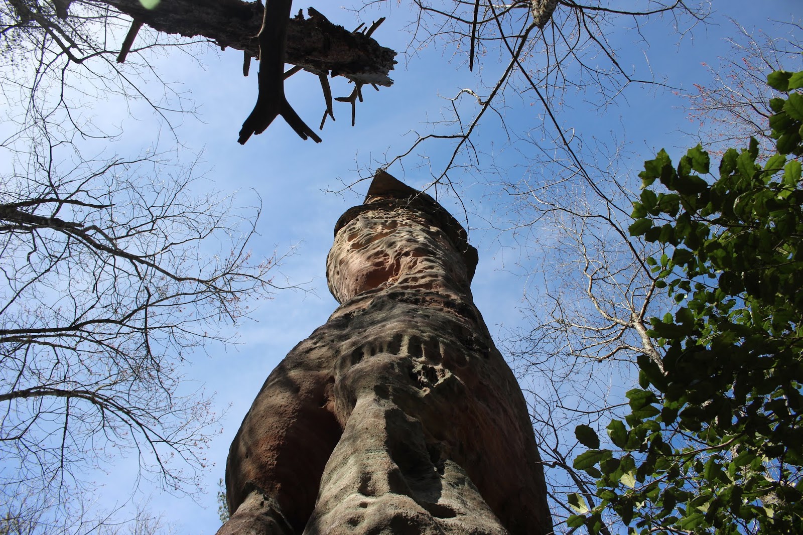


A photo to show the steep drop off around the base of the spire. We had done some climbing to get here from the bottom.
We enjoyed checking out the spire, but the terrain was steep and rather narrow. Kenny set about figuring if we could get back up from here without backtracking? Indeed we could. He came back laughing. I knew we'd done it again. Only this time we had really messed up. We failed to see a very old flag that indicates a spot where you can make your way down over the bluff at the far left of the spire. We came back up that way huffing and puffing and holding on to rhodo, but happy not to have to go back the way we'd gone down!
It is worth mentioning that there are tons of neon orange and pink survey tape flags in the area. That is partly route finding, and the routes are numerous because there are quite a few noteworthy land features in that one tiny area! I won't try to mention them all, but will include the link to Cap Rock Window and you can click Nearby landforms or open the map and they will be displayed. The one we missed that I really wished we'd taken time to see was Russell Arch 100x 30. ( aka Morning Arch) Any subsequent trips we will hit that up and Maudes Crack as well. I noticed in looking up the way point for Cap Rock it is listed as
2x3 and that doesn't inspire anyone to visit a feature. When you look at the photo though it is far more interesting than a mere 2 foot by 3 foot window!
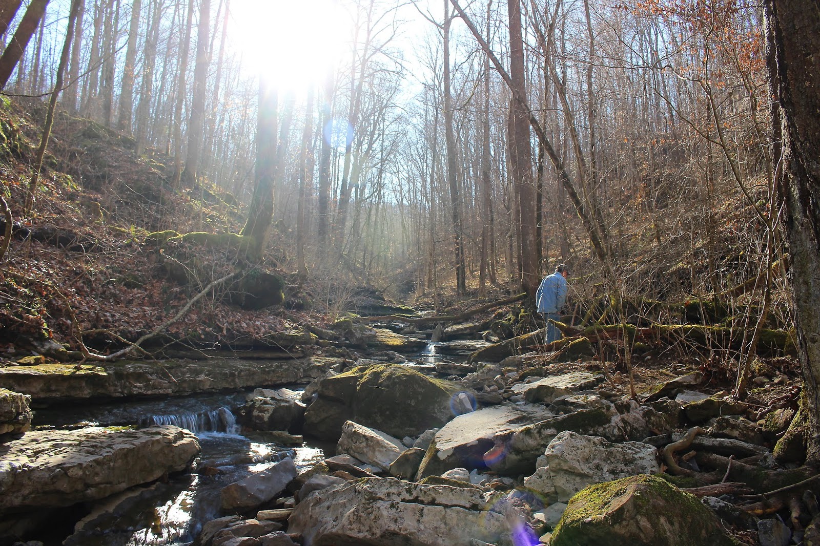
Our hike back to the truck was easy and level. We came back to find numerous other hikers had shown up. We talked to some ladies who had questions about the area. We helped them get sorted out. If only they knew who they were asking and how we do things. We realized on the hike back that at our current level of fatigue and the lateness in the day we'd best not attempt Anderson Falls today. We figured we'd do something simpler today and visit with John and Sharon. We'd get up in the morning and go see Anderson Falls when we were rested.
Meantime while we're in the area we decided to try to find the nearby Terry Lynn Arch and Kamtt Tunnel and Alta Falls 29 ft. We set off following some flags, but soon the terrain got stupid and the flags played out. We found a falls, but it was a bare trickle and I don't believe it was Alta Falls. Kenny said he was not going to continue this toil to see a 12 x 3 arch.
We headed back to the truck.
We sat down and ate our lunch and pondered what we'd get into next.
The hikers we spoke to near the Terry Cemetery at the end of the road.. told me about something fun they were doing. They are participating in the Go Big Challenge 2019 that Big South Fork puts on each year. It is one of the most fun challenges I've ever read. It has something for practically everyone! They give you lots of ways to earn points and win prizes.
I downloaded the book and made some calls about it. I think I am going to do it.
Part Two of Our Day--Lost Cane
We went by Wal-Mart and grabbed stuff to fix for dinner and called John and Sharon to tell them of our change in plans. They were busy doing work around their home. We went by the house and visited with them. John was dog tired from all they'd be working on. Sharon was also, but went up the mountain with us a short distance on Skinner Mtn. She has grown weary of dealing with the extremely rough road on the way up. It is harder to cope with on a four wheeler. I can't say I blame her. She turned around and headed back at some point.
We continued on. The mountain was bleak looking thus far. I saw no leaves on the trees and only a few bloodroot blooms popping up. We got stuck in a deep mud hole and turned over on our side. I crawled out the top end and hooked the winch cable to a tree and helped Kenny pull us out. Well,we got that screw up out of the way for the day. ha! I looked down at my feet where we'd gone in the mud hole and I was standing by the largest clump of frog eggs I'd ever seen!
We kept pushing on into Lost Cane. We found the turn at the big intersection and headed down into the big sinkhole within the mountain. Lots of water flowed down the trail, but when we got to the first couple falls they were barely flowing at all. Just drips! So waterfalls 1, 2 and 3 turned out to be just drippy. Further down the mountain and waterfall #4 was dry. Not enough flow to even be a falls today. Waterfall #5 was shooting out of the bank as always.
I was not motivated enough to climb down into that hole to see it. I had other things on my mind. Waterfall #6 also not flowing. Waterfall #7 was flowing as usual but not so strongly.
It was still beautiful down in here and just as intriguing to me. We would head round to Franks Flume and see that and follow the stream up further today to see what lay ahead on it.


This rock always reminds me of the ruins of an old structure, but it is just mossy rocks.
We made our turn toward Frank's Flume. It took longer to get back there than I recalled. I was also surprised at the features I noticed today that I had never paid attention to before. Lots of wet weather waterfalls along the way. One of which needs closer investigation because I believe it is a spring fed waterfall that runs year round. We did see a few bloodroot blooms and they were very pretty.
 Above: Bloodroot booms.
 Above: Frank's Flume
 Above: especially clear water flowing away down Lost Cane Creek around Frank's Flume.
We stopped to admire Frank's Flume and the marvelous volume and clarity of the water. We also pulled over and walked up the stream bed from here. It was super slick in places.
We made it further today than we ever have, but still did not make it to the ten foot falls we got stopped at trying to come down it from above. We'll try to explore as much of the creek as we can . The goal ultimately is to follow it all the way back to its headwaters and find out if it emerges from anymore caves. It may just be a normal stream but we don't yet know.
 Cascade above Frank's Flume. One of several.
 Beautiful hole of blue water at the foot of this cascade.
 Above: Glorious golden light flows into the gorge deep in the belly of Lost Cane sink. I love walking down here when the sun is like this.


 Above: A view of the whole eighth, un-named falls
 2nd drop
 3rd drop
 4th drop
 Cave entrance where the stream comes out.


We made our turn toward Frank's Flume. It took longer to get back there than I recalled. I was also surprised at the features I noticed today that I had never paid attention to before. Lots of wet weather waterfalls along the way. One of which needs closer investigation because I believe it is a spring fed waterfall that runs year round. We did see a few bloodroot blooms and they were very pretty.


We stopped to admire Frank's Flume and the marvelous volume and clarity of the water. We also pulled over and walked up the stream bed from here. It was super slick in places.
We made it further today than we ever have, but still did not make it to the ten foot falls we got stopped at trying to come down it from above. We'll try to explore as much of the creek as we can . The goal ultimately is to follow it all the way back to its headwaters and find out if it emerges from anymore caves. It may just be a normal stream but we don't yet know.


 Above: Glorious golden light flows into the gorge deep in the belly of Lost Cane sink. I love walking down here when the sun is like this.
Above: another cascade above Frank's Flume. Sun makes for terrible photos, but I'll take it after this gloomy Winter.
Below is a video of Frank's Flume and the cascades we found above it.
We ambled around awhile then made our way carefully back to the RZR. Once back we headed out of the arm of Lost Cane that holds the flume. Back at the big intersection I asked if we couldn't go a bit further down just to see if anymore flowers were blooming? Kenny agreed. I then had time to work on him a bit more. I reasoned that I did not want to go back the way we'd come. That it would take longer and be more difficult. I begged to come out near the hog pen down on Boatland.
It is a rough sumbitch, but shorter. I reminded Kenny of the bypass trail that knocked off so much of the horribly rough stream bed filled with boulders. He did not look too happy about it, but said if I was sure we'd go for it. Go for it we did. Twas a good thing.

A shot of the muddy stream trickle that did not match up with the roar of water I heard!
There was not a lot to see on the way out in any direction you wanted to go. Things are still dull and dead for the most part. We came to a spot that we encountered a downed tree big enough to require cutting with the chainsaw. I took the opportunity to get out with the camera and photograph the few blooming flowers. Beside us lay a muddy, small stream by the trail. Even over the grinding of the chainsaw I realized I was hearing water. Way too much water to be coming from the pitiful little muddy stream to my left. I began heading in that direction as fast as I could plowing through brush and briars and mud as I went. It was only a matter of a minute until I could look up the bank before me and see a four level waterfall cascading down the slope! It was beautiful. I'd found an eighth waterfall down in this hole. Many times as we've been here it continues to surprise us pleasantly. I climbed all the way up. Kenny came after me and was admiring the beautiful falls as well. He beat me up the slopes since I was lingering to shoot photos and video footage.
I finally made it up there and could see very quickly that the stream emerged from a cave. We'd at last found the second cave in Lost Cane. We'd been looking for it for three or four years. Flowers bloomed along the slopes here. A few trout lilies in bud and some rue anemone, hepaticas and chickweed. We were both ecstatic. We needed a day like today. It felt like a big win!
**Edited to Add**
I have included the info for Cap Rock Window, but not for Lost Cane. It is part of Skinner Mountain WMA which you can look up. Tom Dunigan some time ago shared with me that he really did not want anymore waterfalls added to the database that were wet weather falls. I would say that most of the falls in in Lost Cane fall into that category. The majority of them do not flow for much of the year. Those that do are still influenced by rainfall in their volume. While I love Lost Cane and so does Kenny others might find it not as interesting. Additionally while you can walk down into it.. most of the trails leading to it are long and not friendly to foot traffic. Mud holes and immense rocky stretches would not be fun to travel especially if you went to all that effort and didn't find what you were looking for or found it and it was not looking too swift.


Just inside the cave passage.. we did not have proper lights or gear so we did not go in this time, but we will in the future.

Looking as much like a fuzzy white bottle brush as anything.. Allegheny Spurge blooms on the slopes around the eighth falls.
Below is a video of the eighth falls and cave.
We finally loaded up and hit the trail since we still had a ways to go. Sharon was fixing dinner and we wanted to get back to tell them what we'd found and visit with them. The way out turned out to be indeed shorter and simpler. The bypass trail is still in business and avoids the crux. It will beat you nearly to death trying to come down that rocky stream bed. It takes forever unless you have a heavy duty machine and know the way around some of it.
We came out at spot along Boatland and were glad to see it.
Kenny said he needed to ride up to the top of the hill to see something. We went up there and there is activity going on near the River Trailhead access. He informed me that Mr. Smith is going into hemp farming! I was tickled to hear it. He is not going to cut off access to the trail and has merely re-routed it to the left. What a super nice gesture. He didn't have to be so generous, but we are sure happy he did. I am a big believer in the hemp industry and hope it turns out to be an economic boon for Fentress County, other poorer Tennessee counties and Kentucky.
The CBD business is helping many folks overcome addiction and all sorts of health problems and robbing Big Pharma of their fortune they make treating symptoms. I want to see more regular folks able to feed and care for their family and less drug company reps wearing Brooks Brothers suits and driving flashy cars.
Below: Prepartions by the Smith's to go into hemp farming. I find this all fascinating and hopeful.

We went back to John and Sharons and shared our good news of our find. Kenny is making plans to take them each up there to see it. We had a delicious supper prepared by Sharon. We caught up a bit and then hit the sack. I woke up in the morning after a good sleep with a stopped up head and sinus headache. I took nasal spray for it and thought it helped, but it didn't. Kenny took me to the drug store and I took something, but was getting worse and worse. Bummed out I just wanted to go home. Everyone was understanding of my situation and we headed to the house after we said our good-byes. I felt better that evening, but by Friday was super sick. We all had the GI bug!
Been down in lost cane a lot lately. Looking for this cave! We've found a few but not this one!
ReplyDeleteWe can show you where it is perhaps in April. Sharon called me today to see if I'd house sit for a weekend. We'll be over there. Be an opportune time to show you around and you can show us what you've found as well! April 17, 18 and 19th!
Delete