

write as then and now comparison... better time to see colors of Fall on this drive is 2nd week of Nov. questions answered. new questions brought up. goals.
new facts learned.
Bottle gentians blooming along Joe Brown Highway yesterday.
Joe Brown Highway-- Coker Creek to Murphy and Back
Dana & Kenny Koogler
Saturday Oct. 31, 2020-Halloween
(gallery is a collection of photos from various trips. Open the link and when you are on the first photo click the right arrow to advance to the next frame.)
It is no secret I love to drag around on backroads exploring. Kenny does as well which is why we are a good pair. We have long had questions about some things down in that far flung corner of Tennessee and North Carolina.
We decided yesterday to go seek out some answers as well as pretty scenery. I have written about Joe Brown Highway several times before. One of the intentions I had before going today was to come up with some instructions how to drive this scenic backroad and help the traveler select points of interest along the route. I am going to hold off on that for now because I came up with more questions that answers. I realized I am still not prepared with enough accurate information to undertake such a project.
I learned yesterday that while I thought I had driven Joe Brown Highway through from end to end I have not. I have been on parts of it, but never fully gone the entire length in one trip. What I thought was the route was actually side trips on roads that connect to it, but that is not the true historic road.
The route begins beside the Coker Creek Visitor Center in Tennessee and runs from there through the mountains crossing into the mountains of North Carolina. It ends in Murphy, North Carolina. In the middle in winds through a number of small communities with names like Unaka,Texana, Grape Creek, and Ogreeta. It stops along the banks of the Hiwassee River in
downtown Murphy. I know nothing of the middle parts. I have been on the far end in Murphy. I have been as far as the Murphy Mercantile, but once there we turned and went either toward the Hiwassee Dam on the access road or turned onto Morrow or Prospect Roads and went along the shores of the lake to see other things.
In due time I'll put it all together and come up with my goal.
I guess for now I'll just write about what we saw and what we did.
We started off in Coker Creek and turned left onto the old Joe Brown Highway there. It is a beautiful country drive. Last weekend we went there and hiked a part of the Unicoi Turnpike Trail and visited Doc Rogers Fields.
Today I was surprised that the colors were not as good as in the past. Many trees that had colorful leaves had dropped them due to wind and rain. Other places were still very green like it was still September. The good news is that perhaps in a couple weeks the road will have another round of beautiful Autumn colors.
Below: the first view along Joe Brown Highway .. out to the Unaka Mountains.

Many places along the route have beautiful views of the surrounding mountains. The road itself and the scenes created by the forest as you drive are pretty in and of themselves. Parts of the drive pass through woods heavy with pine trees. The fragrance of the pine needles and the sight of them lining the roads where they have dropped creating a soft, rust colored fringe.
Copper beech leaves draped low over the road in spots. Up higher in the mountains as the road winds through fiery red leaves of sourwood, ironwood and the orangey persimmon leaves punctuate the drive.
Below: I saw blue bottle gentians in several places along the drive today.
They were another source of color. Nearly all the wildflowers are gone for the year. Gentians, a tiny bit of goldenrod, and a few lone asters were it today!

We came to a place where there was a T intersection. The left side initially appeared to keep going so we turned and went that way. It quickly was apparent it was gated. FR 82 ... heads to Roberts Cove vicinity and nothing special in the mountains. The right side is signed DP4 and also leads nowhere.
Below all we saw here was this pond of stagnant water next to FR 82 below the gate.  Above and below: DP 4 to the right of the highway

 Above: FR 82 to the left of the highway...


Above: pine needles fairly cover the old road and they smell wonderful!
It is always good to see places being brought back to life again!
Below: abandoned house now appears to be adopted and is being put to use.
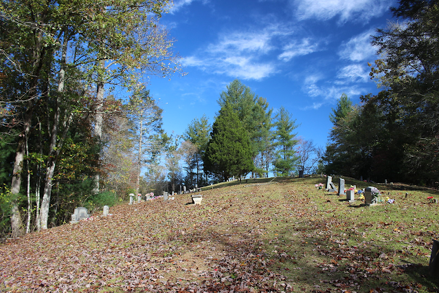
You pass this empty house and curve around to the hill above and behind it to arrive at the chapel and the cemetery. A dinner on the grounds table sits with all the table top missing. Two outhouses... I guess his and hers?? sit on either side of the drive that pulls up to the cemetery. The chapel has some new doors and a few fixer uppers. It now has a sign over the door that says Church of the Dove. I am sure that was not there five years ago.

Above: Poindexter Chapel
Below: Looking up the little knoll to the Poindexter Cemetery.

Below is what it looked like five years earlier.

Below is outhouse number 2 below the cemetery. It is in similar condition to five years ago. Doesn't look to have changed at all.

Next we moved on down the road. We came to the left turn at a marker indicating Morrow Chapel. I had visited it five years ago and while it was a quiet little place I did not feel it warranted another look. It was not as scenic or interesting so today I passed it up.
Below is a photo of it from five years ago.


We pushed onward toward an area where there are several old abandoned houses and barns clustered together by the road. I got some of the best photos there on the first visit. Today it was pretty, but not as good color wise. I still enjoyed seeing the old structures though. Next door to the one house is a nicer, newer house that is occupied and it appears those folks are mowing the back yard of the abandoned house beside them. It allowed me to walk into the back yard and look around seeing the place from different angles.


Below: mossy stone wall by the abandoned house

Below is a photo of an old barn that is just a little further past the abandoned house.

We passed several spots where the road was framed by foliage and the light filtering through the forest just made for a postcard scene. Like the one in the image below.

We arrived at a four way intersection and directly across from us was the Murphy Mercantile. It is a tiny store that sells fresh eggs, veggies, etc. on the honor system. They will also cut your hair!

The signs here indicated that turning left would continue on the Joe Brown Highway, going straight would take us to the Hiwassee Dam. A right turn onto Morrow road was not indicated where that went. I had it in mind that a turn onto that road would lead us toward North Shoal Creek Falls. It was here that I realized we had never driven the entire Joe Brown Highway. We hit the ends near Hanging Dog in Murphy and we'd come as far as this intersection, but that was it. A big portion in the middle we left off.
Today we wanted to visit the Hiwassee Dam so we'd go straight. It wasn't long til we arrived at the dam. The gate to the overlook and visitor center was closed, but you could still walk over there if you wanted. The picnic area was open. We saw one family enjoying a picnic there. The day was warming up nicely.

Below: a nice example of wholesome family fun at the picnic area across from the visitor center. They have additional tables down at the boat ramp!


Below is a view near the dam


We were getting hungry and hoped to get a bite to eat in Murphy so we motored onward. We were fortunate to be able to try a restaurant we'd had our eye on.. Rib Country. It is a good barbecue joint. It was fair priced, fast, clean as a pin, great food. Very laid back. Once we got lunch over with we headed back toward the dam to hunt up North Shoal Creek Falls. We planned to visit that, drive out toward Hwy 68 again at Farner, then drive the Apalachia Dam road. Someone said they thought we'd enjoy it. Below is an image of what it looks like crossing the dam.
Below is a view of the actual Hiwassee Dam
Below: if you're in Murphy, NC try Rib Country. You'll be glad you did.

We did some double checking ourselves in Murphy when we had a phone signal. I was correct in that Morrow Road would take us in the direction of North Shoal Creek Falls. We drove that way, but realized it wasn't right. The creek beside the road disappeared suddenly. We'd missed something. We back tracked and turned onto Prospect and there was Shoal Creek again. Prospect Road is the one it sits beside. We pulled down to the spot where the parking area is. Big signs posted Beware of Dog and No Trespassing. Someone had freshly surveyed the area and marked it. A logging road had been cut into the bank and was heading toward the trail to the falls. I was not sure what to do. I felt like while I wanted to see the falls I was not willing to get in trouble over it. Especially for a falls I'd already visited numerous times. Kenny said he had a feeling this was one of those scenarios where someone had posted the signs, but had no real power to keep people out. He said he was going ahead. I followed him, but felt very uneasy. I felt better when I got down to where I could see more of the surrounding area. Someone has made a trail coming in from up the road and along the stream.
It is better than it used to be. No houses down here or other people. Just the same I snapped a few photos, shot some video and boogied down to get out of there. I didn't want my luck to run out.

Above: North Shoal Creek Falls was splendid today! Running great. Loads of water on that stream! *Note to self.... we found some other answers we'd been hunting for along the shore of the lake near the falls**
We went back to the jeep huffing and puffing up that hill. We grabbed something cold to drink and motored off to complete our loop back to Highway 68. Continued out Morrow Road and came to an intersection with Shulers Creek Road. We would have to turn left here and follow this road out to Rt. 68. The bridge here and Shulers Creek flowing by with the copper beech leaves glittering in the evening sun made a pretty sight.

Shulers Creek with copper beech leaves
We hadn't gone any distance on Shulers Creek Road when we encountered several trucks blocking the road. We weren't sure what was happening? As we approached they moved out of the way. They were hunters transferring a hog over to a truck or something. We stopped to congratulate them on bagging a big hog!
It was a true Russian wild boar. They had Plott hounds with them and those dogs were happy! I love hearing them bay as long as it isn't when I'm trying to sleep.
I can still hear my dad throw the bedroom window up and holler at the dogs "Shut up dogs!" Below is a photo of the hog they killed.

We continued down Shulers Creek Road and encountered several other hunters.
I realized that though I'd driven a portion of this road, it was another that I had more left to see. It follows the Hiwassee River for a good portion of it below the dam. It is that strange river bottom land where the river is all chopped up with chunks of land and trees. It is like that because of the dam upstream.
It is interesting and it has an odd kind of beauty all its own. I think because it is so different.

Above: A side stream heads down to merge with the Hiwassee River. The entire area looks kinda like this. a mixture of trees, clumps of land and grass mingled with water. Kenny pointed out that this might be a good place to take a Spring drive. He said he believed it would be especially pretty in Springtime with the new green leaf buds on the trees. I expect he's right.


Above: Autumn colors on Shulers Creek Road.
We finally came out on Hwy 68 right above the bridge over the Hiwassee River.
I had long wondered what lay out that road when I would pass it. Now I knew!
It is a pretty drive for sure. I hope to go back and do some more exploring.
We headed toward Farner to drive Apalachia Dam Road. We found it easily and turned onto it. It goes along the railroad tracks of the excursion train. It passes through a residential area. It is then gated and no access since 9/11. Terrorism too much of a threat in this remote area. I think they just don't keep enough personnel in this area to really secure it? We didn't find a thing but discouragement out this road so we headed back out to the main road. Kenny drove all through Farner then we headed a bit further down Hwy 68 and today were able to catch Tammy's Ice Cream open for business and us with enough room for icecream!
We met the owners and enjoyed visiting with them and the other patrons.
Everyone was super nice and friendly. We wrapped up our days adventure with lots of ice cream. 

Above: Tammy's Ice Cream stand.
Below is a short video of North Shoal Creek Falls and one of Shulers Creek.
No comments:
Post a Comment
Thanks for reading and commenting. I enjoy hearing from those who read & make use of my blog. I have made some wonderful friendships through emails from readers. I respond to all comments and emails. I appreciate folks reaching out to let me know when my blog entries are not functioning correctly or if the situation somewhere has changed. Many Blessings to you!
Dana 🐝