

Teaberry growing along the trail to Buffalo Arch
Bandy Creek Camping Trip --
Buffalo Arch, Fiddler's Rock, & Mark Branch Falls
Kenny & Dana Koogler
Friday December 4, through Sunday Dec. 6th, 2020
(click the link then the right arrow to advance to next photo)
We have done a fair amount of camping this year. Even so I was not ready for camping season to be over. I was not ready to cope solely with family obligations, Christmas preparations, and the like. I was wanting to squeeze in one more camping trip this year. I actually wanted to go on two, but had to settle for one.
I wanted to stay some place different so I picked Bandy Creek Campground.
It was one of those places we'd talked about for a long time, but had yet to go.
Our friend Matt Snow was staying at Fall Creek Falls and I wanted to go there as well. Kenny said only one more. He has been working like crazy so I wasn't going to argue. My desire for different along with the increasing number of covid cases helped influence my decision. We'd stick to ourselves up at Bandy Creek and social distance. We'd finally see some of the places we'd hoped to see.
We settled on a long weekend first of December. It was supposed to be decent weather, but turn bitterly cold the next Monday! We would enjoy some outdoor time as a couple before things turned really wintery. We got to Bandy Creek and found it rather full of campers! We got the last spot open it seemed. We finally got settled into the site just after lunch on Friday. We talked over what to do and decided upon trying to find Bandy Creek Falls. It was on the list as a desirable off trail hike for years now. I felt confident we'd find it. I had a way point. I'd read every trip report I could find on it. We would get there today or so I thought.
I had read of two approaches to Bandy Creek Falls. One involved going down to Leatherwood Ford and following the river bank up the mouth of the creek and then on up to the falls. The second way was a little shorter and involved going to Burke Fields and coming down to the falls. I had a better feeling about the coming in from the bottom so that is what we tried. We quickly arrived at Leatherwood Ford and parked down in the picnic area. We walked across the bridge and went down the steps at the end. We went under the bridge and crossed a small drainage and picked up the remnants of an old road. We had not expected any type of trail so this was welcome indeed. The going was briary and over and under trees, but we made decent time. We arrived at Bandy Creek itself faster than anticipated. We had to ford which was not bad either. Traces of the old road continued for awhile. We followed it up on the creek right as long as we could.
We were even seeing survey tape now and then! Finally we got to a choke stone in the creek and had to decide what to do. It was at the point of a very pretty cascade. I took the high road. Kenny took the low road. My way was better.
He joined me and we pushed onward.
Finally we found ourselves in a boulder field. One of those messes where every step must be carefully measured. Downed leaves from Autumn made the going slippery. It was impossible to tell if you were stepping on solid ground, a boulder, or into a hole between the boulders. I ran my leg down into a hole up to my knee at one point. It spooked me, but I did not get hurt. Kenny scouted ahead and let me catch my breath. He came back with an exasperated look on his face.
We were within 0.15 miles of the falls. He said the going was going to be extremely rough from that point. He was concerned we'd not have enough daylight to both get to the falls and get safely out of the woods before dark. I could see he was irritated so I told him not to worry about it. We'd try it again another day with an earlier start. The off trail was tough, but we'd call it a scouting mission and just see what took place later. It isn't the first time we'd made failed attempts to reach a falls and had to try again.
Below is a set of images taken along our exploration of Bandy Creek from the bottom up. It is quite pretty and very rough past this point. I quit taking photos once the terrain demanded my 100% attention.


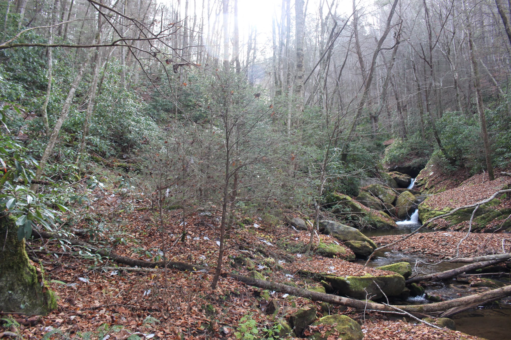


Below is a short video of the beautiful and tranquil Bandy Creek.
Sensibly we turned and headed back toward the vehicle. We took our time on the way enjoying the vistas along the stream. I find something very soothing about being in the woods off trail alongside a stream that few others will ever visit.
We headed back toward the campground. It felt good to me and Kenny both to finally be doing something we'd talked about for a couple years now. The campground was really nice. I have finally grown to really love our camper. I missed our other one so bad when it got torn up. I knew it was going to take time and making some good memories in the new rig for me to learn to love it. I have arrived! We took a little time this evening before supper to put up some decorations we'd bought for the camper two years earlier. The homey touches really help make it special to me.

We drove out to the Oscar Blevins farm to hike around a little bit.
We'd never done any hiking in this area. It was very nice. It is an easy hike.
Lots of history here and the sign boards tell all about the Blevins family farm operations. 
Saturday
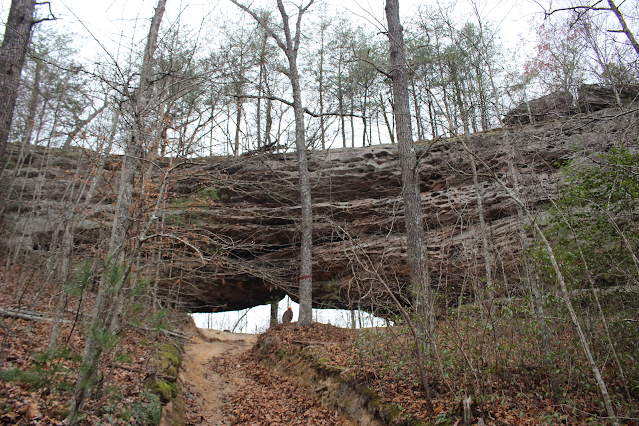
We got up Saturday and headed out to visit several attractions on the Kentucky side of the Big South Fork. We started off with a hike to Buffalo Arch. It is a short hike to a very dramatic arch. We were the only vehicle here this morning in the parking spot. We encountered a group of four adult hikers arriving to hike as we were leaving. Otherwise we had the place to ourselves!
Below: we've arrived at Buffalo Arch(click the link to the location of Buffalo Arch)

Below: a vantage from beneath the arch looking to the side

Below: looking directly out from the arch back toward the trail

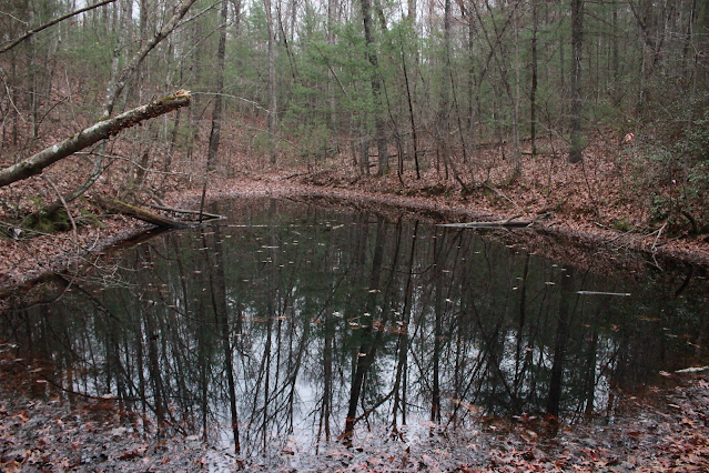
On the hike there we did not see a whole lot of other exciting things, but we did see two worth mentioning. We found an abandoned metal set of steps or ladder laying by the trail. We passed a black pond on the way.
The black pond is just down over the bank from the metal ladder.

Above: Kenny ponders the purpose of the metal ladder or steps.
We did see a little lingering Fall color in the woods today. Below a tiny sapling with some bright red leaves still hanging on. This may be a sourwood tree sapling. Not 100% sure.

Once we'd visited Buffalo Arch we hiked back to the jeep and proceeded to our next stop... Fiddler's Rock. It is a spot where rock carvings have been placed in a flat stone in the ground. It has been vandalized already by current day graffiti artists who felt the need to leave their mark of V.B.+ T.G. and that sort of nonsense. The rock was the site of a gathering spot for dancing. The fiddler stood on the rock and provided the music.. and the road that ran past it was the dance floor. It is possible if you know what you're looking for to see the traces of the old road through the forest in front of the rock.
Below is an image of the rock with as much in one frame as I could get.
It has a cowboy, a rifle, and the fiddle carved in it. If you click the image it will enlarge to full size and permit a better look at the images.


Above is a closer look at the rifle carving and the cowboy. Jonathan felt it important to carve his name in there. I have a feeling that is a more recent carving.
While I will provide a link to the location of Buffalo Arch I will NOT provide information on the Fiddler's Rock. It has already been abused by vandals.
Increased visitors will increase the likelihood of more damage. We encountered another prime example of this right after we left here. Thanks very much to the person who helped me locate it. I am keeping your trust and my word by leaving out directions. Thanks also to Chuck Sutherland who vouched for me being trustworthy. It made a difference!
Below is a short video of Fiddler's Rock that illustrates it better than photos can.
The next planned stop was Mark Branch Falls. I had seen it in my guide book 100 Hikes in Big South Fork by Russ Manning. I got to looking at my Big South Fork map and the location of the falls. I recalled seeing a waterfall listed on Tennessee landforms' database of Big South Fork features. On there it was listed as Startling Falls. I took a waypoint along for Startling Falls and plugged it in for later use. I had a distinct feeling that it would lead us right to Mark Branch Falls.
On our drive out Parker Mountain Road we looked up to our left and saw a massive natural bridge or arch in the forest high above us. We turned around at the next possible spot and headed back. We had passed a vehicle coming out of a side road and we suspected it probably lead to the arch. We were able to stop the people as they passed us to ask. They indicated yes, the side road went right up to the arch. I asked the dude if he knew the name of it? He said "Not right off the top of my head". So it had a name already, but not recalled by this guy. I turned on the GPS to put a waypoint on it just in case I needed it later. I named it Parker Mountain arch for now. I recalled seeing
on the map of the area something that made me wonder. A feature named Hollow Rock.
We walked up the dirt ditch to the massive arch. Kenny was up there talking to himself and as I got close enough to listen I got tickled. I turned on the video camera and caught part of it. He was making fun of all the graffiti tags beneath the arch. "Tap Daddy" Tapley. Tapman. Tap tap taperoo!
Tap man and Big Bubba. Bros. 4 Life. dumb chit like that.
Click the link further up the trip report and you can easily go visit this if you want to! Please don't take along your spray paint or vandalize the arch!?!
See the image below with all the graffiti. Sad. This is an example of why I don't tell where somethings are.

Once we'd gotten back in the truck from seeing the arch I pulled out the map and did some checking... we were at Hollow Rock. This massive arch is it!
I went in the GPS and changed the name of the feature to the correct one.
Below is a video of Hollow Rock and me laughing at Kenny's tap tap tapperoo.. mocking the fools who had to spray paint all over the arch. Tapdaddy wherever you are... I hope someone spray paints you in your sleep.
We continued toward Bell Farm and our destination.. the trailhead for Mark Branch Falls. The views along the way and the countryside were very pretty.
We saw very few people all day long. We passed a few historic cemeteries and this old falling down house shown below.

More quickly than we thought .. we arrived at the trailhead for Mark Branch Falls. It lies along a section of the long trail Sheltowee Trace. I don't think I'd ever hiked an inch of it until today. It was quite pretty! Parking is along Peters Mountain where there used to be an old fire tower lookout. The anchors for it are all that is left of the tower. Restrooms and parking and waste baskets are available at this spot. The area has lots of trails and possibilities for some reasonable length day hikes. 


Below: I am holding up a huge umbrella magnolia leaf.

We ate our lunch at the Peters Mountain trailhead. I got out the GPS and turned it on to "Startling Falls" waypoint. I would test my theory about Startling Falls and Mark Branch Falls being one and the same. The directions in the guidebook were not to the falls specifically. They are for a section hike of the Sheltowee Trace. It is a 46 mile section hike so the guidebook directions are not ideal for picking out a hike to one specific waterfall in the area. I had to do some studying on it the night before to reckon which way we needed to go. I was correct and so our hike to the waterfall did not take a long time.
The forest is open and the trail well maintained. The day had warmed up and the skies were now blue. We had shed layers of clothing. The air was fresh from rain and cool. The forest smelled of Autumn leaves and pine. It was quiet except for an occasional bird song or the trickling of the streams.

Our hike lead us to the brink of a rock bluff where a stream plunged over.
The guidebook described that we should be able to stay on the trail and arrive pretty quickly at the base of the falls. It wound around the rock amphitheater's sides and down down down a set of rock steps into the basin where the waterfall landed. It was in a small plunge pool that disappeared under ground then resurged in 25 feet. The GPS did lead us right to it. Mark Branch Falls and Startling Falls are one and the same. It is about 65 feet high. The correct name of it would be Mark Branch Falls since that was the name given based on the stream name in Russ Manning's guidebook that predated the addition of Startling Falls to the database, but Tom just added the Mark Branch monaker to the original entry. It was a neat area and a pretty falls. It would certainly be more dramatic after a heavy rain, but we weren't complaining. It felt great to be out in the woods just us. No kids fussing or needing something.


Below is a video of Mark Branch Falls
We headed back to the campground after our hike. We fixed steaks on the grill and baked potatoes. It was a good ending to our day.
Sunday
We had originally planned on staying Sunday night and heading home on Monday morning. Kenny's work has been crazy busy right along. It turned out we'd not be able to stay Sunday night, but we had paid just the same. We'd at least be able to stick around as long as we wanted. We figured we'd leave early enough to get home and put things away. We'd give Kenny time to rest up before having to go to work on Monday. We had a nice breakfast and then set out for attempt #2 at Bandy Creek Falls. Today we tried coming in from Upper Burke fields. It was another failed attempt to reach the falls, but that is par for the course with us. The terrain up here is extremely steep. We ended up hiking out to the Leatherwood Ford Overlook for the view.
See the photo below.

I ended up running it past Tom Dunigan once I got home and had a signal. He agreed with me and said he'd not try it from Burke Fields but would go upstream. He has not yet been, but I trust his judgement.
We will try again soon and see which way works. I have a feeling Kenny is going to hog tie me and take me down over the bluff despite my objections.
He is convinced this will work. Ben Garrett has visited it both ways so i know it is possible, but I don't know the route he took from above.
We went back and hiked along the old White Pine Road that follows Bandy Creek. White Pine Church used to sit over in Burke Fields. Now it is on the opposite side of Hwy 297. The old road was through a hemlock forest and quite pretty. We saw lots of evergreens that smelled wonderful. I found and ate some teaberry!

Above: teaberry growing along the old White Pine Road
Below: Old White Pine Road-- if you approach it from Burke Fields this is the view. If you go down to Hwy 297 and start in you will see a super short paved section then it becomes a dirt track.
 Old White Pine Road from the Hwy 297 side... starts off as paved but dwindles down to the view below...


You can see pavement, but the ground is overtaking it.. reclaiming it.


Below is a view of tranquil Bandy Creek


Above: a spring flows down to merge with Bandy Creek. It looks like the drum of an old washing machine has been left to rust there by the spring.
We enjoyed our prowl in the woods this fine Sunday morning.
We went back to the camper and packed up after lunch and headed home. I napped in the truck on the drive home. All in all it was not the most exciting camping trip we've ever taken, but we had a good time just the same. It was satisfying to fit in one final camping trip this year before Winterizing the trailer. It was also nice to get away for awhile where it was just us. No grandkids. No kids. No one needing something.
Thankfully at the time I am typing this up .. much delayed.... our son, daughter in law, and two grandchildren have moved into a larger house. They are happy and it feels good to be able to be an old couple again. I always have mixed emotions especially about Gabe. We are very close with him having raised him for awhile. It is hard to change gears between him living with us... and then not being here.
I feel like I'm never satisfied. I can't get anything done or get a minutes peace with kids here, but when they are not here I miss them.
I am hopeful that 2021 will be a more normal year for me and Kenny. And for everyone.
No comments:
Post a Comment
Thanks for reading and commenting. I enjoy hearing from those who read & make use of my blog. I have made some wonderful friendships through emails from readers. I respond to all comments and emails. I appreciate folks reaching out to let me know when my blog entries are not functioning correctly or if the situation somewhere has changed. Many Blessings to you!
Dana 🐝