I have been trying more lately to actually get out and see the places I list or daydream about. Instead of just making lists and then going off on some new tangent... sticking with the list! I had long admired the old railroad grade passing by Middle Fork Falls in the Oliver Springs area. I had visited the main falls by the road before, but had not taken the time to explore further.
I decided to do something about that. I had a long list of spots to check out in Morgan County. I spent a fair amount of time doing my homework. I study the waterfalls, abandoned railroad lines, or whatever I'm hunting. I also try to find logical, safe, out of the way spots to park. Failure to do this can lead to finding a feature, but then not being able to access it.
I got up on a sunny Winter day and drove out to Morgan County with my gear and food packed. I parked at the Middle Creek Church and walked from the parking lot across Hwy 62 down Back Valley Road. I had seen a pull off across from the falls, but since the church parking lot was so close I opted for that instead. I figured it was safer. It only took me a couple minutes to find myself at the brink of the falls. I could see the top of it from the road.
It is situated down in a holler by the road. I had to approach it from a bit downstream in order to go safely down the embankment. It was clear to me based on the manmade improvements and signage it is a baptizing hole for the local church. It is a small, but very pretty falls and worth the short trek to see. It would not be worth making a special trip for on its own. It is 10 feet high.
Above: Geise Creek Falls has a pretty blue hole of water. The morning sun creates golden and russet woods surrounding it.
Below is a video of it:
I wanted to see Back Valley Falls which is very near the first falls.
The link above is the Tennessee Landforms page for it. Looking at the photograph on that page it is not too impressive, but I had seen a different photo by Chris Oliver on Flickr. It was a very nice 14 footer during higher flows. I knew today it would be running well.
I could not identify a spot along the road where I felt safe pulling off. The road is pretty well traveled and very curvy. I just had a bad feeling about it.
I picked out a spot to park, but I could not tell if it was okay or not? I later found out from a friend that would have been okay. I will have to try again to visit it. I won't make a special trip, but will batch this visit together with other sights and make a day of it in the future.
Once back at my jeep I continued further up the road toward Middle Fork Falls. It is across from the Beech Grove church. It is a nice roadside attraction and visited by a fair number of persons. There is a good sized pull off by it. There is a lower falls and there are un-named falls dropping in from wet weather drainages downstream. I had only taken time to visit the main falls. Today I would remedy that.
Below is a photo taken from the brink of the falls. I loved the blue hole of water at the base.
I walked on down to the base of Middle Fork Falls and set about seeing it from different vantages. I was blessed to catch a rainbow in the falls in the photo above!
Below is a shot that is just the obligatory front of the falls photo. It is a nice one.
I have been to this falls too many times to count so I did not tarry at the base of it. I walked back up to road level and entered the woods above the falls. I was heading for the path of the abandoned railroad grade that is on the opposite side of this stream. I soon got a treat I had not counted on.
From over here you get an unobstructed view of the entire Middle Fork Falls and what's better is that it is far enough away from it to get a really good look at the complete falls!
Below: a photo of the chunks of ice and snow still lingering in the shady spots
Below: A great view of Middle Fork Falls including the upper cascade from the old railroad line.
Below is a video of Middle Fork Falls from many view points
One of the things that happened by waiting 18 months to write a blog entry is the forgetting of way too many details, history, and the source material for the historical facts. I found the video I made of "Stevens Switch Spur" on YouTube and thought "Oh! this is cool. I want to know about that. I want to go there!" only to realize that: 1. It was my video and 2. I HAD been there. It was at that point I got down to brass tacks about fixing and catching up my blog.
I will attempt to briefly explain how that rail line came to be.
I cannot guarantee the historical accuracy of the info. If anyone reads this and knows it is incorrect it will not offend me to be brought up to speed.
I welcome it! I did finally learn that Tom Dunigan has the "Stevens Switch Spur" on the Tennessee Landforms page for Middle Fork Falls and mentions it there. It is the ONLY place I can find reference to it.
Below: the old prison mine on Brushy Mountain. Coal was hauled out of here and put on a train from here.
It appears the stretch of railroad ran from Brushy Mountain Prison and the Frozen Head Coal mines all the way through Petros, Stephens, Coalfield and then bears south/southwest toward Harriman where it ties into the Norfolk Southern active line near Hwy 61 today. It was the Southern Railway line or a spur of it. Next time I am over that way I want to make a point to check out that spot to see what goes on there? I also want to see if there are still minnow rearing pools along the edges of the Emory River the way the old map shows?! The freight trains brought coal out of the mountains and if you look at the old maps there are former mines all along the route of the abandoned line. Note to myself: Yes, I did search the term "Stephens Switch" to see if the spelling Tom used and I copied was incorrect. It yielded nothing.
Below: This photo was taken at the start of the old railbed
Below: the second photo is taken a bit further down from the main falls on the old rail grade
Below: a tiny cascade drops off the rocks near the old railroad grade
Below: down toward the Lower Falls on Middle Fork I found this well constructed stone drainage culvert. You can see drainage structures like this all along this stretch.
Above: I am about mid way down what you can hike of the railroad grade
Above: a mossy cross tie from the railroad tracks
Above: some hollowed out logs along the way
Below: one of the side streams that has an un-named falls on it.
Above: crumbling banks at the end of the line for me.
Above: Another un-named side stream with a falls before the end of the railroad line. It is cluttered with debris.
Above: these rocky bluffs were above the side cascades
Above: You can see the railroad bed keeps going, but for me this was the place to stop. The banks on either side were so loose and crumbling that had I climbed down here I'd not have been able to go back up the other side. The only way out of here was down the stream/waterfall that helped erode this spot. It was unsafe.
Above: A nice series of cascades on Middle Fork that lies between the upper and lower falls
Above: moss coated rock formations on the banks around the stream
Above: Looking down into the gully between the two parts of the railroad grade. The photo does not illustrate very well how deep this is.
Above: I get my first glimpse of the lower falls. No matter what I tried I could not get a satisfactory vantage point to view the falls from over here. I had to turn around and go back. I was not giving up though.
Back at my jeep I sat down and ate lunch and got something to drink.
I then walked down the road and was able to very carefully get a photo and video of Lower Falls on Middle Fork. Below is the photo. It was a fun day and I really enjoyed myself. It felt great to scratch something off my bucket list that had been on there for so long.
And finally below is the video of the lower falls.
It is note worthy that while hunting for historical information on this trip I did turn up a couple interesting abandoned railroad history bits.
In following the old map to see where the old railroad ended up I found that a large chunk of abandoned railroad crosses Ish Creek and still has bridge supports in two spots! I want to go check all that out. I think it is possible there is an abandoned tunnel in Greenback area. We shall see.
Below is a map of the spot along Ish Creek across from the boat ramp
**Notes to self** Three contributing factors in me thinking this blog entry had already been written were 1. I used the Geise Creek Falls photo on the front page as a cover. 2. I posted the trip photos complete with captions on Facebook. 3. I posted the videos to Youtube.
It is a good thing I did post the photos on FB because by the time I wrote this I cannot find my original photos on my computer. They may have been deleted. I also have not come up with any on my Smugmug photos account.
I realized after my last visit to Harmon Den to clean up Little Fall Branch Falls that I was growing very bored with this area. I have enjoyed being part of Waterfall Keepers, but I was worn out with the monotony of visiting this area.
It really hit home during the time of year when not much is blooming, and there was not a lot to see or do. My clean up duties did not take long thankfully, but I knew I needed to remedy this. I decided to adopt Alarka Falls which has always been special to me. I submitted my application and let Waterfall Keepers know what I was considering. I will likely keep Alarka Falls and let Little Fall Branch Falls and Lemon Falls go in 2022. I will at least see these through in this current year. The year was half gone, but I could at least get in a Summer clean up of top and bottom trailheads at Alarka. I would also fit in an Autumn clean up.
I had quite a few things I wanted to do over in Cherokee and the vicinity.
I considered using some of our rewards points to get a hotel room for a night or two. Kenny asked me one evening if I'd like him to take the camper over for several days to a week? I readily agreed. It is always more fun staying in our nice camper than in a hotel room. He made arrangements to pull the camper over to Happy Holiday RV Village. I was excited about it. He went round I-40 and Waynesville to come in. I went across Hwy 441... Newfound Gap Road since I had to take my jeep for the week.
Oconaluftee Pioneer Farm Museum
One of the things I wanted to do was stop off at the Pioneer Farm Museum.
I was hoping to find the farm garden looking good and some of the heirloom flowers and gladiolas in bloom. I arrived to take a quick pit stop amid a huge crowd of visitors. I was able to find a parking spot near the original visitor center. I took a leg stretcher walk to the pioneer farm display. It was buzzing with people. It did not take long to see that the garden was not even planted. It was a mess of weeds. The heirloom malva hollyhocks were not up. The irises were spent. The gladiolas did not bloom at all. Bummer. So much for that. I did check out the old farm buildings briefly and take a look at the river flowing past. It was not a bad stop, but somewhat disappointing.
Oconaluftee Pioneer Farm
Outhouse at Pioneer Farm Museum. Someone is working on the flowers. Not pretty this year though.
Inside view of the house wash basin and pitcher
Inside view of house, bed, fire place, sewing machine, rocking chair. above hangs a quilt frame.
Oconaluftee River in the shade
Blue Ridge Parkway & Balsam Mountain Road
I got in touch with Kenny to see where he was? He was at Waynesville. I had about an forty-five minutes to an hour until he arrived at the campground. I decided to go ahead and try to see some of the views and the purple fringed orchids on Balsam Mountain. I got behind a mowing outfit along the parkway.
That cinched it for me. I was determined I was going to see those orchids before they got mowed down! I went ahead as quickly as I could. I did stop to see some native azaleas, mountain laurel, and views in addition. Mostly I hunted orchids. I had visited here in the Fall and this past May so I was not keen on hiking or checking out everything this go round. I would keep my focus on the purple fringed orchids. I believed in the past I had photographed both large and small purple fringed orchids here. I was apparently mistaken. My friend Betsy Lee went and found all of them to be the small sort. I thought perhaps she just missed seeing the large ones? If I ever photographed large ones there you could not prove it by me. I found she was correct. Every single one I found was the small sort. Platanthera psycodes... the ones with the barbell shaped nectary. So that means I will need some time next Summer to try to photograph the large ones. The views today were magnificent! The day was clear and beautiful. The temperatures were nice and cool up high. Azaleas were everywhere. Mountain laurel also bloomed, but was past its prime. It was a worthwhile side trip. Although I learned the mowers had already been along Balsam Mountain Road, the orchids were still standing. They did a good job.
Yellow orange flame azaleas blooming on the parkway
View off the Blue Ridge Parkway at the intersection with Balsam Mountain Road
Mountain Laurel turning brown on the edges on Balsam Mountain Road
View from Mile High Overlook
Reddish orange flame azleas on Balsam Mountain
Beardtongue blooming along Balsam Mountain Road
Purple fringed orchid
Me pointing out the barbell shaped nectary opening on the orchid
Pretty trio of purple fringed orchids... all of them small. The large and small don't have anything to do with size. It is the shape of the nectary opening that helps determine which one you are seeing.
Once I got done checking out stuff on the spur road and parkway I headed on toward the campground to meet Kenny. He was going to have to head home tonight for work in the morning, but we would have until night to spend together.
Happy Holiday RV Village
Monday
Happy Holiday RV Village is the campground we stayed at back in May.
We liked it so much we decided we would give it another go. It is well run and neat. It has a swimming pool, playground, and a store. I brought my swim suit in case I wanted to give the pool a try. I ended up not doing so mainly because the water was not horrible, but was a rather murky color. I don't think they keep it as clean as they possibly could. It was greenish. All in all it was a nice stay.
I would stay here again. It turned out a bit stressful because Kenny had to work all day Thursday and I had to be out of there by eleven a.m. on Friday. I spent considerable time all day Thursday fretting over whether he'd get there or not?
I won't ever go through this again while he is working. I wouldn't have cared to have to stay until Saturday morning, but I won't worry anymore if he is going to make it back to tow the camper or not.
Duck pond at the campground with its fountains
Pool and playground at the RV village
The Koog-Mobile Cruiser all set up. Apparently this is going to be the last trip taken in that camper. Another one is on the way and this one is to be sold!
Soco Creek flows through the campground
I don't spend a lot of time in the campground regardless, but I got some odd looks from the neighbors. Who is this strange woman with her vehicle full of tools, trash bags, buckets and so forth? I know it looks funny to see a Grandma dragging in with mud and dirt on her and work gloves and boots on. Keep 'em guessing.
While there I did manage to drive 2 miles up the road and visit Bearmeat's Indian Den. I bought a new bird feeder for myself since mine got torn up when someone backed over it recently. I got some anti itch lotion for Summer rashes from weeds. I also got Lydia some Kickingbird Pottery for her birthday. It was a nice visit to the store. My only regret is that I had to leave on Thursday and Greg and Stormy Warren were at Bearmeat's on Friday. Bummer.
Before Kenny went home Monday evening we went grocery shopping.
There is ONE grocery store in Cherokee. Food Lion. They need to get the tribe another and better grocery store. Bad enough for me to deal with as a traveler. I cannot imagine coping with that day in and day out. We had supper together and Kenny motored on home around 8 p.m. I watched tv and read and did some fixing up and organizing of the camper. I would not likely have bothered had I known then we were about to sell it.
Whittier & Upper Alarka Trailhead
Tuesday
Alarka Falls has a trail to it from the top on the Whittier side.
It also has a trail to it from the base on the Alarka side. It is hardly ever accessed from the top trail. I think the "trail" up top is actually an access road for the Nantahala National Forest. It has been a really pretty hike in the past, but it has gotten very overgrown and boggy. Kenny and I planned to rent a wheeled string trimmer and come over to clear it out one weekend. I figured in August. I decided I would start up top today to determine if it still needed clearing? I did not want to pay for an equipment rental only to learn the work had already been done.
I came round from the Qualla Boundary into Whittier. I pulled over near the railroad tracks to take pictures. It is a very quaint old village with some oddities.
Railroad tracks in Whittier
Side view of this old building next to the tracks.
Front on view of the building by the tracks. It is mainly a facade! The material is not brick but paneling! I would love to know what the purpose of this structure is?
A very old house by the tracks. I had read somewhere this was a boarding house back in the day.
I continued up the mountain on a long, winding road until I arrived at Wesser Gap. I stopped here and got out to hike some of the side trails. I also picked up trash starting here and going all the way to the upper trailhead. I saw some sundrops, some mountain laurel and native azaleas, but not much else in the way of flowers. A few fire pinks also. I cleaned up two campsites, but thankfully there was not a whole bunch of trash. I only gathered up about 15 gallons of trash from the entire area. Much of what I picked up was deeply embedded in the ground as if it had been there a long while. That is also good news for hopefully it will not accumulate fast again.
I won't give an in depth account of the attempt to hike the upper trail out to the top of the falls. I got about half mile out the 1.50 mile trek to the falls and encountered a terrible situation. One part of the trail is so boggy and the mud so deep it nearly sucked the boots off my feet. I made it out to the Christmas Tree plantation part and past that just a little ways. I plowed through chest high grass, weeds, and briars. I was extremely concerned because I could not see my feet. I just knew it was a bad idea to continue lest I get snake bit. About the time I decided enough was enough I looked down and there coiled up in the middle of the trail or what was left of it... was a big snake. I am not sure if it was poison or not, but I screamed and tore out of there. I was over it. I made it back to the jeep in record time. So yes! Hell yes! the trail needs cleaned out. And It isn't going to happen during hot weather. If Kenny will go back with me during the Fall before they close this road I will do it.
I had to park across the road from the trailhead usual parking spot.
It is because someone has been pulling up fence posts designed to keep people out of the fields at Pigpen Flats and going four wheeling there. The trailhead parking spot is a quagmire. It has actually dried up some since May, but it is still bad. I stopped to pick up a little trash there. I could hear a conversation down near the creek. I hoped I wasn't about to run into some undesirable character. I got in the jeep and headed out toward the stream. I was going to drive up and hike to Cowee Bald lookout tower. A smiling man was standing there messing with his cell phone and his two chocolate lab dogs were in the stream. I was very relieved to see it was only a couple friendly someone's instead of a crazy person. I had enough scares for awhile.
I pulled down to the creek and stopped. I got out to take pictures of the dogs.
The man laughed and told me "He ain't gonna git out unless you come on toward the creek." I let him know I just wanted to take the dog's photos which I did. One of them came up to greet me. I petted his head and got in the vehicle to ford the stream. It was so deep that I had to get over far as I could to the right. This was perfect because the other dog was lying down in the deepest part of the stream to my left. He was so hot and enjoying the stream so much he never got up. I waved to him and his nice man and went my way.
Above: sundrops
Azalea in bloom along trail 86F
This is 86F ... in a good spot. I did not dare take photos in the bad places.
Trail 86F in a real open spot. Back when the whole trail was like this it was a pleasant walk.
Above fire pinks bloom on 86F
A nice man and his two chocolate labs cooling off in the creek.
I made the Lincoln Town Car Turn and headed slowly up to Cowee Bald to hike to the tower. It was a pretty drive and there were a few things blooming. Goatsbeard, bowman's root, azaleas of a few different colors, fire pinks, beardtongue, sundrops, and virginia spiderwort were in bloom. I saw one white Clinton's lily in bloom. The only one I've seen this year. I saw huge masses of deep green ferns. I crept along enjoying the wildflower display. I saw a rabbit and some turkeys.
I pulled over and parked at the turn around spot near the gate for the tower access road. I hiked from the gate to the tower which was about 1/2 mile one way. It was a nice gradual hike and the temperature was comfortable. The air smelled fresh and the scenery was nice. I did not see anything too exciting, but it had been ten years or so since I last visited the tower. I got up the first sign of man made enterprise past the gate. It is a row of communications buildings and equipment locker buildings. I listened to the low hum of technology up here on this otherwise quiet mountain. It reminded me of an episode of The X-Files where Mulder goes to Aricebo in the jungles of Puerto Rico to check out the SETI project (Search for Extraterrestrial Intelligence) and alien mayhem ensues. 👽𝐗 The Truth Is Out There!
I was glad to be past the drone of communications equipment. As I approached the tower I was treated to more native azaleas and a large cluster of Virginia Spiderwort. The view to the east of the Cowee Mountains was serene and silent. The mountain range ambles along in shades of blue and green capped by a froth of white fluffy clouds.
Above: a view through the frame of the Cowee Bald tower of the mountains in the distance. What a beautiful view!
Cowee Bald tower from the far side at the bottom. The vignetting makes it look like it is against the globe!
Above: I am sitting on the top steps of the tower looking back the way I came.
Looking out from beneath the tower
Virginia spiderwort
Cowee Bald Tower. I noticed the addition of a plywood panel over a window!
Beautiful green mass of ferns along the access road
Native azaleas were the flower of the hour up here today.
I sat down on the steps of the tower and checked out the view around me. Aside from bird songs and the breeze all was quiet here. It was very soothing. I wandered around the bald looking for flowers and interesting things being vigilant against anymore snake encounters. At last I began my return hike to the jeep. I took my time and enjoyed the solitude and exercise.
I drove slowly back down the road and thankfully did not encounter any vehicles on my way. I had the place to myself other than the guy and his dogs earlier today. I never saw a soul hiking.
Beardtongue blooms along the Cowee Access road
The part of the bald that was mowed and burned was filled with beautiful wildflowers. Fire pinks, beardtongue, spiderwort and whorled loosestrife.
Flame azalea buds
The ford of Alarka Creek minus the dogs. 🐶
Once I got back down to the ford of the stream I finished up picking trash at last. I then realized how tired I had gotten. I had been at it all day. I think between the work detail and the snake scare adrenaline I was just wrung out. I headed gradually down off the mountain and back toward the camper. That would have to be enough for the day. I arrived home to find the neighbors sitting around sipping tea and reading the paper very leisurely. I come dragging in muddy, scratched up from briars, sticks and leaves in my wig, toting bags of smelly garbage. Hoo boy. Garden club lady, I aint. At least not today.
Lower Alarka Falls Trailhead
Wednesday
It rained on Tuesday night into Wednesday morning. The rain was out of the area by around 11 a.m. I had an early lunch at the camper so I'd not have to pack a bunch of stuff. I then headed out toward the Alarka Falls trailhead to maintain the lower parking area and trail. It had been five years since I last visited the falls from this side. The Mountain Jedi, Mike Maples was along on that trip as well as groovy Hiker Mike Gourley.. the musician/hiker/peak bagger. How we have all missed Mike Maples since his passing away in 2019. He is now hiking in Heaven with Jesus and his friends and family.
I hoped I would not have any difficulties with the ramps for the US 74 Expressway. I remember one trip where Tina and I got on US 19 and were heading who knows where. I paid closer attention this time and was sure I'd be okay today. It is 10 miles to the trailhead from the time you leave the expressway. Long ways back in the country to get there. No phone signal either. I found it with no problems. It is very straightforward.
I was not surprised to find no one at the trailhead. I spent considerable time picking up trash and doing maintenance before I set off on the actual hike to the falls.
A nice couple I met while I was at the falls. Andrew and Geneva of Chapel Hill, NC. It was their first time at Alarka Falls. It was the first time I've encountered people there who did not come with me. All told I saw six people today hiking to the falls. A group of four and this couple. I asked their permission to take their photo and put them on the interwebz. I also invited them to join Waterfall Keepers!
Alarka Falls
Above: Alarka Falls.. the main drop of the falls. It is a couple hundred feet high. Can't see it all in one view.
Alarka Falls from further down the trail
A lower cascading section of Alarka Creek
Above: My jeep parked at the lower trail.
Above: a look around the parking area showed it to be immaculate once I got done. I picked up every speck of manmade trash I could find. That doesn't mean it won't get dirty again. All it would take is one Beer Drinkers and Hell Raisers Weekend to ruin it all. I did not see a speck of any kind of trash on the trail to the falls or around the falls itself.
I enjoyed my visit here today. I had a real feeling of satisfaction when I left and headed back to the campground.
I woke Thursday morning a little stressed out. I was fretting over getting out of there on time. I made myself get out and drive over to Lake Junaluska. I had for nearly a year been wanting to visit the area. It was only twenty miles from the campground. I dearly despise Route 19, but it was the shortest and simplest way to the lake. I just stuck with it and found the place with no problem. I had studied the map of the grounds so I at least had an idea where I was going. I did not get to see everything I wanted, but most of it.
I stopped to check out the Bethea Visitor Center first. It was not yet open. I just enjoyed the garden there in front of the place. They had some beautiful flowers especially lilies!
Coneflowers, daisies and lilies at Lake Junaluska
Coral colored lilies and white calla lilies
Below: a brightly colored variety of Italian Lords and Ladies
Above: peach colored tiger lilies and daisies
Next I headed on the short distance to the Rose Walk. It was easy to find and sits along the north shore of the lake. It was far longer and prettier than I'd imagined! It is a popular place for taking walks for lots of people. I drove past the Corneille Bryan Native Garden which I found easily. What I did not figure out until after this trip was where to park in order to see this garden? It sits in a residential area. It is necessary to park along the lake shore and walk into the cul de sac up into the garden.
Rose walk
Below are some of my favorites from the walk.
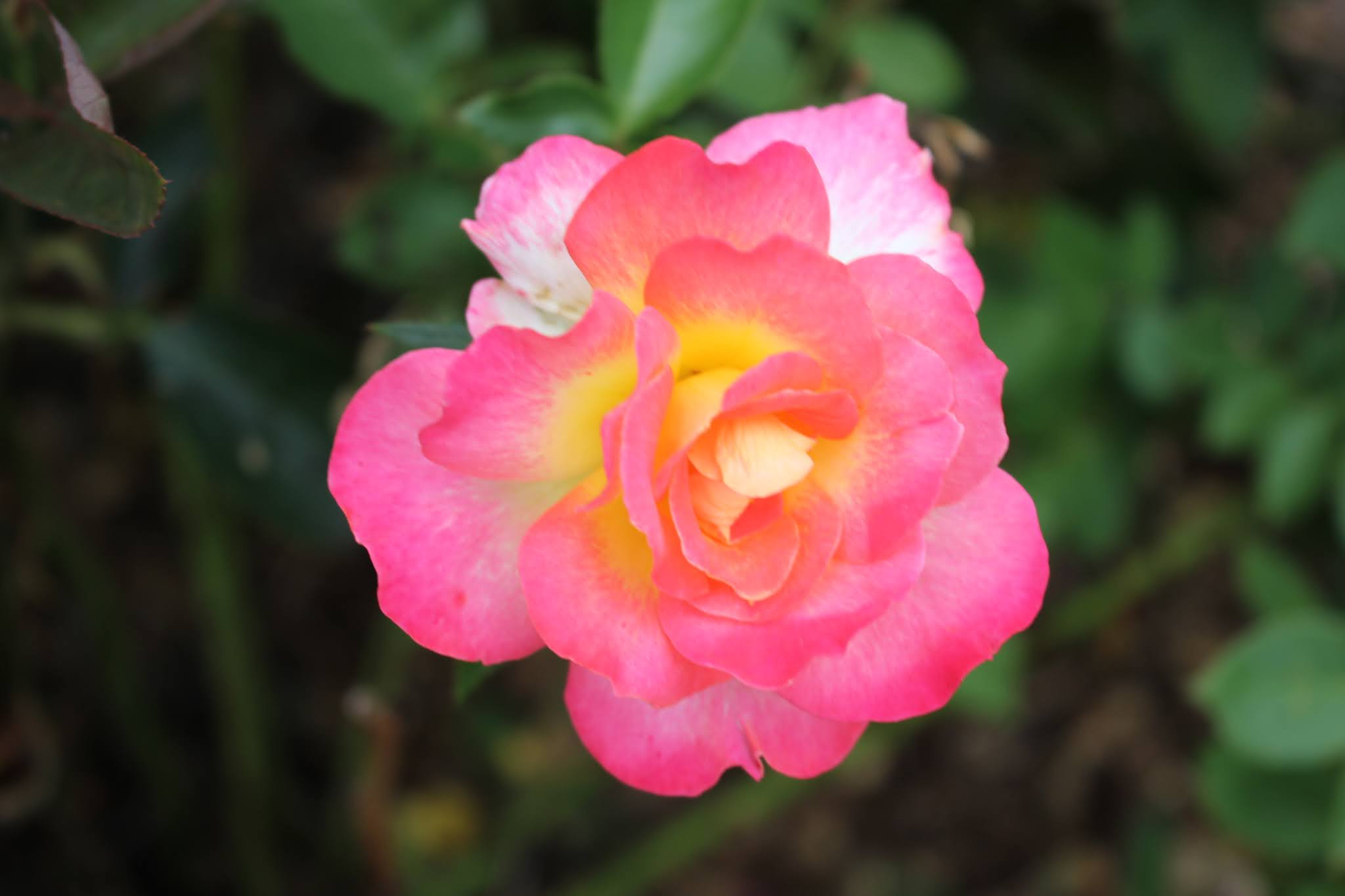
yellow rose
Opening Night Rose against Lake Junaluska
above: a multi flora damask rose. I think this one is my favorite of all.
Above: the pedestrian bridge across the lake.
I went to the Susanna Wesley Garden next. It was real pretty, but not as colorful as the rest I'd seen thus far. It is a quiet spot for meditation and prayer.
Above: Susanna Wesley garden
I then went on to the Memorial Chapel. It was idyllic. It is this old stone church with arches set against the backdrop of Lake Junaluska. It looks like a scene from a fairy tale.
Above: Memorial Chapel
Below is a view of the arches and rose garden
Above: archway and petunias
I enjoyed the chapel and the flowers around it, but moved on to the next spot. It is a pier jutting into the lake. A man and his son were there taking pictures of swans and eagles! I saw a nesting pair of bald eagles up in the tops of hemlock trees. I got a photo, but it was such a poor image you can't tell what it is up there.
Below is a stunning view of the surrounding mountains across the lake.
Above: pier sticks out into the lake
Above: old boat house along the lake shore
Above: at the end of the pier is this sign "Be still and know that I am God. " Psalms 46: 10
I enjoyed my visit to Lake Junaluska, but I was growing a little agitated. I decided I'd best get back to the camper. I was no longer having fun. I missed quite a bit more than I'd thought after a second review of the map and the Lake Junaluska website.
Right now we are having to hold fast to that scripture above. Kenny's mother is passing from this life rapidly at age eighty-eight. His brother and nephew are both battling cancers. It is an all around tough time.
For all my concerns Kenny did make it to pick up the camper around 8 pm. I helped him get things battened down for the trip home. We got home around 11:30 p.m. and fell into bed like two zombies. We were exhausted.
It is good to go, but also good to get home to your own bed. It is not as fun to be away from home when big, serious things are happening in the family.