

Red Wake Robin trillium
North Carolina's Mountain Treasures Series--Santeetlah Headwaters
Wright Creek Falls
I had become aware thanks to Kevin Adam's NC Waterfalls guidebook that a waterfall
existed on Wright Creek. He mentioned that it was a tough bushwhack to reach, and in his opinion
not worth the trouble. I later learned that it lay within the NC Mountain Treasure area of Santeetlah Headwaters. In addition to the waterfall there were big trees to see. Unfortunately the area is rife with a lot of dead, massive hemlocks which are falling. Some have fallen across the falls.
ENTS has been to the area and used LiDar to measure some of the champion sized trees of other species still living, but all the giant hemlocks are now either fallen or dead standing. We saw one that was four feet across easily. The top had broken out of it and was hanging suspended like a dead- fall trap over where we stood at one point during our trip. Nothing for it except to make tracks and get out of there!
I had studied the map of Santeetlah Headwaters which includes Huckleberry Knob and
the Santeetlah Bluffs. I purchased my first ever USGS quad map in order to have a
more accurate map of the area with as much detail as possible. I thought I saw where the falls should be on Wright Creek since I had no waypoint. One thing I thought that turned out to be correct?
The terrain back in that area looked to me like many waterfalls were possible. That much is true, but some of them are very small, choked with rhodo and not worth the extreme effort to reach. I expect some of them dry up to a trickle in Summer. We made an attempt to reach it back in Winter by crossing Santeetlah Creek and coming up from the bottom. It was unsuccessful. We did find another falls that day though that was not listed. My rationale for why that approach?
The terrain back in that area looked to me like many waterfalls were possible. That much is true, but some of them are very small, choked with rhodo and not worth the extreme effort to reach. I expect some of them dry up to a trickle in Summer. We made an attempt to reach it back in Winter by crossing Santeetlah Creek and coming up from the bottom. It was unsuccessful. We did find another falls that day though that was not listed. My rationale for why that approach?
- It was closest to where I believed the falls lay
- It is usually best to approach a waterfall from below it.
- It is usually easier to locate a stream from the mouth of it as opposed to coming in from the top. A headwaters can mean many rivulets and springs to pick from making it hard to narrow down exactly which stream you want to follow.
We did not succeed that day, but thought better of it. We figured we'd wait until we had a longer day for more light. Slightly warmer temperatures and slightly lower creek levels having to ford the Santeetlah. I figured in the mean time I'd try to gather as much information as possible from
every source. I didn't know how that was going to happen, but I'd see what I could do.
Below is a video of an un-named waterfall on Santeetlah Bluffs.
I let it be known that I was interested in locating that falls among my pals on Facebook.
I also did some more searching and found on World Waterfall Database that they showed the falls
much higher in the headwaters than I had thought it would be. I was not sure what to make of it.
I had personally witnessed their data being sometimes very accurate. Other times totally inaccurate.
I was not going to rely solely on that as my resource. Meanwhile the Lord sent along help in the form of Mark Morrison. He is writing another one of his awesome guidebooks and Wright Creek Falls will be included in that. I will rework this blog and include the link to his guidebook when it is finished and ready for sale! Mark is a tough hiker and tackles some rugged terrain in out of the way places. He tends to include some really great waterfalls in his books that you won't find elsewhere.
Going to take a moment to plug Mark because he deserves props for his work.
He gets Kenny Koogler's seal of approval more than any other guidebook writer.
He gives the best, most clear, concise directions. He writes wonderful, inspiring trail narratives, but when it comes to the directions portion of his book he nails it every time. Mark provided me with
some help provided I did not give out the details or directions. For now I'm just saying we went and where. Not how. I will tell you simply it was a good thing we did not attempt to reach it the way I believed we should.
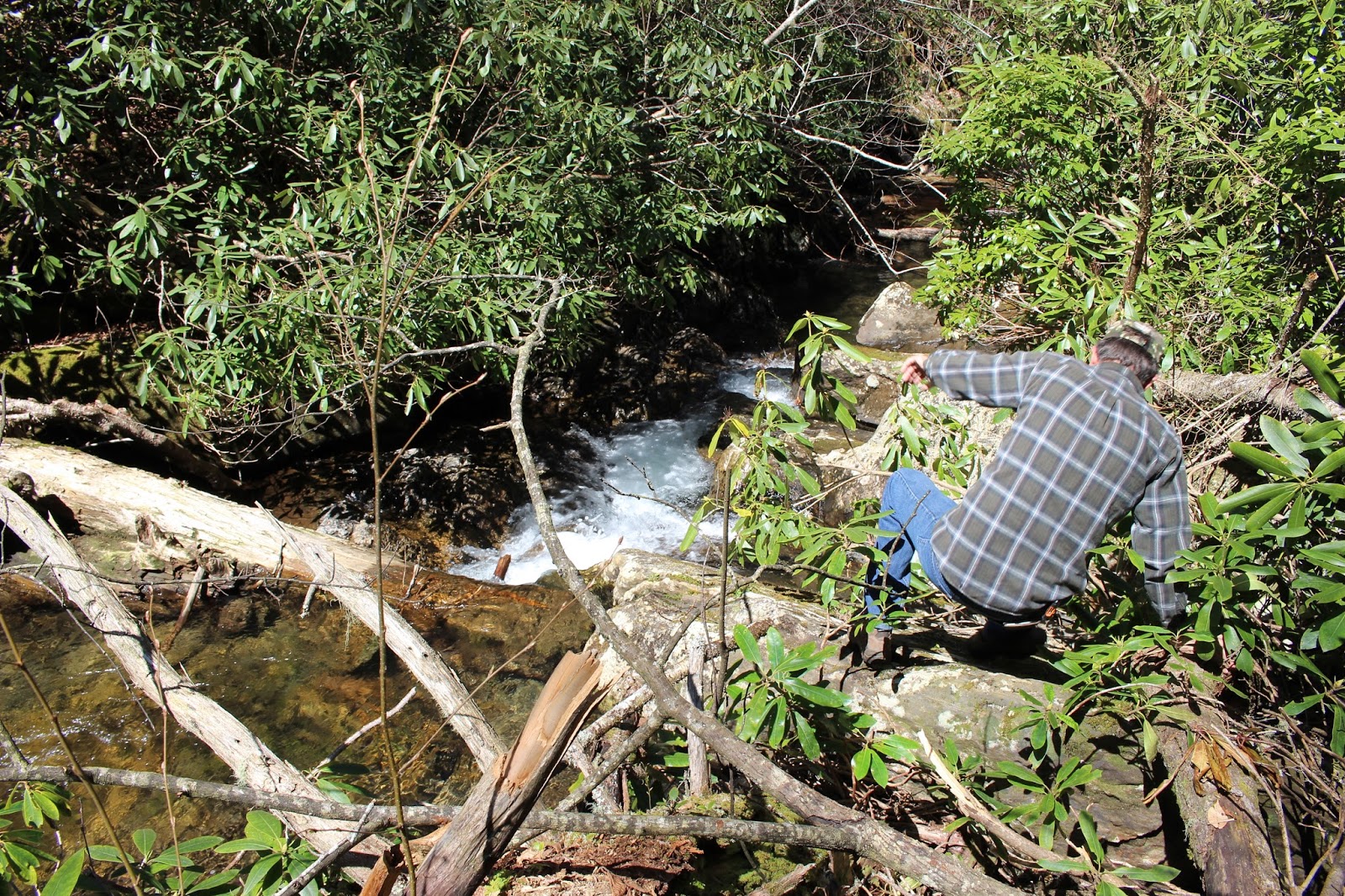
 One of many springs in the headwaters. Imagine trying to pick which one is the correct one.
 Plenty of rhodo. Love/hate relationship with it. Hate climbing thru it. Love having it to hold on to when the climbing gets steep!


This hemlock was four feet across at the base. The top is broken off and hanging suspended in the limbs of the next tree over. We did not realize until we were on our way back out that it hung like a deadfall trap over the place where we stood.

Saw this little guy sunning himself today. First snake of the season for us.
Harmless garter snake.
We had been able to hear the waterfall roar early on. Always a good sign! This was our first glimpse of it.
 Wright Creek Falls
 Fin of rock with resurrection ferns and moss atop it. The area is rugged and beautiful. Didn't see any wildflowers in this immediate area though.

Our view of the eighty foot drop of Wright Creek Falls. You can see the hemlocks down in the bottom. It is a pretty falls for sure. Right by it on the left is yet another falls that is smaller. Then over from that is another one coming in from the opposite side.

Harmless garter snake.
We had been able to hear the waterfall roar early on. Always a good sign! This was our first glimpse of it.


Our view of the eighty foot drop of Wright Creek Falls. You can see the hemlocks down in the bottom. It is a pretty falls for sure. Right by it on the left is yet another falls that is smaller. Then over from that is another one coming in from the opposite side.

Tiny bit of the waterfall to the other side. The view was very obstructed.
We are up high here to get a view of the main falls.
 We realized we would probably not get the best vantage of the falls from the base, but we did it anyhow. We worked that hard to get here so might as well. The terrain is so steep and rocky and choked with downed trees and rhodo it doesn't give you much choice where to go or to stand.

We are up high here to get a view of the main falls.

Kenny climbing around on the rocks, logs and sticks at the base of Wright Creek Falls. Getting to the bottom was more climbing under and over rhodo and hanging on to roots and shrubs.
Once we had seen all we wanted and taken photos we headed back slowly.
We ate lunch at the vehicle and rested. We were thrilled we were able to find it and enjoy seeing this falls. It was worth it to us. I didn't get to see any wildflowers, but I had a backup plan for that.
I didn't want to do a lot after the exertion of the first bushwhack. Kenny also didn't get a lot of sleep the previous night and craved an early return home. I figured we could stop by Jeffrey Hell and I'd check out a few flowers there and we would go home.


Jeffrey Hell trail is a good Spring wildflower trail. It was early though for up here. Not a whole lot blooming yet.
 Dutchmans britches all over this hill.
 Closer view of Dutchmans britches .
 Saw smaller amounts of squirrel corn. It is a relative of bleeding heart.
 Saw lots of trout lilies. This specimen was six inches tall!
 Saw lots of Sweet Betsy.


Once we had seen all we wanted and taken photos we headed back slowly.
We ate lunch at the vehicle and rested. We were thrilled we were able to find it and enjoy seeing this falls. It was worth it to us. I didn't get to see any wildflowers, but I had a backup plan for that.
I didn't want to do a lot after the exertion of the first bushwhack. Kenny also didn't get a lot of sleep the previous night and craved an early return home. I figured we could stop by Jeffrey Hell and I'd check out a few flowers there and we would go home.
Jeffrey Hell
We headed back the Skyway toward Tellico Plains. It was a beautifully clear day today.
We stopped by Jeffrey Hell trail. Kenny did not want to go with me so I went alone. He kicked the seat back and rested while I hiked a little more. It was like going back a month in time being here at this elevation. Carpets of spring beauty all along the slopes by the Skyway including here.
I saw loads of dutchmans breeches, squirrel corn, trout lilies, spring beauties, violets of blue and yellow, toad shade trillium, sweet betsy, cream and red wake robin. It was a worthwhile stop.

The green on the slopes is spring beauty. goes on and on like this.

These little bitty pink and white striped flowers are what you see in Spring beauties.
Some are a little deeper pink.


Saw some cream wake robin. It was very pretty.

Purple Toad-shade trillium. Saw a few of these.

We had a gorgeous clear view from the Skyway today. This photo of Spring in these mountains
is the first one I've taken that really shows the bronze and red tones of Spring blooming trees
as well as the pea greens!
We had a good day. Perfect weather. The plan came together for us this time.
Saw a lot of beauty. Got home in time for Kenny to rest while I fixed dinner.
Below is a short video of Wright Creek Falls from the different views up top and down at the base.


