Every time Kenny and I get out on the canoe two things happen: 1. I am waiting for him to swamp us into whatever body of water we happen to be navigating. 2. The conversation turns to "we should buy a bigger, more stable boat". A recent trip on Calderwood Lake had resulted in one of these bouts. We were discussing it more seriously this time. Which would be better a john boat or a pontoon boat?
Last weekend, Kenny, Gary and Kash headed up to Norris Lake and returned home with a nice, new to us, pontoon boat. It is very attractive, far more stable, and no doubt we and our family and friends will enjoy it.
Below: I'm in the bed and Dolly the cat is laying on me purring. She knows when I am sick and tries to fix me. Both my cats think putting their booty hole up close to my nose will remedy any problem.
above: the magic butthole.
We are learning about pontoon boat ownership. We are also learning that we need to keep the canoe for there are places a pontoon boat will not be appropriate on the water. The canoe still has its uses in smaller streams. I spent Thursday and Friday in bed sick with flu like symptoms after having oral surgery on Tuesday. Saturday dawned and my symptoms were gone. Friday was the day Hurricane Helene
blew through from Gulf of Mexico hitting the Big Bend region of Florida making landfall near the Steinhatchee River area.
It devastated the coast where it hit. It flooded Atlanta for the first time ever. It blew through our area and all we got was enough rain to raise the rivers and water table back to normal and relieve our drought. East of us along the border of East Tennessee and Western North Carolina the scene was apocalyptic. Walters Dam, the Nolichucky River dam, Lake Norman dam all breached. Cocke County Tennessee, Erwin in Unicoi County, Watauga North Carolina, and Asheville all took the brunt of the eastward edge of Helene. Highways 26, I-40, SR 107, Highway 64, were some of the major arteries along the road system that were damaged to the point of shut down. The village of Chimney Rock, North Carolina was obliterated. The Lake Lure dam came close to failing. The Flowering Bridge was damaged. The road was destroyed.
It felt like a real strange form of synchronicity that I was so terribly ill and down in the bed. Ibuprofen, tylenol and cold medicines were not really relieving my symptoms. Meanwhile Helene was barreling toward land. About the time the storm passed in nature I finally woke up to a pain free morning with the illness gone.
Saturday was a slow start for me and Kenny. We'd not made any plans because of my illness as well as the weather. Finally I told him I thought it was a damn shame we had this boat, but it was just sitting up there in the back yard un-used. He set about getting us ready to go. I packed our gear and picnic lunch. Around 11 am we set off toward the lake for the maiden voyage of this craft which as yet is un-named.
Above: pontoon boat in the back yard. Just sitting there.
All the recent rain would surely have gotten our area waterfalls flowing once more. We would head to Chilhowee Lake and check out five waterfalls that are "paddle to landforms". It would be the day to start learning about our pontoon boat as well as discovering more things about Chilhowee Lake. It is the closest lake to us. We can reach it by heading down Foothills Parkway and there we are!
Above: new boat drivers seat.
The drive on Foothills Parkway is always pretty. Fall colors are just beginning to show up high and on the shores of the lake. The traffic today on the parkway was light. We saw several other vehicles and their rigs at the boat ramp on Chilhowee, but it was not crowded. It was time for me to learn about how this boat has to be tied down and loaded and unloaded. The launch went without a hitch. It was very exciting. I had entered the waterfall GPS coordinates into the handheld unit and we took off down the lake to hunt waterfalls.
Below: the truck backing the pontoon into the lake
We went down as far as the McMurray Cemetery on the southern shore of the lake. The dam was in sight. We pulled into the cove where Turkey Pen Creek flows into the lake. It would be possible to walk the stream less than 0.20 miles up to Turkey Pen Cascade. It doesn't make sense to do so since the waterfall is visible from Mt. Pleasant Road. You can take out at a campsite by the shore, walk over to Mt. Pleasant Road and walk the road 0.40 miles out to the falls with far more ease than bushwhacking up the creek will allow.
Below: my ever present Oowala water bottle.. a gift from my daughter Crystal and granddaughter Tessa
We found what I initially thought was Bolden Knight Falls, but that one wasn't flowing at all. The first cascade we found was Chilhowee Cascade. It was lovely and flowing fairly. It drops right into the lake. The water here was jade green and calm. The surrounding trees were beginning to have that yellow tint of the first part of Autumn. The banks were covered in reindeer moss in pale celery green and pin cushion moss in emerald green. It was a pretty sight. Chilhowee is a particularly pretty lake.
Above: Close look at Chilhowee Cascade
Below: a look at Chilhowee Cascade from further back that shows the water of the lake.
Below: the banks of the lake are rocky and in this spot there is reindeer lichen and pin cushion moss.
Below is a short video clip of Chilhowee Cascade by itself.
After we checked out Chilhowee Cascade we turned and headed down the lake eastward to hunt some additional waterfalls. We ran upon a very pretty cove with a nice campsite. I'd never noticed this spot before! Below is a photo of this spot. A great crane flew up from the trees and glided away on quiet wings. We saw a tiny baby duck who was black as soot. He'd dive down every little bit to "hide" from us.
Below is a panoramic view of the lake from this pretty cove.
Below: You can really see some changing of the leaf color in this spot. Oranges, rust, reds, bronze, and yellows are coming!
We continued down the lake toward the east looking for Lawson Hollow Falls. We were able to see it from highway 129 back in March. We figured after all this rain it would be easy to find and roaring.
We were wrong! We found it to be barely flowing. You could hear the stream, but no water was making it into the lake. We'll have to try that again.
We headed on toward Miry Branch Falls. It is a pretty spot across from Tabcat Bridge and boat ramp. There is a dirt track that runs from the lake shore all the way up to Mt Pleasant Road. It is gated on the road end of it. The lake end is down by waters edge. We had visited this spot a couple times before. Last visit was during a thunder storm while paddling kayaks. We arrived at this cove to find another couple had already got there ahead of us and were behaving in a territorial fashion. We left them to the place. Today we saw no one here. I donned my water shoes and prepared to wade over to shore. Kenny got out wearing his crocs and anchored us. The stream was flowing well and it was easy to see and hear that the cascade was worth a visit today.
Below: the view once we anchored and started up Miry Branch. Pretty stream. There is a dirt road that runs beside it up from the lake shore.
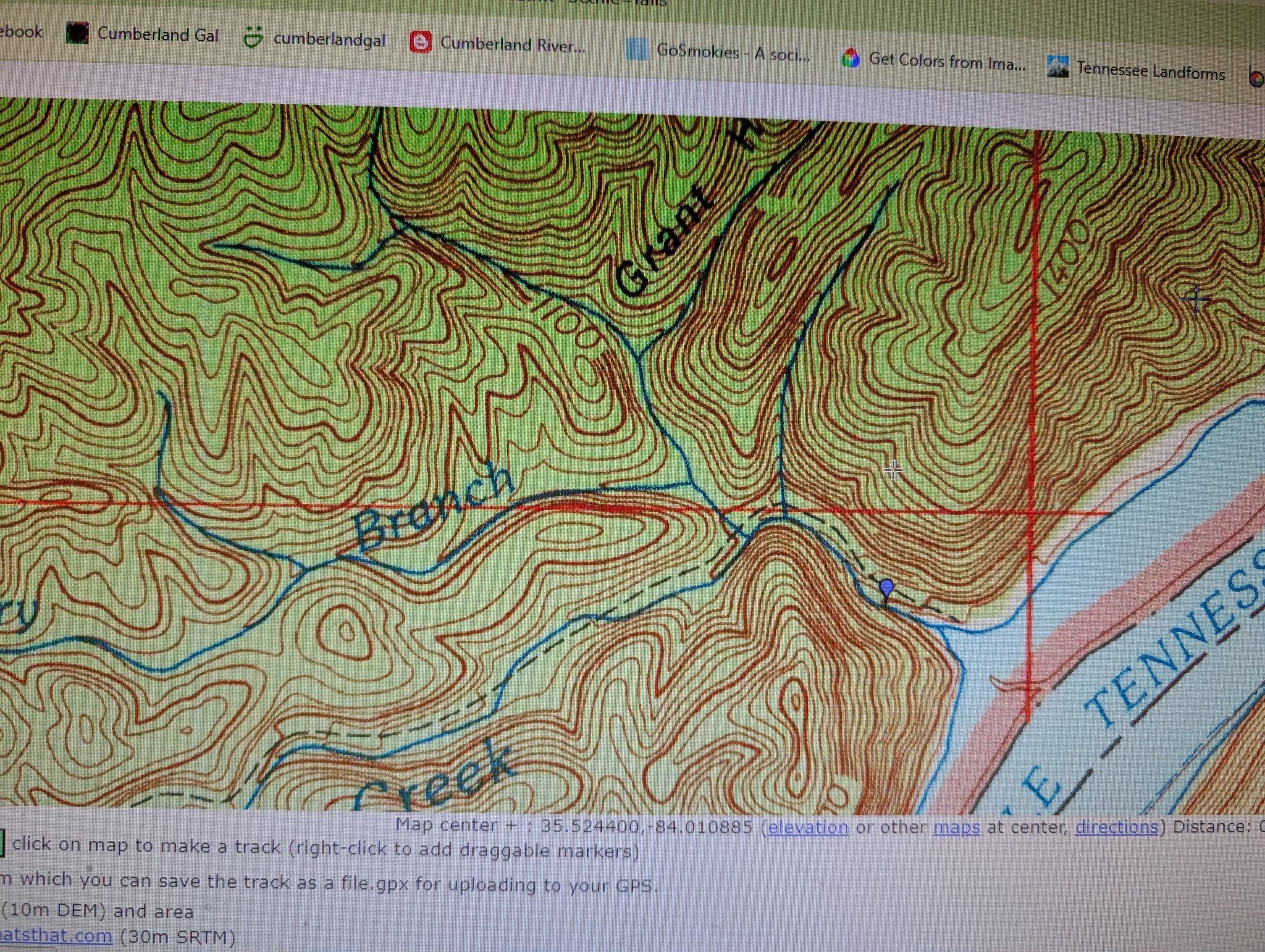
Below is an image of the Cal Topo map that shows the blue tear drop as Miry Branch Cascade. You can see the Little Tennessee River aka Chilhowee Lake.... and the dashed black line on the right of the stream headed southeast is the dirt road.
Below: another view of Miry Branch as we work our way upstream
Below : a view of the foggy forest canopy above this stream!
Below: Miry Branch Cascade waypoints for the falls are 35.522700,-84.010940
Below: the side of the cascade with Kenny in it for scale.
We climbed out and as soon as we stepped into the lake waters which were about 18 inches high we stepped into squishy mud and silt on the bottom. I headed toward what I could see was a sandy, rocky base for the stream and soon the squishing stopped. You never know how deep you're going to sink into that muck. The forest was turning a sallow color and leaves were falling. The air above the stream was foggy in the tree canopy.
\
We walked up the stream side and enjoyed the spectacle of the cascade. It was as pretty as I remembered. Again, the stream was not flowing as well as I'd hoped after all that rain. It was still worth a visit though. I'm just glad our drought conditions are passed.
I want to walk all the way up that old road sometime because I believe there are at least a few nice cascades up Carringer Branch. We didn't go too far upstream having been here before.
Plus at this point we had one more waterfall.. Nighway Branch we wanted to find. It was 0.30 miles further down the lake on the same side. We also wanted to motor on down to where we could SEE the power station at the hydroelectric tunnel. I don't think you can proceed further up the lake. For one thing the river becomes rocky and shallow. I think there may be some type of barrier as well.
Above and below: some smaller slides and cascades on Miry Branch
Above: blurry photo of some type goldenrod About all that was blooming
Below: a raised fire pit or cairn.
We climbed the bank and got onto the old dirt road to come back down to the shore.
Getting back in the boat wasn't bad. More walking in muck, but it was quickly over. I sat on the side of the boat and swished my feet around to rinse them off. Once we were back on board it was nice to sit down. I got a drink of water and was looking forward to heading to find Nighway Branch Cascade.
Kenny fired the motor up, but it would not trim. Meaning it wouldn't go back DOWN into the water where it would do us any good. He cut the engine. He fiddled and fiddled with it. Removed the engine cover. Tried all kinds of manuevers to lower it. I was having flash backs to paddling a pontoon boat across Center Hill lake with folding chairs and swimming to push it back across. I walked to the front and raised the seat and started getting oars out. The engine still refused to lower into the water.
Finally we were left with no alternative, but to paddle. Thankfully we had some nice long oars.
We had to first get the boat turned in the right direction. Kenny tried, but failed. I got him out of the way and pushed on the lake bottom until she began to turn outward. We were at last heading toward the road and the far shore. I was relieved I could see the Tabcat Bridge in the distance. Cars were streaming by every little bit. We knew if we could get over there we could pull it ashore, anchor it off, and probably get a lift back to the truck. We had a little less than a mile to paddle across.
We sat down on either side of the front of the boat and paddled. It slowly gained forward momentum and the Tabcat Bridge began to grow larger. We had resigned ourselves to this mode of transport.
It was aggravating, but funny too. We laughed and cut up. About halfway across to the bridge we heard a high pitched whine as the engine lowering mechanism engaged! It lowered itself into the water. Kenny jumped up and unplugged it so it wouldn't raise up again. I couldn't believe it. I'd been doing a piece of praying and the Good Lord heard! We were tickled to be able to use motorized travel again.
We put the idea of finding Nighway Branch Cascade on the back burner and got out of there while the getting was good! A few minutes later on the ride back to the ramp I looked at Kenny and laughed telling him I knew he was a shit magnet. He was the cause of the failure! He laughed at the joke.
He was a good sport. We made it back unharmed. I had sent a text message despite not having a phone signal. I also put a Facebook post out just in case. Once we got back I sent a second text to Adam, our son in law saying not to worry we were off the lake and fine. I was almost back to Walland when the phone rang and it was my bestie Sharon. She got the Facebook message and was checking on us! Love her heart. She was relieved when she learned we were safe. I was then able to take the post down.
Kenny learned a lesson and so did I. Raising the motor up too high can cause it to get hung in the up position. It is always good to keep a long handled screw driver along to reach in and engage the manual lowering device. He put one on the boat and tested it to see that it worked. He also set about doing some maintenance on the boat.
My friend John Quillen has a canoe that is an old school aluminum Grumman brand. He has a real dry sense of humor and named it the Steenhatchie after the river his mountain climbing partner Brian fishes in. It is located in Florida in the Big Bend region... right where Hurricane Helene hit. He and his buddies have turned the odd word "steinhatchie" into something that to them means the same thing as FUBARD (fouled up beyond all repair) I texted him to let him know what happened to us on our maiden voyage. I told him it was funny that we got steenhatchied. I said I needed to pick a name for the new boat. Contrary Bastage was one choice. Foo Bar was another. He was tickled and told me to feel free to use "Steenhatchie" if I wished since it behaved like that!
Below is a photo from John's blog that shows the USS Steenhatchie.
One of the things I've found lately is that when I get stuck for inspiration on places to go I need to stop struggling with it. Instead I go back and look at my "Wish List". I have been plugging in spots off my wish list instead of trying to revisit so many spots or force myself to come up with new ideas. It has been pretty satisfying and while it may not work perfectly every time it works!
I tried to figure what I wanted to do for my birthday this year. All plans felt forced and involved the entire day with the entire family. It had a LOT of moving parts. I thought better of it. Instead we kept it simple with the family. Sunday Kenny and I got out to do something just he and I. We would take the canoe out for the first time in a long while. The plan was paddle through the abandoned train tunnel on Calderwood and find Parsons Branch Falls. The back up plan was to swim over at Slickrock Creek in the cove. I got a new waterproof phone case for taking photos with my cell phone from my parents. It would provide me with an opportunity to test it out and learn about it.
Sunday morning I woke up feeling better. I had finally gotten a good nights sleep.
We packed our lunch and gear and set off. The Foothills Parkway was pretty. All along the Tail of the Dragon we saw yellow fringed orchids and black eyed susans and sunflowers. Good views.
Traffic was light. We arrived at Magazine Branch Boat ramp to find only one or two other cars.
One set of kayakers was leaving as we arrived. We saw two gentlemen fishing at the mouth of Slickrock Creek and that was it. Calderwood Lake was shimmering like a new dime. On the banks of the lake grew tall green-headed coneflowers, heal all, and sedges.
We launched the canoe easily today. We've learned a thing or two. Down the lake we proceeded. It was quiet, the air fresh and the water soothing and icy cold. While it is still Summer in these parts the trees are beginning to lose their bright green and show some browns and yellows in their leaves. We did not see any eagles today which was a tad disappointing.
We did see a couple herons, a hawk, and too many king fisher birds to count! The kingfishers swooped up and down the lake hunting and making racket.
above: Magazine Branch Boat Access where we set off
Below: the shimmering water of Calderwood Lake. It is very still right now. That was to change!
Above: Heading down the lake looking over the bow of the canoe
The ride down the lake was pretty, but somewhat uneventful. Considering some of the trips we have taken in kayaks that was alright. The first thing we passed was the cove for Slickrock Creek. The plan was to hit that on the return trip for swimming. We kept a sharp watch out for the campsites on the left side. I knew or believed CS #2 was supposed to be just before and diagonal from the tunnel. I was running the GPS with my "Best Guess" coordinates plugged in for the tunnel. We both knew that it had to pass through a point of land jutting out from the right side of the lake. We were nearing my coordinates and just such a point of land. I could see what I believed was the tunnel. At first I was unsure if it was just a dark spot or actually the tunnel. Our position shifted slightly and I could tell that was it! I could see the light shining through it. We headed in that direction. We could see a mist coming forth from the tunnel's eastern entrance.
Below: We are approaching the tunnel's eastern end. See the mist lingering at the top right of the photo? That is really how the scene looked.
Above and below: Once we got close enough to the entrance we could judge we weren't going to be able to paddle through it today. The lake level was too high and we were riding too high in the water.
Below is a photo looking through the tunnel. The lake is far more shallow here with lots of submerged rocks. It was an interesting and pretty spot despite not getting to go through today.
We will have to return and try again in Autumn when the water levels are pulled down. It is always a pretty trip. I tried to talk myself into swimming through it, but I just couldn't muster the courage. I would want a head lamp and an inner tube or something. I was worried about what was submerged there as well as snakes. Kenny pointed out that while the distance was rather short the space was very tight and if you saw something in there you didn't have much room to react or get out fast. Exactly my thoughts on the matter. Not today son!
Below is a video of the tunnel:
We went round and took a look at the western end of it. It was also rather neat, but not quite as picturesque as the eastern end. We kept going down the lake. We hadn't gone far when we passed Tunnel Branch which empties into the lake and has a cascade on it. We could see it, but it was piddly today. Not much to look at.
We were getting tired of sitting in the canoe with our legs bent. We ached to get out and stretch. We started looking earnestly for a spot where we could do that. We didn't have to go far until we came to another cove where a stream flowed into the lake. It was also a bit lack luster on the flow, but an attractive and safe spot to get out to stretch. We decided to have lunch here. It was perfect. A stretch and lunch and a chance to experiment with my waterproof phone case and taking pictures.
Click the link just before this for a short clip of video shot with my waterproof phone case.
Below is a photo of the spot we stopped for lunch.
We were happy to have got out of the canoe, but didn't linger too long here at our lunch spot. We set off once more toward Parsons Branch to find the falls. I had no idea what locating this would be like. I believed it would be far shorter to reach from the lake than from the road.
We pushed onward to the west until we spotted a large cove on the right. We both knew this had to be Parsons Branch. The GPS coordinates bore that out. We approached and began to have doubts about accessing this cove because of many submerged logs. It ended up being no problem. We were riding high enough in the water to slide right into the cove. We were able to paddle up and beach the canoe easily. We could hear water gushing strongly. More than any of the other coves we'd passed where streams flowed down. I knew Parsons Branch took in the flow from Dalton Branch and one more un-named tributary prior to emptying into the lake.
The rocky shoal where we got out was a little muddy, but it wasn't deep, sticky mud.
We were able to easily wade up the stream toward the first cascades and pools. It was a beautiful spot. Upon walking up the approach went up the left side facing upstream. I saw twenty or more cranefly orchids in bloom.
Below is a photo of a close view of a cranefly orchid.
Below is another image that shows the growth habit of the orchids.
They can be hard to spot in shade or dappled light.
We followed the path upstream and there was another surprise for us. We had no idea this spot was a fourth campsite! It sure was. I don't know that I'd want to stay there. It was cramped and would be for use with a tiny tent only. It was a beautiful spot though with a good swimming hole. It had a tent pad, fire ring, lantern post, and picnic table made of trex.
Above is a photo of the campsite. You can't see the tent pad as it is up the bank from the table.
I was just so happy to be out. I was taking pictures and lollygaging. I had a lot of missed outdoor time to make up for. Kenny was just strolling around taking his time too. He did not rush me. He yelled out for me to cross the creek that he had found the falls. It was right up ahead. It has a nice plunge pool that is a fair swimming hole. It has lots of submerged rocks as I was to find out. It wouldn't be a place to dive as it isn't deep enough. Add to that the submerged rocks just below the surface. It was a beautiful sight and I just soaked it all in. Finally I got in the pool and swam up to the falls. It was cold and crisp mountain water. It smelled good.
It felt great on my skin. I worked my way across with the Go Pro in its waterproof case.
It turned out to be one of those waterfalls that isn't bad to try to climb. It has velvet green moss at the base that even when wet has some grip like a carpet! I was able to climb right into the falls.
Kenny cheered for me, but then went quiet. Not to be so easily outdone he kept looking and found a land route to the falls! There was a trail leading straight to it on the right.
He laughed because he avoided getting in the cold water. I admit it is just like me to make things harder than they have to be, but I was having fun so I did not care. He was happy to see me out and doing my thing. Getting back to my old self after all these months of health and mobility challenges. I could feel myself absorbing all the negative ions from the falls and the soothing sounds and sights of nature.
Above: approaching the cove for Parsons Branch
Above: the rock formations above the falls were very cool. Lots of swirl holes in there!
Above: Looking at the spot where the falls goes through a chute to the pool below.
Below: Parsons Branch Falls
Above: I swam from here to the falls and climbed up.
Below: Rocky shoals where we beached the canoe and walked up.
Below: a look at the first pool we encountered upon landing.
Below: looking down the chute at the pool
Above: a small, pretty cascade at the mouth of the stream
We climbed above and around the waterfall to survey it more. It was very neat. It is not a huge waterfall at around 15 feet high, but it was quite pretty. It reminded me of Upper Meigs Falls. It is worth mentioning that there is a road bed above the camp site leading to the falls and beyond. It also heads right toward Dalton Branch. I believe this may be the tail end of the Dalton Branch Manway. I would be interested to know if the old road leads up to Hwy 129? Kenny believes it must. Having looked down the drainage from the road I will say it is possible, but I saw no evidence of it from up there. The only way to tell would be to attempt to come down from the road or follow it up.
Cardinal flowers and monkey flowers bloomed along the creek. It was a bluebird day for certain. We were thrilled to have found both the tunnel and the falls! We finally walked back down the old road toward the campsite and onward to the canoe. It wasn't long until we were heading back up the lake on our return trip. I wanted to stop and swim at Slickrock Creek.
Kenny was stressing a little about time. He had to leave town the next day for a couple weeks for work. He was worried about having time to get ready and also time to rest a little. We ended up skipping Slickrock Creek. Bummer.
I pointed out on the way back that the water was far more choppy. The current was a lot stronger. It occurred to me why this was: The power company was releasing water at Santeetlah dam no doubt. The lake level had risen by two feet or more. The wind was up also.
Between the current and the wind we passed spots on the lake where ribbons of gold and rust leaves would accumulate. They spanned the lake from shore to shore. It was pretty and a hint of the coming of Fall. I always love this time of year.
We made it back to the boat ramp. One good thing that came of the higher water levels was that we were above all that slimy "seaweed" anchored to the lake bottom. The water remained sparkling clear despite the higher levels.
We got the canoe and gear packed up and hit the road for home. It was a beautiful drive without a lot of traffic today. We were grateful for that. The next day was my birthday and it was a good thing we had fun the previous day because my actual birthday was NOT fun! Instead it was filled with challenges.
Below is a video of the highlights of visiting Parsons Branch Falls. It was more than worth the trip.
We had been wanting to get out and spend time with our other two grandkids Michael age 10 and Tessa age 5. Now that Gabriel was with his parents more we took the opportunity to give our daughter and son in law a date night. We kept our two grandkids overnight and had them all day Saturday. We set out to do a couple easy hikes with them in the Robbinsville , NC area.
We first visited Twentymile Cascade and Moore Branch Cascade. These are in the Great Smoky Mountains National Park on the North Carolina side. You have to drive the Tail of the Dragon to get there. It was actually not bad for a Saturday. Plenty traffic, but a little more courteous today than the usual. Everyone did well on the curvy road and no one got car sick.
Twentymile Cascade is a very short hike and super easy over a mainly flat trail. The only elevation gain is the tad bit on the part toward the falls. Michael had to have a potty break in the woods so while Kenny went ahead with Tessa I hung back with him to watch for other hikers approaching.
I noticed that dropping into Moore Branch at the bridge is another stream with a waterfall on it. I had never paid attention to it before in all the times I've hiked there. It is heavily overgrown with rhodo.
We got going again and in a few seconds were on the descending trail to Twentymile Cascade.
It was flowing so strongly there was no way to safely get close to it today. In times of normal flow you can climb down the rocks and onto the shoal below the falls. Not happening today. The kids were not thrilled with any falls they had to stay back from. They like to be IN the scene!
Most of the Spring wildflowers were done for the season, but we saw a few things. I saw Prester John... a five leaf form of Jack in the pulpit. Only the second time ever for me seeing this.
Michael our grandson. Tessa and Pawpaw up ahead. Some random fisherman guy.
Catesbys Trillium
Dwarf Crested Iris
Twentymile Cascade above and below
Grandson Michael and Papaw Kenny
Above and below: Prester John.. note the five leaves
Above and below: Different angles of Moore Branch cascade. a low but scenic spot on Moore Branch.
We wrapped up the somewhat disappointing hike to Twentymile Cascades. The kids wanted to go somewhere they could get right in the creek and wade. We made it back to the jeep and got a snack and kept going. We would stop in Robbinsville on the way through and grab some lunch. We ate fast food at Wendy's and felt better. Nanny made everyone go try a bathroom break even if they didn't feel like they needed to go. Kids peeing in the woods especially girls.. can be a hassle. If a number two or three comes along Heaven Help us!
Once we were done with lunch and back in the jeep we left Robbinsville heading toward Burgan Creek. It is a little known, little visited waterfall in the Nantahala Game lands. It is a pretty waterfall and not a real long hike. We had successfully visited it once before in Winter. I had wanted to get back to see it in warm weather. I believed it would be even prettier and that it would be a good wildflower destination. It is not a very long hike, but it turned out to be a little harder than I recalled. I was tickled that Kenny and I both remembered the road directions to the trailhead. I did not worry about that until it was too late, and we were already on the way.
It was a nonsense. We found it easily. If you pass the shooting range on the right of the road you have gone too far. We parked at the forest service gate and began our hike.
It goes along an old logging road for a short distance. It then turns and goes right and begins a climb on a true trail. It is flagged very well the entire distance to the falls. There is more than one creek crossing, but the first one is "bridged" by a board. We climbed through a rhododendron tunnel for a fair distance. We passed a seepage spring that Tessa wanted to go investigate. We came to the top of the ridge and someone had put a rock cairn to make the trail. We had a little huffing and puffing on the climb, but not too much. We then went down the short distance to the stream. We crossed and on the other side we went back up again for a little. The trail stays on creek right for most of the way. I'd say the first half of the trek after the crossing. We came to a point where we had to ford the stream again. It was not bad. It was running pretty good, but could still be rock hopped. We helped the kids across. They did great.
We stayed on creek left until the very last and we crossed one final time to approach the falls with the stream on our right. The entire forest was a nice wildflower destination. The Spring ephemerals were on their last gasp though. Need to do this hike in earlier Spring.
above: Tessa and Papaw looking at the falls
We got to the falls and we were all treated to a glorious view of the falls. They were surrounded by blue sky, green trees, lush vegetation and mossy bluffs. We stopped to take it all in. We spent a fair amount of time playing in the creek and enjoying the scenery. The kids liked it much better since they could get in this stream. Tessa was getting tired and was about over the hiking and we still had to get her back to the jeep! Kenny headed back with her a bit ahead of me and Michael. We lingered and played in the creek more and explored.
I am glad they like outdoors. I wonder if hiking is going to be Tessa's cup of tea? Too soon to say, but so far she is not a big fan. She may be my shopping and junking buddy instead. She loves that stuff.
above: Burgan Creek Falls in late Spring.
Below: Burgan Creek cascades through mossy logs and rocks. You can barely see Kenny and the kids down below the falls.
Below: Grandson Michael really likes hiking and is playing in the creek.
Below: Pretty cascade just in front of where Michael played in the stream.
Below: an representative portion of the trail we hiked. It is very brushy and a little hard to follow if you were new to this. I guess it isn't fair to judge whether Tessa is going to like hiking based on this. She is not a fan of any trip where grass and weeds brush her legs.
Above: Michael shows a flat stone he found in the stream
Purple wake robin trillium
White wakerobin trillium. These were a few wildflowers still blooming on the hike.
Lots of blue cohosh and toothwort and Canada violets too.
We headed back and joined Tessa and Kenny at one of the stream crossings. They had rested and we all got along easier on the hike out. We decided based on Tessa's fatigue level we'd not press our luck. I do not ever want to turn a hike into a misery trip for my grandchildren. I don't want them to learn to hate it. We had been going to try Yellow Creek Falls another short one, but that will wait for another time.
We began the drive home and I asked Kenny if he minded for us to take a quick side trip. I wanted to see if Gladdens Creek Falls really was along the side of the road toward the Skyway. We didn't have to go far .. maybe quarter to half mile before we saw a pull out along the left of the road. Room enough to park about six cars. A beautiful stream cascaded down toward Santeetlah Lake. It DID exist! The tourism map that showed it was not lying. It probably isn't worth a stop during drier times, but today was it ever! It had more sweet shrub growing round it than anywhere I've seen.
We ended our day on a positive note. The kids spent the night with us Saturday since that was mom and dad's date night. We took them to church in the morning and handed them off afterwards.
What a great weekend of outdoor recreation and quality family time. Tessa told me "Nanny, I want to do something again with you and Papaw, but NOT hiking!" 😄
Below are a couple short videos of Burgan Creek Falls and Gladdens Creek Falls. First-- Burgan Creek Falls