(cued up to the first picture in this series click right arrow to advance)
Kenny is still going strong on this job site he is tied to. It will be coming to a close in about a week or ten days, but I had another Saturday to occupy myself. I thought about what I wanted to get into. I decided I wanted to try going to Gobey all by myself. I wanted the quiet and beauty I would find there. I wanted to prove to myself I could do it alone. I could get an idea how the bloom was progressing.
I could see the pretty green waters of the Emory River again. I had reviewed some bookmarked material and photos on the computer. I realized we had missed Mahan Village completely. I knew it was there, but it still had a building left and we missed it. Once I saw that it was settled in my mind. I reviewed the map as to the position where Mahan Village should be and got waypoints ready. I prepped my gear and laid it all out. Next morning I packed up the jeep and headed out to Morgan County. The drive is an easy one with pretty scenery most of the way.
I had thought I was going to hunt up a missed bridge in Wartburg, but decided to save that for later in the day if I still felt like doing it. I arrived at the turn for Gobey to see a whole lot of folks preparing to take off riding in RZR's. I pulled over at the first bridge to take photos of the river. They passed me flying down the road. I noticed that I was way early for flowers as I suspected. The areas I was seeing were brown, dead, and not one green thing popping up.
Above: The Emory River was indeed green today, but instead of being the beautiful green or blue-green it was milky green. We'd had a lot of rain the previous day so no surprise there the water would be turbid.
I continued out the road and went through the expected moment of self doubt "Am I going the right way?". said my internal monologue. A moment or so more and I began to see familiar houses and the confusion and doubt cleared up.
I stopped to take a photo of my favorite red barn. It is an odd shape, but there are not one.. but two of these in the area.
Below is the pretty red barn with the airplane hangar design!
It was a bluebird day with pretty clear skies, sunshine, and cool temperatures.
I had a nice breeze. I was enjoying seeing daffodils all along the road. The rural scenery alone is worth the drive out here in any season. I soon came to an old cabin up on the slope above me. Someone has really cleaned this abandoned home site up and got it looking better. A garage of new construction was just over from this cabin.
Below: log cabin sitting above the main road.
I proceeded up the road and soon arrived at the first gate which is Sang Branch. I wanted to go across to see the old stone walls, and check for wildflowers on the opposite side of the river in the sandy soil. I was able to ford the river here without any difficulty and didn't even end up with any water in the floorboards.
I stopped as soon as I was across and pulled over to the side out of the way.
I took time to walk up the trail and explore. Forsythia shrubs were blooming all around. Mainly they were on the opposite side of the branch. I did not go over there to look, but from all appearances I am betting it was a home site. The stone walls next to the stream were covered in furry green moss. I saw lots of trout lilies up and in bud, but not open yet. I saw lots of toothwort and a few sprouted daffodil leaves. The stream itself was running well and was nice and clear.
Above: mass of forsythia blooms against a blue sky. You can se the mossy stone wall in the background. Beyond this was likely a house.
Below: beautiful Sang Branch flows down the mountain to join the Emory River.
Below: a look out across the field at the long, long rock wall next to the stream!
Above: Sang Branch spills into the Emory River
Above: first sweet betsy trillium of 2021!
Above: bloodroot opening up by the stream.
I continued my journey by fording back to the main road and going upstream toward the next gates. They begin #1 Sang Branch and go up to #5 ending with Emory River Headwaters out near the site of a former coal plant.
Below is a video of Sang Branch today
Next I turned aside to one of the many roads on the left. It had a pretty creek flowing down along it. I wanted to explore to see what I'd find. I did not find much, but did get out and stroll along the creek bank enjoying the woods and the few wildflowers I saw. They are still very early up here. I saw toothwort, trout lilies in tight bud, and a few long spurred violets. The stream itself was spectacularly clear. I loved the sound of it as it flowed over rocks and tiny cascades.
Below: a look at the creek and how clear the waters were!
Below is a look at some toothwort
And below a pretty Confederate violet
I returned to the main road and went on up toward the north western end for it eventually dead ends for vehicle travel. A rough four wheeler trail continues and can take you out to Devonia if you know how to follow it. I've never been all the way through there. I'm not sure Kenny has either. I stopped off next at Macedonia Church. I got out to walk around and stretch my legs. I was getting hungry so I enjoyed the sunny spot to have my sandwich and something cold to drink. I walked down to check out the crosses by the church and the view upstream of the river.
Below is a short video of this sparkly stream
Above: Macedonia Church
Above: three wooden crosses by the church. Perfect here at Easter time!
Above: Looking upstream on the Emory River behind Macedonia church. I noticed how the river is looking muddy and murky the further up I went.
Next I continued and came to a huge quince bush by the road which was in full flower. It was so pretty. I stopped to check this out and get some photos. Behind me was a nice view of the mountains to the northwest.
Above: the pretty view of the sky and the mountains
Below: biggest quince bush I ever saw!
Below: a closer look at the coral colored blooms with their bright yellow centers. Quince is a fruiting shrub. Quince was planted as ornamentation for yards back in the day and almost always means there was a house at a spot where you see these. The fruit also makes a nice tart jelly which I like!
I had been counting gates and knew I should be getting close to gate #4 and Rayder Branch which is near the site of the old Mahan Village. It was a thriving community at one time. Gobey is now a ghost town compared to its former glory days of the lumber and coal industry. Now there are far less people living in the area. You find a lot of gas wells in the vicinity.
I did not try to ford the stream at gates 3 or 4. Not much across there I wanted to see plus the stream bank drops off steeply. I was trying to be somewhat careful as I had no phone signal, and was a long way from help if I got stuck. Just past the gate for Rayder Branch I ran upon what I'd been looking for... Mahan Village! It sits immediately by the road in easy view! The only thing left is a set of bridge supports and one old building which was the former company store. I could not explain how we managed to miss this on previous trips? The area had been freshly cleared of excess brush and weeds around the old structure. It almost had to be buried heavily beneath vegetation. I was careful where I drove since the bush hog activity had left sharp pongee sticks protruding from the ground. I walked back through the field to check out the bridge supports where the railroad crossed Rayder Branch. I inspected the old store building. It is a mess of broken glass.
Above: old store building in clear view of the road
Below: a look inside revealed tons of broken glass
Below: the door is gone and the block wall is damaged.
Below: the far end of the company store building is also blown out. if the front looked anything like this when we were here before no wonder we missed it!
Below: one of two bridge supports just this side of Rayder Branch
Next I continued toward the end of the road and my turn around spot. This section is not as pretty or interesting in my experience or opinion. Gate #5 was shut today which did not matter to me. I walked over to look for wildflowers. I found a few. The creek up here was like the Platte River out west. in Nebraska.... Too thick to drink.. to thin to plow.
Below: a look upstream revealed the Emory River Headwaters to be murky, muddy brown!
Below is a look at the bridge that crosses the Emory River at Gate #5
Below: rue anemone blooms in this area
Below: another Sweet Betsy trillium
I stopped here and lingered awhile enjoying the quiet. I finished up my lunch.
I then reversed course and headed back. I stopped off by a few of the side roads to the left to explore, but did not find much. It was fun running through the mud and splashing. My jeep handled great.
I stopped by an old chimney at a former homesite to get some photos.
I got to see the old tater hole, the chimney, lots of pioneer junk including the coils from a mattress, old tin cans, glass jars and bottles, corrugated tin from a roof, and the former sidewalk and steps! The daffodils bloomed all around this pretty spot. It must have been something to see back in the day.
Above: a mossy set of steps where the house used to stand. Daffodils in full bloom. Wonder how long ago they were planted? My guess would be the 1930s.
Above: old brick chimney of the house ruins
Below: tater hole that was beneath part of the old house
Lastly at the house ruins... there is a pretty spring branch that flows down the hill. I am betting this was their water source.
Just past the old house site and chimney... was a narrow, rough gravel pull off that goes down to the river. It is a very pretty spot. I took a chance and pulled the jeep down there. It just barely had room enough to go on the trail, but it handled the rocky, loose dirt just fine. I had neither trouble going down nor coming up out of there. It surprises me how much traction and torque that little machine has. I got my jeep turned around after a 17 point turn technique in the tight space. I wanted to be heading the right direction in case anyone else pulled down here. I needn't have worried. I saw very few vehicles all day. I gathered my camera gear and walked down to the river to take pictures and shoot video footage.
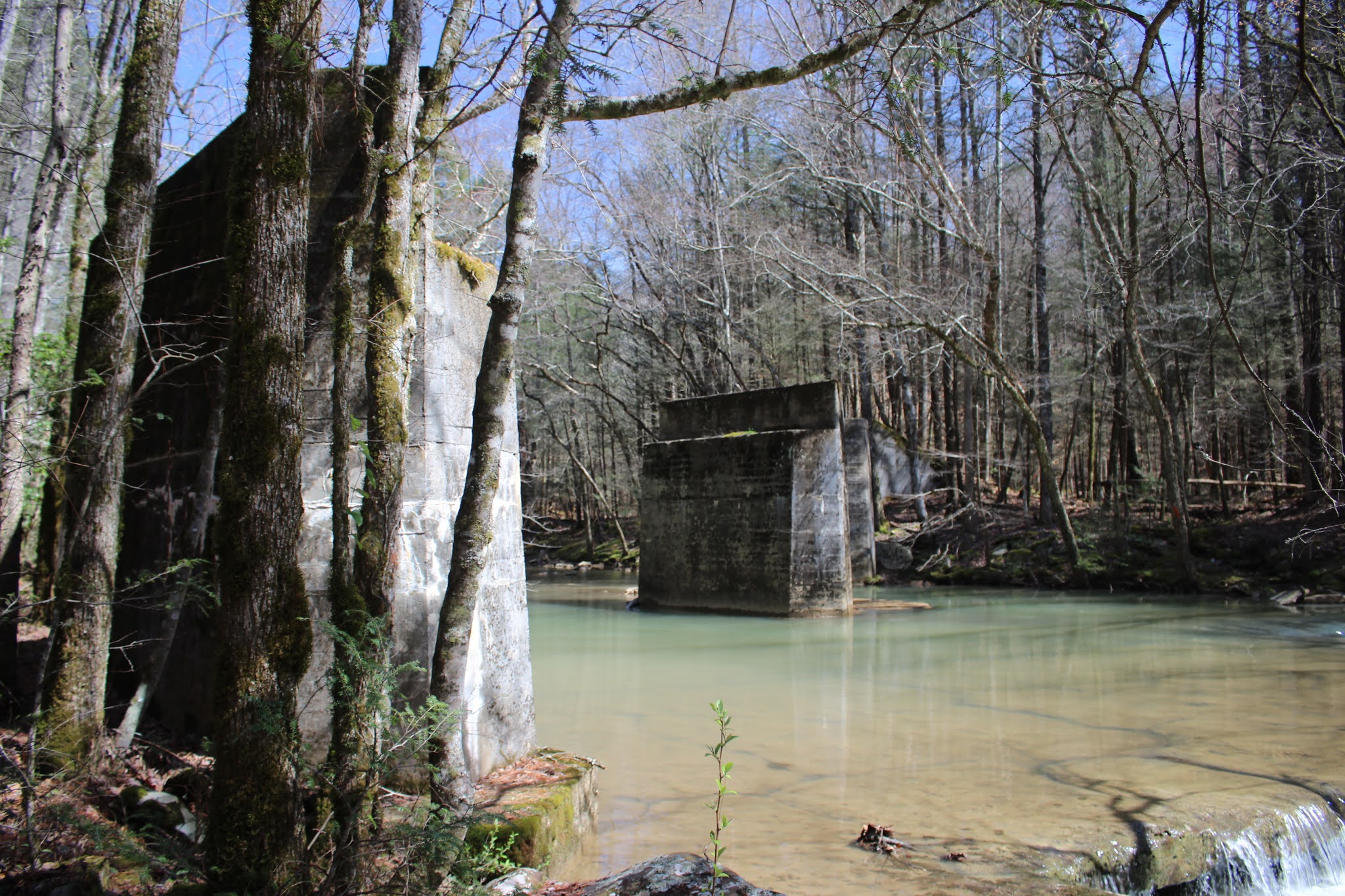
The Emory River is pretty and blue here sometimes. Today it was milky green , but still pretty. A low, wide cascade crosses the stream here. Just below that are a set of bridge supports from the former Emory River Lumber Company railroad.
If you go on down past that there is a nice fishing hole in the bend of the river.
Above; pretty cascade across the Emory River
Above: Looking downstream at the bridge supports .
Below is a nice video of the cascade
I did not stick around here today as much as I thought I would. The river was milky looking. No wildflowers were in bloom. I was a tad bit concerned wondering if my jeep was going to come up out of that hole? It bit in and went up out of there just fine. I was getting a little tired and thought I'd just head home, but I passed a spot where I could see another cascade and a second set of old bridge supports. I couldn't stand it so I pulled over. I'm glad I did. I walked out the former railbed to the end where what is left of the old bridge stands.
Below: former railbed is flat as a fritter going straight out through the forest. The sides are built up and gently sloping. Once at the end there is a faint path off the side and down to the stream.
Above and below: a couple sidelong glances at the bridge and cascade
Below: there is nothing like standing by these old bridge abutments to help you realize how large they truly are
I wanted to get a different photo and video of this spot than I had previously.
I took a look around and found a spot downstream where the river split in two around a gravel bar. It was a much shorter, shallower spot to ford the stream.
I picked my way across quick and careful and only ended up with a slightly damp heel. I was able to position myself to get some good images.
Above: the river down here at this spot was far prettier than anywhere else today. It was cleaner and clearer. I hope to have a chance to return to see flowers as they emerge and catch the river looking its best!
Below is another look at the supports on the far side of the stream
And below is a last shot of the beautifully colored and textured pebbles in the stream near the gravel bar.
I concluded my day with a leisurely drive back through the rural setting of farms, houses, old buildings, and pretty Spring flowers in yards. I stopped off in Oliver Springs briefly to get half dozen items I needed so I did not have to go in the grocery store proper. I wanted to get home because Gabriel, our grandson and my granddog Tippy.... his pup were coming to spend the night. We planned to go to church the next day. Gabe was not happy with me when he found out where I'd been. I confessed to him and Kenny that I got confused on which road to the left lead up to the waterfalls we found last year. This was the only thing that got me out of hot water with Gabe. He knows now that he must return with me and Papaw to show me which way to go. All in all it was a very nice day and so relaxing.
I missed Kenny, but we will try to make time for a return trip and a picnic.
Final photo is a picture of Gabe & Tippy when they woke up on Monday. Two cuties! We had so much fun playing.
Gabriel age 4 and Tippy age 1. Up and getting ready for preschool. This is his room at our house.
Below is a video of the last spot in the river where I stopped and waded out.
Above: some sort of insulator with porcelain insert and metal housing. Not sure what it was from. It was laying along the bank of Little North Mouse Creek across from the Cleage house half buried in mud.
Address is : Highway 11, 1163 North, Athens, TN 37303
Waypoint is 35.490141, -84.57979
Cleage Cemetery is located at 35.482684,-84.593630
I am very interested in history. I am interested in old buildings and abandoned places. I am thrilled with a spooky story that can give me the shivers. I'm not a believer in ghosts. I'm a skeptic, but I've had friends who told me stories that are unexplainable and I believe them. I am not at all a fan of gory, bloody, slasher films or what I call 'booger movies" like The Walking Dead and its Zombie Apocktaclipse. I hate all that mess. I figure over the years at work I have filled my head up with enough negative and scary.
I got to reading Amanda Gamble's stories and histories. Checking out her documentation of the Samuel Cleage house. I wanted to see it for myself. I had a list of stuff I wanted to see and do in the Athens vicinity. It was a back burner project. We had a death in the family when Lydia's sweet sister, Liz passed away unexpectedly a couple weeks ago.
I was upset over it. I was down and all the plans I'd had just did not matter anymore. I was crying off and on all day and not sleeping the best. I got up Saturday morning and kind of moped around. Kenny finally said "You can't let this destroy you. You need to get out of the house for a little while. Think of something.. anything you want to do for a couple hours and we need to go get your mind off this." I knew he was right. I browsed through my lists and ideas and finally the only thing that struck me as interesting was a drive to Athens.
I told him I wanted to go down there and see the Cleage House. I knew where it was. I knew that it had long sat abandoned, but had more recently been turned into a haunted attraction. I wrongly thought that it was an operation that ran only during the Halloween season. Oh no... it runs year round. I'm not a big fan of that sort of thing anyhow, but I knew that as raw as my nerves were I was in no condition to put up with something like that. I figured that would be the last straw for me. So I had to settle for getting some shots of the house from outside.
It was not a very satisfactory experience. They have modified this historic home in ways that are unappealing and to me inappropriate. I kept telling myself that I should be grateful the old place was still standing and being given a second chance at life. I might not love the next incarnation of it, but it has helped it survive. The Cleage house is now known as The Scream Chamber.
Here is a little bit of the history of the man and his family as I have been able to gather from various sources.
Above: photo of the Cleage house in its current incarnation as The Scream Chamber. Of course all the advertising logos and that big long, black wooden part were built on by the new outfit. Including the wooden steps on the side.
Above: another view of the Cleage house and from this angle you can see the "Flemish Gables" the highlighted circle at the top left corner of the photo.... on the roof of the house illustrates how the gable end extends past the roof line. It seems to be like that on both ends.
Samuel Cleage was born Pennsylvania and moved around to Botetourt County, Virginia. He moved to Tennessee in the years 1823-1825. I have found two differing accounts. He was a businessman, brick mason, and contractor. He arrived in Tennessee around age 42 and brought with him his family. The moved to the area around Athens and settled on a farm. It was land that had been seized by the government from the Cherokees. He was a slave holder and moved them with him to Tennessee. It seems from what I've read he treated his slaves pretty well. He educated them in masonry and most of them took the Cleage name willingly because of his fair treatment. I did read that once many of his slaves obtained freedom they did not cut ties with the family, but remained close. To this day many of them still trace their lineage back to the man and his family. I highly object to the whole slavery thing, but I have to remind myself it was a different time. I can't change it. By the time he would have moved around forty plus years of age I expect his children were possibly even adults and may have begun families of their own back in those times.
It was a long trip to make back then by road especially with all those people and animals and furnishings, equipment to tote along. It appears he was an itinerant worker along the way. Building houses and such as he made his way down south from Virginia. They not only had to build the houses by hand of brick, but MAKE the brick! It is no telling how long the trip actually took. I'm guessing a couple years. Depending upon the route chosen the trip would be either longer or shorter. It could have been as short as 340 miles or as long as 370 miles.
The house he constructed on the "Mouse Creek Farm" parcel he bought which ended up being around 3000 acres of ceded land, was a fine looking brick home. He was a master mason and it had all kinds of special architectural touches not usually seen. He used Flemish bonding which I have learned means that alternating bricks have their short sides showing. You can check out the photo below as an example of this. I imagine it was stronger than most typical brick construction. The type house he built was popular at the time with more well to do persons. It is an old Federal style house. It also has "Flemish Gables" which are the gables that extend above the main structure of the house or roof for aesthetics.
He must have been quite talented as the house still stands to this day, and while aging is basically sound.
Above: an enlarged photo trimmed out of the house image. It illustrates the Flemish bond of the brick. Alternating short bricks with lengthwise ones. Pretty and strong!
I am considering what drew him to Tennessee? I am betting it was the newly acquired large tracts of land that the government wanted resettled by whites. I have read varying reports over how much land he owned exactly. I read 1800 acres, then I read 3000 acres. I sat down with the deeds and added it all up and came up with 4, 044 acres of land all told. I expect that the amount of Tennessee red clay soil was a draw also. It would have been excellent for brick making. Tennessee also has lots of sandstone and sand was needed in brick making. It was used as a sort of flour or no stick agent when molding bricks. You know when you make biscuits or rolls a baker will flour the dough to be able to handle it? Brick making from clay was done sort of like this. The sand was like the flour in order to be able to handle the clay and form it into bricks in molds without having it adhere to the mold!
Above: When we pulled over on the side of the road for me to photograph the house in the distance... I looked to my right and saw this very decayed old bridge. It crosses Little North Mouse Creek to what would have been the remainder of the Cleage Farm. From a satellite view you can see the ruins of a barn, two silos and several sheds buried within the trees and weeds.
I walked down the embankment to get a closer look at it.
Here is a view down the creek from the bridge. It is rather pretty.
Above: a better look at the bridge from the stream bank. The under pinning and frame is metal and still pretty sound!
Above: I could look across the creek and see this one building in the weeds. I could see the tops of the silos , but that was it.
Samuel Cleage was married to Mary Stanback Cleage. Together they had three children Alexander, David, and Sarah. He became a very wealthy, successful man with a nice family. Today some say the Cleage house is haunted. It turned out that Samuel Cleage was murdered and died there in the house. He got into some sort of disagreement between himself and a man named Ambrose Griffith. No one to this day knows the exact nature of the argument, but it escalated to the point Griffith stabbed Mr. Cleage. On July 17, 1850 he was stabbed by Griffith. He was taken to the house and tended and lingered. aware of his condition and likely demise. He was a good man and forgave his killer before his passing. I cannot even imagine the horror.
He passed away on July 20, 1850 upon hearing this Mr. Griffith fled the area. Far as I know he was never seen or heard from again. I do not think he was ever punished for his crimes. Samuel Cleage, his wife, his children, and some of the slaves are interred in the Cleage Cemetery out along Mt. Verd Road in Athens, TN.
I visited and found it with the help of Mark Gilreath who is a friend who lives and works in the area. At the time of my visit I found the cemetery in rather poor repair, but someone had visited and had marked graves. Even burials with no visible memorial stone. They probably went by the depressions in the ground of which I found plenty. I am estimating there were around 20 burials in that cemetery that I was able to discern by the flags, stones or depressions in the ground. There could easily be more.
Another reason why folks say the place is haunted is because one of the slave women split a man's head open with a meat cleaver. It was a Union soldier back during the Civil War. The tale was told of a Union soldier bursting into the house suddenly. Food raids were common in those times because people were starving. He saw nothing valuable so instead he spat into the freshly baked pan of Mamie's cornbread which was all the family had to eat. She was enraged and split his head open upon the spot killing him. I have read one horrible but brief account of an infant being killed by a crazed nanny in the Cleage house, but I cannot verify that by another source. All the tales above have been confirmed from two sources.
I am not a believer in ghosts, but then I've never seen one. I will watch spooky things on t.v. and be like "Oh Lord! that is so scary! I bet I won't be able to sleep tonight!" Later that night I'll catch myself getting up to pee or get a drink of water in the kitchen with no lights on. I will think back to the day and what I saw on tv and I laugh like crazy. I am too dense to see ghosts I imagine. I must be too dumb to get scared. Long as the ghost would let me sleep I'd not care. Just let me go back to bed and let me alone. Anyone or anything messing with my sleep is apt to cause a fight.
I will update this entry if and when I get to tour Cleage House on March 27th.
Below are some photos of the graves in the Cleage Cemetery.
It is interesting to note that the McMinn County Historical Society is kept busy periodically assisting people to find out more about this interesting family. Many of the relatives come seeking info from all around. That is a fine legacy just by itself not to mention the many stout, attractive buildings in Tennessee and Virginia that owe their existence to Cleage and Crutchfield Construction!
It pleases me especially to know that the slaves who trace their family history back to him have descendants who come looking just the same and still have a bond with this family.
Below: another infant burial only around six weeks old. Poor little thing.
This with the flag, the slight depression in the ground and the stone is a burial, but I don't know who.
Above: wrought iron enclosure at the beginning of the cemetery. all it surrounds is two trees. I am guess it was protection for newly planted trees and ornamental as well.
Above: Jacob Malone marker.
Above: Cassius Smithson another infant burial 7 months old.
Above: the Samuel and Mary Cleage monument was the largest in the cemetery.
I could not make out the writing on this headstone.
Periwinkle beginning to bloom in the cemetery.
I have learned from my reading that a new friend, Dennis Stewart, a talented and dedicated historian in the area is responsible for the Cleage Cemetery being in as good a condition as it is! Many thanks for the upkeep of this remarkable historic site.
Again I will add information to this blog and repost it if I get additional relevant material.
For now I leave you with a peaceful scene of emerging Spring along Little North Mouse Creek. It has been a crazy and rough year, but you have to take those little snippets of beauty and solace where you can find them.
Scroll to the very bottom of the page for a map and directions to Cleage Cemetery which is not easy to spot if you don't know it is there.
Below: the google map of the location of Cleage Cemetery with the spot marked.
Directions to Cleage Cemetery from Cleage House aka The Scream Chamber:
From Scream Chamber along Hwy 11 head south for 1 mile and turn RIGHT onto Mt. Verd Road (Road #305) Drive 0.10 miles on Mt. Verd Road and turn RIGHT into a driveway to a multiplex apartment building just past Subway.
It goes to a round parking lot for the apartments. Pull to the far end of the circle and watch on your right--same side as the apartment building for a faint path leading into the clump of trees. This is Cleage Cemetery. In Winter or early Spring when the trees are not leafed out you will be able to see the tops of grave monuments from the parking area. I would not do this in Summer as it is very snaky and weedy. During any other season just go, but be careful. The ground is full of depressions from sunken graves and footstones that are hard to see thanks to the snarl of grass. Someone has placed survey flags at the known burials. Please be respectful to the deceased, mindful how you'd feel if it were your relatives burial place.
Also do not litter or be disruptive to the folks living in the apartments.