

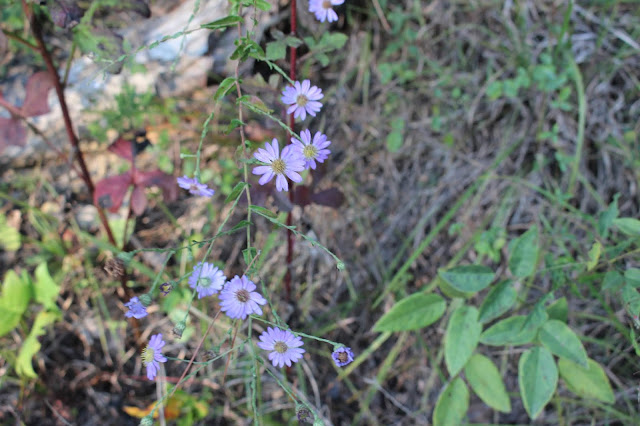
Purple Morning Glory growing at Maple Hill Campground
Maple Hill Camping Trip & Hiking With Friends
Kenny & Dana Koogler
John Ungerer and Sharon McGee
Friday Sept. 20 through Sunday Sept. 22, 2018
As promised--Directions to the Land Features out Darrow Ridge Road
 Two views of Darrow Ridge Road.. above it is sandy and dry. Below it is a deep mud hole.
Both can get you. The sand can cause you to lose traction as well. Kenny didn't know this. I learned as a kid riding on the beach sand with my parents what can happen! You learn to stay on the damp sand and let some of the air out of your tires for better grip!

Friday
We finally got a chance to go camping just as a couple and visit with friends.
We stayed at Maple Hill and it was a good weekend. We got to spend time as a couple and that was much needed. We also got to catch up a little with Sharon and John. We arrived about 10:30 a.m.
and got set up. I went for a walk around the campground and took some photos of the late Summer/early Autumn wildflowers. It was so nice to see the first Fall colors creeping in.
I saw a butterfly chrysalis on my walk. When I was a kid I often had praying mantis nests in shoe boxes in my room or a monarch chrysalis waiting to see them hatch. One of the cedar trees was festooned with the most fox grapes I've ever seen! They were almost black they were such a deep purple. Kenny did not know what fox grapes were. They are tiny wild grapes that are very sour.
Remember the old Aesop's Fable about the fox and the sour grapes? There you go.. Fox Grapes!
Southern states like Tennessee also have muscadines which are another type of sweet, large wild grape. They grow in Virginia, but the climate there is a on the cold side for them.
Below: Cedar tree with fox grape vines thick in its branches!


Above: first bright red leaves of the season..

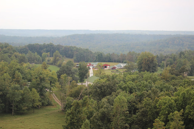
Above: Maple Hill Campground viewed from the walking path. The river birch in front of me is shaking off its Autumn leaves. The sky has a steely gray overcast today, but the temperatures are marvelous. Seventy five degrees with a light breeze. Perfect hiking weather!
We got set up and called John & Sharon to let them know we had arrived. We rode out to the house to see them, and come up with a plan for the weekend. After visiting a bit and discussing our
agenda of places to visit it was decided they'd sit out today, but join us tomorrow. Since it was just
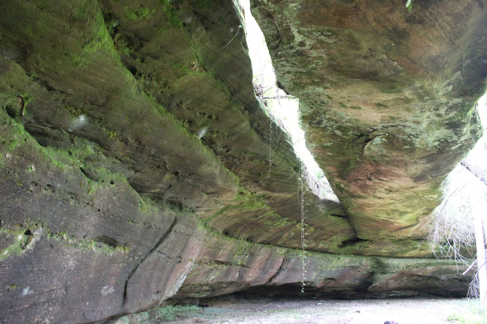
us today we headed off to hike to some of the land forms out Darrow Ridge Road. We missed the turn for the road and went way past it. It had been just long enough we took for granted we'd be able to find it easily. We were wrong. We just were not paying enough attention. Since we'd bypassed it we decided to hike to Sunset Overlook instead. We have hiked to East Rim Overlook, and Devils Cave, but never this little overlook. It was a short, easy hike on a trail so we knew it would be simple. I also wanted to get a glimpse of the Big South Fork from the Leatherwood Ford bridge because there is a waterfall off trail back there! A fellow hiker has a YouTube channel called Smell N Roses . I really enjoy his adventures, and I take a lot of inspiration from him. It's my favorite. I watched his Bandy Creek Falls video. It was so beautiful it moved that hike up onto my short list. Here is a link to that video so you can decide for yourself, but it looks like fun to me. Bandy Creek Falls Bushwhack by Smell N Roses. I see in my crystal ball of the future......... a bushwhack to visit this spot in person!
We parked and walked across the road to Sunset Overlook Trail. It is a 1.3 mile one way
hike and rated easy. I found that accurate. The forest had a spicy smell of the coming Autumn although the leaves were not colorful yet. They are still in that green fading to brown or yellow phase. I don't care. I like the Tweener Season too. The field in front of the parking area
was one big swath of goldenrod. We had passed fields on the drive out with tall stands of purple
New York Ironweed mingled with bold wands of goldenrod. Tiny mushrooms peeped out of the grass at the trailhead.
 Sign at the trailhead for Sunset Overlook
 Signage in front of the truck. The field has been mowed, but the goldenrod is still thick! Lots of good hiking right here from this hub.
We were the only ones at the trailhead when we arrived. It was a Friday afternoon during the school year so it did not surprise us to have the place to ourselves. The trail guide stated that
the hike too you past old farm ponds and over streams. Despite the rainy weather the streams did not exist today. They were dried up which left the trail less muddy. The first of the farm ponds was
not that interesting. It was hard to see through the weeds, but what we could see was mostly green pond scum and dying vegetation. The second farm pond was an intriguing place! Frogs croaked and hopped. The water was dotted with little green lily pads. If you look close you can see tiny bright yellow specks on the water. These are bladderwort blooms! They are carnivorous aquatic plants! They supplement their diet by catching and eating gnats, mosquitoes, and no-see-ums!
They are our friends for sure! A huge gray crane flew from the far side of the pond! His wings swooshed as he took off. We heard the calls and songs of many different types of birds. Dragonflies zizzed past like tiny bi-planes. Late Summer wildflowers like great blue lobelia, goldenrod, queen anne's lace, white and purple asters dotted the dam where the trail crosses. We stood for a time on the hike in just enjoying the quiet and the sounds of nature.

 View of Big South Fork of the Cumberland River as seen from Sunset Overlook
 Some form of blazing star in bloom at the overlook. It is that time of year!
We arrived at the overlook and for a couple minutes had the place to ourselves. We heard people and another couple showed up. They were very nice. They had their dog with them. We talked with them a bit and they left just ahead of us. We soaked up the scenery at the overlook. The view was not as wonderful as all that since the day was so overcast. Below is a short video of the overlook.
We stayed at Maple Hill and it was a good weekend. We got to spend time as a couple and that was much needed. We also got to catch up a little with Sharon and John. We arrived about 10:30 a.m.
and got set up. I went for a walk around the campground and took some photos of the late Summer/early Autumn wildflowers. It was so nice to see the first Fall colors creeping in.
I saw a butterfly chrysalis on my walk. When I was a kid I often had praying mantis nests in shoe boxes in my room or a monarch chrysalis waiting to see them hatch. One of the cedar trees was festooned with the most fox grapes I've ever seen! They were almost black they were such a deep purple. Kenny did not know what fox grapes were. They are tiny wild grapes that are very sour.
Remember the old Aesop's Fable about the fox and the sour grapes? There you go.. Fox Grapes!
Southern states like Tennessee also have muscadines which are another type of sweet, large wild grape. They grow in Virginia, but the climate there is a on the cold side for them.
Below: Cedar tree with fox grape vines thick in its branches!
Above: first bright red leaves of the season..
Above: Maple Hill Campground viewed from the walking path. The river birch in front of me is shaking off its Autumn leaves. The sky has a steely gray overcast today, but the temperatures are marvelous. Seventy five degrees with a light breeze. Perfect hiking weather!
We got set up and called John & Sharon to let them know we had arrived. We rode out to the house to see them, and come up with a plan for the weekend. After visiting a bit and discussing our
agenda of places to visit it was decided they'd sit out today, but join us tomorrow. Since it was just
us today we headed off to hike to some of the land forms out Darrow Ridge Road. We missed the turn for the road and went way past it. It had been just long enough we took for granted we'd be able to find it easily. We were wrong. We just were not paying enough attention. Since we'd bypassed it we decided to hike to Sunset Overlook instead. We have hiked to East Rim Overlook, and Devils Cave, but never this little overlook. It was a short, easy hike on a trail so we knew it would be simple. I also wanted to get a glimpse of the Big South Fork from the Leatherwood Ford bridge because there is a waterfall off trail back there! A fellow hiker has a YouTube channel called Smell N Roses . I really enjoy his adventures, and I take a lot of inspiration from him. It's my favorite. I watched his Bandy Creek Falls video. It was so beautiful it moved that hike up onto my short list. Here is a link to that video so you can decide for yourself, but it looks like fun to me. Bandy Creek Falls Bushwhack by Smell N Roses. I see in my crystal ball of the future......... a bushwhack to visit this spot in person!
We parked and walked across the road to Sunset Overlook Trail. It is a 1.3 mile one way
hike and rated easy. I found that accurate. The forest had a spicy smell of the coming Autumn although the leaves were not colorful yet. They are still in that green fading to brown or yellow phase. I don't care. I like the Tweener Season too. The field in front of the parking area
was one big swath of goldenrod. We had passed fields on the drive out with tall stands of purple
New York Ironweed mingled with bold wands of goldenrod. Tiny mushrooms peeped out of the grass at the trailhead.


We were the only ones at the trailhead when we arrived. It was a Friday afternoon during the school year so it did not surprise us to have the place to ourselves. The trail guide stated that
the hike too you past old farm ponds and over streams. Despite the rainy weather the streams did not exist today. They were dried up which left the trail less muddy. The first of the farm ponds was
not that interesting. It was hard to see through the weeds, but what we could see was mostly green pond scum and dying vegetation. The second farm pond was an intriguing place! Frogs croaked and hopped. The water was dotted with little green lily pads. If you look close you can see tiny bright yellow specks on the water. These are bladderwort blooms! They are carnivorous aquatic plants! They supplement their diet by catching and eating gnats, mosquitoes, and no-see-ums!
They are our friends for sure! A huge gray crane flew from the far side of the pond! His wings swooshed as he took off. We heard the calls and songs of many different types of birds. Dragonflies zizzed past like tiny bi-planes. Late Summer wildflowers like great blue lobelia, goldenrod, queen anne's lace, white and purple asters dotted the dam where the trail crosses. We stood for a time on the hike in just enjoying the quiet and the sounds of nature.

Spiral ladies tresses -- one of our native orchids along the trail


We arrived at the overlook and for a couple minutes had the place to ourselves. We heard people and another couple showed up. They were very nice. They had their dog with them. We talked with them a bit and they left just ahead of us. We soaked up the scenery at the overlook. The view was not as wonderful as all that since the day was so overcast. Below is a short video of the overlook.
We moved on and the only variation on the hike back was that we turned and tried hiking out the road to the truck. Kenny thought we might get more of a breeze, but it turned out not to help. We were hot thanks to the still air and humidity! We spoke to the other couple and told them goodbye as we both parted ways.
Next we doubled back looking sharper this time for Darrow Ridge Road. We'd at least get in
one other hike today. I had seen a photo of Fiddler's Arch on Tennessee Landforms and wanted to visit it. It looked nice. I will list the various features out that road and try to post some directions to them. Now a word of caution and explanation about Darrow Ridge Road itself. It is an odd road.
It starts out coming off Highway 154 as paved and continues through a residential area. Once it
reaches Timber Ridge Horse Campground it deteriorates down to dirt. During wet times it can be
a muddy mess that you could sink down to your axles in a vehicle. The road veers out into a field which is not easy going and very bumpy. It still has muddy spots, but not as bad as the bare dirt road.
You parallel the road for a good ways and then the two come back together. The road isn't done with you yet if you follow it all the way to its end. It changes to gravel, pavement, dirt. It
is one of the weirdest messes I've ever seen. We have traveled it before in the truck and had to turn around due to the mud. If you go pick a drier time or go prepared with a four wheel drive vehicle or on horseback.

Both can get you. The sand can cause you to lose traction as well. Kenny didn't know this. I learned as a kid riding on the beach sand with my parents what can happen! You learn to stay on the damp sand and let some of the air out of your tires for better grip!

I plugged in the GPS coordinates for Fiddlers Arch. Four land forms exist out this road. #1 Wildcat Den is 1/2 mile hike and signed. on a trail. #2 Hippy Cave 0.2 miles one way hike and signed. on a trail.
#3 Fiddlers Arch.. 0.2 miles one way hike and unsigned. with a trail. #4 Christian Tunnel 0.25 miles one way and unsigned completely off trail. I felt like I knew about where to look for the trail to Fiddler's Arch, but the GPS unit will show you if you have passed it. I spotted it easily and we were able to pull over and hike out to it. There is plenty place to pull over and park. The hike is easy.
It is not signed until you are almost on top the arch. Once there and you need to start downhill you'll look up and see a sign ARCH ~~> on a tree. From the parking area you'll pass through a brushy spot , and emerge on another dirt track that parallels the road you were on. I think that may be Darrow Ridge Horse Trail. You stay straight and cross this and go through more brush. I am used to doing this so it did not bother me. Once at the arch Kenny spotted a snake. He swore it was a copperhead. On the return hike I was more leery since I was just waiting to get bitten. He has told me before some snake was a copperhead and it was a northern water snake.
 Fiddlers Arch above and below. Different angles to show it off in better light. Virginia Creeper vine was hanging down between the parts of the arch from up top!
 We arrived at Fiddler's Arch and it was very pretty and well worth the short walk to it.
It is 45 x 10 and sits down in a hole. It was pretty with the evening sun starting to shine down in there. After Kenny's snake hollering I did not venture out into the weeds and vines around the arch. I stayed where I could see my feet and what was around me. I was pleased to finally get to visit another feature out this old road. The hike back and drive out were uneventful. We splashed through a mud hole, but made it out! I enjoyed the view across the ridge and the meadow full of goldenrod, purple asters, golden wingstem, white asters and white crownbeard. We were filthy dirty and smelly so we headed back to the camper to get a shower before forcing ourselves to go to
Wal-Mart in town and do our grocery shopping. Ugh. Once we got done we headed home to fix supper and rest. We were tired. The next day was calling for rain, but we were planning short, easy stuff so we hoped for the best.
Below is a short video of it.
 Above: native sunflowers of some type blooming along the ridge road
Above: Purple asters are one of the signs of approaching Fall for me. Also along Darrow Ridge
Drown Mes. I watched dragonflies dart about and got buzzed a couple times by a humming bird.
A king fisher bird flew past. I could see minnows in the stream. It was quiet, calm and tranquil.
Here is a link to the video Peters Bridge Access .
 Above is a photo of Peters Bridge at Clear Fork
While I was glad to finally see this area for myself, there wasn't much to it today. We did not tarry long. We headed toward Burrville Tower. I had seen the YouTube video by a fellow named Chris Covert of the fire tower. It hadn't even been a blip on my radar screen until I watched that! He hasn't been uploading videos lately, but I wish he would because the ones he had were interesting. Maybe he'll get back to it someday. We saw on Google maps that the lookout tower was immediately across from the Burrville Post Office on Fire Tower Road. Upon arriving in Burrville there is no longer a post office in the spot shown. Unless it is in the abandoned trailer home or the red shack by the road. ;^D We followed Fire Tower Road a short distance up to a cow pasture. I had to get out and open the gate to let Kenny drive through. If you go.. close the gate behind you as their are cows in the meadow. The tower was easy to find and was in good condition. It was cool to finally visit a tower where the cab was not locked! You can climb right into the cab and look around. I think his video stated that it gets used now and then as a fire lookout even now. That may be true as it is still
wired for electricity and a phone line. I'd say the last time it was called upon was a couple years ago during the drought. We went to Jamestown and passed Crab Orchard Mountain which was on fire at the time!
 Above: the Burrville Lookout Tower. It is a tall one!
 View to the east and the lovely Cumberland Plateau

It is not signed until you are almost on top the arch. Once there and you need to start downhill you'll look up and see a sign ARCH ~~> on a tree. From the parking area you'll pass through a brushy spot , and emerge on another dirt track that parallels the road you were on. I think that may be Darrow Ridge Horse Trail. You stay straight and cross this and go through more brush. I am used to doing this so it did not bother me. Once at the arch Kenny spotted a snake. He swore it was a copperhead. On the return hike I was more leery since I was just waiting to get bitten. He has told me before some snake was a copperhead and it was a northern water snake.

It is 45 x 10 and sits down in a hole. It was pretty with the evening sun starting to shine down in there. After Kenny's snake hollering I did not venture out into the weeds and vines around the arch. I stayed where I could see my feet and what was around me. I was pleased to finally get to visit another feature out this old road. The hike back and drive out were uneventful. We splashed through a mud hole, but made it out! I enjoyed the view across the ridge and the meadow full of goldenrod, purple asters, golden wingstem, white asters and white crownbeard. We were filthy dirty and smelly so we headed back to the camper to get a shower before forcing ourselves to go to
Wal-Mart in town and do our grocery shopping. Ugh. Once we got done we headed home to fix supper and rest. We were tired. The next day was calling for rain, but we were planning short, easy stuff so we hoped for the best.
Below is a short video of it.


Saturday
Saturday morning dawned overcast, but some sun peeping through the clouds. Sharon is getting a late start these days because of some health and sleep problems. We got up at 7:30 a.m. and fixed pancakes and bacon for breakfast. We decided to go visit Peters Bridge access and the Burrville Lookout Tower out past Allardt. Both these things I'd wanted to see for awhile. We didn't have any trouble locating them and the ride was fairly short. We stopped off at Peters Bridge access to Clear Fork. It is a popular access for boaters and kayakers. Today it was all but deserted. We were the only ones there until a young woman popped up with her cell phone and sat down at one of the picnic tables. I took time observing the stream and the river banks. There are picnic tables, a vault toilet, trash receptacles, a boat ramp, and a rope swing here to enjoy. The water levels today would making boating unpleasant to impossible. No one likes Drag Its, but those are better for us thanDrown Mes. I watched dragonflies dart about and got buzzed a couple times by a humming bird.
A king fisher bird flew past. I could see minnows in the stream. It was quiet, calm and tranquil.
Here is a link to the video Peters Bridge Access .

While I was glad to finally see this area for myself, there wasn't much to it today. We did not tarry long. We headed toward Burrville Tower. I had seen the YouTube video by a fellow named Chris Covert of the fire tower. It hadn't even been a blip on my radar screen until I watched that! He hasn't been uploading videos lately, but I wish he would because the ones he had were interesting. Maybe he'll get back to it someday. We saw on Google maps that the lookout tower was immediately across from the Burrville Post Office on Fire Tower Road. Upon arriving in Burrville there is no longer a post office in the spot shown. Unless it is in the abandoned trailer home or the red shack by the road. ;^D We followed Fire Tower Road a short distance up to a cow pasture. I had to get out and open the gate to let Kenny drive through. If you go.. close the gate behind you as their are cows in the meadow. The tower was easy to find and was in good condition. It was cool to finally visit a tower where the cab was not locked! You can climb right into the cab and look around. I think his video stated that it gets used now and then as a fire lookout even now. That may be true as it is still
wired for electricity and a phone line. I'd say the last time it was called upon was a couple years ago during the drought. We went to Jamestown and passed Crab Orchard Mountain which was on fire at the time!


Above: View from the Burrville Tower to the south. You can see the little community of Burrville
in the distance. Below is a zoomed in view of the town. It looks like a post card.

We enjoyed climbing the tower and the marvelous view from up top. The only bad part was the bird poop all over everything. We made sure when we left that the windows and door hatch were all securely closed. How the birds got in is anyone's guess.
We got back to the camper and grabbed our gear to head over to Woo Hoo Holler to meet John & Sharon. We got our bearings and decided to car pool. Our agenda for today was as follows:
- The Steel Coop Restaurant in Livingston for lunch
- Ice cream for dessert at The Lazy Cow Creamery
- Garrett's Mill Falls and Cave
- The Roaring River Boils
- Tally Creek Tunnel
- Flynn's Creek Crater
We got to ride in John's pretty pick up truck. They let me ride shotgun so I would not get carsick on those winding roads. I've been known to do that and be dog mud sick the rest of the day.
John is an excellent driver and handles the curvy roads like a boss! We got to Livingston and were all hungry. The Steel Coop is a new dining place so it was great to get to try it. You can click the link to check out their Facebook Page. It was a good meal and a relaxed atmosphere. Service couldn't have been better. The place is clean as a pin and the owners have thought of every nicety.
Restrooms are immaculate and they provide not only a changing table for parents, but diapers, crayons and coloring paper, and feminine products for emergencies. Now that I am a mom again
and dealing with diaper changes....... I appreciate these things more than ever!
I had Autumn vegetable soup and a house salad. That way I saved room for dessert. The icecream at The Lazy Cow Creamery was good! Check out their Twitter page for information. I had a single scoop of dark chocolate and while it was very good I could not finish it all. Too rich! I like sweet, but I find in my old age I am losing my taste for much of it. It's worth mentioning as a Note to Self
that Livingston has a nice play park and splash pad in the downtown! I had no idea. Be fun to bring
the grandkids here.
We headed out of Livingston toward Garrett's Mill Falls & Cave. We were on a do-over trip today since John missed the first visit. We found it with only one slight wrong turn that was quickly corrected. The land is marked for sale which may mean loss of access to this pretty place. Glad we came on when we did. It was drizzling rain, but we didn't let that stop us. The water flowing out of the cave was a stronger stream that last time! I figured the falls might not be as good today, but boy I was wrong! They were flowing even better than in Spring. As I approached the cave walking in the creek I heard a loud crash to my left. I looked up to see a tree fall on the slope above. We walked up to the cave and climbed in. I had a headlamp, but it was so dark that it didn't help. Kenny came on with a stronger light and we explored the cave a bit. Some vandals have spray painted graffiti in the cave. We didn't see much litter but the graffiti was bad enough. The cave is interesting, but the rocks in the stream are sharp and slick! We got to the cave mouth and the rain poured down in buckets. Leaves fell from the trees. It was a beautiful scene. Today is September 21st. The official first day of Fall. It has arrived! The fog in front of the cave was very mysterious and really made it special. Below is a video of us standing around talking in the cave while the rain pours down and so do the leaves!


Above: The fog over the stream is amazing!
Below: The cascades in front of the cave entrance. The stream spreads out far and wide here flowing down to form two or three falls below.


We walked down to where the stream drops off forming the waterfall. Kenny and Sharon glimpsed it, but did not want to wade out into the dripping weeds and brush to get a better look. John and I just went ahead. It really blessed me to see how much John liked it and to know we'd succeeded in bringing him back to visit. Both he and Sharon felt like it was a place distinctive enough they could certainly find it again should they want to return. I wandered around taking photos of the various scenes at the falls. I enjoyed the white water and deep velvety green moss.
The late Summer wildflowers here were quite a spectacle themselves! I found the mother lode of all
Grass of Parnassus. It is a somewhat rare wildflower. I've seen it before in a few places, but never like this! It went on and on. It was mingled in with both white and pink turtleheads, great blue lobelia, and bright orange spotted jewelweed. I also saw hearts a bustin. Those are the little red pods in Fall.


Hearts a bustin flower

Great Blue Lobelia

Garrett's Mill Falls in profile from the left. I liked this angle too.
Below: a pretty spot where the moss and water mingle at the edge of the falls. I was able to just cross the creek and walk out on the opposite side. I have decided Garrett's Mill Falls is one of my all time favorite places to visit. I would like to come back alone and just spend lots of time exploring here. I have a feeling there is more to find in the way of history, wildflowers, and who knows what else. The vibe here is very peaceful and positive to me. Nearby are the ruins of an old grist mill in the woods. I did not take many photos of that today. It is easier to see in Winter or early Spring when some of the leaves are off the trees.

We got back in John's truck and crept along when it was time to leave. They kindly stopped the truck for me to get out and photograph some of the wildflowers. They were splendid, but I would liked to have more time to study them and photograph them to their best advantage.


Closeup of Grass of Parnassus. It likes wet places and this spot certainly is!
Below is a video of Garrett's Mill Cave & Falls
We mosied on further west toward Jackson County and Gainesboro to visit Roaring River Boils.
The Boils are public land. They are actually a WMA property along Roaring River. Spring Creek goes subterranean and apparently the water resurfaces under pressure here in Roaring River. I could not believe we'd never taken time to visit this spot. It was not as impressive as I'd imagined today.
The video I saw of it by Chuck Sutherland showed the water really boiling big time. Today it was not doing as much. You could see it bubble, but very mildly. The gray skies here and the return of the rain did not do much to give this place a positive vibe. Sharon said she felt like this river was spooky. Too many submerged logs and stuff to suit her. The flooding experienced over here in times past has been tragic and terrifying.


Above: Rocky beach area at The Boils. .this is Roaring River under gray skies.
Here is a link to a super short video clip of The Boils
The rain started up again and the wind picked up. I asked everyone what they felt we should do?
Bag the trip and call it a day or continue on a bit? Everyone said let's go do at least one more thing.
Tally Creek Tunnel was nearby so we figured we could at least get that done. By now we'd all pretty much decided Flynn's Creek Crater was further than we wanted to drive today. It would have to wait for another time. It took us a bit to get oriented and figure which way to go, but we finally did and headed back toward the so called Tally Creek Tunnel. I had asked Chuck if he knew anything about it and he responded he wasn't sure that it was even there. He believed there was a structure in Kentucky that might fit that description. I was curious about it for sure. Prior to coming over I did some further searching and just called it Tally Creek CAVE.. not tunnel. That brought up a few sources with waypoints that matched what I'd found on Tennessee Landforms. No photos of it at all found anywhere. I bet that it was there, but nothing too special. Turns out I was right!
We drove along and Kenny helped navigate and monitored the GPS unit. I plugged in the
TomTom and between the two we found it. The waypoint is actually for the nearest place where you can pull over to park and walk to the tunnel. You can see it about forty feet away across the road.
The spot is a pull over for boat access to Roaring River. We walked over to the "tunnel" which was a non qualifying cave. It is way small. It does indeed form a sort of tunnel. It goes in one bank of Tally Creek and comes out facing the road on the far side. It may be 40 feet long. It has man made door frames installed but no doors on either end. More graffiti tags in it and around it of course.
I was tickled to have found it and gotten to be the first person I knew of to photograph it. Such as it was! Now at least there are photos on TN landforms so you can decide for yourself if it is worth the visit. I'd not drive over here just for that alone, but the area is pretty and has lots of other cool stuff to visit. Surely the right combination of short trips would make it worthwhile.


Inside the tunnel itself.
When we came out of the tunnel we headed toward Gainesboro at John's suggestion to see the quaint little town. It sits on a hill and is a pretty spot, but lots of typical abandoned buildings.
A shame. Maybe some day this will change for the better. The Cumberland River and Roaring River meet here in Gainesboro. It is one of those towns along the old river barge line!
Below is a short video of Tally Creek Tunnel
The rain set in for good for the evening. Our drive home seemed long. We were all tired and ready to be done for the day. Back at John & Sharon's home we enjoyed a wonderful meal of pork roast and veggies and hot bread. Sharon also made the best caprese I've ever had! I could have made a meal on just that! We had plenty of time to visit with one another and lots of good conversation. It was nice to get to be adults and take time to care for valued friendships.
Sunday
Sunday called for more rain all day. The weather forecast called for a couple hour window of dry in the morning. Kenny wanted to take advantage of that to pack things up. The new camper has slide outs and you want it to be dry when you bring those in lest you have water flowing off the tops of them into the camper's interior. John and Sharon said they'd come by Sunday to see the new camper before we shoved off for home. We were able to sleep in a bit and be lazy which is a luxury not afforded by kids. We had breakfast and Kenny started picking up outside while I tidied up inside.John and Sharon did make it by to visit for a bit. It was good to see them and we hated to go. It would have been nice to have an extra day especially if the weather cleared up. We are already looking forward to the next trip over to see them. Maple Hill is a great home base to choose.
It is convenient to many things. We have decided to take the grandkids to the Allardt Great Pumpkin Festival Saturday Oct. 6, 2018.
Below is a photo of something I'd been looking for a couple years and finally got to see it.
It is the sign of the Chi Ro carved into rock. It is at one of the land features we visited this trip.
It is not known how long this has been where it is nor who put it there. It is a sign formed by superimposing the first two letters of the Greek name for Christ.. Christos. Chi and Ro in such a way they form this symbol. I will not give out the location implicitly and ruin your ponder. If you are interested in finding and seeing intriguing things like this you'll have to work for it a bit. I will say that it is not easy to spot unless you are looking for it.

No comments:
Post a Comment
Thanks for reading and commenting. I enjoy hearing from those who read & make use of my blog. I have made some wonderful friendships through emails from readers. I respond to all comments and emails. I appreciate folks reaching out to let me know when my blog entries are not functioning correctly or if the situation somewhere has changed. Many Blessings to you!
Dana 🐝