
 Aster growing along East Fork River

Labor Day Weekend 2023--Woo Hoo Holler & Big South Fork
Kenny & Dana Koogler
Sharon McGee
Labor Day Weekend Friday Sept. 1 through Monday Sept. 4, 2023
Woo Hoo Holler Pix Here
Big South Fork Pix Here
Day 1 Saturday River Trail & Swimming
We went to spend Labor Day weekend with friend Sharon McGee over in Jamestown.
It had been a long time between visits. Too long. I would find out over the course of the weekend just how much too long it was. We got there Friday evening after Kenny's work. We had a nice supper prepared by Sharon. She doesn't like to cook so she says, but she is quite a good cook.
It was so good to see my buddy and hug her. We sat up gabbing and planning for the next day.
Saturday morning after breakfast we gathered our stuff, and went out riding on the four seater.
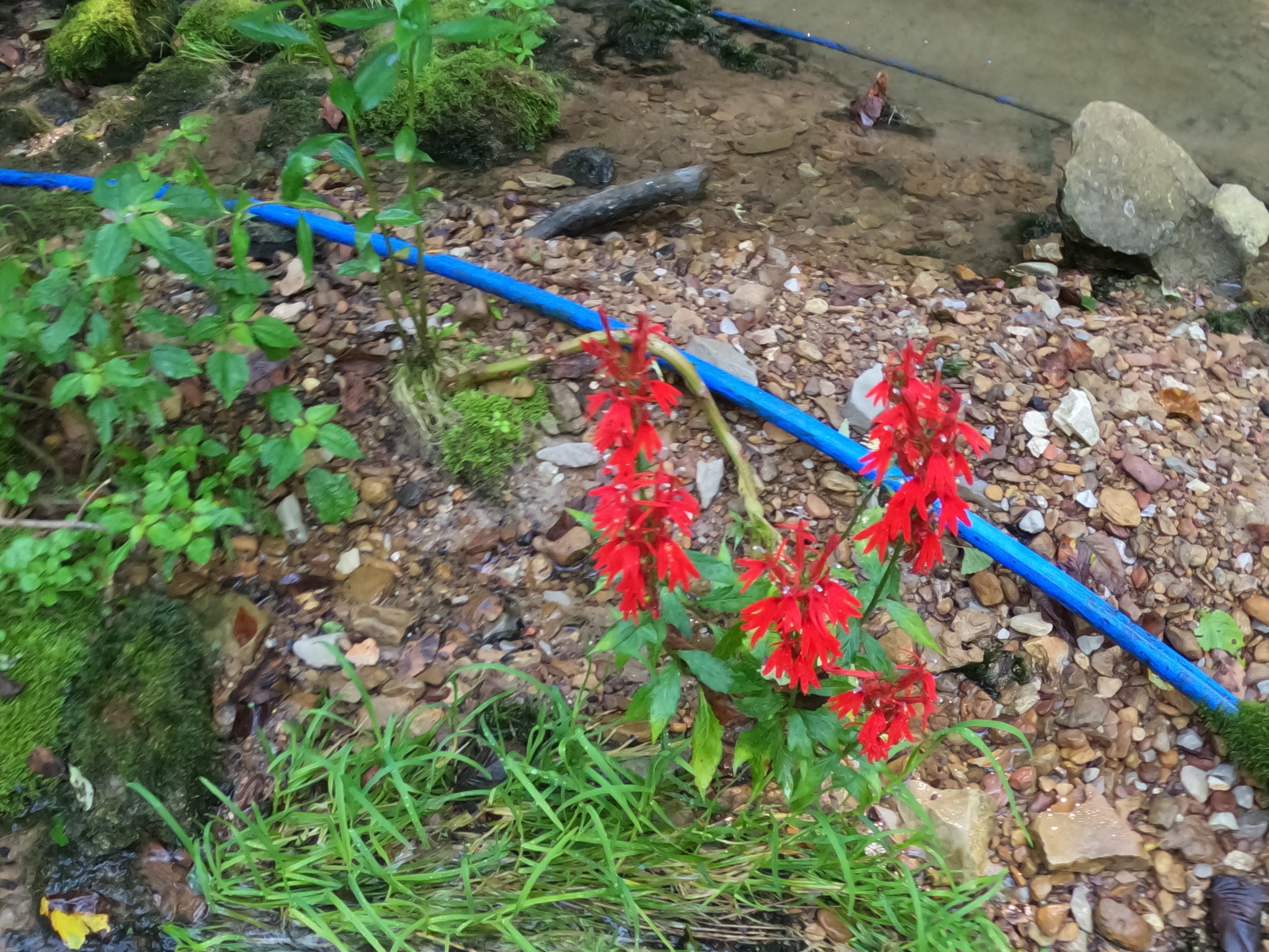
We went up the road toward the start of the River Trail. We got to swift ford and crossed. The water levels this weekend were low to normal. The river looked beautiful. Bright red cardinal flowers , purple phlox and pale purple asters grew on the banks.


Below: bold red cardinal flowers

 Above: East Fork River flowing north below the ford


Below: tall purple phlox


Above: The rim of the swimming hole at the ford where the water begins to rush forward. Standing here right a this moment I began to awaken to something in me that had gone dormant.


Above: The rim of the swimming hole at the ford where the water begins to rush forward. Standing here right a this moment I began to awaken to something in me that had gone dormant.
We puttered around the swimming hole and tried to decide what came next? Otey the dog was along and being such a good boy. I was concerned if he was comfortable? Did he need to go back to the house? Did we need to get him his dog bed? Sharon reassured me he was fine. He had a pillow and was okay. (The Kooglers are tryin' to kill me!) Kenny made our minds up for us as to what was next. He often wants me to call the shots on where we go, but today it was all up to him. I wanted ALL of it! I was indecisive. He took us upstream along the trail. We forded again. Evidence of flooding was all around us. The East Fork Obey River is not to be trifled with. It is a powerful river and at flood stage it does not play nice.

Above and below: Looking upstream at the next ford at all the uprooted trees and logs and debris.

Below: Looking downstream at this ford it is clear of logs since they mostly got hung above this spot. See the green water over in the distance? Over there is where more water joins the river from underground.

We headed further up river and I have to say the flooding has done nothing to make it easier to follow. It is a confusing mess that changes all the time. We made it up to one stretch where the river is a pretty blue. It is just before the blue hole. The trail has had a rut across it from the start, but it has grown worse each year from run off. It is soon going to be impassable without some work. We need to take a day and come over and try to place some logs across it before it is completely shot. The embankment here is such and the gully .. the terrain will make it damn near impossible to fix or re-route. Poor Danny Smith passed away since we were there last. The fellow who owns the access to the Bills Creek end of River Trail could easily decide to stop allowing folks to use it. I would not be surprised, but I hope that doesn't happen.
We went on up to the Blue Hole. It was full of water and looking awesome!  Above: Beginnings of the Blue Hole. Just before it.


Above: River Trail pretty clear in this spot.

Above: Otey, Sharon & Kenny ahead of me.

Above: The prettiest vista of the day. That aquamarine color is the color of the Cumberland Plateau to me.
Below is a highlight reel of the ride today on the River Trail from start to finish.
We motored on upstream from the blue hole. Kenny had thought he'd go up to Wilder and around. I really did not want to go that way. It was one thing that just did not appeal to me today for whatever reason. He said we'd compromise. We got to the mouth of Big Piney Creek which at this level is a dry wash. In order for there to be water flowing out of Big Piney and merging with the Obey it needs to be flooding. We turned and headed up hill on a side path that would bring us out in the Wilder Subdivision. It had been a very long time since we went through there. It began to look familiar and then I remembered where we were. We rounded a bend and sure enough there it was! The Octagon House! It is an abandoned eight sided house sitting out in the forest. It belonged to some neighbors of Sharon's at one time. I think they have sold it if memory serves. A shed was behind it and a grill sat next to a tree. I had been here before, but had not noticed those features in the past. I love finding the weird stuff.

Above: The octagon house. The front door faces the opposite side. We did NOT go in.
More houses have been built in the Wilder Subdivision once we got up there. We stopped by a nice overlook to take in the view. It was a nice clear day. We could see the various overlooks even over to Hoodtown.  Above: Dramatic, interesting rock outcrop at the overlook

Below: Sharon at the overlook

 Above: View from the overlook


I got to see and enjoy loads of late Summer wildflowers on this ride. Deep purple New York Ironweed with yellow swallowtail butterflies was abundant. Spotted jewelweed in lemony yellow and deep orange. Black eyed susies, tall joe pye weed in pastel pink waved in the breeze like tall pink fans. Clusters of sunflowers and golden wing-stem were all around.

Below: swallowtail butterfly on New York Ironweed

 Above: Black eyed susans


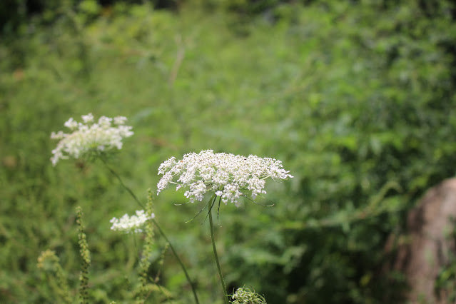
Below: Queen Anne's Lace

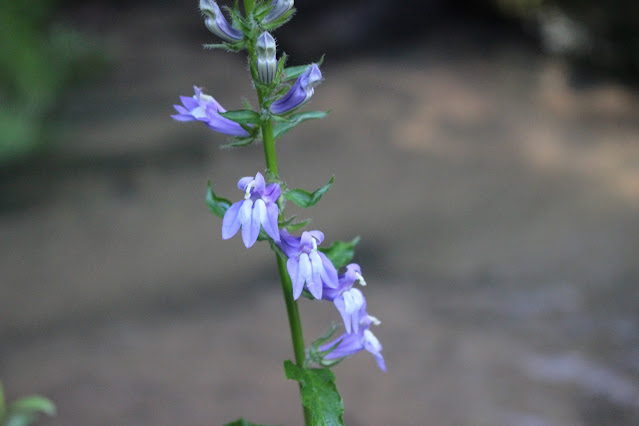
Below: Downy lobelia was seen in many spots on the trails and roadsides.


Below: Pale Joe Pye Weed starting down into Big Piney

 Above: This neat stone house is built partially below ground. This is protection against tornadoes and thermal protection against temperature changes like extreme heat or cold. Makes it easier to heat and cool your house! You see a fair amount of this out in this area.
 Above and below: One of my favorite old houses is still standing. I thought by now it would either be demolished or have fallen in.


We got round to Manson Road where we began to see the old house, the underground house, and spots where lots of junk cars are parked by the roadside. Many ponds and pretty fields of wildflowers.
We turned into the upper end of Big Piney. We were pleased to find the gate still open and the trail clear. It is always pretty down in there and cooler. Today the stream had very little water in it, but what is there was flowing and was extremely clear. By the time we got to the last ford the stream was gone underground.
 Above and below: views of Big Piney Creek at its upper end where the water still flowed. Otey got him a drink here.


We paused for a lunch break and a leg stretch at the first ford in the shade. Nothing blooming down here this time of year. Not much at all of any note. We did not see a single snake all weekend!
Big Piney wasn't as pretty or interesting as usual so we did not tarry, but headed onward. We felt the temperature rise as we climbed out of the gorge. Back up on plateau level we were out on Manson Road again. We discussed options for our ride from here. We opted for the shorter one toward the closest way to close the loop of our ride. We ended up going toward and past Bills Creek and round to Manson Road and turned up the trail along the base of Skinner Mountain. We crossed the top of the mountain and came down to Boatland Road again. There were some places along the ride where a bit of Fall color crept into the tree leaves, but up on top the trees were still quite green. The only thing we found of any note was some chanterelle mushrooms for Sharon to harvest.
The road down Skinner Mountain is not any worse, but it is certainly no better. It is deeply rutted out.
We didn't make it down the road to the bottom without Kenny splattering us with stinky black mud!
Once back a the house we changed clothes and cleaned up a bit. I had a cup of coffee to pep me up.
We took a brief rest and headed to the beach to swim. The river looked so cool and green. The beach was shady with the golden glow of evening starting. The sunbeams danced off the water onto the bluffs above. You can see it on the video of the river. I played with the Go Pro taking underwater photos and video. It is getting easier to learn to use. I enjoyed it. I put all the camera gear up since I just wanted to swim and float. We spent a couple hours in the water cooling off. Kenny napped in a beach chair. Otey played and swam.. It was marvelous. The water was initialy cold, but once I got in I was fine. It felt great.
We saw great numbers of wild ducks flying over today. We also saw a great blue heron. We saw three hawks as well.
Below is a series of photos taken in and under the water of the Obey River.


Swimming in this aquamarine liquid is marvelous. The only thing we talked about doing this weekend that we did not get to do was go tubing, but there is still some Summer left. Who knows?!


Below is a video I made of Woo Hoo Beach. It is very mellow and captures the mood well.

Above: the living room in Sharon's cabin. It is beautiful. I am proud of my friend for making her dream come true.
We were all worn out by the time dinner rolled around. We just had warm ups from the previous night and a good, fresh salad. I sat down with the Big South Fork guidebooks and map and did some brain storming on places we might go hiking the next day. It occurred to me how many times Kenny has said we should go back to Twin Arches. I also thought of how many times Sharon has encouraged me to hike to Charit Creek Lodge. I looked at the map and compared the waypoints on the database to some other features in the vicinity. We all agreed we'd hike to both Twin Arches, Charit Creek and then depending on how we felt we'd possibly hike to Buffalo Arch and some other nearby features.
We slept well knowing we had a game plan for the next day. Something to look forward to.
Day 2 Big South Fork Hiking
We got up and got going at a decent time on Sunday morning. We headed to Big South Fork to hike Twin Arches and Charit Creek. It is not a real long hike. We were a little surprised to find the parking lot very full today, but it was a holiday weekend. Even with lots of folks hiking it was not terribly crowded. Just enough people to make it pleasant. The people we met were very friendly and fun to visit with along the way. We had some laughs with a couple of lady hikers, another pair of young Asian ladies, and a family group. Plenty of other dogs on this hike, and Otey is the BEST hiking dog with the nicest manners. It was sweet to see how many of the dogs wanted to play and visit.
We hiked to the arches clockwise as suggested by Sharon. The first time we hiked it counter clockwise. That takes you across the top of the North arch first. We quickly covered the first part of the trail arriving at the steep stair cases down. They aren't bad, but they'll get your attention.
Below is a snapshot of the look down the first flight of stairs. I've been having trouble with my left knee so was extra careful. Going down is a lot tougher for me than coming back up. Otey shepherded us along the way today. He hiked the trip twice over running ahead and coming back to check on us. He hung in there with me as my sweep. Sharon asked me if he'd put his nose on the back of my leg yet or my ankles? I was pleased to be able to say no. It never got to the point of him having to urge me along.

The trail is shady, cool, through some pretty forest with big trees and impressive bluffs. It seemed like no time until we arrived at the North arch. Lots of other hikers here. It was an awesome sight! They are huge and beautiful. We spent a little time resting and enjoying the scenery before pressing onward to the next part. We went to the south arch and the fat mans squeeze tunnel through it! Sharon knew of it, or we'd never have experienced it. It was fun. It is a little tricky and you'd be best off going through it the opposite way of what we did. Once again... easier going up than coming down for me. My left knee is a bit unstable. We had some good laughs here with the other lady hikers we kept running into. They were fun. Very jovial.
Below is my first good look at the north arch in years! It was over a decade since we hiked to this.


Below is my favorite photo of the North Arch. 
We made our way around to the South arch very quickly. More hikers here, but not as many.
I encountered Henry here. A very cute little boy with his family. He wanted to pet Otey so much. Otey was a rescue dog. Someone in the past mistreated him. He has a nervous disposition around children.
I explained, but Otey warmed up to him and accepted some love and pets from Henry. He was real tickled. He said "I love the doggie!". I asked to take his picture and he and his parents consented. I told him to look for his photo on Cumberland Gal. I kept his photo us as front page cover for a week.


Below is a video of our visit to Twin Arches including the squeeze.
Once we had visited both arches we hiked onward toward new territory for me and Kenny. Charit Creek Lodge. The hike there was easy. It was all level or downhill. It was all shady and that helped a bunch. Today we had remembered to spray ourselves down prior to hiking with plenty of DEET containing Deep Woods Off! bug repellant spray. Big South Fork is the only place I've ever hiked where we got deer ticks. I did not want Lyme disease or to spend hours with a magnifying glass and tweezers checking one other for ticks! Those little buggers are like a speck of pepper!
We did not get a single tick today nor a mosquito bite. Sometimes we get things right.
The scenery on the way to Charit Creek Lodge was pretty, deep green forest. More rock forms. Lots of big trees. Sharon found and foraged an entire walmart bag full of oyster mushrooms and one lobster mushroom. They were growing by the trail. It was quite something to see. She took a class and has done some self education on wild edibles. I am impressed!
Charit Creek came into view and with it we heard the sounds of machinery. A generator of some type was running. The creek was pretty. It had plenty of water, but it was not a good place to swim. Too shallow. We popped round the bend and could see the lodge and all the neatly manicured grounds.

Below: Charit Creek lodge and grounds


Above: barn a Charit Creek
Below: Fire pit and chairs for lounging

We sat on the porch a the lodge and cooled off. Kenny bought us cold drinks and salty snacks. We opted to eat lunch once back at the truck after our hike. We visited with a few other guest and hikers. We strolled the grounds. It was really nice. I am glad to be able to say I have now been to see it.
It is a pretty place and very quiet. The grounds have some pretty Summer wildflowers.
The only interesting flower I saw on the trailside today was one lonely cranefly orchid.
Below is a picture of it. It was kinda droopy.

Once we had cooled off a bit and had a good drink including Otey the dog having a drink... we began our hike back. It was harder on the return hike in that it was uphill and it was hot and humid. Down in the gorge we got only a breeze now and then. Thankfully it was all shady though still. I hiked ahead of Kenny and Sharon since my knee was doing better on the hike back out. It hurt less. It was more stable. I just kept going while Sharon and Kenny stopped for her to pick mushrooms. I used the time to motivate forward. We caught up to one another at the North Arch. We originally thought we'd hike the steps back up and out across the top. We were so hot and tired we decided against it. The trails are equal distance at 0.7 miles to the parking lot, but the one over the top of the arches is in the hot sun.
We got back to the stairs at last and I noticed how they looked higher coming out than they had going in. It was my fatigue making it appear so. Once we got up there the terrain was a little more forgiving. One more gradual uphill push and the terrain flattened out like a fritter and we arrived at the parking area. There are restrooms there, but I had lost so much salt and fluids perspiring that I didn't even need a bathroom break. I wasn't drinking enough. I was so hot I never was able to eat lunch.
I did not eat anything for quite awhile, but drank water and gatorade. I finally ate some salty crackers to put back the electrolytes and give me some energy.
Below is a video of the highlights of Charit Creek lodge
We were all tired and hot. Kenny predicted correctly that the time would be late getting back to the truck. It was 4:30 p.m. We were not up for more hiking, but we had a couple stops to make at attractions that were roadside. We headed up into Kentucky to visit Hollow Rock and Fiddlers Rock with Sharon.
Hollow Rock and Fiddler's Rock
The drive up into Kentucky was short, but it felt good to be in the air conditioning and have wheels transporting us for a little bit. I had reviewed Hollow Rock briefly and knew the main turns, but in my mind it was along the main road. We were to be reminded this was not the case.
The drive out Parkers Mountain Road is a pretty one. There are several nice overlooks with great views on either side on the way. We stopped at each one. I am posting a photo of my favorite one.
It was such a bluebird clear day for being outdoors.

Above: Beautiful view to the south off Parkers Mountain Road in Kentucky.
Below is a brief video of this stop to take in the view.
We were too tired to hike to Buffalo Arch this evening. We passed the trailhead for that on our way. Here are directions on how to hike it from the north and south ends.
Buffalo Arch Hike Directions
The road was dusty, but the views spectacular. The roadsides were dotted with deep purple New York Ironweed each one with yellow butterflies flitting. Deep, red orange spotted jewelweed was by the roadside. Tall pink fronds of Joe Pye weed waved in the breeze. Lots of yellow sunflowers of different sorts bloomed. We went ever onward and had difficulty locating both Fiddlers Rock and then Hollow Rock. We got to the turn for Bell Farm Road and knew we'd missed both. We turned around and started back looking diligently for them. We passed a side road and thankfully Kenny remembered something about it. He said he thought this was it. We turned aside to check and he soon remarked "This is looking right to me. This is familiar". Sure enough this single track road was our spot to find Hollow Rock. It is a low, wide arch that has been heavily vandalized by graffiti and fires and partying. We were thrilled to find it once more.
We pulled over best we could hoping no one else came along needing to pass. This road sees little traffic so we needn't have worried.
Hollow Rock is visible from the road quite easily. In Winter on our first visit we could see it from the lower road, and found our way to it by exploring. Today in Summer it was not visible thanks to all the green leaves. The arch and the terrain are soft sandstone so the path coming down to the road is very soft and sandy. It spills out into the road making it hard to get turned around. Between that and the narrow space it wasn't an easy task when we went to leave.
We walked the short distance up to the arch to check it out. It is impressive, but messed with.
We found some kind of metal rod sticking up out of the soil. It looks like a survey marker of some type. It had writing on it, but it was impossible for me to make it out.
Below is a photo of Hollow Rock from the road Above: another view of the arch with graffiti.
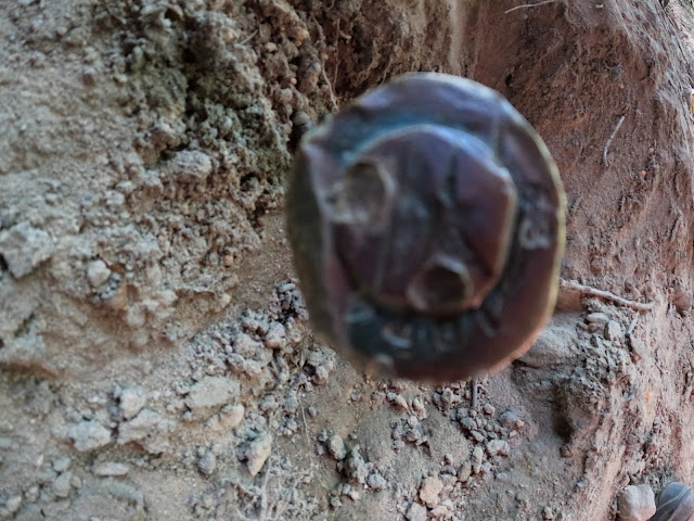 Above: metal object like a rod with a cap embedded in the ground under the arch


We enjoyed strolling round looking at the arch. We were happy to have been able to locate it again. I have posted a video below that shows it better than any picture. We got tickled at the foolish stuff the graffiti taggers thought was a good idea to write. Brain donors the lot of them.
We got done visiting the Hollow Rock and headed back to the truck. We continued onward to try to relocate Fiddler's Rock. I am not including directions to this because of the reason above. Hollow Rock is a prime example of what ignorant, destructive humans will do to something special if given the chance. Not all are like that, but I was entrusted with the location by another and I trust Sharon to be a good steward of the information. She is my best buddy and I know her character.
We finally managed to find Fiddlers Rock once more and stopped to check it out. It was like Hollow Rock in that the full leaf out of Summer made it harder to find. It is a flat rock in the ground that acted as a sort of stage beside an old road. It was where the fiddler stood to play music for dancing. All sort of carvings are in the stone. A fiddle and bow, a rifle, a cowboy, and the date 1894. The rock is still in good shape having been unmolested, but the lichens and moss are gradually covering it up making it harder to see the engravings. Sharon enjoyed seeing it and we did too. I knew she liked this sort of historic thing.
Below is a photo of the fiddle with the bow beside it. Seeing this and being in Kentucky made me think of one of my favorite songs. My father in law was of French Canadian./Native American descent a Metis and Le Reel du Pendu (Hangman's Reel) and Devil's Dream fiddle tunes were ones he liked and listened to as a border jumper. How I miss him and his Cadian music.
Frail my heart apart and play me a little shady groveRing the Bells of Rhymney til they ring inside my head foreverBounce the bow and rock the gallows for the Hangman's ReelAnd Wake the Devil from his dream"--Anna & Kate McGarrigle "Going Back to Harlan" made famous by Emmy Lou Harris

Above: fiddle and bow carving
Below Rifle carving and the feet and boots of the cowboy.

I did not get any good images of the cowboy this trip, but below is a video that illustrates what this spot is really like. It shows it all better.
We were growing very tired and still had to drive home. We wrapped up our adventure for the day having fit a lot into it. We got back to the cabin and put things away and cleaned up. We were all so tired. Sharon got to work cleaning and preparing the mushrooms she found. I tasted my first cooked shitake mushroom and they truly are delicious. I ate some raw years ago and got dog mud sick. I did not know that almost all mushrooms need to be cooked before eating them.
We had a delicious dinner of spaghetti and Italian sausage and garlic bread. We briefly discussed plans for the next day. The only thing I wanted to do for sure was check out a nearby natural spring Sharon had told me about. I had driven past it too many times to remember always admiring it, but never exploring it. It is an an awkward area with lots of fencing and a steep bank. We were going to try crawling through the culvert beneath the road to visit it.
Despite being tired we still sat up and giggled and visited. Kenny told me on the drive home how much he enjoyed himself. He said one of the things that blessed him was to hear me and Sharon gabbing and laughing. We have such a good time together. She is a love.
Finally we turned in to get some sleep for the next day's adventures.
Day Three--Glenobey Spring
We had a simple breakfast the next morning so we could get going. Just coffee and a pastry.
Kenny and I had to head home this evening, but we were going to fit in some fun before that.
We took the Polaris rzr and headed round to where the spring is located. Glenobey Road is partially closed in the middle because of a landslide. Thankfully it did not prevent us from reaching our destination. There is a large spring of water emerging from the ground here. There is also a creek bed that is dry much of the year. It is a fun place to rock hound! I found some good stuff today. Chalcedony (Cal-SEDny), Flint, a couple fossils of ancient marine life, fossilized coral, and the glass liner to a zinc jar lid!
The spring was beautiful and the hollow it sits in a verdant green. It was cool down here, but you could feel temperature variations. Puffs of warm air then cool air. Like the earth itself was breathing. Upon seeing the culvert the stream flows through it looked very small, dark and spooky. We weren't too sure about crawling in there. I was the first to work up the nerve to go over and at least look into the mouth of the culvert. I was filming with the Go Pro. I left my camera and backpack sitting in the dry creek bed. The next thing I knew I was in the culvert going to the other side! It wasn't scary and there were no spiders or snakes in it. I could see there were logs blocking part of the far end, but I'd figure that out once over there.
Below: Beautiful spring of water by the road. That culvert looks small and dark!

Below is one of my favorite views of the cave and spring once I got across


Below: Great Blue Lobelia blooms on the sides of the spring.
Below: Here is a spring box or what's left of one. Covered in moss.

Below: Here is a spring box or what's left of one. Covered in moss.

Below: my best fossil find today. A shell of some type


Below is a view of the cave/rock house with cardinal flowers.

We investigated the source of the water. Part of it flowed directly out of the ground to the far left side of the spring. It wasn't enough water to account for that volume though. We checked out the cave entrance and there is where most of the water comes from. You can hear it roaring in there and see the movement of the water. The entrance is small and I am not sure if it is possible to climb in there to get a better look. There is a thick shelf above the entrance. It doesn't keep going. You can't climb up there and then climb down through any larger entrance.
I made a two part video of the spring exploration that shows all this really well. You can get more out of it by hearing it and looking all around 3-D.
Below: Glenobey Spring exploration part 1
And below here is Part 2 of the exploration
I could feel the healing and nourishing taking place as I explored. Soaking up all this beauty for my eyes. The fresh air. The feel of the cool water on my skin. The textures of the rocks. The sounds of the water bubbling and the birds singing. It was like I have been on a starvation diet and did not realize what I was doing to myself. The fellowship of my husband and my best friend really were just the best. I am blessed to call Sharon a friend and need to maintain that friendship better. Friends make life better with their love and company.
Dangerous Swimming Hole
I could have spent all day exploring that spring, but there was more in the area we wanted to check out. Finally I tore myself away and we got in the SXS and started toward the river on a trail Kenny found. It used to be possible to go into the field and find a place to ford the river and come out down here. Now that land has been sold by Butch Campbell to another. The river trail no longer makes the connection Glenobey Rd. We didn't go far at all until we arrived at a beautiful swimming hole in the river. A rope swing was on the opposite bank.
It was hot enough I looked at Sharon and asked "Do you want to get in?" I was seriously considering it. She was not tempted at all and told me why. She said "I'm a little afraid of it. Ed told me that this is a dangerous place to swim. It is deep and there is a current." Apparently two of Ed Choate's relatives tried to swim across the river here and drowned in the attempt. It is wider and deeper than most places on the East Fork. It also sits right in a bend of the river.
While it is a beautiful spot it isn't to be trusted. Ed was a free spirit, but not a complete fool.
Sharon loves this river and if she won't get in that spot I'm not about to.

Above is the beautiful spot with the high bluffs and deep water in the river bend.
We saw lots of fish guts and stuff at the water's edge where someone cleaned fish.
It looks like they caught a bunch of Buffalo fish. One of them was thrown back.
Below is a video of this dangerous, but beautiful water hole.
Below is another view upstream. The tree across the river is the one with the rope tied to it.

Below: Right here at this pretty green spot was another spring trickling steadily out of the bank and flowing into the river. Despite not swimming here, there was still plenty to explore and it is a nice spot.

Below is a video of this bubbly spring
A
Above: The stream that flowed from the large spring we'd just come from flowed all the way down and joins the East Fork here at this pretty hole of water. I am standing in the stream looking up it.


Above: I waded the creek enjoying the cool, clear water. I followed a little leaf floating downstream like a tiny boat.
We finally decided to mosey onward having seen all of the springs we cared to check out. I noticed a field with lots of colorful wildflowers on the way. Kenny pulled over to let me see and photograph them. It was a simple farm field laden with purple and gold. Butterflies of yellow, black and orange flitted from blossom to blossom. Bees buzzed round. The cicadas hummed.
Frogs hopped in the mud holes as I walked by. It was a hot, sunny, beautiful place with a sweet scent of hay and flowers. I also saw passion flower and their fruits "may pops".


Below: unripe fruits of passion flower.. May pops!

Below: close up of New York Ironweed

Below: golden wingstem up close view


Above: butterfly on ironweed
Below: humble yet beautiful Goldenrod

We headed back the way we had come until we reached the dry creek bed. Kenny said he wanted to ride up it a ways and show us how it looked. We stopped to take a photo of the bridge over the dry stream.
Below is a photo of the bridge. It looks odd over that dry creek bed.

The stream bed was an interesting place. It was flat with only a tiny bit of water now and then. Evidence of massive flooding could be seen along the way in the form of large trees downed and debris mats caught in snarls. Riding along we saw a cave on the right and one on the left! Someone set up a camp with chairs on one side. We also saw a crazy sight. Some sort of large well box with a blue hose running from it and a spigot on the end! I got out to photograph it. I turned it on and it dripped a little water. I'd say it didn't have enough pressure to allow for much flow.

Below: I have turned on the tap to see what would come out?! A little water.

 Above: flat creek bad looks like an old road. It had numerous side paths taking off. We explored a few of them. It needs further investigation.


Below is a cave entrance we saw.

We were growing hungry and the day was getting late. We decided we'd best head back.
On the way Sharon saw some of her other friends so we stopped briefly for her to greet them.
This was the same group of friends who originally came up with the idea to walk under the culvert to the spring, but we beat them to it! ha!
We made it back to the cabin and had a quick lunch of the sandwiches we packed the previous day.
We gathered up our belongings and packed up to head home. We said our goodbyes and I hugged Sharon and promised I'd not let it be so long between visits again. I will keep my word. It harms me when I neglect my own relationships and spirit. The visit this weekend reordered my priorities and got them right again. I decided to shelve the concerns about finishing lists and return to who and what and where makes me happiest. My friend Sharon. The beautiful Cumberland Plateau we love to explore.
I set about looking for a get away place there in earnest. Just having returned to my true self was a refreshing feeling. I found what I had lost. I am learning to be me again after a period of caring for others. It is time to take better care of me and my life.
The only thing I wanted to do this weekend that I did not do was to visit Cumberland Mountain General store. It is temporarily closed. They are transitioning to a new owner. Highway 127 expansion is underway. The road widening should not ruin their business or force the closure, but it is a nuisance right now. It is on the opposite side of the store, but won't destroy it. At least I hope not.
I will hope to get to visit there again.
On getting home we had a visit from daughter Crystal and son in law Adam and our two oldest grandkids Michael and Tessa. We had the entire family there. Adam got the position of Chief at the airbase! We celebrated that and it was Tessa's official tenth birthday so it was good to spend a little time with her. We already had a family celebration a few weeks back, but today was the day she actually arrived 10 years earlier! We are proud of her and all our grandchildren.
I am already looking forward to the next adventure.
No comments:
Post a Comment
Thanks for reading and commenting. I enjoy hearing from those who read & make use of my blog. I have made some wonderful friendships through emails from readers. I respond to all comments and emails. I appreciate folks reaching out to let me know when my blog entries are not functioning correctly or if the situation somewhere has changed. Many Blessings to you!
Dana 🐝